Please login to see price!.
Subscribe to be notified if similar examples become available.
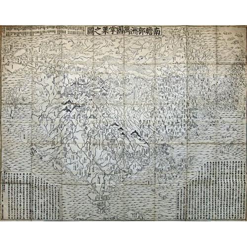
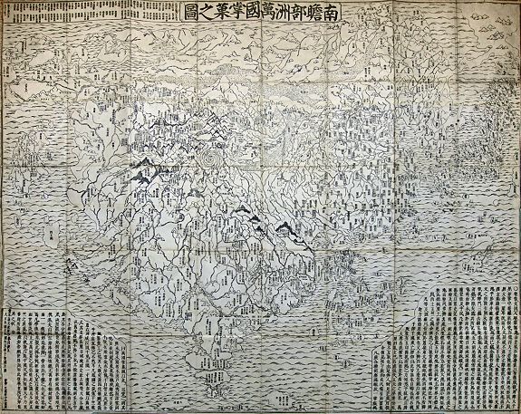
Nansenbushu Bankoku Shoka No Zu [Outline Map of All Countries of the Universe] |
||||||||||||||||||||
|
||||||||||||||||||||
|
|
||||||||||||||||||||
|
Selling price: $...
Please login to see price! Sold in 2014 Missed this item! Be the first to get notified about our newly added listings. Add your name to our mailing list. Feel free to contact us if you have a question about this item. |
Virtual Collection - Save and collect this or any of your favorite items in one place.
If you want to save the items permanently, please sign in or create account first. |
|||||||||||||||||||
Description
This map issued by Bundaiken Uhei is a great example for Japanese world maps representing Buddhist cosmology with real world cartography. It is the earliest one and - therefore - the prototype for Buddhist world maps.
The map centred on 'Jambu-Dvipa', the mythological heart of Buddhist cosmography where Buddha was born in Northern India with the sacred lake of Anavatapta, and the four sacred rivers Ganges, Oxus, Indus, and Tarim flowing from it, the map extending from Ceylon to Siberia, and from Japan to the British Isles 'Country of the Western Woman', with Europe as a group of islands, Africa figured as a small island, and a land bridge connecting China with an unnamed continent to the East [?America], numerous place names, texts placed at lower left and right corners including a list of Sutras and Chinese histories, title in a banner at upper margin.
At the time being, Japan maintained an isolationist policy which began in 1603 with the Edo period under the military ruler Tokugawa Ieyasu, and lasting for nearly 270 years. Although knowing the world map by Matteo Ricci, published in Peking in 1602, Japanese maps mainly showed a purely Sino-centric view - or with acknowledgement of Buddhist traditional teaching - the Buddhist habitable world with an identifiable Indian sub-continent.
The map was drawn by the scholar-priest Zuda Rokashi (1654-1728), or Hotan his religious name, is the founder of Kegonji Temple in Kyoto, and illustrates the fusion of existing Buddhist and poorly known European cartography.
The language is Chinese, except for a few Japanese characters on the illustrations of European countries.
South of Jambu-Dvipa, India is recognizable for in its peninsular form. Japan itself appears as a series of islands in the upper right and, like India, is one of the few recognizable elements - at least from a cartographic perspective. China and Korea appear to the west of Japan and are vaguely identifiable geographically, which itself represents a significant advancement over the Gotenjikuzu map. Southeast Asia also makes one of its first appearances in a Japanese Buddhist map as an island cluster to the east of India.
Europe, which had no place at all in earlier Buddhist world maps, making this one of the first Japanese maps to depict Europe, is shown at upper left as a group of islands, which can be identified from Iceland to England, Scandinavia, Poland, Hungary and Turkey, but deliberately deleting the Iberian Peninsula. Umukari [Hungary], Oranda, Baratan, Komo [Holland or “the country of the red hair”], Arubaniya [Albania?], Itarya [Italy], Suransa [France] and Inkeresu [England] are all named. Africa appears as a small island in the western sea identified as the “Land of Western Women.”
On the lower right South America is featured as an island south of Japan with a small peninsula as part of Central America, carrying among just a few place-names including four Chinese characters whose phonetical Japanese reading is “A-ME-RI-KA”. North of Japan, a land bridge joins Asia with an unnamed landmass, presumably North America. Africa is not shown at all. On the other hand, this map is much more than a world map and the main concept by the author was to celebrate a historically very important event. The map echoes the pilgrimage route of the famous Chinese Buddhist priest Hsuan-Tsang (or Xuan Zhuang, Genjo in Japanese; 602-664 A.D.), who travelled to India to visit sacred places of Buddhism and also to collect holy sanskrit writings.
On the other hand, this map is much more than a world map and the main concept by the author was to celebrate a historically very important event. The map echoes the pilgrimage route of the famous Chinese Buddhist priest Hsuan-Tsang (or Xuan Zhuang, Genjo in Japanese, 602-664 A.D.), who travelled to India to visit sacred places of Buddhism and also to collect holy sanskrit writings. So the largest part of the map is depicted to "Jambu-Dvipa" with the sacred Lake of Anavatapta (Lake Manasarovar in the Himalayas) at center, from which the 4 rivers Ganges, Oxus, Indus and Tarim are flowing. This all was based on the Japanese version of Hsuan-Tsang's Chinese narrative, the Si-yu-ki, printed as late as 1653. Here numerous details are given, including the interesting feature of the so-called "iron-gate", shown as a strongly over-sized square, and the path taken by the monk whilst crossing the forbidden mountain systems after leaving Samarkand.
Also, at the upper left corner 102 references from Buddhist holy writings and Chinese annals are mentioned to increase the credibility of the map.
The first Buddhist world map printed in Japan and the prototype for all subsequent Buddhist world maps printed in Japan until the late nineteenth century. The author, Hotan (1654-1728), was a scholar-priest and founder of the Kegonji Temple in Kyoto. The earliest known example in Japan is the Gotenjiku Zu (Map of the Five Indies) by the priest Jukai dating from 1364 and now preserved in Horyuji Temple in Nara. However Hotan’s map was revolutionary in being the first printed Oriental map to introduce detailed Western cartographic information into this traditional Buddhist cosmological view and to attempt to merge the two together into a comprehensible form. Europe is depicted as a series of islands in the upper left of the image whilst South America is likewise another island in the lower right of the image. Africa is omitted completely. China and Japan are clearly defined in the upper right of the map. The popularity of the map is evidenced by the fact that although the map is dated 1710, it was reissued unchanged in numerous editions through to about 1815 and spawned innumerable copies and derivatives over the next 150 years. a rare and important cartographic work.
The map is based on the pilgrimage route of the famous Chinese priest Hsuang-Tsang (602-604) who traveled to India in the 7th century to collect holy Sanskrit writings. The first printed Japanese version of the Chinese narrative of the Si-yu-ki was issued in 1653, and was a major incentive for the publication of this map, which was used for Buddhist propaganda and education. The earlier ones were published by bookseller Bundaiken Uhei(fl. 1680-1720) and later was succeeded by Chobei Nagata of Kyoto. Bundaiken Uhei’s mark and name appear in the lower left quadrant. In most examples coloration varies.
Nowadays map of this kinds become rarer and rarer especially in good condition and strong image even in Japan.
Reference: K.Yamashita, Japanese Maps of the Edo Period, pp.32-33 ill. - Nanba, Old Maps in Japan ill. 8. - K.Unno, Cartography in Japan, 1994, page. 346-477 and illustration 11.59. - Cortazzi, Isle of Gold page 38 and col.ill. 48. - Beans Coll. 1
The map centred on 'Jambu-Dvipa', the mythological heart of Buddhist cosmography where Buddha was born in Northern India with the sacred lake of Anavatapta, and the four sacred rivers Ganges, Oxus, Indus, and Tarim flowing from it, the map extending from Ceylon to Siberia, and from Japan to the British Isles 'Country of the Western Woman', with Europe as a group of islands, Africa figured as a small island, and a land bridge connecting China with an unnamed continent to the East [?America], numerous place names, texts placed at lower left and right corners including a list of Sutras and Chinese histories, title in a banner at upper margin.
At the time being, Japan maintained an isolationist policy which began in 1603 with the Edo period under the military ruler Tokugawa Ieyasu, and lasting for nearly 270 years. Although knowing the world map by Matteo Ricci, published in Peking in 1602, Japanese maps mainly showed a purely Sino-centric view - or with acknowledgement of Buddhist traditional teaching - the Buddhist habitable world with an identifiable Indian sub-continent.
The map was drawn by the scholar-priest Zuda Rokashi (1654-1728), or Hotan his religious name, is the founder of Kegonji Temple in Kyoto, and illustrates the fusion of existing Buddhist and poorly known European cartography.
The language is Chinese, except for a few Japanese characters on the illustrations of European countries.
South of Jambu-Dvipa, India is recognizable for in its peninsular form. Japan itself appears as a series of islands in the upper right and, like India, is one of the few recognizable elements - at least from a cartographic perspective. China and Korea appear to the west of Japan and are vaguely identifiable geographically, which itself represents a significant advancement over the Gotenjikuzu map. Southeast Asia also makes one of its first appearances in a Japanese Buddhist map as an island cluster to the east of India. Europe, which had no place at all in earlier Buddhist world maps, making this one of the first Japanese maps to depict Europe, is shown at upper left as a group of islands, which can be identified from Iceland to England, Scandinavia, Poland, Hungary and Turkey, but deliberately deleting the Iberian Peninsula. Umukari [Hungary], Oranda, Baratan, Komo [Holland or “the country of the red hair”], Arubaniya [Albania?], Itarya [Italy], Suransa [France] and Inkeresu [England] are all named. Africa appears as a small island in the western sea identified as the “Land of Western Women.”
On the lower right South America is featured as an island south of Japan with a small peninsula as part of Central America, carrying among just a few place-names including four Chinese characters whose phonetical Japanese reading is “A-ME-RI-KA”. North of Japan, a land bridge joins Asia with an unnamed landmass, presumably North America. Africa is not shown at all. On the other hand, this map is much more than a world map and the main concept by the author was to celebrate a historically very important event. The map echoes the pilgrimage route of the famous Chinese Buddhist priest Hsuan-Tsang (or Xuan Zhuang, Genjo in Japanese; 602-664 A.D.), who travelled to India to visit sacred places of Buddhism and also to collect holy sanskrit writings.
On the other hand, this map is much more than a world map and the main concept by the author was to celebrate a historically very important event. The map echoes the pilgrimage route of the famous Chinese Buddhist priest Hsuan-Tsang (or Xuan Zhuang, Genjo in Japanese, 602-664 A.D.), who travelled to India to visit sacred places of Buddhism and also to collect holy sanskrit writings. So the largest part of the map is depicted to "Jambu-Dvipa" with the sacred Lake of Anavatapta (Lake Manasarovar in the Himalayas) at center, from which the 4 rivers Ganges, Oxus, Indus and Tarim are flowing. This all was based on the Japanese version of Hsuan-Tsang's Chinese narrative, the Si-yu-ki, printed as late as 1653. Here numerous details are given, including the interesting feature of the so-called "iron-gate", shown as a strongly over-sized square, and the path taken by the monk whilst crossing the forbidden mountain systems after leaving Samarkand.
Also, at the upper left corner 102 references from Buddhist holy writings and Chinese annals are mentioned to increase the credibility of the map.
The first Buddhist world map printed in Japan and the prototype for all subsequent Buddhist world maps printed in Japan until the late nineteenth century. The author, Hotan (1654-1728), was a scholar-priest and founder of the Kegonji Temple in Kyoto. The earliest known example in Japan is the Gotenjiku Zu (Map of the Five Indies) by the priest Jukai dating from 1364 and now preserved in Horyuji Temple in Nara. However Hotan’s map was revolutionary in being the first printed Oriental map to introduce detailed Western cartographic information into this traditional Buddhist cosmological view and to attempt to merge the two together into a comprehensible form. Europe is depicted as a series of islands in the upper left of the image whilst South America is likewise another island in the lower right of the image. Africa is omitted completely. China and Japan are clearly defined in the upper right of the map. The popularity of the map is evidenced by the fact that although the map is dated 1710, it was reissued unchanged in numerous editions through to about 1815 and spawned innumerable copies and derivatives over the next 150 years. a rare and important cartographic work.
The map is based on the pilgrimage route of the famous Chinese priest Hsuang-Tsang (602-604) who traveled to India in the 7th century to collect holy Sanskrit writings. The first printed Japanese version of the Chinese narrative of the Si-yu-ki was issued in 1653, and was a major incentive for the publication of this map, which was used for Buddhist propaganda and education. The earlier ones were published by bookseller Bundaiken Uhei(fl. 1680-1720) and later was succeeded by Chobei Nagata of Kyoto. Bundaiken Uhei’s mark and name appear in the lower left quadrant. In most examples coloration varies.
Nowadays map of this kinds become rarer and rarer especially in good condition and strong image even in Japan.
Reference: K.Yamashita, Japanese Maps of the Edo Period, pp.32-33 ill. - Nanba, Old Maps in Japan ill. 8. - K.Unno, Cartography in Japan, 1994, page. 346-477 and illustration 11.59. - Cortazzi, Isle of Gold page 38 and col.ill. 48. - Beans Coll. 1
FAQ - Guarantee - Shipping
Buying in the BuyNow Gallery
This item is available for immediate purchase when a "Add to Cart" or "Inquire Now" button is shown.
Items are sold in the EU margin scheme
Payments are accepted in Euros or US Dollars.
Authenticity Guarantee
 We provide professional descriptions, condition report (based on 45 years experience in the map business)
Paulus Swaen warrants the authenticity of our items and a certificate of authenticity is provided for each acquired lot.
Condition and Coloring
We indicate the condition of each item and use our unnique HiBCoR grading system in which four key items determine a map's value: Historical Importance, Beauty, Condition/Coloring and Rarity.
Color Key
We offer many maps in their original black and white condition. We do not systematically color-up maps to make them more sellable to the general public or buyer.
Copper engraved or wood block maps are always hand colored. Maps were initially colored for aesthetic reasons and to improve readability. Nowadays, it is becoming a challenge to find maps in their original colors and are therefor more valuable.
We use the following color keys in our catalog:
Original colors; mean that the colors have been applied around the time the map was issued.
Original o/l colors; means the map has only the borders colored at the time of publication.
Colored; If the colors are applied recently or at the end of the 20th century.
Read more about coloring of maps [+]
Shipping fee
A flat shipping fee of $ 30 is added to each shipment by DHL within Europe and North America. This covers : International Priority shipping, Packing and Insurance (up to the invoice amount).
Shipments to Asia are $ 40 and rest of the world $50
We charge only one shipping fee when you have been successful on multiple items or when you want to combine gallery and auction purchases.
Read more about invoicing and shipping
FAQ
Please have a look for more information about buying in the BuyNow gallery
Many answers are likely to find in the general help section.
Virtual Collection
![]()
With Virtual Collection you can collect all your favorite items in one place. It is free, and anyone can create his or her Virtual map collection.
Unless you are logged in, the item is only saved for this session. You have to be registed and logged-in if you want to save this item permanently to your Virtual Collection.
Read More[+]
Register here, it is free and you do not need a credit card.
Add this item to
Virtual Collection
or click the following link to see my Virtual Collection.
| Digital Image Download | |
|
Paulus Swaen maintains an archive of most of our high-resolution rare maps, prints, posters and medieval manuscript scans. We make them freely available for download and study. Read more about free image download |
Click the image for a free small image download. |
![Rare, antique map of Nansenbushu Bankoku Shoka No Zu [Outline Map of All Countries of the Universe]](/uploads/93929.jpg)
In accordance with the EU Consumer Rights Directive and habitually reside in the European Union you have the right to cancel the contract for the purchase of a lot, without giving any reason.
The cancellation period will expire 14 calendar days from the day after the date on which you or a third party (other than the carrier and indicated by you) acquires, physical possession of the lot. To exercise the right to cancel you must inform Paulus Swaen Inc, of your decision to cancel this contract by a clear statement (e.g. a letter sent by post, or e-mail (amsterdam@swaen.com).
To meet the cancellation deadline, it is sufficient for you to send your communication concerning your exercise of the right to cancel before the cancellation period has expired.
