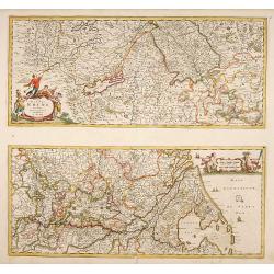
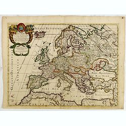
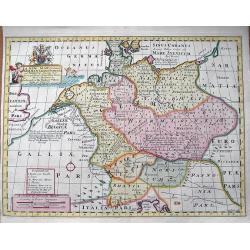
Totius Fluminis Rheni.
Two maps on one sheet each map measuring 230x530mm.
Date: Amsterdam 1680
Selling price: ????
Please login to see price!
Sold
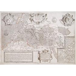
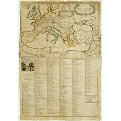
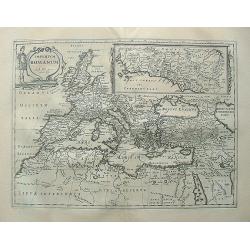
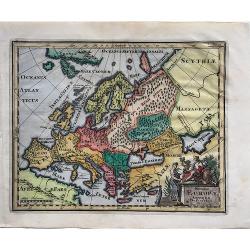
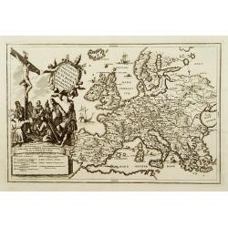
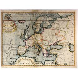
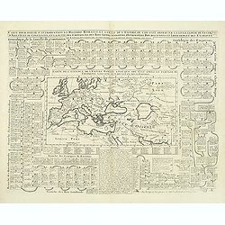
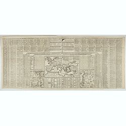
Romani Imperii Imago.
Copied after a map by Ortelius but much rarer.The medallion portraits are of Romulus and Remus -the genealogical 'tree' describes the lineage of the Roman emperors while ...
Date: Paris 1680
Selling price: ????
Please login to see price!
Sold
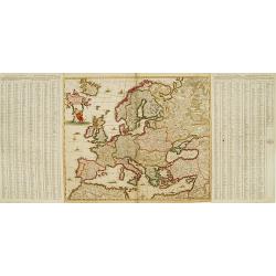
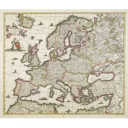
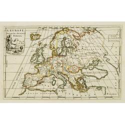
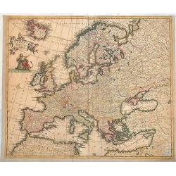
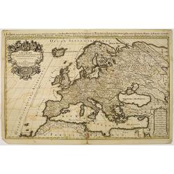
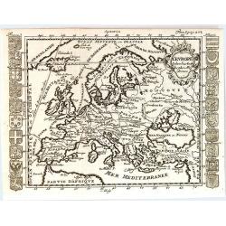
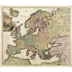
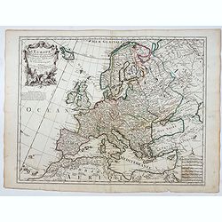
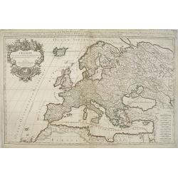
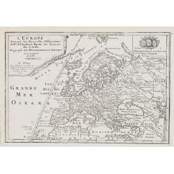
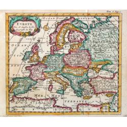
Nova et Accurate.. Europae descriptio..
One of the classic Dutch maps of Europe.On either side of the map are tables listing the Cities, keyed to the map. Lower right hand corner t' Amsterdam, By Frederick de W...
Date: Amsterdam 1680
Selling price: ????
Please login to see price!
Sold
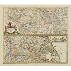
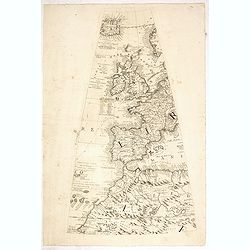
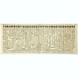
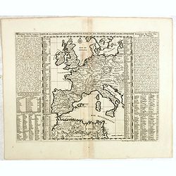
Totius Fluminis Rheni Novissima Descriptio ex officina.
Two maps on one sheet, one above the other, charting the course of the Rhine River.Beginning on the top map, from its spring at the Bodensee in Switzerland, through the e...
Date: Amsterdam, 1680
Selling price: ????
Please login to see price!
Sold in 2016
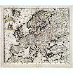
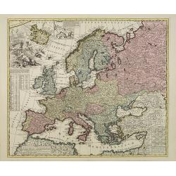
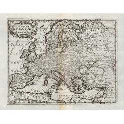
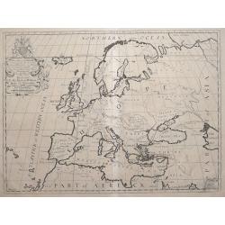
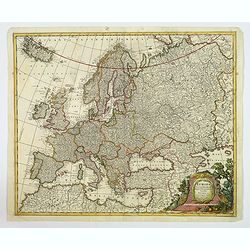
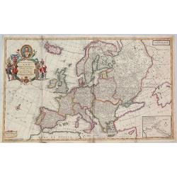
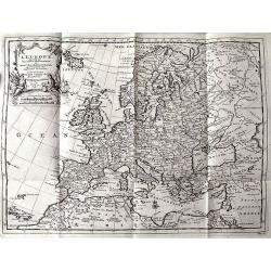
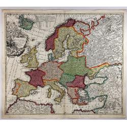
Nova et Accurata totius Europae descriptio. . .
General map of Europe richly ornamented with small compass rose and Europe shown riding Zeus in the form of a bull, and several putti holding the title banner aloft.
Date: Amsterdam, 1680
Selling price: ????
Please login to see price!
Sold in 2009
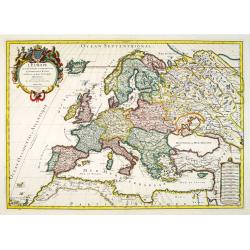
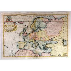
Accuratissima Europae tabula multis locis correcta. . .
Uncommon map of Europe with fine title cartouche.
Date: Amsterdam, c.1680
Selling price: ????
Please login to see price!
Sold in 2013
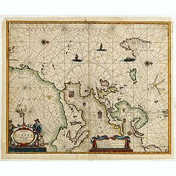
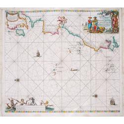
Pascaart van Europa. Alsmede een gedeelte van cust van Africa. . .
A rare chart of Europe's coastline from northern Russia to Yugoslavia in the south, also showing the West Coast of Africa as far as the Cape-Verdian islands.The uncommon ...
Date: Amsterdam, ca. 1680
Selling price: ????
Please login to see price!
Sold in 2015
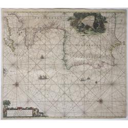
Paskaart Van Cales tot Cadix.
A nautical sea chart of South-Western Europe : part of: England, France, Portugal, Spain, from Dover/Calais to Almeria. Full title in a decorative cartouche at top right ...
Date: Amsterdam, 1681
Selling price: ????
Please login to see price!
Sold in 2021
Europe Moderne / Europe Ancienne.
Two interesting maps of Europe.
Date: Paris, 1683
Selling price: ????
Please login to see price!
Sold in 2010
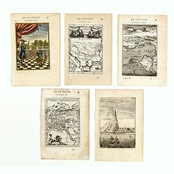
(Five engravings of European interest from Description de l\'Univers)
Finely etched prints and maps.From the French text edition of Description d'Univers.. , published in 5 volumes in 1683 by Allain Manneson Mallet (1630-1706), a well trave...
Date: Paris, 1683
Selling price: ????
Please login to see price!
Sold in 2015
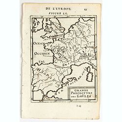
Grande Prefecture des Gavles.
A map of Europe. French text on verso.From the original 1683 text edition of "Description d'Univers. . ." by Allain Manesson Mallet (1630-1706), a well travelle...
Date: Paris, 1683
Selling price: ????
Please login to see price!
Sold in 2020
L'Europe? Dediée par sa veuve A Monseigneur Le Dauphin.
"Engraved by Liébaux. Prepared by P. Duval and published by Veuve. RARE."
Date: Paris 1684
Selling price: ????
Please login to see price!
Sold
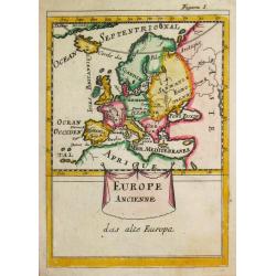
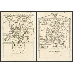
Europe Ancienne.
A map of ancient Europe from the German edition of the "Description de l' Univers".
Date: Paris, 1686
Selling price: ????
Please login to see price!
Sold
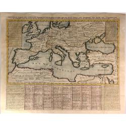
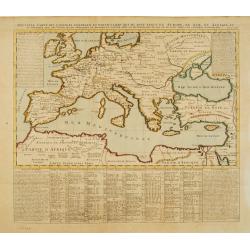
La Carte des Conciles..
From his first edition of his only folio atlas, the map is relied upon the map of his uncle, Nicolas Sanson. Engraved by I.Somer.A nice map of Europe on one sheet, and a ...
Date: Paris, 1687
Selling price: ????
Please login to see price!
Sold
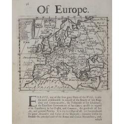
Of Europe.
Rare early English map of Europe, with a list of countries in the upper left key and a with a panel of descriptive text below.
Date: London, 1687
Selling price: ????
Please login to see price!
Sold in 2018
![[ Europe ]](/uploads/cache/30321-250x250.jpg)
[ Europe ]
Charming wood block map of Europe by the Italian XVIth and XVIIth century writer, humanist and cartographer Giuseppe Rosaccio. Taken from the 1688 Bologna "Teatro de...
Date: Bologna, Antonio Pisarri, 1594 - 1688
Selling price: ????
Please login to see price!
Sold in 2014
Romani imperi qua Oriens est descriptio geographica...
Giacomo Rossi's fine late 17th century map of the Ancient Roman Empire. Issued in Il Mercurio geografico In upper right hand corner title cartouche.The cartographer was G...
Date: Rome, 1669-1688
Selling price: ????
Please login to see price!
Sold in 2015
L'Europa...
Engraved by Giorgio Widman. Giacomo Rossi's fine late 17th century map of the European continent. Issued in Il Mercurio geografico In upper left corner a tittle cartouche...
Date: Rome, 1677-1688
Selling price: ????
Please login to see price!
Sold in 2015
L'Irlande suiant les dernieres relations..
Rare miniature map of Europe by N. de Fer, dated 1689.
Date: Paris 1689
Selling price: ????
Please login to see price!
Sold
Imperium Romanum. Auth. Phil. Briet e Societ Iesu.
From the Hornius edition of the Ancient Atlas by Janssonius. No text on verso
Date: Amsterdam, ca 1690
Selling price: ????
Please login to see price!
Sold in 2010
Carta Nova accurata del passagio et strada dalli Paesi..
Interesting road map centered on Central Europe, giving road system from Low Countries, Germany, Austria to Rome (Italy).More about post road maps maps. [+]
Date: Amsterdam, 1690
Selling price: ????
Please login to see price!
Sold in 2021
Accuratissima Europae tabula.
Scarce map of Europe by Danckerts. Full original colors.
Date: Amsterdam, 1690
Selling price: ????
Please login to see price!
Sold in 2013
Nieuwe Paskaert Vande Gehele Westersche Scheep-vaert.
Johannes van Keulen was the founder of the successful van Keulen firm that published charts, pilot guides, and sea atlases for over 2 centuries. In 1680 he published his ...
Date: Amsterdam, c. 1690
Selling price: ????
Please login to see price!
Sold in 2018

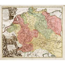
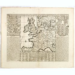
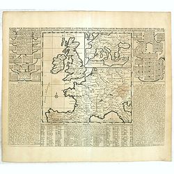
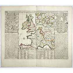
Neueste Beschreibung des ganzen Rheinstroms...
Rare large map illustrating the course of the Rhine river. The map is surrounded by 20 city plans, including Cologne, Bonn, Speyer, Mainz, Heidelberg, Worms, Basel, Stras...
Date: Nuremberg, 1690
Selling price: ????
Please login to see price!
Sold in 2015
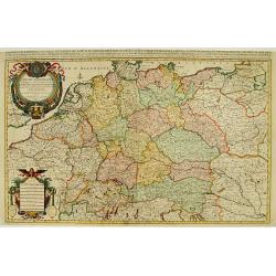
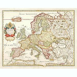
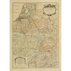
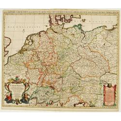
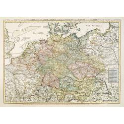
L'Empire d'Allemagne ..
Large scale map of Germany, The Netherlands, Belgium, Luxemburg, Poland and Austria. Prepared by Sanson and published by Jaillot.Very large and decorative piece.
Date: Paris 1692
Selling price: ????
Please login to see price!
Sold
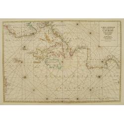
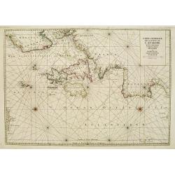
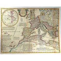
Carte générale des costes de l'Europe sur l'Ocean comprises depuis Dronthem en Norvege jusques au Detroit de Gibraltar.
From the first edition of Mortier's Atlas Maritime, showing the coasts of Western Europe.From Mortier's Neptune François , one of the most spectacular cartographical wor...
Date: Amsterdam 1693
Selling price: ????
Please login to see price!
Sold
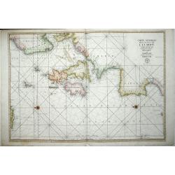
Carte generale des costes de L'Europe sur l'Ocean comprises depuis Dronthem en Norvege jusques au Destroit de Gibraltar.
This general chart of the coast of Western Europe extends from the region west of Tronheim, Norway to about where Casablanca is on the coast of North Africa. It includes ...
Date: Paris 1693
Selling price: ????
Please login to see price!
Sold
Carte generale des costes de l\'Europe sur l\'Ocean comprises depuis Dronthem en Norvege jusques au Destroit de Gibraltar.
An important sea chart of the Atlantic coasts of Europe, from Trondheim in Norway to the Straits of Gibraltar and the British Isles.The title at upper right is accompanie...
Date: Paris 1693
Selling price: ????
Please login to see price!
Sold in 2012
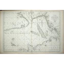
Carte de la Mer D\'Allemagne Contentant les Bancs Isles et Coftes Comprifes depuis Bergen et les Isles Schetland jufques au Pas de Calais.
A large chart of the North Sea showing the coastlines of eastern Britain and parts of Norway, Denmark, Germany and the Netherlands. North is oriented to the left of the p...
Date: Paris, 1693
Selling price: ????
Please login to see price!
Sold in 2012
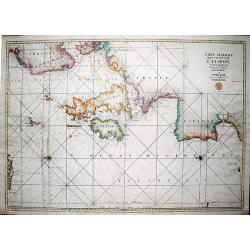
Carte generale des costes de l'Europe sur l'Ocean comprises depuis Dronthem en Norvege jusques au Destroit de Gibraltar.
A very large, decorative, and important sea chart of the Atlantic coasts of Europe, from Trondheim in Norway to the Straits of Gibraltar and the British Isles. The title ...
Date: Paris, 1693
Selling price: ????
Please login to see price!
Sold in 2019
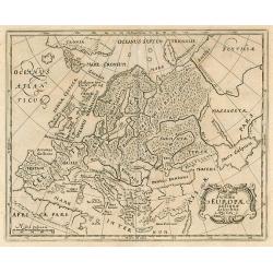
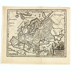
Summa Europae antique descriptio.
Small historical map of Europe.
Date: Wolfenbuttel, 1694
Selling price: ????
Please login to see price!
Sold in 2010
![[Coronelli's 2 sheet map of Europe] Parte Occidentale dell' Europa? / Parte orientale dell' Europa . . .](/uploads/cache/29154-250x250.jpg)
[Coronelli's 2 sheet map of Europe] Parte Occidentale dell' Europa? / Parte orientale dell' Europa . . .
Fine map of Europe including Russia, Ukraine and the Caspian Sea, and includes 2 decorative cartouches with dedication to Giovanni da Mula. The coast of North America in ...
Date: Venice, 1695
Selling price: ????
Please login to see price!
Sold in 2012
L'Europe divisee suivant l'estendue de ses principaux estats. . .
Fine map of Europe with a decorative title and scale cartouche.Alexis-Hubert Jaillot (1632-1712), was a French cartographer. He joined the Sanson heirs and redrew Nicolas...
Date: Amsterdam, 1696
Selling price: ????
Please login to see price!
Sold
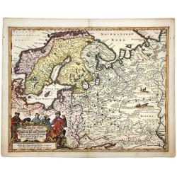
Land und see charter Schleswig vist nach Muctau. . .
An attractive and detailed map of north east Europe, with Scandinavia and part of Russia. With a striking cartouche of Merchants and Traders in local costume. Adam Oleari...
Date: Hamburg, 1696
Selling price: ????
Please login to see price!
Sold in 2020
![[Lot of two maps of Europe]](/uploads/cache/19546-(1)-250x250.jpg)
[Lot of two maps of Europe]
An attractive large-format map of the European continent, embellished with a large title-cartouche. Newly engraved for the counterfeited edition of the ' Atlas Nouvea...
Date: Amsterdam, 1696
Selling price: ????
Please login to see price!
Sold in 2022
![Parte Occidentale dell' Europa,... [together with] Parte Orientale dell' Europa,...](/uploads/cache/91022-250x250.jpg)
Parte Occidentale dell' Europa,... [together with] Parte Orientale dell' Europa,...
Coronelli's double sheet map of Europe, from Atlante Veneto. Decorated with all manner of flora and fauna.
Date: Venice, 1690 - 1697
Selling price: ????
Please login to see price!
Sold in 2010
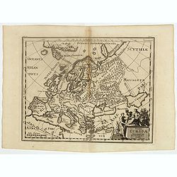
Summa Europae Antiquae descriptio.
Interesting map of Ancient Europe from Philipp Clüver's famous Introductionis in Universam geographicam, first published in Leiden in 1624. Philipp Clüver (1580–1623)...
Date: Amsterdam, 1697
Selling price: ????
Please login to see price!
Sold in 2018
Summa Europae Antiquae descriptio.
A fascinating small map of Ancient Europe from Philipp Clüver's famous "Introductionis in Universam geographicam", which was first published in Leiden in 1624....
Date: Amsterdam, 1697
Selling price: ????
Please login to see price!
Sold in 2022
Globe gore with West Europe and Morocco.
Half-gore from his 110 centimeters in diameter globe of 1688 with part of West Europe, including England, Iceland, Netherlands, Belgium, France, Spain and Portugal. Moroc...
Date: Venice, 1696/1699
Selling price: ????
Please login to see price!
Sold in 2015
L'Europe Selon les Auth les Plus Modernes.
A rare map of Europe by Matthieu Ogier, published in Lyon in 1699. The map spans from Portugal to the eastern edge of the Mediterranean Sea and from Northern Africa to Gr...
Date: Lyon, 1699
Selling price: ????
Please login to see price!
Sold in 2016
Europae in Tabula Geographica Delineatio. . .
Uncommon map of Europe with fine title cartouche and key to longitude and latitude of the most import cities.
Date: Amsterdam, 1700
Selling price: ????
Please login to see price!
Sold in 2013
A New Map of Antient Germany, Rhaetia, Vindelicia, and Noricum...
Interesting map of central Europe during ancient times. Extending from Denmark to northern Italy. Includes Germany, the Netherlands, Poland, Austria,... From "A N...
Date: Oxford, c1700
Selling price: ????
Please login to see price!
Sold in 2013
Accuratissima Europae tabula multis locis correcta. . .
Uncommon map of Europe with fine title cartouche, likely after a design by Philip Tideman.
Date: Amsterdam, c.1700
Selling price: ????
Please login to see price!
Sold in 2011
Europe.
General map of Europe. From Description de tout l'Univers, published by François Halma.
Date: Amsterdam, 1700
Selling price: ????
Please login to see price!
Sold in 2011
L\'Europe divisée suivant l\'estendue de ses principaux Estats...
Fine map of Europe, engraved by Cordier. With date "1695" in manuscript.
Date: Paris, c. 1700
Selling price: ????
Please login to see price!
Sold in 2013
![L'Europa dedicata All'Illustris ed Eccel. Mo Sig.re D.Giovanni Milano... [Part of a wall map]](/uploads/cache/41454-250x250.jpg)
L'Europa dedicata All'Illustris ed Eccel. Mo Sig.re D.Giovanni Milano... [Part of a wall map]
Upper left sheet of a 4 sheet wall map of Europe. Published by Paolo Petrini. Petrini's maps are considered great rarities and are highly collectable.The map is centered ...
Date: Naples, 1700
Selling price: ????
Please login to see price!
Sold in 2018
Carte de l'Europe Dressée sur les observations de Mrs de l'Academie Royale des Sciences . . .
An early and scarce state of "L’Europe. Chez l’Auteur sur le Quai de l’Horloge a la Couronne de Diamans, 1700".The finely engraved map shows Europe divide...
Date: Paris, 1700
Selling price: ????
Please login to see price!
Sold in 2025
Status religionis catholicae in Europa per mappam geographicam proposito.
A map from the series of maps by the Jesuit mathematician. A general map of Europe, produced by Scherer to show the spread of Catholicism in the continent. There are 2 sh...
Date: Munich c.1702
Selling price: ????
Please login to see price!
Sold
A New Map of Europe, According to the Present General Divisions, and Names of its Countries together with their Capital Cities Chief Rivers Mountains &c.
Drawn by Edward Wells engraved by M. Burg. An attractive and decorative early map of Europe from the beginning of the 18th Century. This map was part of an atlas dedicat...
Date: London, 1704
Selling price: ????
Please login to see price!
Sold in 2016
A New Map of Europe, According to the Present General Divisions, and Names of its Countries together with their Capital Cities Chief Rivers Mountains &c..
Drawn by Edward Wells engraved by M. Burg. An attractive and decorative early map of Europe from the beginning of the 18th Century. This map was part of an atlas dedicate...
Date: London, 1704
Selling price: ????
Please login to see price!
Sold in 2015
A New Map of Europe According to its Ancient General Divisions and Names of its Countries together with Their Chief Cities, Rivers, Mountains & c. Dedicated to his Highness, William, Duke of Gloucester
Drawn by Edward Wells and engraved by M. Burg. An attractive and decorative early map of Europe from the beginning of the 18th Century.This map was part of an atlas dedic...
Date: London, 1704
Selling price: ????
Please login to see price!
Sold in 2015
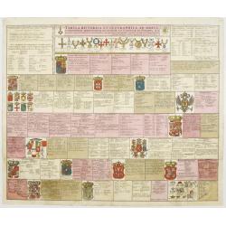
Tabula Historica et Geographica ad breve compendium..
An attractive instructional plate showing the coats-of-arms of various European countries, each with extensive key.
Date: Amsterdam, 1705
Selling price: ????
Please login to see price!
Sold
Theatrum Historicum ad annum Christi quadringentesimu in quo tu Imperii Romani tu Barbarorum...
A splendid map of the Roman Empire, showing its extent in 400 AD, covering most of North Africa, Southern Europe, and Britain as far as the Antonine Wall in Scotland. Ins...
Date: Paris, 1705
Selling price: ????
Please login to see price!
Sold in 2016
Europa Pars tenet Haec Mundi. . .
A nice, attractive map of the continent of Europe by G & L Valk of Amsterdam. The differing regions are colored in outline. Good map detail shown, and set off by a wo...
Date: Amsterdam, ca 1705
Selling price: ????
Please login to see price!
Sold in 2023
L'Europe divisee suivant l'estendue de ses principaux estats. . .
Fine map of Europe with a decorative title and scale cartouche. Prepared by Nicolas Sanson.Published by Alexis-Hubert Jaillot (1632-1712), who was a French cartographer. ...
Date: Paris, 1706
Selling price: ????
Please login to see price!
Sold in 2011
To Her Most Sacred Majesty Ann, Queen of Great Britain, France and Ireland, This Map of Europe. . .
A striking large format map of Europe, published by Herman Moll in his "New and Compleat Atlas", first published in 1708. This is from the early edition bearing...
Date: London, 1708
Selling price: ????
Please login to see price!
Sold in 2018
Le Cours de la Riviere du Rhein depuis sa Sources jusques a son Emboucheure ou sont distingues Tous les Etats et Souverainetes?
Handsome map detailing the course of the Rhine River, from its source in Switzerland, through Germany to its mouth on the North Sea, in the Netherlands. Also shows part o...
Date: Paris, 1709
Selling price: ????
Please login to see price!
Sold in 2016
Hydrographia Germaniae..
Showing the river system of western Europe. Upper and lower left corner splendid title cartouches with Neptune and other mythological figures.The map is painted in strong...
Date: Nurenberg 1710
Selling price: ????
Please login to see price!
Sold
Novi Imperii Germanici ? L'Allemagne Dressé sur les observations ..
Fine map of Germany, Low countries, Switzerland, Austria and Poland. Pierre Mortier copied the map of Nicolas Sanson and de L'Isle. Sanson was to bring about the rise of ...
Date: Amsterdam, 1710
Selling price: ????
Please login to see price!
Sold in 2008
Summa Europae Antique Descriptio.
Striking and decorative map of Europe, with an ornate cartouche. Nice dark impression. From Cluverius' "Introductio in Universam Geographiam" (first issued in 1...
Date: London, 1711
Selling price: ????
Please login to see price!
Sold in 2023
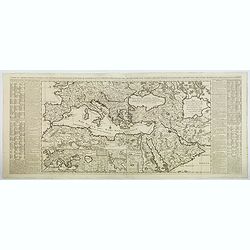
Carte de L'Empire Othoman Consideree dans les Etats de Cette Puissance. . .
This lovely, large map shows the extent of the Ottoman Empire, complete with comparisons to the earlier Empires of Alexander the Great and the Romans. It covers the Medit...
Date: Amsterdam, 1714
Selling price: ????
Please login to see price!
Sold in 2020
L'EUROPE suivant les Nouvelles Observations...
Charming map of Europe, including parts of North Africa, the Near East, and Russia. Very detailed map with many place names (cities, rivers, lakes, islands, etc). Decorat...
Date: Leiden, c.1715
Selling price: ????
Please login to see price!
Sold in 2011
L'Europe, Suivant les Nouvelles Observations de M.rs de L'Academie Royale des Siences. . .
The map was published by N. de Fer (1646-1720), Geographe du Roy, and shows in great evidence the Meridian Line choose by French cartographers in 1634 as framework for th...
Date: Paris, 1717
Selling price: ????
Please login to see price!
Sold in 2018
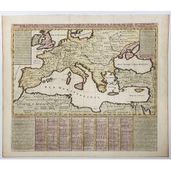
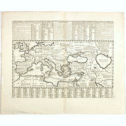
Nouvelle Carte des Conciles Generaux et Particuliers qui se sont Tenus en Europe...
A fine map of the lands bordering the Mediterranean Sea, including Most of Europe, North Africa & Western Asia.The map was drawn to show the cities where Ecclesial Co...
Date: Paris, 1718
Selling price: ????
Please login to see price!
Sold in 2016
Nouvella Carte des Conciles Generaux et Particuliers qui se sont tenus en Europe, en Asie, En Afrique etc. . .
A fine map of the lands bordering the Mediterranean Sea, including Most of Europe, North Africa & Western Asia. The map was drawn to show the cities where Ecclesial C...
Date: Paris, 1718
Selling price: ????
Please login to see price!
Sold in 2020
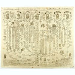
Genealogie des Familles souverains de l'Europe issues par alliance de la maison de France . . .
Fine example of Chatelain's attractive plate showing the genealogy of the important royal families of Europe, decorated with coats-of-arms. Zacharie Chatelain (d.1723) wa...
Date: Amsterdam, 1719
Selling price: ????
Please login to see price!
Sold in 2018
Nouvelle carte genealogique des principaux souverains de l'Europe issus de la Famille Roiale de France . . .
Fine example of Chatelain's attractive plate showing the genealogy of the important royal families of Europe, decorated with coats-of-arms. Zacharie Chatelain (d.1723) wa...
Date: Amsterdam, 1719
Selling price: ????
Please login to see price!
Sold in 2018
Routes des postes et des voitures pour les marchandises et pour les voyages . . .
Uncommon post route map and commercial roads of Germany, the Low Countries, Pologne, Switzerland, Austria, and Northern Italy, published by the well-known map makers and ...
Date: Amsterdam, 1720
Selling price: ????
Please login to see price!
Sold in 2014
Carte pour servir d'introduction à l'histoire romaine . . .
Map of the ancient Roman Empire. This impressive engraving is a wonderful example of Chatelain’s elegant plates from his "Atlas Historique, Ou Nouvelle Introductio...
Date: Amsterdam, ca. 1720
Selling price: ????
Please login to see price!
Sold in 2012
![[. . .] ur servir d'introduction à l'histoire Romaine et à celle de l'Empire, ou l'on fait observer la genealogie de cr [. . .]](/uploads/cache/34429-250x250.jpg)
[. . .] ur servir d'introduction à l'histoire Romaine et à celle de l'Empire, ou l'on fait observer la genealogie de cr [. . .]
A striking and highly detailed copper engraved plate with a map of the ancient Roman Empire, including Europe as far east as the Black Sea. Including descriptive text pan...
Date: Amsterdam, 1720
Selling price: ????
Please login to see price!
Sold in 2014
Carte historique chronologique et géographique de l'empire romain où l'on fait observer son étendue et diverses remarques pour l'intelligence de l'histoire.
Interesting sheet with a map of the Roman Empire, with descriptive French text, from Chatelain's monumental 7-volume "Atlas Historique". In upper right margin: ...
Date: Amsterdam, 1720
Selling price: ????
Please login to see price!
Sold in 2017
Carte de la Germanie et les différents états où ses peuples ont porté leurs conquètes.
Interesting sheet with a map of Europe, with descriptive French text, from Chatelain's monumental 7-volume "Atlas Historique". In upper right margin: 'Tome 2, N...
Date: Amsterdam, 1720
Selling price: ????
Please login to see price!
Sold in 2014
Carte pour l'itelligence de l'histoire dAngleterre où on remarque les conquètes de cette monarchie dans la plupart des états de l'europe, les droits sur lesquels sont fondées ses prétentions sur la monarchie française ou sur divers états...
Interesting sheet with historical and genealogical copper engraving, extracted from the historical atlas: introduction to the history, chronology, ancient and modern geog...
Date: Amsterdam, 1720
Selling price: ????
Please login to see price!
Sold in 2021
Carte pour l'intelligence de l'Histoire d'Angleterre où on remarque les conquêtes de cette monarchie dans la plupart des états de l'Europe, les droits sur lesquels sont fondées ses prétentions sur la monarchie sur divers états qui lui ont été...
Interesting sheet with an old map, historical and genealogical copper engraving, extracted from the historical atlas: introduction to the history, chronology, ancient and...
Date: Amsterdam, 1720
Selling price: ????
Please login to see price!
Sold in 2015
Carte pour l'itelligence de l'histoire dAngleterre où on remarque les conquètes de cette monarchie dans la plupart des états de l'europe, les droits sur lesquels sont fondées ses prétentions sur la monarchie française ou sur divers états...
Two maps on one sheet surrounded by historical and genealogical information to the history, chronology, ancient and modern geography, genealogy of the royal houses of Eur...
Date: Amsterdam, 1720
Selling price: ????
Please login to see price!
Sold in 2019
Europa Christiani Orbis Domina In Sua Imperia, Regna et Status. . .
An attractive Homann map of Europe. It is detailed, showing individual mountains and trees. The large (uncolored) title cartouche features "Europa"- surrounded ...
Date: Nuremberg, 1720
Selling price: ????
Please login to see price!
Sold in 2018
Carte pour servir a l'intelleigence de l'Histoire Eclesiastique et a faire connoitre les persecutions de l'Eglise. . .
Map depicting Egypt and area around the Nile, Ancient world and finally Syria and the coast of Armenian Turkey down through Holy Land and Arabia Desert. Extensive histori...
Date: Amsterdam, 1720
Selling price: ????
Please login to see price!
Sold in 2023
Nouvelle carte des conciles generaux et particuliers ..
Very handsome map of the lands bordering the Mediterranean Sea, including Great Britain and the Black Sea. The map was drawn to show the cities, & towns where Ecclesi...
Date: Amsterdam 1721
Selling price: ????
Please login to see price!
Sold
Europe.
A nice little map of the European continent.
Date: Amsterdam, 1721
Selling price: ????
Please login to see price!
Sold
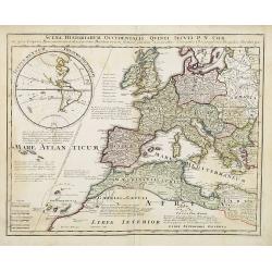
Scena Historiarum Occidentalis Quinti Seculi P.N. CHR.
A very striking map of Europe. Decorated with a hemisphere of North and South America, annotated with various commentaries in Latin.
Date: Nuremberg, ca 1725
Selling price: ????
Please login to see price!
Sold in 2008
