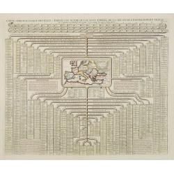
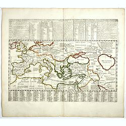
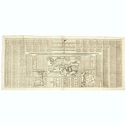
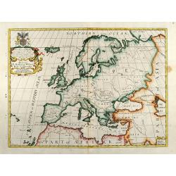
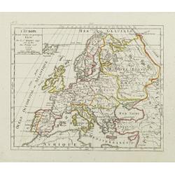
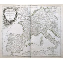
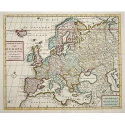
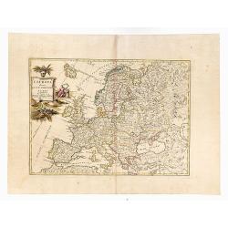
Carte chronologique des etats et empires du monde, qui se sont former de la chute de l'empire romain, depuis le commencement de . . .? vulgaire, jusqu'a present. . .
Extremely interesting sheet with a small map of Europe at center and chronological tables in French tracing the ancestry of the royal houses of Europe. From: Atlas Histor...
Date: Amsterdam, 1728
Selling price: ????
Please login to see price!
Sold in 2008
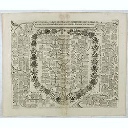
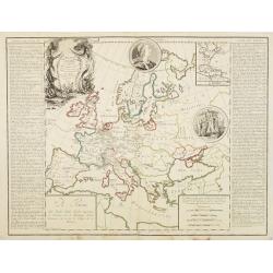
Carte Genealogique Des Maisons Imperialles Depuis Charles-Magne...
Fascinating genealogical tree, showing the lineage of Charlemagne through the modern era, including the ruling families of Astria, Spain, Suabe, Germany, Saxony, and Luxe...
Date: Amsterdam, 1728
Selling price: ????
Please login to see price!
Sold in 2016
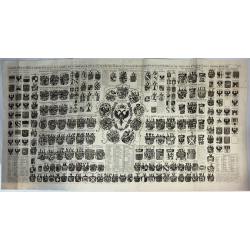
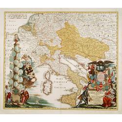
Carte Heraldique Representant Les Armes De L' Empereur Des Electeurs Des Princes Tant Ecclesiastiques Que Seculiers Et De Tous Les Etats Du Saint Empire Romain
A magnificent large copper engraved chart, illustrating the coats of arms of the Emperor, Electors and Princes of the Holy Roman Empire. At its centre is the fantastic ar...
Date: Amsterdam, 1728
Selling price: ????
Please login to see price!
Sold in 2018
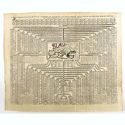
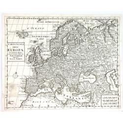
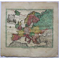
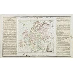
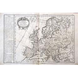
Carte chronologique des etats et empires du monde, qui se sont former de la chute de l'empire romain, depuis le commencement de . . .? Vulgaire, jusqu'a present. . .
Extremely interesting sheet with a small map of the Roman Empire at center. Published by Henri Abraham Chatelain (1684 – 1743) who was a Huguenot pastor of Parisian ori...
Date: Amsterdam, 1728
Selling price: ????
Please login to see price!
Sold in 2020
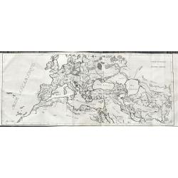
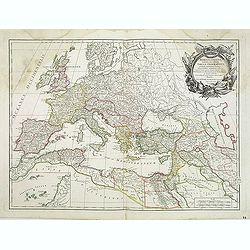
Carte historique cronologique de l'empire Romain ou l'on fait observer son etendue et diverses remarques pour l'intelligence de l'histoire . . .
In the center a map (207 x 446mm.) of the extent of the Roman Empire (Europe and the Middle East). Above and below extensive explanatory notes. Shown is the track of Juli...
Date: Amsterdam, 1728
Selling price: ????
Please login to see price!
Sold in 2018
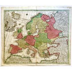
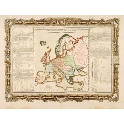
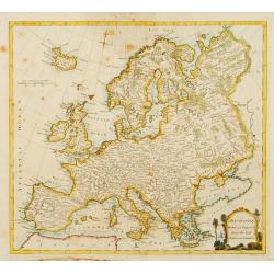
Europa Religionis Christianae. . .
A superb 18th century original hand colored regional map of Europe with a spectacular cartouche featuring religious and allegorical figures signifying Christianity as a m...
Date: Augsburg, 1728
Selling price: ????
Please login to see price!
Sold in 2019
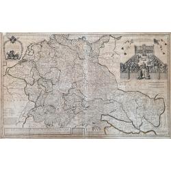
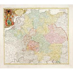
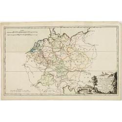
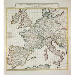
Methode Pour Etudier L'Histoire.
A striking map of Germany, from “METHODE POUR ETUDIER L’HISTOIRE” by L’Abbe Lenglet du Fresnoy, published in Paris in 1729. The map is quite rare and is not now o...
Date: Paris, 1729
Selling price: ????
Please login to see price!
Sold in 2021
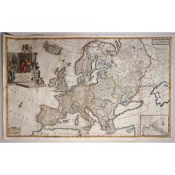
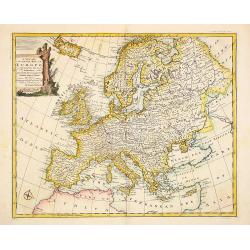
To Her Most Sacred Majesty Carolina Queen of Great Britain, France and Ireland, This Map of Europe According to the Newest and most Exact Observations is most Humbly Dedicated by your Majesty's most Obe
This edition was published by J. Bowles, T. Bowles, P. Overton, J. King, in London c.1730. Two sheets conjoined, total 595 x 975mm. Moll's large format map of Europe, ded...
Date: London, 1730
Selling price: ????
Please login to see price!
Sold in 2017
![Nieuwe wassende grade paskaart, vertoonde t. westerlykste deel der zee kusten van Europa : strekkende van Hitland, of Ysland, tot Vooby t'Naauw van de straat waar in ook vervangen syn, d'Carnarise en Vlaamse Eyan[d] seer dienstif](/uploads/cache/97799-250x250.jpg)
Nieuwe wassende grade paskaart, vertoonde t. westerlykste deel der zee kusten van Europa : strekkende van Hitland, of Ysland, tot Vooby t'Naauw van de straat waar in ook vervangen syn, d'Carnarise en Vlaamse Eyan[d] seer dienstif
An impressive large sea chart of the north Atlantic, extending from Iceland to the Canary islands. It depicts part of North Africa, Spain, Portugal, France, UK, Ireland, ...
Date: Amsterdam, 1730
Selling price: ????
Please login to see price!
Sold in 2016
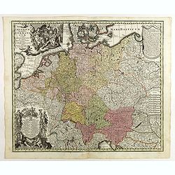
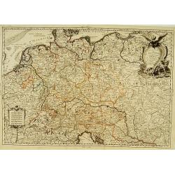
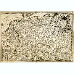
Imperium Romano Germanicum . . .
Map of central Europe centered on Germany, but including Poland, the Low Countries, Switzerland, Austria, etc. No text on verso. Very good impression done on thick paper....
Date: Ausburg, 1730
Selling price: ????
Please login to see price!
Sold in 2017
A New Map of Germany, Hungary, Transilvania...
Large scale map of central Europe from Moll, published J. & T. Bowles, P. Overton & J. King. Shows the area within Danzig, Denmark, Paris, Venice, Trieste, Pragu...
Date: London, ca. 1730
Selling price: ????
Please login to see price!
Sold in 2023
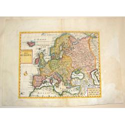
Carte pour servir à l'intelligence de l'histoire eclessiastique et a faire connoitre les persecutions de l'Eglise . . .
Two sheet engraving explaining the various religious divisions in Europe. In the center a map (210 x 350mm.) of Europe and Turkey. To the lower left a map of Egypt and to...
Date: Amsterdam, 1720-1732
Selling price: ????
Please login to see price!
Sold in 2017
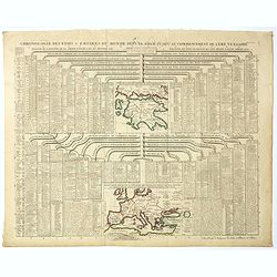
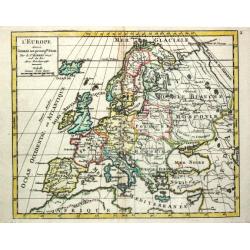
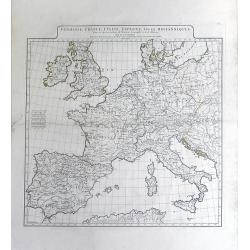
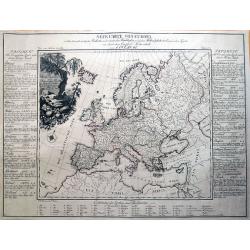
Chronologie des Etats & Empires du Monde depuis Adam jusqu'au au Commencement de l'Ere Vulgaire.
Graving showing the timeline of earth history from Adam to the beginning of the birth of Christ with inlay map of Peloponnese (120x130mm.) and in bottom Europe in the Bro...
Date: Amsterdam, 1720-1732
Selling price: ????
Please login to see price!
Sold in 2017
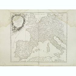
Carte Generale de L'Empire Romain.
Large and rare map of the Roman Empire. It shows the area from the Canary Islands until the Indus river. Including regions, some city names, lakes, rivers, and so on.Publ...
Date: Paris, 1734
Selling price: ????
Please login to see price!
Sold in 2021
L\'Allemagne et ses Frontières, comprenant le théatre de la Guerre..
An uncommon map of Germany, including, Poland, Low Countries, Switzerland, Austria and Northern part of Italy.
Date: Paris, 1735
Selling price: ????
Please login to see price!
Sold in 2008
To His Royal Highness Frederick Lewis, Prince of Wales and Earl of Chester, Electoral Prince of Brunswick, This Map of Europe ...
This highly decorative large-format map of Europe was after the map originally published by John Senex in London in 1708. However, this special edition was published b...
Date: Dublin, ca. 1735
Selling price: ????
Please login to see price!
Sold in 2020
L'Allemagne et ses frontieres comprenant le theatre de la guerre. . .
A scarce map of Germany, Poland, The Low Countries, Switzerland, Austria, Northern Italy, etc. showing the Theater of War in the Holy Roman Empire.
Date: Paris, 1737
Selling price: ????
Please login to see price!
Sold in 2014
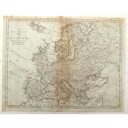
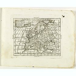
A New Map of Europe according to the Present General Divisions and Names
Decorative colored map of the European continent. From "A New Sett of Maps both of Antient and Present Geography" by Edward Wells an English clergyman, teacher...
Date: London, 1738
Selling price: ????
Please login to see price!
Sold in 2009
Carta Nuova Dell' Europa....
Map taken from "Atlas Novissimo" published by Giambattista Albrizzi in 1738. Later included in the "History of all peoples of the world" published in ...
Date: Venice, 1738
Selling price: ????
Please login to see price!
Sold in 2016
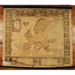
L'Europe dressé sur les nouvelles..
Separataly published: very scarce. A decorative wall map embellished by 30 panel vignettes illustrating episodes in the history of Europe. Many of the vignettes have exce...
Date: Paris 1740
Selling price: ????
Please login to see price!
Sold
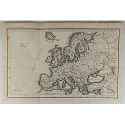
Nieuwe Kaart van Europa.
A map of Europe from a Dutch pocket-atlas.
Date: Amsterdam/ Deventer, 1742
Selling price: ????
Please login to see price!
Sold
Nieuwe Kaart van Europa.
Attractive and uncommon map of Europe. From Atlas Portatif. RARE.
Date: Amsterdam/ Deventer, 1742
Selling price: ????
Please login to see price!
Sold in 2009
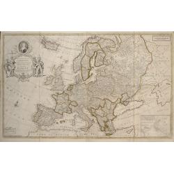
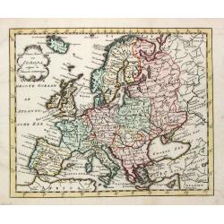
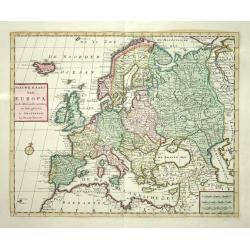
Europa Secundum Legitimas Projectionis Stereographicae Regulas et juxta recentissimas observationes ?
Johann Baptist Homann's well-engraved map of Europe. An ornate title cartouche with puti presenting gifts to a Queen.Johann Baptist Homann (1663-1724) was a German engrav...
Date: Nuremberg 1743
Selling price: ????
Please login to see price!
Sold in 2009

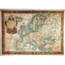
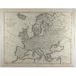
L'EUROPE.
An elegant map of Europe with a large amount of topographical and settlement detail provided. It is based upon Haas' stereographic horizontal projection. A very large dec...
Date: Nuremberg, 1743
Selling price: ????
Please login to see price!
Sold in 2019
Europa Secundum Legitimas Projectionis Stereographicae Regulas et juxta recentissimas observationes. . .
Johann Baptist Homann's well-engraved map of Europe has a large decorative cartouche. Johann Baptist Homann (1663-1724) was a German engraver and publisher, who establish...
Date: Nuremberg, 1744
Selling price: ????
Please login to see price!
Sold in 2011
Carte d'Europe Dressée pour l'Usage du ROY..
Beautifully engraved map of Europe. Detailed to show towns, roads, rivers, lakes, counties, etc. Embellished with a decorative title cartouche surmounted by the French cr...
Date: Amsterdam c. 1745
Selling price: ????
Please login to see price!
Sold
Novae Europae Delineatio.​
A decorative old colored copper engraved map by Peter Conrad Monath. This interesting map shows the continent of Europe with the Christian countries of Scandinavia, Great...
Date: London, 1746
Selling price: ????
Please login to see price!
Sold in 2018
Imperii Romano Germanici..
Johann Baptist Homann's well-engraved map of the Roman Empire with a large decorative cartouche.
Date: Nuremberg, 1747
Selling price: ????
Please login to see price!
Sold
A new and very accurate map of Europe..
General map of Europe, with an elegant baroque title cartouche. Engraved by Emanuel Bowen. In lower left corner, plate number 36.
Date: London 1747
Selling price: ????
Please login to see price!
Sold
L' Europe.
Gilles Robert de Vaugondy (!686-1766) and son Didier (1723-86), Paris geographers and publishers. Gilles succeedded Pierre Moulart Sanson in 1730. ' Atlas Portatif', 1748...
Date: Paris, 1748
Selling price: ????
Please login to see price!
Sold
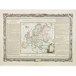
L'Europe. Divisée suivant ses principaux Etats.
Nice small map of Europe, dated 1748. From Atlas Portatif Universel, by Robert de Vaugondy.Page 3 outside border top left.
Date: Paris, ca.1748
Selling price: ????
Please login to see price!
Sold
Théatre historique géographique et chronologique du règne de Louis XV Dit le Bien-Aimé. Dedié et présenté au Roy. . .
Uncommon issue of this decorative map showing the Empire of Louis XV (1715-1774). In upper right corner an inset map of the east coast of America, indicating the French p...
Date: Paris, 1749
Selling price: ????
Please login to see price!
Sold in 2008
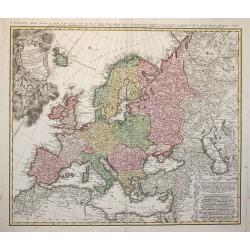
Tabula Geographica Europae Austriacae generalis..
Johann Baptist Homann's well-engraved map has a large decorative cartouche at bottom right and left showing a throned ruler, showing the Austrian possessions in Europe.
Date: Nuremberg 1750
Selling price: ????
Please login to see price!
Sold
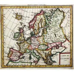
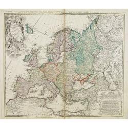
Carte de l'' Europe.
A small map of the European continent.
Date: paris, c. 1750
Selling price: ????
Please login to see price!
Sold in 2008
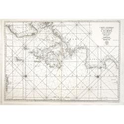
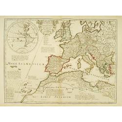
Carte générale des costes de l'Europe sur l'Ocean comprises depuis Dronthem en Norvege jusques au Detroit de Gibraltar.
General chart of the Atlantic coasts of Europe, from Trondheim in Norway to the Straits of Gibraltar. Prepared by Nicolas Bellin and engraved by H. van Loon.
Date: Paris, 1750
Selling price: ????
Please login to see price!
Sold in 2013
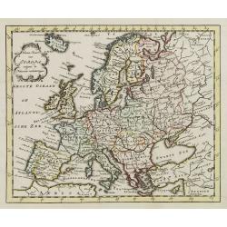
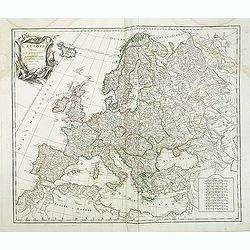
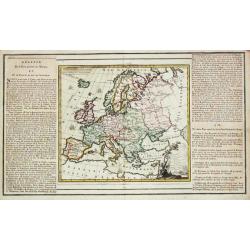
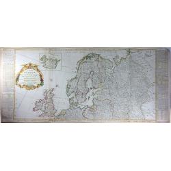
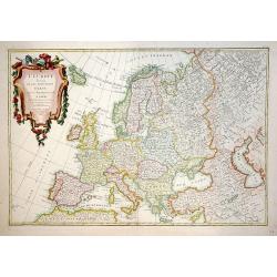
Tabula Geographica Europae. . .
Interesting map in four sheets, forming a map of Europe, including good detail on Scandinavia, Russia, Poland with a decorative title cartouche, and a Prussian duty stamp...
Date: Berlin, ca. 1750
Selling price: ????
Please login to see price!
Sold in 2017
Tab. IV Imperii Francici vel Romano German f. Romani Occid . . .
Uncommon map and table depicting the divisions of Europe, during the reign of the Holy Roman Emperor Charles V.
Date: Nuremberg / 1750
Selling price: ????
Please login to see price!
Sold in 2017
L'Europe divisée en ses principaux Etats?
A detailed map from the Atlas Universel. The map is precisely engraved and not given to the fanciful cartography being promoted by many of the other contemporary French t...
Date: Paris, 1751
Selling price: ????
Please login to see price!
Sold in 2009
Romani Imperii occidentalis . . .
Striking and highly detailed map of the Roman Empire, extending from the British Isles to North Africa, the Black Sea, Caspian Sea and Persian Gulf. From his "Atlas ...
Date: Paris, 1752
Selling price: ????
Please login to see price!
Sold in 2011
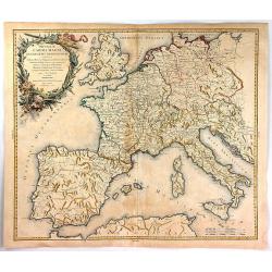
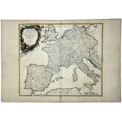
Imperium Caroli Magni Occidentis Imperatoris. . .
Attractive and detailed map of Charlemagne's empire, covering the British Isles, Denmark, the Low Countries, Germany, France, Spain, Switzerland, Austria, Italy, Hungary,...
Date: Paris, 1752
Selling price: ????
Please login to see price!
Sold in 2011
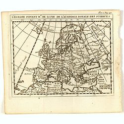
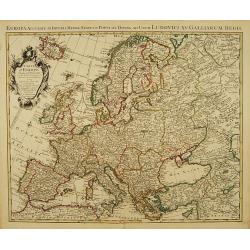
L'Europe suivant Mr. De Lisle de L'Academie Royale des Scienes.
Scarce small map of Europe based on cartography of Guillaume Delisle (. Published in "Nouveau traité de geographie par M**** ", published by La veuve Lottin &a...
Date: Paris, 1752
Selling price: ????
Please login to see price!
Sold in 2017
Imperium Caroli Magni Occidentis Imperations.
A pleasing map of Europe and the Empire of Charlemagne by Vaugondy. It covers Europe and the European Empire of Charles the Great from England south as far as northern Af...
Date: Paris, 1752
Selling price: ????
Please login to see price!
Sold in 2018
Imperium CAROLIMAGNI Occidentis Imperatoris.
An attractive and detailed map of Charlemagne's empire, covering the British Isles, Denmark, the Low Countries, Germany, France, Spain, Switzerland, Austria, Italy, Hunga...
Date: Paris, 1752
Selling price: ????
Please login to see price!
Sold in 2020
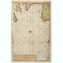
(Untitled sea chart of the North Sea with parts of the coasts of England, France, Ireland and Portugal.)
Center part of a larger sea chart of the North Sea with parts of the coasts of England, France, Ireland and Portugal. Scale in lower left.Sold as is.
Date: Amsterdam, 1753
Selling price: ????
Please login to see price!
Sold in 2021
L'Europe divisée en ses principaux Etats,. . .
Detailled map of Europe from his "Atlas Universel".Gilles Robert de Vaugondy (1688–1766), also known as Le Sieur or Monsieur Robert, and his son, Didier Rober...
Date: Paris, ca.1757
Selling price: ????
Please login to see price!
Sold in 2011
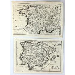
(2 Maps) Aloud Spanje & Gallia Narbonensis Lugdunensis et Aquitania
Two unusual maps of Ancient Europe by H. Besseling in Utrecht ca. 1757. One is of Ancient Spain (Aloud Spanje), and the other is of Ancient France, (Gallia Narbonensis et...
Date: Utrecht, 1757
Selling price: ????
Please login to see price!
Sold in 2018
Imperium Caroli Magni Occidentis Imperatoris...
An attractive and detailed map of Charlemagne's empire, from England to the Mediterranean Sea. Includes the Low Countries, Germany, France, Spain, Switzerland, Austria, I...
Date: Paris, 1757
Selling price: ????
Please login to see price!
Sold in 2016
Souverainetés de l'Europe.
Map of the various sovereignty of Europe.Left and right a box with geographical information about the various Empires of Europe .Prepared by Buy de Mornas, who was a prof...
Date: Paris 1762
Selling price: ????
Please login to see price!
Sold
Carta Nuova dell Europa.
Fine colored copper engraved map of Europe based on Delisle's map. Two block style cartouches, by Albrizi after I. Tirion. Giambattista Albrizzi (1698-1777) was a Veneti...
Date: Venice from 1740-1762
Selling price: ????
Please login to see price!
Sold in 2016
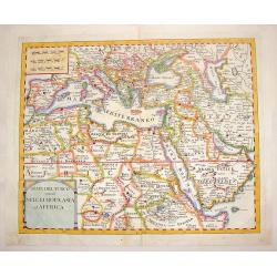
Stati del Turco Situati Nell Europa, Asia ed Affrica.
Fine copperplate map of Europe with Northern Africa and Western Asia. Includes two block-style cartouches.Giambattista Albrizzi (1698-1777) was a Venetian publisher and j...
Date: Venice, 1740-1762
Selling price: ????
Please login to see price!
Sold in 2016
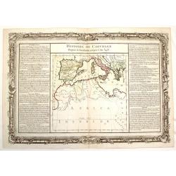
Histoire de Carthage - Depuis sa Foundation Jusqu'a L'An 3481.
Fine copper engraved map of a portion of ancient Carthage, around the Mediterranean Sea. It is decorated with a floral frame that interestingly, was printed separately fr...
Date: Paris, 1762
Selling price: ????
Please login to see price!
Sold in 2015
![[A Lot of 2 maps Europe]](/uploads/cache/IMG_0092-250x250.jpg)
[A Lot of 2 maps Europe]
Claude Buy de Mornas (d. 1783), géographe du roi (1764). Atlas Méthodique et Elémentaire de Géographie et d' Histoire, 1761, Atlas Historique et Géographique, 1762. ...
Date: Paris, 1762
Selling price: ????
Please login to see price!
Sold in 2025
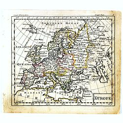
Europe.
Uncommon miniature map of Europe, engraved by Thomas Kitchin for "A New General and Universal Atlas Containing Forty-five Maps by Andrew Dury." This miniature a...
Date: London, 1761-1763
Selling price: ????
Please login to see price!
Sold in 2019
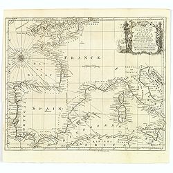
A New and Correct Chart of the Seat of War on the Coasts of France, Spain, Portugal and Italy. . .
A map showing the southern coast of England, all of France, Spain and Portugal, the very tip of the north African coastline, and the Mediterranean Sea as far east as Sici...
Date: London, 1763
Selling price: ????
Please login to see price!
Sold in 2020
![[2 maps] Orbis Romani pars Occidentalis / Pars Orientalis...](/uploads/cache/38420-250x250.jpg)
[2 maps] Orbis Romani pars Occidentalis / Pars Orientalis...
A pair of large folding maps by d'Anville, that joined together make up the Roman Empire (combined map size approx. 1370 x 1110 mm). Western sheet comprised of western E...
Date: Paris, 1764
Selling price: ????
Please login to see price!
Sold in 2018
Carte de l'Empire de Charle-Magne...
A highly detailed engraved 1764 map of the Empire of Charlemagne. It covers Europe and the European Empire of Charles the Great from Ireland south as far as northern Afri...
Date: Venice, 1765
Selling price: ????
Please login to see price!
Sold in 2017
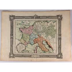
Carte générale d'Allemagne divisée et numérotée...des postes et autres routes de cet empire.
Map of Germany and neighboring countries.A so called post road mapspost route map.Desnos, born in a small village close to Beauvais, was apprenticed to Joseph-Simon Guibo...
Date: Paris, 1766
Selling price: ????
Please login to see price!
Sold in 2011
l' Europe.
Louis Brion de la Tour (1756-1823), ' Atlas Géneral, Civil et Ecclésiastique', 1766, ' Atlas Général', 1790-98. Louis Charles Desnos (fl.1750-70), Le Rouge's 'Atlas N...
Date: Paris, 1769
Selling price: ????
Please login to see price!
Sold
Nieuwe Kaart van Europa
Nice map of Europe extending to include Iceland. Political divisions are delineated in original color and major cities are located.
Date: Amsterdam 1769
Selling price: ????
Please login to see price!
Sold
L'Europe Dressée..
Map of Europe, with an explanatory text on left/right sides. The map and the text are surrounded by a decorative frame, wrapped in garlands, on which stand out the instru...
Date: Paris, 1768-1769
Selling price: ????
Please login to see price!
Sold
Nieuwe Kaart van Europa
Nice map of Europe extending to include Iceland. Political divisions are delineated in original color and major cities are located.
Date: Amsterdam, 1769
Selling price: ????
Please login to see price!
Sold
L'Europe Dressée. . .
Map of Europe, with an explanatory text on left and right sides.
Date: Paris, 1768-1769
Selling price: ????
Please login to see price!
Sold in 2016
Europa Drawn and Engraved from the best maps and charts.
Fine map of the continent of Europe.
Date: London 1771
Selling price: ????
Please login to see price!
Sold
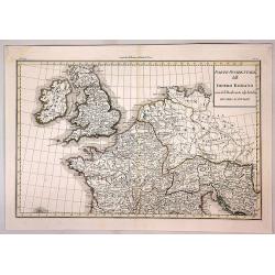
GERMANY, FRANCE ITALY, SPAIN, BRITISH ISLES, In an intermediate Century between Antient and Modern Geography.
Jean Baptist d' Après de Mannevilette (1707-1780), French hydrographer. His sea-atlas of the Asian waters, the ' Neptune Oriental 'was published in 1755.A map of western...
Date: London, R. Sayer and J. Bennett, 1771
Selling price: ????
Please login to see price!
Sold
Germanie, France, Italie, Espagne, Isles Britanniques,; Dans un Age intermediaire de l'Anciene Geographie et de la Moderne
A beautiful 18th century map of Europe by Jean Baptiste Bourguignon D'Anville, showing the areas of ancient civilizations of Europe. Areas of ancient civilization shown i...
Date: Paris, 1771
Selling price: ????
Please login to see price!
Sold in 2010
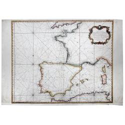
Carte Reduite Des Costes de France, De Portugal, et D'Espagne sur l'Ocean et sur la Mediterranee. 1771.
A detailed chart of the coastline of south western Europe. Coastal detail only, interiors left blank. Decorative cartouche. Rhumb lines , published by the French Hydrogra...
Date: Paris, 1771
Selling price: ????
Please login to see price!
Sold in 2020
A New and Accurate Map of Europe. Divided into its Empires, Kingdoms, States and Republics. . .
An exceptional example of the top two sheets of this wall map size 4-sheet map of Europe. Includes extensive text and tables on either side of the map. This map of the ...
Date: London, 1772
Selling price: ????
Please login to see price!
Sold in 2016
L'Europe Divisee Dans Ses Principaux Etats
A large, striking example of the 1774 edition of the Guillaume Danet, a very decorative map of Europe, surrounded as it is by 110 coats of arms, showing the various state...
Date: Paris, 1774
Selling price: ????
Please login to see price!
Sold in 2016
L'Europa divisa Ne Suoi Principali Stati.
Original outline color, with decorative colored title cartouche to upper left corner. Double page map of Europe. Blank on verso.
Date: Venice, 1775
Selling price: ????
Please login to see price!
Sold in 2020
A New & Accurate Map of Europe, Drawn from the best Authorities.
Detailed map of Europe engraved by Thomas Bowen for "BANKES'S NEW SYSTEM OF GEOGRAPHY" in LONDON IN 1777. Iceland is oversized.
Date: London, 1777
Selling price: ????
Please login to see price!
Sold in 2017
A New & Accurate Map of Europe, Drawn from the Best Authorities.
A fine engraved map including all of Europe, Iceland, the Mediterranean, and the Barbary Coast, by Thomas Bowen in England in 1777. From “A New & Accurate Map of E...
Date: London, 1777
Selling price: ????
Please login to see price!
Sold in 2018
Theatrum Historicum.. Romani tu Barbarorum.. Pars Occidentalis..
Showing the Roman Empire by G. de l'Isle, French cartographer, pupil of Cassini, called Father of Modern Geography. In upper left hand corner the Western hemisphere. Engr...
Date: Paris, 1780
Selling price: ????
Please login to see price!
Sold in 2008
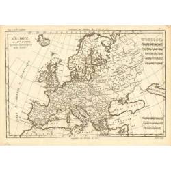
L' Europe
Rigobert Bonne (1727-1795), French cartographer. His maps are found in a.o. Atlas Moderne (1762), Raynal's Histoire Philos. du Commerce des Indes (1774) and Atlas Encyclo...
Date: Paris, c. 1780
Selling price: ????
Please login to see price!
Sold
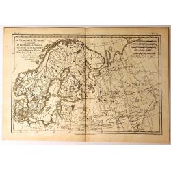
Le Nord de L'Europe
A fine map of Northern Europe and European Russia. It covers the modern day countries of Norway, Sweden, Finland, Denmark, and Finland as well as parts of Russia (includi...
Date: Paris, 1780
Selling price: ????
Please login to see price!
Sold in 2015
Parte Occidentale dell Impero Romano ....
The western part of the Ancient Roman Empire by Anville. It covers the areas of England (Bretagna), Ireland (Hybernia), France (Gallia) and Germania.Jean Baptiste Bourgu...
Date: Paris, ca. 1780
Selling price: ????
Please login to see price!
Sold in 2017
Europa secondo le ultime osservazioni dell' Academia reala delle Scienze.
Rare map of Europe, from "Atlante Novissimo ad uso Dei Giovani Studiosi Contenuto In Carte XXVII.", published by Giovanni Zempel in Rome, ca. 1780.The map is ba...
Date: Rome, 1780
Selling price: ????
Please login to see price!
Sold in 2022
Europa veteribus nota. L'Europe Ancienne.
Rarely seen map of ancient Europe. Filled with old names and details. Text panel to the left. With a decorative title cartouche. Engraved by Moithey and Herault.
Date: Paris, ca. 1780
Selling price: ????
Please login to see price!
Sold in 2019
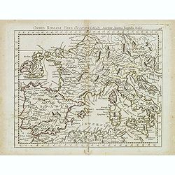
Orbis Romani Pars Ocidentalis. . .
Map of the ancient Roman Empire, prepared by Nolin and published by L.J. Mondhare for his Atlas Général a l'usage des colleges et maisons d'education.. Louis Joseph Mon...
Date: Paris, 1781
Selling price: ????
Please login to see price!
Sold in 2023
L'Europe divisée en ses principaux Etats.
A beautiful example of Jean Janvier's decorative map of the Europe. Covers from Iceland to the Caspian Sea and from North Africa to the Arctic. Divided into countries and...
Date: Paris, 1782
Selling price: ????
Please login to see price!
Sold in 2012
Neue Carte von Europa welche die merkwürdigsten Producte und vornehmsten Handelsplätze...
Rare thematic map showing Europe's economy. It illustrates 56 products and resources, including gold, copper, wine, fruit, salt, hemp, silk, horses, and so on. Nine furth...
Date: Dessau, 1782
Selling price: ????
Please login to see price!
Sold in 2016
