Browse Listings in Europe > British Isles > General
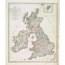
Karta öfver Stora Britannien eller England, Scotland och Irland.
An very rare map of Great Britain with Swedish text. This is an updated version of his map of 1819 and is now dated 1832.From his atlas "Geographisk Hand-Atlas"...
Date: A. Wiborgs förlag, Stockholm, ca. 1848
Selling price: ????
Please login to see price!
Sold in 2013
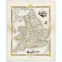
England and Wales.
A delightful small map of England and Wales, by Alfred Adlard, published in his Vignette Modern School Atlas of the World. When looking at this map you are immediately st...
Date: London, 1850
Selling price: ????
Please login to see price!
Sold in 2020
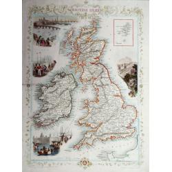
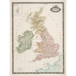
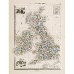
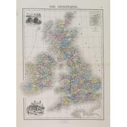
The British Isles.
A highly decorative and detailed mid-19th century map of the British Isles, which was drawn and engraved by J. Rapkin with the vignettes by John Salmon & Robert Walli...
Date: London, 1851
Selling price: ????
Please login to see price!
Sold in 2016
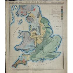
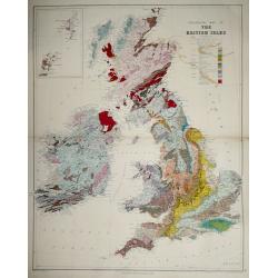
Geological map England & Wales.
An unusual geological map of England and Wales with a key to the colors used. The map is hand drawn and hand colored apart from the title and border, it bears the inscrip...
Date: London, ca. 1858
Selling price: ????
Please login to see price!
Sold in 2018
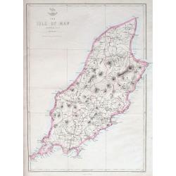
The Isle of Man.
A highly detailed map of the island, filled with place names, roads, hills, etc.The Weekly Dispatch newspaper was published in London between the years 1856 and 1862, an...
Date: London, ca 1860
Selling price: ????
Please login to see price!
Sold in 2018
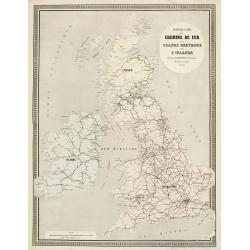
Isles Britanniques carte des chemins de fer et canaux.
Very detailed map from Atlas Sphéroïdal & Universel de géographie , Prepared by F.A.Garnier and edited by Jules Renouard, rue de Tournon, Paris. Uncommon map with ...
Date: Paris, 1861
Selling price: ????
Please login to see price!
Sold in 2011
Isles Britanniques, Angleterre, Ecosse, Irlande. . .
Very detailed map from Atlas Sphéroïdal & Universel de géographie, Prepared by F.A.Garnier and edited by Jules Renouard, rue de Tournon, Paris. Uncommon map with d...
Date: Paris, 1861
Selling price: ????
Please login to see price!
Sold in 2011
Nouvelle Carte des Chemins de Fer de la Grande Bretagne et de l'Irlande. . .
Fine map of England, Scotland and Ireland showing the early railway system of the area.From Atlas des Chemins de Fer published by Napoléon Chaix and printed by Imprimeri...
Date: Paris, 1863
Selling price: ????
Please login to see price!
Sold in 2011
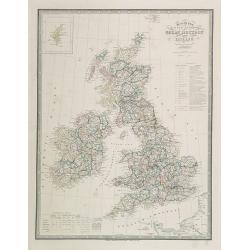
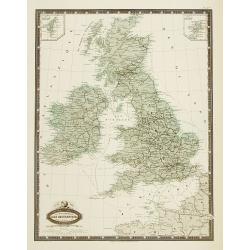
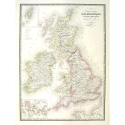
Map of the United Kingdom of Great Brittain and Ireland.
Very detailed map of Great Britain and Ireland. Lower left statistic table and upper left inset map of Shetland Islands.James Wyld (the younger) was geographer to the Que...
Date: London, 1863
Selling price: ????
Please login to see price!
Sold in 2009
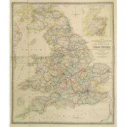
A Map of England, Wales & Scotland..
Very detailed map of England, Wales and Scotland. In upper right hand corner inset map of northern part of Scotland.James Wyld (the younger) was geographer to the Queen a...
Date: London, 1863
Selling price: ????
Please login to see price!
Sold in 2023
![[4-sheets] Wales.](/uploads/cache/39117-250x250.jpg)
[4-sheets] Wales.
Large four-sheet map of Wales by Edward Weller, published in the 'Dispatch Atlas'.Map consists of a N.E. sheet, from Montgomeryshire up to the River Dee, a S.E. sheet fro...
Date: London, 1863
Selling price: ????
Please login to see price!
Sold in 2017
![[4-sheets] England and Wales.](/uploads/cache/39119-250x250.jpg)
[4-sheets] England and Wales.
Large four-sheet map of England and Wales by Edward Weller, published in the 'Dispatch Atlas'.Map consists of a S.E. sheet, showing London and the 'Home Counties', a S.W....
Date: London, 1863
Selling price: ????
Please login to see price!
Sold in 2017
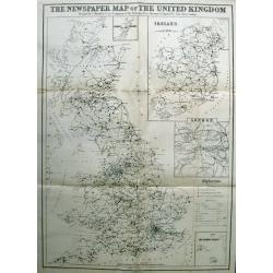
The Newspaper Map of the United Kingdom.
Large map, showing the distribution and variety of newspaper publication in the UK. A key has symbols that give an explanation of towns with one paper, more than one pape...
Date: London, 1872
Selling price: ????
Please login to see price!
Sold in 2015
Iles Britanniques.
Decorative map of the British Isles from GĂ©ographie Universelle, Atlas Migeon. published by J. Migeon. In lower left hand corner a view of the tower of London and an eng...
Date: Paris 1874
Selling price: ????
Please login to see price!
Sold
Iles Britanniques.
A decorative map of England, Wales, Scotland, and Ireland from GĂ©ographie Universelle, Atlas Migeon. An engraving of the XVIth century London Tower in the lower-left cor...
Date: Paris, 1874
Selling price: ????
Please login to see price!
Sold in 2015
Carte physique et politique des iles britanniques.
Very large, highly detailed and uncommon map of the British Isles, with inset map of the world and the Shetland Islands. The map shows according to the title: main interr...
Date: Paris, 1875
Selling price: ????
Please login to see price!
Sold in 2010
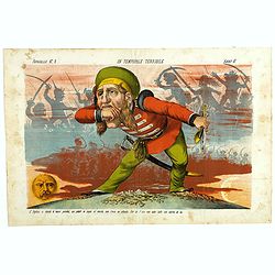
Un Temporale terribile. Papagallo No. 2. Anno VI.
Showing an English figure standing on British and American soil. Design by Augusto Grossi. Taken from the Italian satirical newspaper Il Papagallo, a satirical magazine f...
Date: Bologne, 1878
Selling price: ????
Please login to see price!
Sold in 2019
Geological map of the British Isles.
Geological map of the British Isles by Edward Best, published by Edward Stanford. Steel engraved.Shows 27 geologic units. Includes inset of the Shetland and Orkney islan...
Date: London, 1887
Selling price: ????
Please login to see price!
Sold in 2014
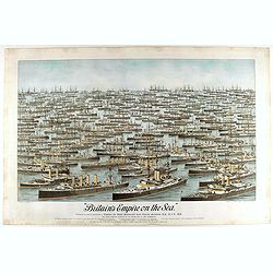
Britain's Empire on the Sea. Dedicated to Captain the Right Honourable Lord Charles Beresford...
A very decorative and large chromolithographed plate showing all the effective strength of the British navy with the name and class of each ship shown beneath, except for...
Date: Portsea, ca. 1897
Selling price: ????
Please login to see price!
Sold in 2025
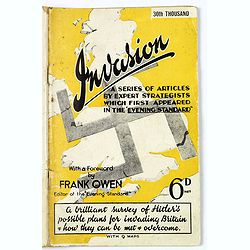
Invasion. A Series of Articles by Expert Strategists with 9 maps.
An interesting small quarto sized 64 page booklet covering Invasion, a series of articles by expert strategists which first appeared in The Evening Standard.A brilliant s...
Date: London / Melbourne, ca. 1941
Selling price: ????
Please login to see price!
Sold in 2017
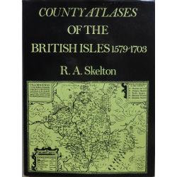
County Atlases Of The British Isles 1579-1703.
A most informative reference book. Cloth bound with dust jacket 250 pages plus illustrations and figures. The definitive carto-bibliography. Published in 1970 by Carta Pr...
Date: London, 1970
Selling price: ????
Please login to see price!
Sold in 2017
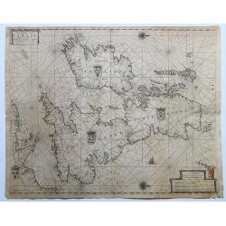
Pas-Caart vant Canaal Vertoonende in 't Gheheel Engelandt, Schotlandt, Yrlandt, en een Gedeelte van Vrancryck.
A fine chart of the British Isles. North is oriented to the right. Embellished with two compass roses, a galleon under sail and four national coats of arms. This chart ap...
Date: Amsterdam, 1665-1666.
Selling price: ????
Please login to see price!
Sold in 2020
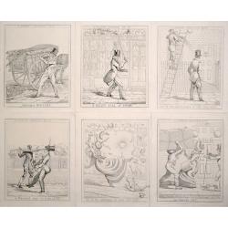
(Complete set of 6) A London Nuisance.
Scarce and amusing series of 6 plates depicting the dangers of the London streets.Complete set of 6 "A London Nuisance", etchings by Richard Dighton, plates 1-6...
Date: London, 1821
Selling price: ????
Please login to see price!
Sold in 2026
