Browse Listings in Europe
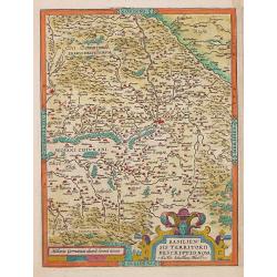
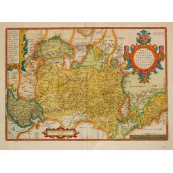
BASILIEN: / SIS TERRITORII / DESCRIPTIO NOVA.
Abraham Ortelius(1527-98), Dutch cartographer and publisher of the first modern atlas, ' Theatrum Orbis Terrarum' in 1570. Editions till 1612. Also an atlas of ancient ca...
Date: Antwerp, Robert Bruneau, 1609
Selling price: ????
Please login to see price!
Sold in 2020
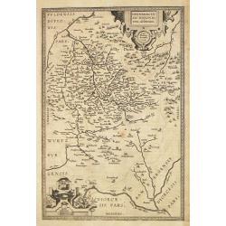
HENNENBERGEN: / SIS DITIONIS. / vera delineatio.
Abraham Ortelius(1527-98), Dutch cartographer and publisher of the first modern atlas, ' Theatrum Orbis Terrarum' in 1570. Editions till 1612. Also an atlas of ancient ca...
Date: Antwerp, Robert Bruneau, 1609
Selling price: ????
Please login to see price!
Sold in 2013
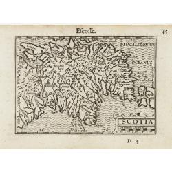
Scotia.
A miniature map of Scotland. Fine cartouche.First published in 1598 in his Caert-Thresoor, the plates were executed by the most famous engravers in Amsterdam, including P...
Date: Amsterdam/Frankfurt 1609
Selling price: ????
Please login to see price!
Sold
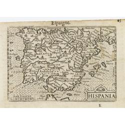
Hispania.
A miniature map of Spain. Fine cartouche in the lower right corner.First published in 1598 in his Caert-Thresoor, the plates were executed by the most famous engravers in...
Date: Amsterdam/Frankfurt 1609
Selling price: ????
Please login to see price!
Sold
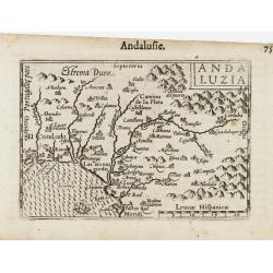
Andaluzia.
A miniature map of Andalusia. Fine cartouche in the lower right corner.First published in 1598 in his Caert-Thresoor, the plates were executed by the most famous engraver...
Date: Amsterdam/Frankfurt 1609
Selling price: ????
Please login to see price!
Sold
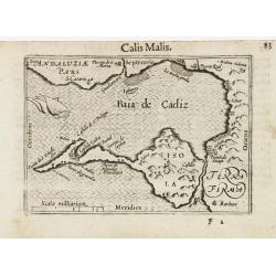
Calis Malis.
A miniature map of Cadiz.First published in 1598 in his Caert-Thresoor, the plates were executed by the most famous engravers in Amsterdam, including Petrus Kaerius and J...
Date: Amsterdam/Frankfurt 1609
Selling price: ????
Please login to see price!
Sold
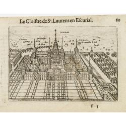
Le Cloitre de St Laurent en Escurial.
A miniature view of San Lorenzo del Escorial Monastery, residence of Philip II.First published in 1598 in his Caert-Thresoor, the plates were executed by the most famous ...
Date: Amsterdam/Frankfurt 1609
Selling price: ????
Please login to see price!
Sold

Portugallia.
A miniature map of Portugal.First published in 1598 in his Caert-Thresoor, the plates were executed by the most famous engravers in Amsterdam, including Petrus Kaerius an...
Date: Amsterdam/Frankfurt 1609
Selling price: ????
Please login to see price!
Sold
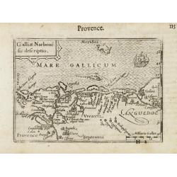
Galliae Narbone sis descriptio.
A miniature map of the Languedoc, including towns of Marseille, Avignon, Narbonne, etc. South to the top. Fine cartouche in the upper left corner. The sea is decorated wi...
Date: Amsterdam/Frankfurt 1609
Selling price: ????
Please login to see price!
Sold
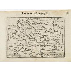
Burgundiae Com.
A miniature map of the Burgundy. Title cartouche in the lower right corner.First published in 1598 in his Caert-Thresoor, the plates were executed by the most famous engr...
Date: Amsterdam/Frankfurt, 1609
Selling price: ????
Please login to see price!
Sold
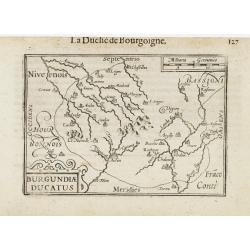
Burgundiae Ducatus.
A miniature map of the Burgundy. Title cartouche in the lower left corner.First published in 1598 in his Caert-Thresoor, the plates were executed by the most famous engra...
Date: Amsterdam/Frankfurt 1609
Selling price: ????
Please login to see price!
Sold
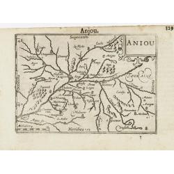
Aniou / Anjou.
A miniature map of the Loire valley, centered on Angers. Title cartouche in the upper right corner.First published in 1598 in his Caert-Thresoor, the plates were executed...
Date: Amsterdam/Frankfurt, 1609
Selling price: ????
Please login to see price!
Sold in 2015
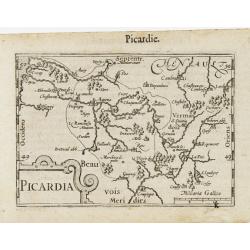
Picardia / Picardie.
A miniature map of northern part of France, centered on Amiens. Title cartouche in the lower left corner.First published in 1598 in his Caert-Thresoor, the plates were ex...
Date: Amsterdam/Frankfurt 1609
Selling price: ????
Please login to see price!
Sold
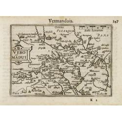
Veromandui / Vermandois.
A miniature map of northern part of France. Title cartouche on the left side.First published in 1598 in his Caert-Thresoor, the plates were executed by the most famous en...
Date: Amsterdam/Frankfurt 1609
Selling price: ????
Please login to see price!
Sold in 2014
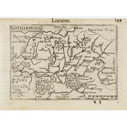
Lotharingia / Lorraine.
A miniature map of eastern part of France. Title cartouche on the upper left corner.First published in 1598 in his Caert-Thresoor, the plates were executed by the most fa...
Date: Amsterdam/Frankfurt 1609
Selling price: ????
Please login to see price!
Sold
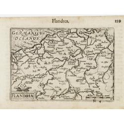
Flandria.
A miniature map including both part of France and Belgium. Title cartouche on the lower left corner.First published in 1598 in his Caert-Thresoor, the plates were execute...
Date: Amsterdam/Frankfurt 1609
Selling price: ????
Please login to see price!
Sold
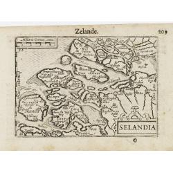
Selandia / Zelande.
A miniature map of Zeeland. Title cartouche on the lower right corner.First published in 1598 in his Caert-Thresoor, the plates were executed by the most famous engravers...
Date: Amsterdam/Frankfurt 1609
Selling price: ????
Please login to see price!
Sold
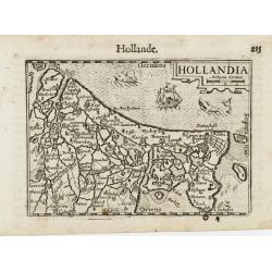
Holandia / Hollande.
A miniature map of Holland. Title cartouche on the upper right corner. The sea is decorated with two fantastic animals and a ship.First published in 1598 in his Caert-Thr...
Date: Amsterdam/Frankfurt 1609
Selling price: ????
Please login to see price!
Sold
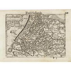
Zyudhollad / Zud Hollande.
A miniature map of Holland. Title cartouche on the upper left corner. The sea is decorated with a ship.First published in 1598 in his Caert-Thresoor, the plates were exec...
Date: Amsterdam / Frankfurt, 1609
Selling price: ????
Please login to see price!
Sold
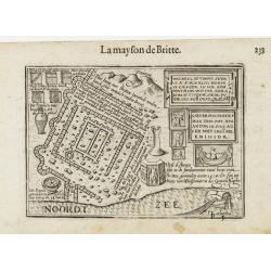
La Mayson de Britte.
A miniature view of a castle, including the plan and a description of few objects. The legend is in Dutch, and is translated overleaf in French. The sea is decorated with...
Date: Amsterdam/Frankfurt 1609
Selling price: ????
Please login to see price!
Sold

Trans Isula D. / Over Ysel.
A miniature map covering the province of Overijssel. Title cartouche on the lower right corner.First published in 1598 in his Caert-Thresoor, the plates were executed by ...
Date: Amsterdam/Frankfurt 1609
Selling price: ????
Please login to see price!
Sold
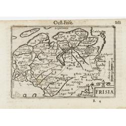
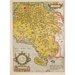
Frisia.
A miniature map covering the province of Friesland in Germany. Title cartouche on the lower right corner.First published in 1598 in his Caert-Thresoor, the plates were ex...
Date: Amsterdam/Frankfurt 1609
Selling price: ????
Please login to see price!
Sold
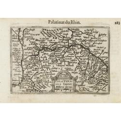
Palatinatus Rheni / Palatinat du Rhin.
A miniature map centered on Heidelberg and Manheim. Title cartouche on the lower part.First published in 1598 in his Caert-Thresoor, the plates were executed by the most ...
Date: Amsterdam/Frankfurt 1609
Selling price: ????
Please login to see price!
Sold
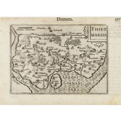
Thiet Marsia.
A miniature map of Holstein. Title cartouche on the upper right corner.First published in 1598 in his Caert-Thresoor, the plates were executed by the most famous engraver...
Date: Amsterdam/Frankfurt 1609
Selling price: ????
Please login to see price!
Sold
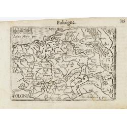
Poloigne.
A miniature map of Poland. Title cartouche on the lower left corner.First published in 1598 in his Caert-Thresoor, the plates were executed by the most famous engravers i...
Date: Amsterdam/Frankfurt 1609
Selling price: ????
Please login to see price!
Sold
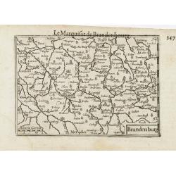
Brandenburg / Marquisat de Brandebourg.
A miniature map of Brandenburg province. The title cartouche on the lower right corner.First published in 1598 in his Caert-Thresoor, the plates were executed by the most...
Date: Amsterdam / Frankfurt, 1609
Selling price: ????
Please login to see price!
Sold in 2022
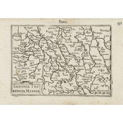
Saxonia / Thuringia / Misnia.
A miniature map centered on Saxen, Misnie and Thuringen. Title cartouche on the lower left corner.First published in 1598 in his Caert-Thresoor, the plates were executed ...
Date: Amsterdam / Frankfurt, 1609
Selling price: ????
Please login to see price!
Sold in 2021
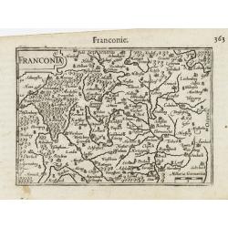
Franconia.
A miniature map including Frankfort and Nuremberg, Title cartouche on the upper left corner.First published in 1598 in his Caert-Thresoor, the plates were executed by the...
Date: Amsterdam/Frankfurt ,1609
Selling price: ????
Please login to see price!
Sold in 2021
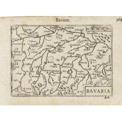
Bavaria.
A miniature map showing a part of Bavaria, including the cities of Innsbruck, Augsburg, Ingolstat, Munich, etc. Title cartouche on the lower right corner.First published ...
Date: Amsterdam/Frankfurt 1609
Selling price: ????
Please login to see price!
Sold
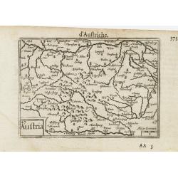
Austria.
A very decorative miniature map of Austria. Title cartouche on the lower left corner.First published in 1598 in his Caert-Thresoor, the plates were executed by the most f...
Date: Amsterdam/Frankfurt 1609
Selling price: ????
Please login to see price!
Sold
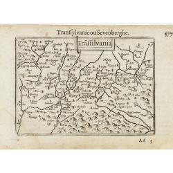
Trassilvania / Transilvanie / Sevenberghe.
A miniature map of Transylvania. Title cartouche centered on upper side.First published in 1598 in his Caert-Thresoor, the plates were executed by the most famous engrave...
Date: Amsterdam/Frankfurt, 1609
Selling price: ????
Please login to see price!
Sold in 2009
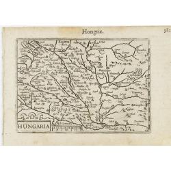
Hungaria.
A miniature map of Hungary, centered on Budapest. Title cartouche on the lower left corner.First published in 1598 in his Caert-Thresoor, the plates were executed by the ...
Date: Amsterdam/Frankfurt 1609
Selling price: ????
Please login to see price!
Sold
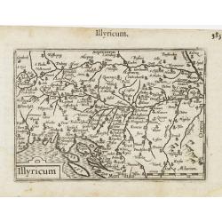
Illyricum.
A miniature map of Istria and Slovenia. Title cartouche on the lower left corner.First published in 1598 in his Caert-Thresoor, the plates were executed by the most famou...
Date: Amsterdam / Frankfurt, 1609
Selling price: ????
Please login to see price!
Sold in 2023
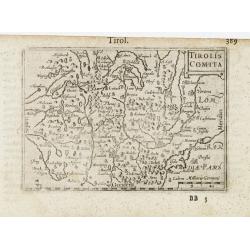
Tirolis Comita.
A miniature map of the Tirol. Title cartouche on the upper right corner.First published in 1598 in his Caert-Thresoor, the plates were executed by the most famous engrave...
Date: Amsterdam/Frankfurt 1609
Selling price: ????
Please login to see price!
Sold
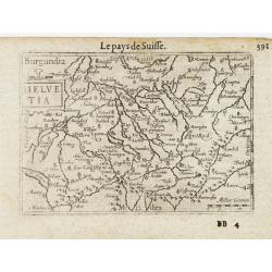
Helvetia.
A miniature map of the Switzerland, centered on Zurich. Title cartouche on the upper left side.First published in 1598 in his Caert-Thresoor, the plates were executed by ...
Date: Amsterdam/Frankfurt, 1609
Selling price: ????
Please login to see price!
Sold in 2008
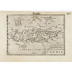
Candia / Candie.
A miniature map of Crete. Title cartouche on the lower right corner. Surrounding the island, two sea monsters and a ship are depicted.First published in 1598 in his Caert...
Date: Amsterdam/ Frankfurt, 1609
Selling price: ????
Please login to see price!
Sold in 2012
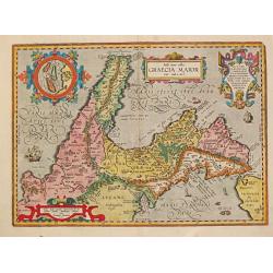
Itala nam tellus / GRAECIA MAIOR. - Diomedeae Insulae.
Abraham Ortelius(1527-98), Dutch cartographer and publisher of the first modern atlas, ' Theatrum Orbis Terrarum' in 1570. Editions till 1612. Also an atlas of ancient ca...
Date: Antwerp, Robert Bruneau, 1609
Selling price: ????
Please login to see price!
Sold
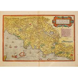
Thusciae Descriptio Auctore Hienomymo Bellarmato.
Abraham Ortelius(1527-98), Dutch cartographer and publisher of the first modern atlas, ' Theatrum Orbis Terrarum' in 1570. Editions till 1612. Also an atlas of ancient ca...
Date: Antwerp, 1609
Selling price: ????
Please login to see price!
Sold in 2017
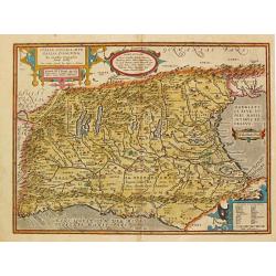
ITALIA GALLICA, SIVE / GALLIA CISALPINA.
Abraham Ortelius(1527-98), Dutch cartographer and publisher of the first modern atlas, "Theatrum Orbis Terrarum" in 1570. Editions till 1612. Also an atlas of a...
Date: Antwerp, Robert Bruneau, 1609
Selling price: ????
Please login to see price!
Sold in 2016
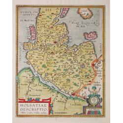
HOLSATIAE / DESCRIPTIO.
Abraham Ortelius(1527-98), Dutch cartographer and publisher of the first modern atlas, 'Theatrum Orbis Terrarum' in 1570. Editions till 1612. Also an atlas of ancient car...
Date: Antwerp, Robert Bruneau, 1609
Selling price: ????
Please login to see price!
Sold
Senensis ditionis, accurata descriptio.
Abraham Ortelius(1527-98), Dutch cartographer and publisher of the first modern atlas, ' Theatrum Orbis Terrarum' in 1570. Editions till 1612. Also an atlas of ancient ca...
Date: Antwerp, Robert Bruneau, 1609
Selling price: ????
Please login to see price!
Sold in 2013
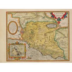
Latium.
The second state of the map of the area south of Rome in classical times with an inset of Mount Circaeus, the supposed dwelling of mythical goddess witch Circe, who encha...
Date: Antwerp, Robert Bruneau, 1609
Selling price: ????
Please login to see price!
Sold
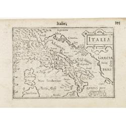
Italia.
A miniature map of Italy. Title cartouche on the upper right corner.First published in 1598 in his Caert-Thresoor, the plates were executed by the most famous engravers i...
Date: Amsterdam/Frankfurt 1609
Selling price: ????
Please login to see price!
Sold in 2009
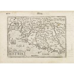
Histria.
A miniature map of Istria, including the Gulf of Venice. Title cartouche on the lower left corner. On the south side of the island two ships and a sea monster are depicte...
Date: Amsterdam/Frankfurt 1609
Selling price: ????
Please login to see price!
Sold
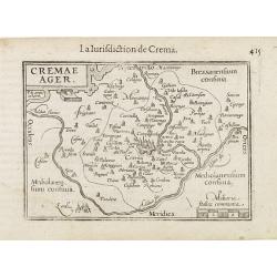
Cremae Ager.
A miniature map of Lombardy, centered on the city of Crema. Title cartouche on the upper left corner.First published in 1598 in his Caert-Thresoor, the plates were execut...
Date: Amsterdam/Frankfurt 1609
Selling price: ????
Please login to see price!
Sold
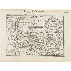
Cremonensis Ager.
A miniature map of Italy, centered on the city of Cremona. Title cartouche on the upper right side.First published in 1598 in his Caert-Thresoor, the plates were executed...
Date: Amsterdam/Frankfurt 1609
Selling price: ????
Please login to see price!
Sold
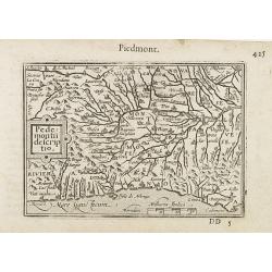
Pedemontii Descriptio / Piemont.
A miniature map of Piedmont. Title cartouche on the left side.First published in 1598 in his Caert-Thresoor, the plates were executed by the most famous engravers in Amst...
Date: Amsterdam/Frankfurt 1609
Selling price: ????
Please login to see price!
Sold
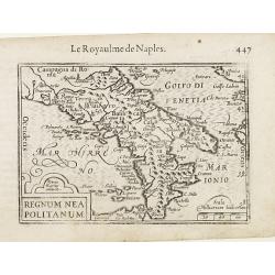
Regnum Neapotlitanum.
A miniature map of southern Italy, centered on the city of Naples. Title cartouche on the lower left corner. First published in 1598 in his Caert-Thresoor, the plates wer...
Date: Amsterdam/Frankfurt 1609
Selling price: ????
Please login to see price!
Sold
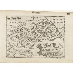
Aprutium / Abruzzo.
A miniature map of northern Italy, centered on the mountains. Title cartouche on the lower right corner. First published in 1598 in his Caert-Thresoor, the plates were ex...
Date: Amsterdam/Frankfurt 1609
Selling price: ????
Please login to see price!
Sold
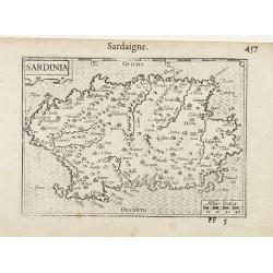
Sardinia.
A miniature map centered on the island of Sardinia. Title cartouche on the upper left corner. First published in 1598 in his Caert-Thresoor, the plates were executed by t...
Date: Amsterdam/Frankfurt 1609
Selling price: ????
Please login to see price!
Sold
![Scio. [Chios]](/uploads/cache/23064-250x250.jpg)
Scio. [Chios]
A miniature map of Scio, the Italian name for the Greek Island of Chios.First published in 1598 in his Caert-Thresoor, the plates were executed by the most famous engrave...
Date: Amsterdam/Frankfurt 1609
Selling price: ????
Please login to see price!
Sold
WEST: / PHALIAE / TOTIUS, FINI: / TIMARUMQUE . REGIONUM / ACCURATA / DESCRIP: / TIO. 1579.
Abraham Ortelius(1527-98), Dutch cartographer and publisher of the first modern atlas, ' Theatrum Orbis Terrarum' in 1570. Editions till 1612. Also an atlas of ancient ca...
Date: Antwerp, Robert Bruneau, 1609
Selling price: ????
Please login to see price!
Sold
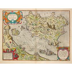
Ischia quae olim Aenaria.
Abraham Ortelius(1527-98), Dutch cartographer and publisher of the first modern atlas, ' Theatrum Orbis Terrarum' in 1570. Editions till 1612. Also an atlas of ancient ca...
Date: Antwerp, Robert Bruneau, 1609
Selling price: ????
Please login to see price!
Sold
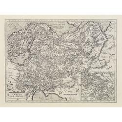
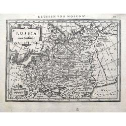
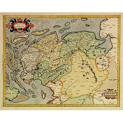
Russia cum confinijs.
An extremely decorative and historic map, showing Scandinavia, Russia, and the regions directly south of the Crimea.With inset map of the central region round Moscow, enl...
Date: Amsterdam 1595 - 1609
Selling price: ????
Please login to see price!
Sold
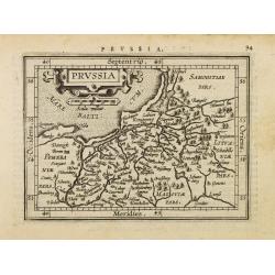
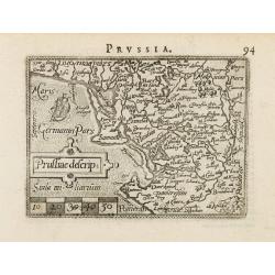
Prussia.
Miniature map of the coast of Poland, with major cities named. Strapwork title cartouche at the top. Latin text on verso.
Date: Antwerp, 1609
Selling price: ????
Please login to see price!
Sold in 2008
Prussiae descrip:
Miniature map of the coast of Poland, with major cities named. North is orientated to the left of the page. Latin text on verso.
Date: Antwerp, 1609
Selling price: ????
Please login to see price!
Sold in 2008
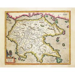
Morea olim Peloponnesus. per Gerardum Mercatorum.
Gerard Mercator's ' Atlas sive Cosmographica' was augmented and published in 1606 by Jodocus Hondius.Gerard Mercator's map of the Peloponesus, published by Jodocus Hondiu...
Date: Amsterdam, 1609
Selling price: ????
Please login to see price!
Sold in 2018
Saxonie Inferior et Meklenborg Duc.
Mercators Saxony map with gold highlights. French text on verso.
Date: Amsterdam, 1609
Selling price: ????
Please login to see price!
Sold in 2009
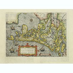
Hollandiae Cattorum regionis typus.
Guicciardini's reduced version of Jacob van Deventer's survey of the province of Holland surveyed in 1537 and published first in Antwerp in nine sheets by Bernard van der...
Date: Antwerp, 1609
Selling price: ????
Please login to see price!
Sold in 2011
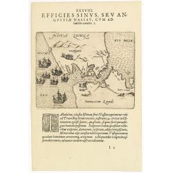
XXXVIII. Effigies Sinus, Sev Angustiae Nassau, cum adiunctis caeteris. 3.
Fine map shows Waijgats with Nassau Strait separating Nova Zembla from Russia, in the North Sea to the left is a fleet of seven Dutch ships.Theodore de Bry, a German engr...
Date: Frankfurt, 1609
Selling price: ????
Please login to see price!
Sold in 2018
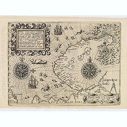
Theodore De Bry: Tabula terrae Novae Zemblae in qua fretum sinusq Waigats item ord littorialis Tartariae atq Russiae, ad urgem usq Kildeinam . . . Authore Gerhardo De Veer.
Fine map Nova Zembla and the coast of Russia, Lapland and the Sea filled with sea monsters, ships and two remarkable compass roses. Drawn by Gerard de Veer, a survivor of...
Date: Frankfurt, 1609
Selling price: ????
Please login to see price!
Sold in 2013
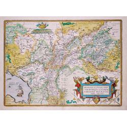
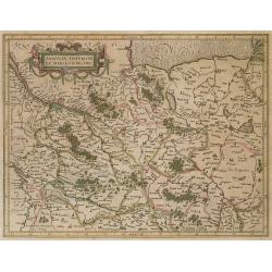
Gelriae, Cliviae, Finitimorumque Locorum Verrisima Descriptio Christiano Schrot Auctore.
Map of Gelderland en Overijsel. Based upon a map by Christian Sgrooten, now extinct. Decorated with a strapwork title-cartouche and a cartouche with scales.Abraham Orteli...
Date: Antwerp,1609
Selling price: ????
Please login to see price!
Sold in 2018
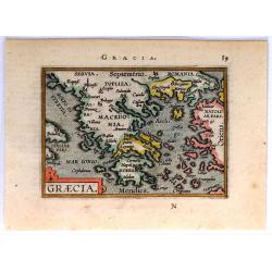
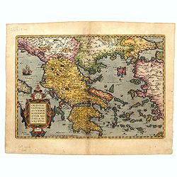
Graecia
Charming miniature map of Greece and Macedonia from a Latin edition of Ortelius’s pocket atlas “Epitome Theatri Orbis Terrarum”.Copied from Phillip Galle, and engra...
Date: Antwerp, 1609
Selling price: ????
Please login to see price!
Sold in 2017
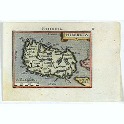
Hibernia.
Miniature map of Ireland with major cities named. North is oriented to the right of the map. Sea is stipple engraved. Strap work title cartouche at upper right. Latin tex...
Date: Antwerp, 1609
Selling price: ????
Please login to see price!
Sold in 2017
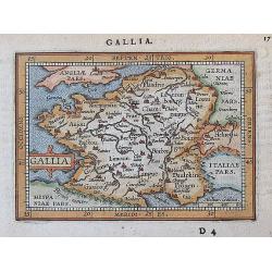
Gallia.
A charming miniature map of France with major cities shown. Extends to show London, Cologne, Bern, and Coblenz. Latin text on verso.
Date: Antwerp, 1609
Selling price: ????
Please login to see price!
Sold in 2017
Russia cum Confiniis.
An early map of western Russia from the "Atlas Minor" (Gerhard Mercator / Jodocus Hondius). Extends from Lappland until the Caspian Sea. With two small cartouch...
Date: Amsterdam, (or later) 1609
Selling price: ????
Please login to see price!
Sold in 2018
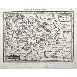
Moscovia.
An early map of the area around Moscow from the "Atlas Minor" (Gerhard Mercator / Jodocus Hondius). Extends from Narwa (Estonia) until Moscow. Including the cit...
Date: Amsterdam, ca. 1609
Selling price: ????
Please login to see price!
Sold in 2018
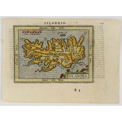
ISLANDIA.
A very beautiful miniature map of Iceland based on Ortelius’ important map of the Island. Major cities named, the sea is stipple engraved, with a nice strap work title ...
Date: Antwerp, 1609
Selling price: ????
Please login to see price!
Sold in 2019
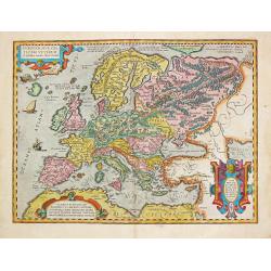
Europam, sive Celticam Veterem.
An attractive map of Europe, according to the Romans. Embellished with three strap work cartouches. From the extremely rare Spanish edition of Abraham Ortelius’ ‘Thea...
Date: Antwerp, 1609
Selling price: ????
Please login to see price!
Sold in 2021
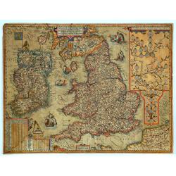
Angliae et Hiberniae Accurata Decriptio. . .
One of the most decorative and rare maps of Great Britain and Ireland by Jan Baptist Vrients (1552-1612) in original color. The map first appeared in 1606, and this is st...
Date: Antwerp, 1609
Selling price: ????
Please login to see price!
Sold in 2020
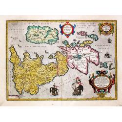
Brittanicarum Insularum Typus. 1595.
A map of Roman Britain based on information from Mercator's 1564 map of the British Isles, improved by a new outline from Saxton's 1579 map, and ancient knowledge from Di...
Date: Antwerp, 1609
Selling price: ????
Please login to see price!
Sold in 2021
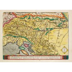
Schlavoniae, Croatiae, Carniae, Istriae, Bosniae, Finitimarumque Regionum Nova Descriptio.
Abraham Ortelius’ map is based on the map of the Turkish border by Augustin Hirschvogel of 1539. Third state. From the rare Spanish edition of Abraham Ortelius’ ‘Th...
Date: Antwerp, 1609
Selling price: ????
Please login to see price!
Sold in 2021
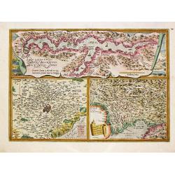
Larii acus vulgo Comensis.
Three maps on one sheet, the upper one depicts Lake Como, the lower two show Rome and its direct vincinity, respectively Friuli. The Como map is based on the map by Paolo...
Date: Antwerp, 1609
Selling price: ????
Please login to see price!
Sold in 2021
![[Lot of 4 maps of the Duchy of Urbino]](/uploads/cache/18487-250x250.jpg)
[Lot of 4 maps of the Duchy of Urbino]
Ortelius rare map of the Duchy of Urbino based upon the map by Giovanni Antonio Magini of 1596. One of the maps in the 'Theatrum', that appeared only in the 'Theatrum' ...
Date: Antwerp, 1609
Selling price: ????
Please login to see price!
Sold in 2022
![[Lot of 7 maps of the Balkan] ILLYRICUM.](/uploads/cache/IMG_9507-250x250.jpeg)
[Lot of 7 maps of the Balkan] ILLYRICUM.
Abraham Ortelius(1527-98), Dutch cartographer and publisher of the first modern atlas, ' Theatrum Orbis Terrarum' in 1570. Editions till 1612. Also an atlas of ancient ca...
Date: Antwerp, 1609
Selling price: ????
Please login to see price!
Sold in 2022
Graeciae Universae Secundum Hodiernum Situm Neoterica..
Ortelius' fine map of Greece, based on Jacobo Gastaldi's map of 1560. Provenance: This map is from the personal collection of dr. Marcel van den Broecke, author of ...
Date: Antwerp, 1609
Selling price: ????
Please login to see price!
Sold in 2023
Frisia occidentalis.
Finely engraved map of the provinces Groningen and Friesland. Prepared by Gerard Mercator and published by Jodocus Hondius.
Date: Amsterdam 1610
Selling price: ????
Please login to see price!
Sold
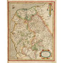
Boloniae & Guines comitatus.
Very fine copper engraving, showing the coastline from Brique till Grevelinge including Calais.Decorated with two finely engraved cartouches.
Date: Amsterdam 1610
Selling price: ????
Please login to see price!
Sold
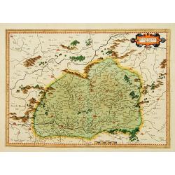
Burgundia Ducatus.
One of the earliest maps of Burgundy.
Date: Amsterdam 1610
Selling price: ????
Please login to see price!
Sold
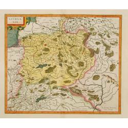
Lithuania.
One of the earliest maps of Lithuania and Poland.
Date: Amsterdam 1610
Selling price: ????
Please login to see price!
Sold
