Browse Listings in Europe
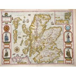
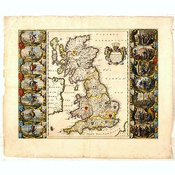
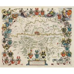
The Kingdome of Scotland.
Attractive rare "carte à figures"- map of Scotland embellished with the portraits of A Scotch man, A Highland Man, A Scotch Woman, and a Highland Woman.English...
Date: London, 1662
Selling price: ????
Please login to see price!
Sold in 2012
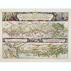
Tractus Borysthenis vulgo Dniepr et Niepr Dicti, à Bovzin . . .
This superb map shows the lower part of the Dniepr River, extending to the Black Sea in two horizontal strips, the upper map with a compass rose orienting the map, west t...
Date: Amsterdam, 1662
Selling price: ????
Please login to see price!
Sold in 2012

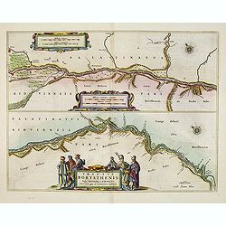
Tractus Borysthenis vulgo Dniepr et Niepr Dicti, à Kiovia ufque ad Bouzin.
This superb map shows the upper part of the Dnieper River in two horizontal strips, the upper map with a compass rose orienting the map, west to the top. It is richly emb...
Date: Amsterdam, 1662
Selling price: ????
Please login to see price!
Sold in 2012
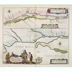
Tractus Borysthenis vulgo Dniepr et Niepr Dicti, à Bovzin . . .
This superb map shows the upper part of the Dnieper River in two horizontal strips, the upper map with a compass rose orienting the map, west to the top. It is richly emb...
Date: Amsterdam, 1662
Selling price: ????
Please login to see price!
Sold in 2012
Tractus Borysthenis vulgo Dniepr et Niepr Dicti, à Chortika Ostro ad Urbem Oczakow . . .
This superb map shows the upper part of the Dnieper River in two horizontal strips, the upper map with a compass rose orienting the map, west to the top. It is richly emb...
Date: Amsterdam, 1662
Selling price: ????
Please login to see price!
Sold in 2012
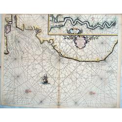
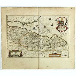
Pascaerte van Engelant vant Voorland tot aen Blakeney, waer in te sien is de mont vande Teemse. . .
Rare chart showing the West coast of England and the mouth of the River Thames. The upper right inset shows the Thames from London into the North Sea. With decorative flo...
Date: Amsterdam, 1662
Selling price: ????
Please login to see price!
Sold in 2018
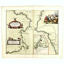
Nova & accurata Wolgae fluminis, olim Rha dicti, delineatio / auctore Adamo Oleario.
Joan Blaeu's copper plate showing a map of the Volga River in three parts based on the travels of Adam Olearius. The left side of the map begins at Nazhniy Novgorod and e...
Date: Amsterdam, 1662
Selling price: ????
Please login to see price!
Sold in 2014
Britannia prout divisa suit temporibus Anglo-Saxonum, præsertim durante illorum Heptarchia.
Blaeu's decorative map shows the British Isles at the time of the Anglo-Saxon Heptarchy; the seven ancient kingdoms of Kent, the South Saxons, West Saxons, East Saxons, N...
Date: Amsterdam, 1645-1662
Selling price: ????
Please login to see price!
Sold in 2015
![Nobilibus Amplissimis Q. Dominis D. Georgio De La Faille Toparchae Deneuele &c. Praetori Totiq. Colllegio Supremae Curiae Feudalis Regiae Veteris Burgi Gandensis [Gent]](/uploads/cache/38732-250x250.jpg)
Nobilibus Amplissimis Q. Dominis D. Georgio De La Faille Toparchae Deneuele &c. Praetori Totiq. Colllegio Supremae Curiae Feudalis Regiae Veteris Burgi Gandensis [Gent]
Fine map centered on Gent in Flandres with inset "Graven Kasteel". From Blaeu's Atlas Major.
Date: Amsterdam, 1662
Selling price: ????
Please login to see price!
Sold in 2019
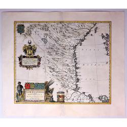
Norlandiae et Quibies Gestricia et Helsingicae Regiones.
A striking, rare map with a cartouche dedicated to Gabriel Bengtsson Oxenstierna. The 'Atlas Maior' is the epitome of decades of achievement by the famous Blaeu family. P...
Date: Amsterdam, 1662
Selling price: ????
Please login to see price!
Sold in 2017
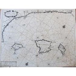
De Custen van Valencia en Catalonia van C. de S. Martyn tot C. Dragonis, als meede de Eylanden van Majorca, Minorca en Yvica.
Important early Dutch sea chart by Goos from his important Atlas Zee-spiegel. Includes the northeastern coast of Spain with Valencia, Tarragona, and Barcelona. With the B...
Date: Amsterdam, ca. 1662
Selling price: ????
Please login to see price!
Sold in 2017
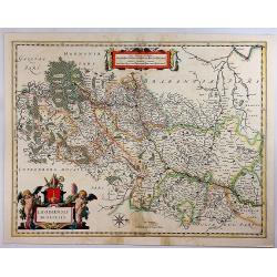
Leodiensis Dioecesis.
A map of Liege, a province in Belgium. A splendidly decorative map of the Muese River and valley, including Namur and Liege, with west oriented at top of map. Franchimo...
Date: Amsterdam, 1662
Selling price: ????
Please login to see price!
Sold in 2018
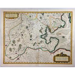
Oldenburg Comitatus.
An attractive map of the region of Oldenburg and Bremen, showing the Jadebusen, and the estuary of the Weser. The topography and towns are beautifully detailed with nice ...
Date: Amsterdam, 1662
Selling price: ????
Please login to see price!
Sold in 2018
Nordlandiae et Quibies Gestricia et Helsingicae Regiones.
A fine antique map of Sweden or Norrland, with two originally colored cartouches, a figured title cartouche and a heraldic cartouche, with a total of six coats-of-arms in...
Date: Amsterdam, 1662
Selling price: ????
Please login to see price!
Sold in 2018
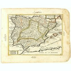
Espagne. (24).
Scarce map of Spain and Portugal published by Antoine de Fer in 1661 or 1662 in "Cartes de géographie revues et augmentées". With number 24 in lower right bot...
Date: Paris, Antoine de Fer, 1657 but 1661 or 1662
Selling price: ????
Please login to see price!
Sold in 2018
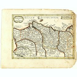
Portugal et Algarve. (25).
Scarce map of Portugal and Algarve published by Antoine de Fer in 1661 or 1662 in "Cartes de géographie revues et augmentées". With number 25 in lower right b...
Date: Paris, Antoine de Fer, 1657 but 1661 or 1662
Selling price: ????
Please login to see price!
Sold in 2021
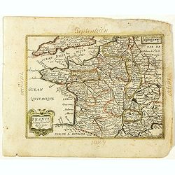
France Nouvellement descripte 1651. (26).
Scarce map of Africa in its second state published by Antoine de Fer in 1661 or 1662 in "Cartes de géographie revues et augmentées".With number 26 in lower ri...
Date: Paris, Antoine de Fer, 1657 but 1661 or 1662
Selling price: ????
Please login to see price!
Sold in 2019
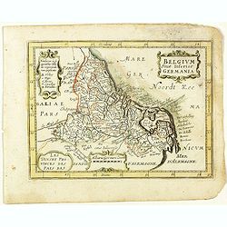
Belgium sive Inferior Germania. (27).
Scarce map of the Netherlands and Belgium published by Antoine de Fer in 1661 or 1662 in "Cartes de géographie revues et augmentées".With number 27 in lower r...
Date: Paris, Antoine de Fer, 1657 but 1661 or 1662
Selling price: ????
Please login to see price!
Sold in 2020
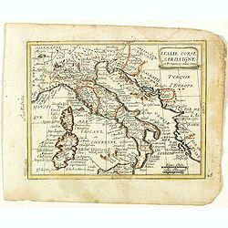
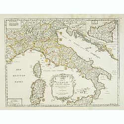
Italie Corse Sardaigne et Provinces adiacentes. (28).
Scarce map of Italy, Corsica and Sardinia published by Antoine de Fer in 1661 or 1662 in "Cartes de géographie revues et augmentées". With number 28 in lower ...
Date: Paris, Antoine de Fer, 1657 but 1661 or 1662
Selling price: ????
Please login to see price!
Sold in 2023
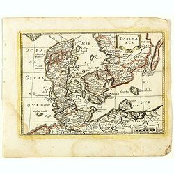
Danmarck. (30).
Scarce map of Denmark published by Antoine de Fer in 1661 or 1662 in "Cartes de géographie revues et augmentées". With number 30 in lower right bottom of the ...
Date: Paris, Antoine de Fer, 1657 but 1661 or 1662
Selling price: ????
Please login to see price!
Sold in 2018
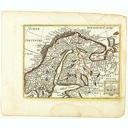
Norvege et Suede. (31).
Scarce map of Norway, Finland and Sweden published by Antoine de Fer in 1661 or 1662 in "Cartes de géographie revues et augmentées". With number 31 in lower r...
Date: Paris, Antoine de Fer, 1657 but 1661 or 1662
Selling price: ????
Please login to see price!
Sold in 2018
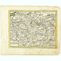
Polongne. (32).
Scarce map of Poland published by Antoine de Fer in 1661 or 1662 in "Cartes de géographie revues et augmentées". With number 32 in lower right bottom of the m...
Date: Paris, Antoine de Fer, 1657 but 1661 or 1662
Selling price: ????
Please login to see price!
Sold in 2018
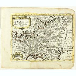
Grande Russie ou Blanche Avec ses confins 1651. (33).
Scarce map of Russia published by Antoine de Fer in 1661 or 1662 in "Cartes de géographie revues et augmentées". With number 33 in lower right bottom of the m...
Date: Paris, Antoine de Fer, 1657 but 1661 or 1662
Selling price: ????
Please login to see price!
Sold in 2018
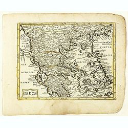
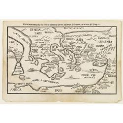
Grece. (36).
Scarce map of Greece published by Antoine de Fer in 1661 or 1662 in "Cartes de géographie revues et augmentées". The series of maps is largely derived from th...
Date: Paris, Antoine de Fer, 1657 but 1661 or 1662
Selling price: ????
Please login to see price!
Sold in 2019
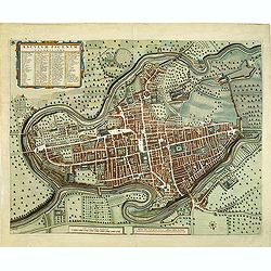
Lothian and Linlitquo.
This is a very detailed and striking map of the areas of Lothian and Linlithgow in Scotland. It is rare from Joan Blaeu's Atlas Major, with three added ships.The map cent...
Date: Amsterdam, 1662
Selling price: ????
Please login to see price!
Sold in 2018
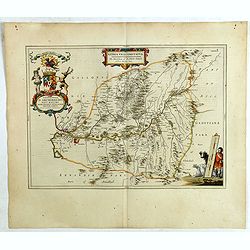
Nithia Vicecomitatus, The Shirifdome of Nidis-dail / auctore Timotheo Pont.
This is a detailed and striking map of the areas of Nidis-dail in Scotland. It is rare from Joan Blaeu's Atlas Major.Prepared by Timothy Pont and Robert Gordon. The map i...
Date: Amsterdam, 1662
Selling price: ????
Please login to see price!
Sold in 2019
![Carricta meridionalis, [vulgo], The South part of Carrick / auct. Timoth. Pont.](/uploads/cache/42489-250x250.jpg)
Carricta meridionalis, [vulgo], The South part of Carrick / auct. Timoth. Pont.
This detailed and striking map of the southern part of Carrick in Scotland is rare from Joan Blaeu's Atlas Major.Prepared by Timothy Pont and Robert Gordon. The map is en...
Date: Amsterdam, 1662
Selling price: ????
Please login to see price!
Sold in 2020
Cuninghamia / ex schedis Timotheo Pont , Ioannis Blaeu excudebat. Cunningham.
A very detailed map and a striking map of Cunningham in Scotland. Rare from Joan Blaeu's Atlas Major.Prepared by Timothy Pont and Robert Gordon. The map is enhanced by se...
Date: Amsterdam, 1662
Selling price: ????
Please login to see price!
Sold in 2019
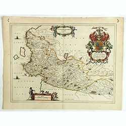
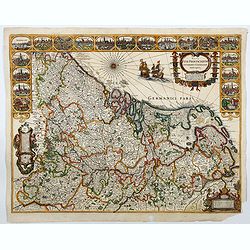
Wigorniensis Comitatus et Comitatus Warwicensis, nec non Coventrae libertas.
A beautifully, detailed 1662 French Edition of the Blaeu copper engraved map of Worcestershire and Warwickshire. The map provides excellent topographic details on cities,...
Date: Amsterdam, 1662
Selling price: ????
Please login to see price!
Sold in 2019
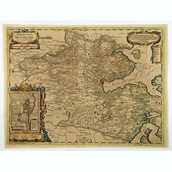
Praefectura Apenrade et Luntoft herde.
This highly decorative and map of southern Denmark centres on the town of Aabenraa. This historical map is from the famous Atlas Maior published in Amsterdam in 1662. The...
Date: Amsterdam, 1662
Selling price: ????
Please login to see price!
Sold in 2021
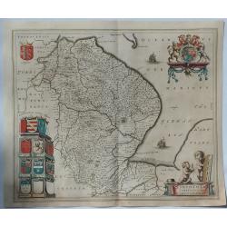
Lincolnia Comitatus. Anglia Lincoln-Shire.
A fine old color example of Blaeu's map of Lincoln, from his “Atlas Maior”, one of the most sought-after atlases by collectors and institutions today due to the atten...
Date: Amsterdam, 1662
Selling price: ????
Please login to see price!
Sold in 2019
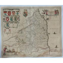
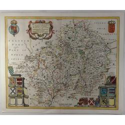
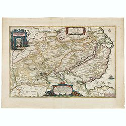
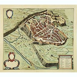
Comitatus Northumbria Vernacule Northumberland.
A fine very decorative old color map of Northumberland from the 1662 publication of Blaeu's “Atlas Major", one of the most sought-after atlases by collectors and i...
Date: Amsterdam, 1662
Selling price: ????
Please login to see price!
Sold in 2019
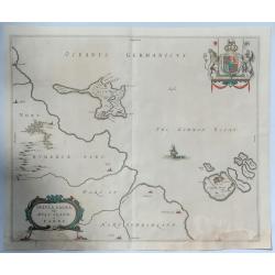
Insula Sacra vulgo Hosy Iland et Farne.
Map of Holy Island and Farne off the coast of Northumberland, in north east England, from the 1662 publication of Blaeu's “Atlas Major" one of the most sought-afte...
Date: Amsterdam, 1662
Selling price: ????
Please login to see price!
Sold in 2019
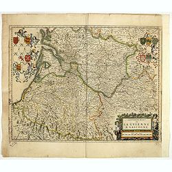
Gouvernement de la Guienne & Gascogne.
Decorative map of Guyenne et Gascogne with cartouches on each side with regional coats of arms and an allegorical title cartouche with wine grapes and puttie.
Date: Amsterdam, ca. 1662
Selling price: ????
Please login to see price!
Sold in 2019
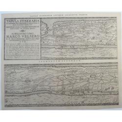
Tabula Itineraria Ex Illustri Peutingerorum. (the two Western-European segments only, Segmentum Primum, and Segmentum Secundum.)
A rare and famous map from the Peutinger Table comprising Western-Europe. Twee parts of eight only. The ancient roadmap depicts the imperial roads and posts within the Ro...
Date: Amsterdam, ca. 1662
Selling price: ????
Please login to see price!
Sold in 2020
Nordertheil des Amptes Gottorff, Anno 1649.
Map after J. Mejer from Danckwerth, shows the area around Hollingstedt, Holm, Schleswig, Eckernförde, Kappeln, Schlei, Husby. Appeared first in 1652 in "New descrip...
Date: Amsterdam, 1662
Selling price: ????
Please login to see price!
Sold in 2022
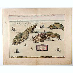
Insulae Tremitanae, olim Diomedeae dictae.
In his Atlas Maior of 1662, Joan Blaeu (1598-1673) published 58 maps of Italian regions. Most of these maps were unedited reprints of maps that Blaeu had originally publi...
Date: Amsterdam, 1662
Selling price: ????
Please login to see price!
Sold in 2020
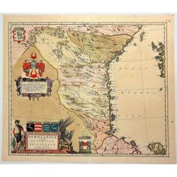
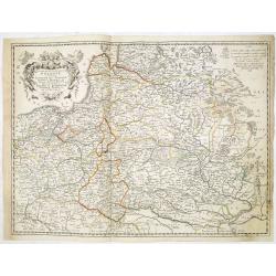
Nova XVII Provinciarum Inferioris Germaniae Descriptio.
An early and rare map by de Wit of the 17 provinces. The map was originally engraved by P. Kaerius in 1607, and later came into the possession of de Wit, who re-engraved ...
Date: Amsterdam 1662
Selling price: ????
Please login to see price!
Sold in 2022
![[Battle of Szigetvár] Portraict de l'Armée de l'Empereur Turc Rangée en Bataille](/uploads/cache/49040-250x250.jpg)
[Battle of Szigetvár] Portraict de l'Armée de l'Empereur Turc Rangée en Bataille
An early wood block printed bird's-eye view showing the Battle of Szigetvár (Hungary). Below the wood block print is a 8-lines description in French. The battle was one ...
Date: Paris, 1662
Selling price: ????
Please login to see price!
Sold in 2025
Deze Caerte van de reysen Pauli..
Rare wood block map, depicting the Mediterranean, with an over-sized Cyprus from the final Dutch edition of Heinrich Bünting's famous Itinerarium Sacrae Scripturae, a bo...
Date: Amsterdam 1663
Selling price: ????
Please login to see price!
Sold
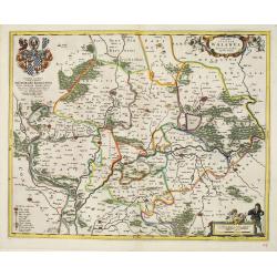
Novam Hanc TERRITORII FRANCOFURTENSIS Tabulam..
Map of Hessen, centred on Frankfurt and the river Main, bordered by design with arms and titles of 33 dignitaries, allegorical figures and cartouche shields with German E...
Date: Amsterdam 1663
Selling price: ????
Please login to see price!
Sold
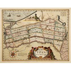
Agri Zypani Nova Descript.
Fine map of the region of the Zype. From a French text edition.The copperplate was originally by Petrus Kaerius, but was considerably revised by Joan Blaeu for his Atlas ...
Date: Amsterdam, 1663
Selling price: ????
Please login to see price!
Sold in 2019
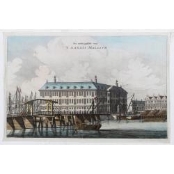
Een ander gesicht van 'T LANDTS MAGAZYN.
A decorative print of the 'T Landts Magazyn, formerly the V.O.C. warehouse and arsenal for the Admiralty of Amsterdam, now-a-days the Scheepvaartmuseum (Maritime Museum)....
Date: Amsterdam, 1663
Selling price: ????
Please login to see price!
Sold in 2023
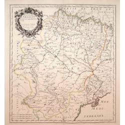
Royaume d'Arragon divisé, en sept dioeceses..
Map of Aragon, with original or early outline hand-color. Numerous place-names of counties, cities, towns, physical features. Prepared by N.Sanson.
Date: Paris, 1663
Selling price: ????
Please login to see price!
Sold in 2009
Etats de la couronne de Pologne ou sont les Royaume de Pologne, . . . De l'Ukanie &c.
A map of Poland, Dantzick (Gdansk) clearly marked on the coast and stretching down to the Black Sea. Numerous place-names of counties, cities, towns, physical features.
Date: Paris, 1663
Selling price: ????
Please login to see price!
Sold in 2009
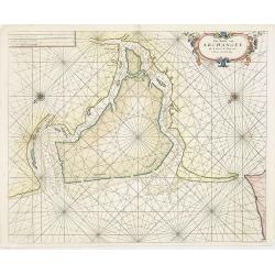
Pas-Caert van Archangel oste de rivier de Duina met.'t Nieuwe en't Oude diep.
Rare sea chart of th mouth of the Dwina River and the port town of Archangel, published by Jacob Theunisz (Lootsman). At first Jacob adopted his father Anthonie's name, b...
Date: Amsterdam, 1663
Selling price: ????
Please login to see price!
Sold in 2009
Tabula Russiae ex autographo, quod delineandum curavit Foedor filius Tzaris Boris desumta
Third state of a map by Hessel Gerritsz with an inset plan of Moscow and a view of Archangel. Without text on the back
Date: Amsterdam, c.1663
Selling price: ????
Please login to see price!
Sold in 2010
Le Gouvernement General Du Daufiné et des Pays circomuoisins ou sont La Savoye, La Bresse.
Map of central eastern France including Savoy and Bresse from Merian's atlas, "Topographia Galliae". Numerous cities and regions are noted including Lyon, Genev...
Date: Amsterdam, 1663
Selling price: ????
Please login to see price!
Sold in 2010
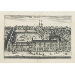
La Cour du Prince ou College de l'Admirauté. - HET PRINCEN HOF.
Decorative view of the "Prinsen Hof" in Amsterdam, now-a-days the "Hotel The Grand".Published in a French edition of "Historische Beschrijving de...
Date: Amsterdam, c.1663
Selling price: ????
Please login to see price!
Sold in 2020

Endhauptung deß Königs in Engelandt Ano 1649.
A fine copperplate engraving, unnamed from Theatrum Europaeum, Volume 6, printed by Daniel Fievet, Frankfurt 1663.King Charles I King of England, Scotland and Ireland who...
Date: Frankfurt,1663
Selling price: ????
Please login to see price!
Sold in 2011
Carte de L'Italie et des Isles adjacentes. . .
Detailed map of Italy, Sardine and Malta. With inset map of Sicily. Title at bottom with erasure in the title. Map is dated 1663 and was engraved by L'Huilier.
Date: Paris, 1663
Selling price: ????
Please login to see price!
Sold
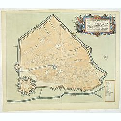
Ichnografia del Recinto del la citta di Ferrara. . .
A beautifully engraved and richly decorated plan of Ferrera. With a key (1-18) in lower right corner referring to the principal places of interest in the town. From "...
Date: Amsterdam, 1663
Selling price: ????
Please login to see price!
Sold in 2013
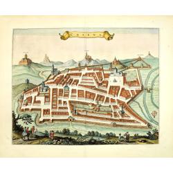
Cesena.
A beautifully engraved and richly decorated town-plan of Cesena, a city in the Emilia-Romagna region of northern Italy, south of Ravenna and west of Rimini. From "Ci...
Date: Amsterdam, 1663
Selling price: ????
Please login to see price!
Sold in 2012
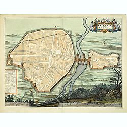
Faventia, vulgo Faensa.
A beautifully engraved and richly decorated plan of Faenza, an important historic city situated on the Via Emilia between Rimini and Bologna.From "Civitates Ecclesia...
Date: Amsterdam, 1663
Selling price: ????
Please login to see price!
Sold in 2012
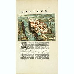
Castrum.
A beautifully engraved and richly decorated town-plan of a town and castle along a river. . With a key (1-18) in lower right corner referring to the principal places of i...
Date: Amsterdam, 1663
Selling price: ????
Please login to see price!
Sold in 2012
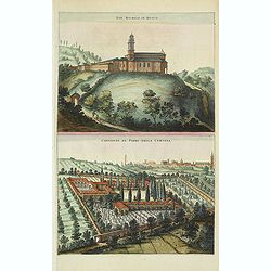
San. Michele in Bosco. / Convento de' Padri della Certosa.
A beautifully engraved and richly decorated town-plan of San Michele in Bosco and in bottom Ordine Certosino. From "Civitates Ecclesiastici - Theatrum Civitatum et a...
Date: Amsterdam, 1663
Selling price: ????
Please login to see price!
Sold in 2012
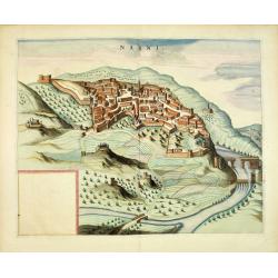
Narni.
A beautifully engraved and richly decorated of Narni, an ancient hilltown and comune of Umbria, in central Italy. From "Civitates Ecclesiastici - Theatrum Civitatum...
Date: Amsterdam, 1663
Selling price: ????
Please login to see price!
Sold in 2013
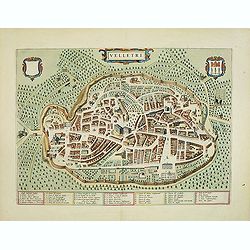
Velletri.
A beautifully engraved and richly decorated town-plan of Velletri, a comune in the province of Rome, on the Alban Hills, in Lazio (Latium). With a key (1-40) in bottom. F...
Date: Amsterdam, 1663
Selling price: ????
Please login to see price!
Sold in 2012
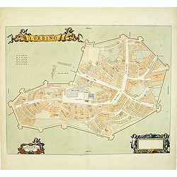
Urbino.
A schematic town-plan of Urbino. From "Civitates Ecclesiastici - Theatrum Civitatum et admirandorum Italiae".Joan Blaeu originally wanted to put two five-volume...
Date: Amsterdam, 1663
Selling price: ????
Please login to see price!
Sold in 2012
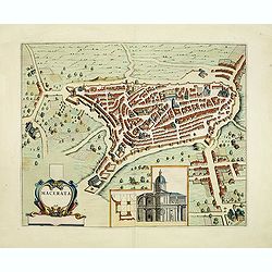
Macerata.
A beautifully engraved and richly decorated town-plan of Macerata, the provincial capital of Macerata in Le Marche region. The medieval part is located on a hill overlook...
Date: Amsterdam, 1663
Selling price: ????
Please login to see price!
Sold in 2012
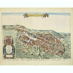
Auximum vulgo Osimo.
A beautifully engraved and richly decorated town-plan of Osimo. A key (1-31) at the bottom refers to the principal places of interest in the town. From "Civitates Ec...
Date: Amsterdam, 1663
Selling price: ????
Please login to see price!
Sold in 2012
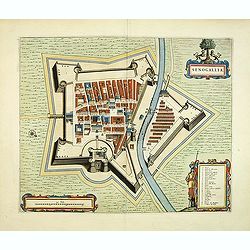
Senogallia.
A beautifully engraved and richly decorated town-plan of Senigallia. With a key (A-Z) in lower right corner referring to the principal places of interest in the town. Fro...
Date: Amsterdam, 1663
Selling price: ????
Please login to see price!
Sold in 2013
Avenio Vulgo Avignon.
A beautifully engraved and richly decorated town-plan of Avignon. With a key (1-56) around the plan referring to the principal places of interest in the town. From "...
Date: Amsterdam, 1663
Selling price: ????
Please login to see price!
Sold in 2012
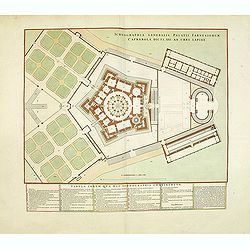
Ichnographia Generalis Palatii Farnesiorum Caprarola Dicti, XXI Ab Urbe Lapide. . .
A beautifully engraved and richly decorated plan of the garden and Villa Farnese, also known as Villa Caprarola, is a mansion in the town of Caprarola in the province of ...
Date: Amsterdam, 1663
Selling price: ????
Please login to see price!
Sold in 2012
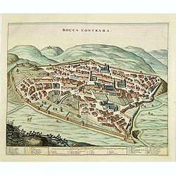
Rocca Contrada.
A beautifully engraved and richly decorated town-plan of Arcevia (Marche), formerly known as Rocca Contrada. With a key (1-33) in bottom referring to the principal places...
Date: Amsterdam, 1663
Selling price: ????
Please login to see price!
Sold in 2013
Civitas-Nova in Piceno. / Mezzogiorno.
A beautifully engraved and richly decorated town-plan of Civitanova Marche. With a key (1-24) in lower right corner referring to the principal places of interest in the t...
Date: Amsterdam, 1663
Selling price: ????
Please login to see price!
Sold in 2012
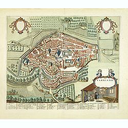
Fabriano.
A beautifully engraved and richly decorated town-plan of Fabriano, with in the center Piazza Maggiore with S.Francisco and the papal palace to the left. With a key (1-84)...
Date: Amsterdam, 1663
Selling price: ????
Please login to see price!
Sold in 2012
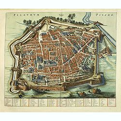
Pisaurum Vulgo Pesaro.
A beautifully engraved and richly decorated town-plan of Pesaro. With a key (1-100 / a- z) in bottom referring to the principal places of interest in the town. From "...
Date: Amsterdam, 1663
Selling price: ????
Please login to see price!
Sold in 2012
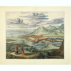
Pisaurum vulgo Pezaro.
A beautifully engraved and richly decorated town-plan of the seaside city of Pesaro and the surrounding countryside, as well as a dramatic depiction of the Adriatic coast...
Date: Amsterdam, 1663
Selling price: ????
Please login to see price!
Sold in 2012
Asculum Picenum.
A beautifully engraved and richly decorated town-plan of Ascoli Piceno. A key (1-18) in the lower right corner refers to the principal places of interest in the town. Fro...
Date: Amsterdam, 1663
Selling price: ????
Please login to see price!
Sold in 2012
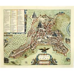
Tuder vulgo Todi.
A beautifully engraved and richly decorated town-plan of Todi. With a key (1-86) in upper left corner referring to the principal places of interest in the town. From &quo...
Date: Amsterdam, 1663
Selling price: ????
Please login to see price!
Sold in 2012
Gubbio Cita Regia Antichiss, Dell'umbria.
A beautifully engraved and richly decorated town-plan of Gubio. With a key (1-45) in lower right corner referring to the principal places of interest in the town. From &q...
Date: Amsterdam, 1663
Selling price: ????
Please login to see price!
Sold in 2012
Acquapendente.
A beautifully engraved and richly decorated town-plan of Acquapendente in the province of Viterbo, Lazio. A key (1-27) in the lower right corner refers to the principal p...
Date: Amsterdam, 1663
Selling price: ????
Please login to see price!
Sold in 2012
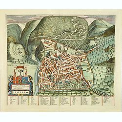
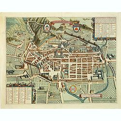
Spoleto.
A beautifully engraved and richly decorated town-plan of Spoleto. With a key (1-87) in lower right corner referring to the principal places of interest in the town. From ...
Date: Amsterdam, 1663
Selling price: ????
Please login to see price!
Sold in 2012
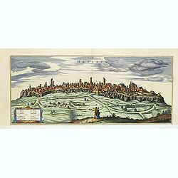
Orvieto.
A beautifully half-page engraved and richly decorated of Orvieto. With a key (1-13) in lower left corner referring to the principal places of interest in the town. From ...
Date: Amsterdam, 1663
Selling price: ????
Please login to see price!
Sold in 2013
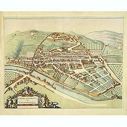
Forum Sempronii vulgo Fossombrone.
A beautifully engraved and richly decorated town-plan of Fossombrone. In the center the Church of Sant'Agostino still in its 14th century shape.From "Civitates Eccle...
Date: Amsterdam, 1663
Selling price: ????
Please login to see price!
Sold in 2013
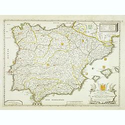
L'Espagne Divisée en ses Principaux Royaumes, dédiée a Haut et puissant Seigneur Messir Francois le Bouteiller . . .
Detailed map of Spain and Portugal, with fine title cartouche lower right.Dated 1663. A later edition with the date 1684 exists.More about [+]
Date: Paris, 1663
Selling price: ????
Please login to see price!
Sold in 2012
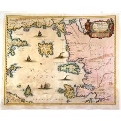
Maris Aegaei Quod hodie Archipelago Nuncupatur, Pars Septentrionalis.
Fine copperplate map featuring the Aeagean Islands of Greece. The map is decorated by a pleasant figural title cartouche and seven detailed ships in the seas. The cartogr...
Date: Amsterdam, 1663
Selling price: ????
Please login to see price!
Sold in 2015
Etats de la couronne de Pologne ou sont les Royaume de Pologne, . . . De l'Ukanie &c.
A map of modern day Poland, Lithuania, Belarus and Ukraine. Dantzick (Gdansk) clearly marked on the coast and stretching down to the Black Sea. Numerous place-names of co...
Date: Paris, 1663
Selling price: ????
Please login to see price!
Sold in 2013
Ducatus Silesiae Grotganus cum Districtu Episcopali Nissensi Delineatore Iona Sculteto, Silesio.
Attractive old colored engraved map of the duchy Wohlau in Polen. In the upper left corner dedication with coat of arms to Georg Rudolf of Liegnitz (1595–1653).Publishe...
Date: Amsterdam, 1663
Selling price: ????
Please login to see price!
Sold in 2014