Browse Listings in Europe
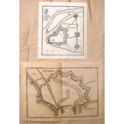
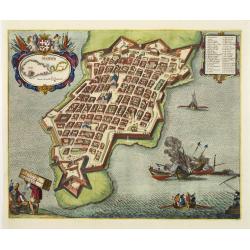
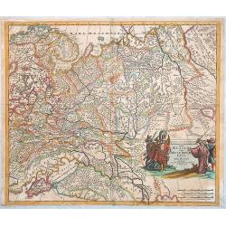
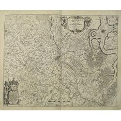
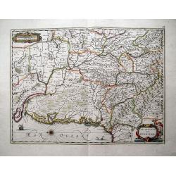
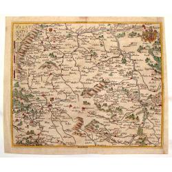
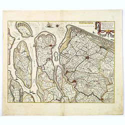
Gertruydenberg and Vlissingen (Flushing)
Striking city plans of Gertruydenberg by Caspar Merian in 1659. Caspar Merian (1627-1686) was one of the most important topographical engravers and publishers of the Ba...
Date: Frankfurt am Main, 1659
Selling price: ????
Please login to see price!
Sold in 2016
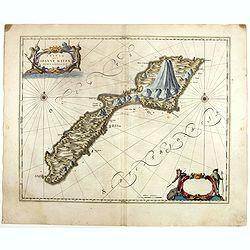
Insula que a Joanne Mayen nomen sortita est.
Jan Mayen is an isolated island in the northern Atlantic, lying between 70-72° North and 8-9° West, about 550 kilometers northeast of Iceland and 500 kilometers east of...
Date: Amsterdam, 1659
Selling price: ????
Please login to see price!
Sold in 2025
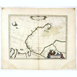
Nova Zemla.
The Dutch were the most persistent searchers after the north-east Passage, whether to the north of Novaya Zemlya (whose west coast is shown in detail) or through what the...
Date: Amsterdam, 1659
Selling price: ????
Please login to see price!
Sold in 2025
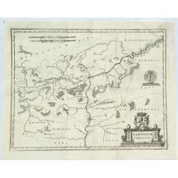
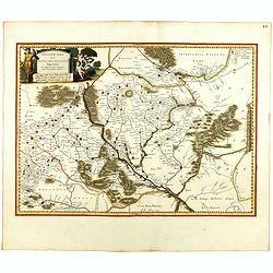
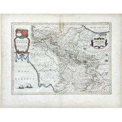
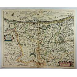
Namurcum Comitatus.
A fine map of the surrounding area around Namur, Belgium, part of the Spanish Netherlands. The map with the Sambre and Meuse rivers and other places like Dunant. It feat...
Date: Frankfurt, 1659
Selling price: ????
Please login to see price!
Sold in 2018
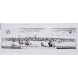
Amsterdam.
A panoramic view of the town from 't IJ.
Date: Frankfurt, 1659
Selling price: ????
Please login to see price!
Sold in 2021
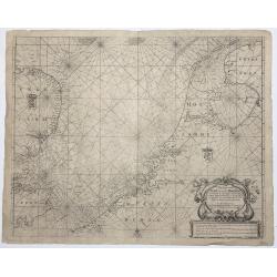
Pas Caert van Texel tot aen de Hoofden.
An attractive chart of the North Sea. Hendrick Doncker was one of the leading Amstrdam-based publshers of sea-atlases and sea charts
Date: Amsterdam, 1659
Selling price: ????
Please login to see price!
Sold in 2023
Ukrainae pars quae Kiovia Palatinatus.
This is a scarce Joan Blaeu first edition of the map of the Kiev region of Ukraine and vicinity. Signature of Joan Blaeu in the lower part of the map. This map was origin...
Date: Amsterdam, ca. 1660
Selling price: ????
Please login to see price!
Sold
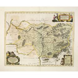
Champaigne et Brie etc.
A good engraved map of Champagne-Ardennes area, embellished with decorative title cartouche and scale cartouche with putti and surveying instruments. Paris, Metz, Reims, ...
Date: Amsterdam, 1660
Selling price: ????
Please login to see price!
Sold in 2011
![Harlemum vulgo Haerlem. [Haarlem]](/uploads/cache/15745-250x250.jpg)
Harlemum vulgo Haerlem. [Haarlem]
Fine plan of Haarlem. Lower left a numbered key (1-67).From JANSSONIUS RARE town book of the Netherlands. Copied after the plan of Blaeu, but much rarer.
Date: Amsterdam 1660
Selling price: ????
Please login to see price!
Sold
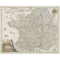
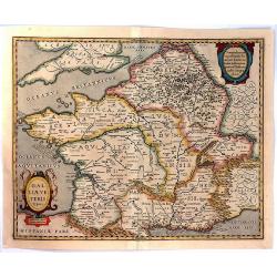
Gallia. Nova et accurata descriptio vulgo Royaume de France.
Fine map of France with in upper right corner the coats of arms of France.
Date: Amsterdam, 1660
Selling price: ????
Please login to see price!
Sold in 2011
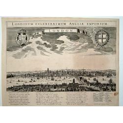
London. Londinum celeberrimum Angliae Emporium.
A rare panoramic view of London with over the whole length of the lower part 3 columns of poems in Latin, Dutch and French and a numbered key 1-43 to the principal buildi...
Date: Amsterdam, 1660
Selling price: ????
Please login to see price!
Sold
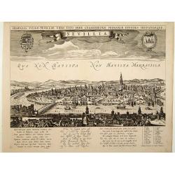
Sevillia.
A rare panoramic view of Seville with over the whole length of the lower part 3 columns of poems in Latin, Dutch and French and a numbered key 1-28 to the principal build...
Date: Amsterdam, 1660
Selling price: ????
Please login to see price!
Sold
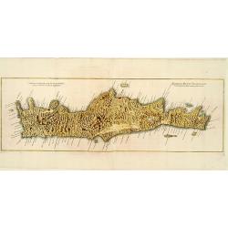
Genuina delineatio insulae Cretae..
A beautifully engraved map of Crete.
Date: Frankfurt 1660
Selling price: ????
Please login to see price!
Sold
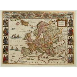
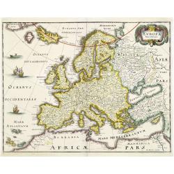
Europa recens descripta a Guilielmo Blaeuw.
On either side columns depicting the manner of dress in the major countries of Europe, surmounted by nine city views and plans. For European mapmakers their own continent...
Date: Amsterdam, 1660
Selling price: ????
Please login to see price!
Sold
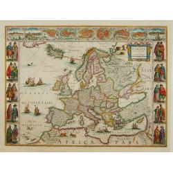
Europa recens descripta a Guilielmo Blaeuw.
On either side columns depicting the manner of dress in the major countries of Europe, surmounted by nine city views and plans. For European mapmakers their own continent...
Date: Amsterdam 1660
Selling price: ????
Please login to see price!
Sold
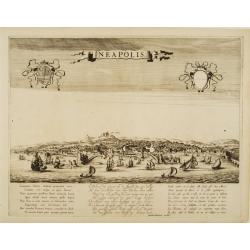
Neapolis.
A rare panoramic view of Naples with over the whole length of the lower part 3 columns of poems in Latin, Dutch and French.Published by Dancker Danckerts (1634-1666)Colle...
Date: Amsterdam, 1660
Selling price: ????
Please login to see price!
Sold
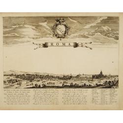
Roma.
A rare panoramic view of Rome with over the whole length of the lower part 3 columns of poems in Latin, Dutch and French and a numbered key 1-42 to the principal building...
Date: Amsterdam, 1660
Selling price: ????
Please login to see price!
Sold
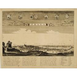
Praga.
A rare panoramic view of Prague with over the whole length of the lower part 3 columns of poems in Latin, Dutch and French and a numbered key 1-34 to the principal buildi...
Date: Amsterdam, 1660
Selling price: ????
Please login to see price!
Sold
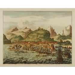
Het veroveren der stadt Allegona in 't eylandt groot Canaria, in den Jaere MDXCIX.
The town Las Palmas on Gran Canaries taken by a Dutch fleet in 1649
Date: Netherlands c.1660
Selling price: ????
Please login to see price!
Sold
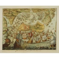
Het innemen van Cadix, geschiedt in den Jaere 1596.
Engraving of the capture and sacking of Cadiz by an English fleet under the Earl of Essex, Lord Howard of Effingham and Francis Vere. The harbour is literally filled with...
Date: Netherlands c.1660
Selling price: ????
Please login to see price!
Sold
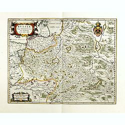
Carte de la grande Russie ou Moscovie..
Uncommon map centred on Moscow from the first folio French produced world atlas. Prepared by P.du Val and engraved by A.Peyrounin.Pierre Mariette purchased in 1644 the bu...
Date: Paris 1660
Selling price: ????
Please login to see price!
Sold
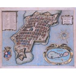
Valetta Civitas Nova Maltae olim Millitae.
A beautifully engraved and richly detailed birds-eye plan of the harbour and city of Valletta seen from the northwest. Left hand corner map of Malta and Gozo with decorat...
Date: Amsterdam, ca. 1660
Selling price: ????
Please login to see price!
Sold in 2020
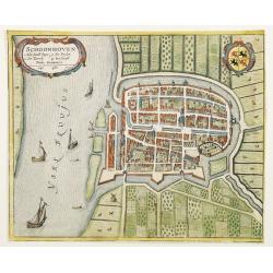
Schoonhoven.
A bird's eye view of the town of Schoonhoven. With short key list inside the title cartouche.Latin text on verso.
Date: Amsterdam, 1660
Selling price: ????
Please login to see price!
Sold in 2010
EUROPA Nova delineatio.
Decorative map of Europe, after Blaeu, depicting the mythical island of Friesland.
Date: Frankfurt, 1660
Selling price: ????
Please login to see price!
Sold in 2011
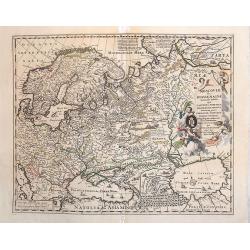
Moscoviae seu Russiae Magnae.
Map showing Russia, eastern Europe including Scandinavia.
Date: Amsterdam, c. 1660
Selling price: ????
Please login to see price!
Sold in 2013
Novissima et Accuratissima Totius Russiae vulgo Moscoviae tabula a Justo Danckerts, Amstelodami
It covers the entire Russia of early 1600s, from Novaya Zemlya to northern shores of the Black Sea and the Caspian Sea and from the Chernigov lands to the Urals. With th...
Date: Amsterdam, 1660
Selling price: ????
Please login to see price!
Sold in 2013
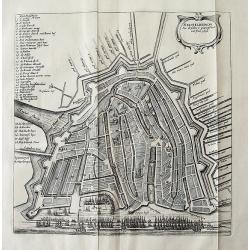
![[Waterland, Purmer, and Bijlmer] Kaarte vande Buycker-slooter, Broecker ende Belmer Meeren in Water-land Gemeten door Mr. SN Boonacker. . .](/uploads/cache/11504-250x250.jpg)
[Waterland, Purmer, and Bijlmer] Kaarte vande Buycker-slooter, Broecker ende Belmer Meeren in Water-land Gemeten door Mr. SN Boonacker. . .
Five maps on one sheet. Showing the polders of De Zype, De Purmer, De Wormer, De Beemster and a map of Waterland, including de Bylmermeer and Monnekedam. Showing the Noor...
Date: Amsterdam, 1660
Selling price: ????
Please login to see price!
Sold in 2019
Valletta citta nova di Malta.
Exceptional, early view of Valletta and Malta.
Date: Frankfurt, 1660
Selling price: ????
Please login to see price!
Sold in 2013
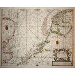
Pas Caert van Texel tot aen de Hoofden.
Very scarce and handsome sea chart of the coast of Friesland to France and at the other side of the Channel, England. It is richly embellished with rhumb lines, a half co...
Date: Amsterdam, 1660
Selling price: ????
Please login to see price!
Sold in 2008
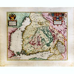
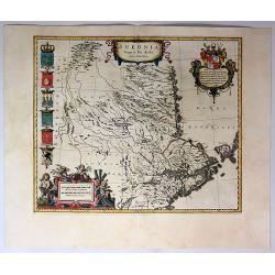
Magnus Ducatus Finlandiae Auct. Andrea Bureo Succo.
The first printed survey map of Finland, composed by the Swedish cartographer Anders Bureus (1571-1661). The map was published in 1662 in the second volume of Joan Blaeus...
Date: Amsterdam, 1660
Selling price: ????
Please login to see price!
Sold in 2015
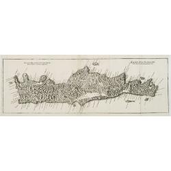
Genuina delineatio insulae Cretae..
A beautifully engraved map of Crete.
Date: Frankfurt, 1660
Selling price: ????
Please login to see price!
Sold in 2008
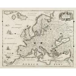
EUROPA Nova delineatio.
Decorative map of Europe, after Blaeu, depicting the mythical island of Friesland.
Date: Frankfurt, 1660
Selling price: ????
Please login to see price!
Sold in 2008
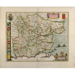
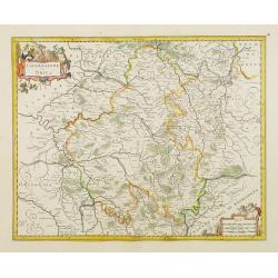
Essexia Comitatus
Outstanding attractive map of the country of Essex in UK. Showing London in the lower left corner. color is gold heightened, with king coats of arms and family coats of a...
Date: 1660
Selling price: ????
Please login to see price!
Sold in 2008
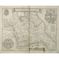
Galloflandria, in qua Castellaniae Lilana, Duacena, & Orchiesia, cum dependentibus, necnon Tornacum, & Tornacesium. Auctore Martino Doue Gallo-Flandro.
Map of French Flanders. Blank on verso. A finely engraved map from the most important Dutch map publishers of the 17th century. The plate was acquired by the Blaeu's from...
Date: Amsterdam, 1660
Selling price: ????
Please login to see price!
Sold in 2019
Flandriae Partes duae quarum altera proprietaria . . .
No text on verso.! A very detailed map with Gent in the center. Lower right corner Antwerp and Vlissingen in top right. At bottom left a very decorative cartouche with a ...
Date: Amsterdam, ca. 1660
Selling price: ????
Please login to see price!
Sold in 2009
Dioecesis Leodiensis Accurata Tabula.
Detailed map of Belgium taken from H. Hondius map and updated. Shows the river Maas, part of Belgium next to Brabant. Including the towns of Liege, Maastricht, Namur and ...
Date: Amsterdam, ca.1660
Selling price: ????
Please login to see price!
Sold in 2009
Attica Megarici, Corinthiaca, Boeotia, Phocis Locri.
Fine copperplate engraving of Attica and the surrounding regions with the cities of Athens, Thebes, Opus, and Corinth accentuated. The map is graphically engraved to illu...
Date: Amsterdam 1660
Selling price: ????
Please login to see price!
Sold in 2009
Fretum Nassovium vulgo de Straet Nassou.
Decorative map of the Nassau Strait, from the Atlas Major. Includes 2 compass roses, sailing ships, rhumb lines and 2 elaborate cartouches. Latin text below and on verso.
Date: Amsterdam, 1660
Selling price: ????
Please login to see price!
Sold in 2009
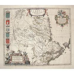
Sueonia Proprie fie dicta.
A very decorative map of eastern Sweden. Several beautiful cartouche are displayed. The left side is adorned with municipal code of arms.
Date: Amsterdam, 1660
Selling price: ????
Please login to see price!
Sold in 2009
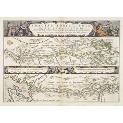
Tractus Borysthenis vulgo Dniepr et Niepr Dicti, A Civitate Czyrkassii as ostia et Ilmien lacum, per quem in Pontum Euxinium se exonerat . . .
This superb map shows the upper part of the Dnieper River in two horizontal strips, the upper map with a compass rose orienting the map, west to the top. It is richly emb...
Date: Amsterdam, 1660
Selling price: ????
Please login to see price!
Sold in 2009
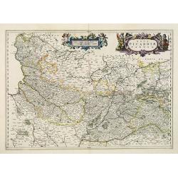
Nova Picardiae Tabula.
Detailed map of the northern part of France, including the area east of Calais till the Ardennes. Published in Joan Blaeu's "Atlas Maior".More about Joan Blaeu ...
Date: Amsterdam, 1660
Selling price: ????
Please login to see price!
Sold
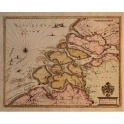
Zeelandia Comitatus.
Map of the Province of Zeeland, with its many islands and peninsulas. Major cities, small villages, and some of the natural features are named. Development over time has ...
Date: Francfurt, 1660
Selling price: ????
Please login to see price!
Sold in 2009
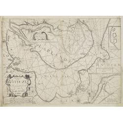
Pascaerte vande Witte-Zee. Nieulijkcx beschreve door Jacob Aertzen Colom.
Very rare chart wit insets of "De Riviere Dwina vande mont of tot de Stadt Archangel toe", and "Lombascho nae't leue ontworpen" and "Swetenoes, m...
Date: Amsterdam, 1660
Selling price: ????
Please login to see price!
Sold in 2010
Contado di Molise et Principato Ultra. . .
Map of southern Italy focusing on the county of Molise and the surrounding principalities of Ultra, Capitanata and Lavoro. Each was an administrative unit under the Kingd...
Date: Amsterdam, c. 1660
Selling price: ????
Please login to see price!
Sold in 2010
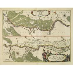
Tractus Borysthenis vulgo Dniepr et Niepr Dicti, à Kiovia ufque ad Bouzin.
This superb map shows the upper part of the Dnieper River in two horizontal strips, the upper map with a compass rose orienting the map, west to the top. It is richly emb...
Date: Amsterdam, 1660
Selling price: ????
Please login to see price!
Sold
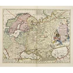
Moscoviae seu Russiae Magnae . . .
Map showing the eastern Europe and including Scandinavia.
Date: Amsterdam, c. 1660
Selling price: ????
Please login to see price!
Sold in 2011

Hollandia Comitatus.
Orientated west to the top of the sheet, this presents the County of Holland in the classical orientation for seventeenth-century maps, with Amsterdam at the center. The ...
Date: Amsterdam, 1660
Selling price: ????
Please login to see price!
Sold in 2024
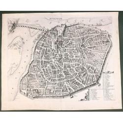
Avignon.
This rare bird's-eye plan depicts Avignon situated on both banks of the Sorgue River. A key locating 45 important sites is enclosed in the decorative cartouche at bottom ...
Date: Amsterdam, 1660
Selling price: ????
Please login to see price!
Sold in 2011
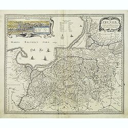
Tabula Prussiae eximia cura conscripta per Casparum Henneberch ..
Very fine and uncommon map of Prussia, prepared by Caspar Henneberger (1592-1600) in 1576. Engraved by Abraham Goos. In upper left corner inset view of Köningsberg (Kali...
Date: Amsterdam, 1660
Selling price: ????
Please login to see price!
Sold in 2013
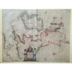
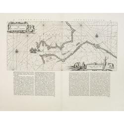
Pascaart vant Canaal, Tusschen Engelant en Vrancryck, alsmede ge heel Ierlant en Schotlant.
HEIGHTENED WITH GOLD LEAF. A beautifully colored chart of the coastal waters around the British Isles, northern France, and Ireland. With north oriented to the right, dec...
Date: Amsterdam, 1660
Selling price: ????
Please login to see price!
Sold in 2016
AMSTELREDAM Soo deselue is geweest tot int Jaer 1612
Rare town plan of Amsterdam showing the city in 1612. Very detailed plan showing buildings, canals, streets, and numerous sailing ships in the port. Embellished wit...
Date: Amsterdam, c1660
Selling price: ????
Please login to see price!
Sold in 2011
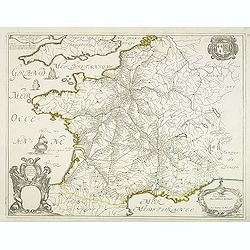
Carte Géographique des Postes qui traversent la France.
Attractive map of France shows post road mapspost routes connecting major cities, towns and harbors. Depicts sailing vessels in the British Channel and the Bay of Biscay ...
Date: Paris, 1632-1660
Selling price: ????
Please login to see price!
Sold
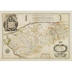
Carte du Duché et Pairie de Thouars dediée a Tres-Haut et Tres Puissant Prince Henri-Charles de la Tremoille . . .
Scarce map of the Touars Duchy with a beautiful coat of arms upper left and a title cartouche on center right. A key and a scale cartouche lower right. With a dedication ...
Date: Paris, 1660
Selling price: ????
Please login to see price!
Sold in 2013
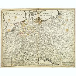
Carte generalle d'allemaigne nouvellement misse en françois et Ampliffiée de tous les Royaumes. . .
Attractive and rare map of Germany, the Low Countries, Austria, Switzerland and part of Poland.
Date: Paris, 1632-1660
Selling price: ????
Please login to see price!
Sold in 2017
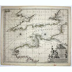
Manica, gallis La Manche, et belgis Het Canaal.
Chart of the English Channel. Stretching from "Belle Isle" lower center, to Cardigan, top left- and Colchester, top right-hand side.
Date: Amsterdam, 1660
Selling price: ????
Please login to see price!
Sold in 2014
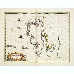
Spitsberga.
Blaeu's map of Spitsbergen was based on the Muscovy Company's map of 1625, but the north coast is completely new. It makes the heads of Wiche sound (Liefde bay) and Wyde ...
Date: Amsterdam, 1660
Selling price: ????
Please login to see price!
Sold in 2016
Il territorio Vicentino delineato per Angelo Gio. Novello, Agrimensor et intagliato da Marco Boschini.
Rare two-sheet map centered on Vicenza, situated in between Venice and Verona. North of Bassano de Grappa and Schio dramatic rendering of the mountains. The most southern...
Date: Venice, ca.1660
Selling price: ????
Please login to see price!
Sold in 2012
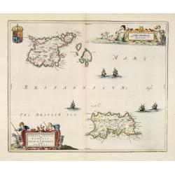
Sarnia Insula vulgo Garnsey et Insula Caesarea venacule Jarsey.
Very fine map depicting the English islands Jersey and Guernsey. Decorative cartouche with a shepherd, a shepherdess and sheep.The crown on top of the coat of arms height...
Date: Amsterdam, 1660
Selling price: ????
Please login to see price!
Sold in 2014
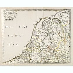
Provinces unies des Pays Bas. Par N. Sanson d'Abbeville. . .
Fine map of the present-day Netherlands. This edition carries un unfinished date "166 " and was engraved by R.Cordier Abbauil.Nicolas Sanson was to bring about ...
Date: Paris, after 1660
Selling price: ????
Please login to see price!
Sold in 2014
Description du Guienne.
Map of the Gascogne region, Aquitaine, including the coast of the Bay of Biscay, Bordeaux, Bayonne, San Sebastian, Bergerac, and Toulouse. North orientated to the left. ...
Date: Amsterdam, c1660
Selling price: ????
Please login to see price!
Sold in 2013
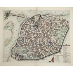
Avignon.
This rare bird's-eye plan depicts Avignon situated on both banks of the Sorgue River. A key locating 45 important sites is enclosed in the decorative cartouche at bottom ...
Date: Amsterdam, 1660
Selling price: ????
Please login to see price!
Sold in 2014
Ducatus Silesiae Grotganus cum Districtu Episcopali Nissensi Delineatore Iona Sculteto, Silesio.
Attractive old colored engraved map of Upper Silesia prepared by Joanus Scultetus, a Silesian cartographer (1603-1664) and published by J. Janssonius. Showing the area ar...
Date: Amsterdam, 1660
Selling price: ????
Please login to see price!
Sold in 2015
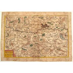
Austria Archducatus.
Quaint map of the Duchy of Austria along the Danube River. Features block cartouche.Matthäus Merian (1593 – 1650) was a Swiss -born engraver who worked in Frankfurt fo...
Date: Frankfurt, 1660
Selling price: ????
Please login to see price!
Sold in 2016
Palatinatus Rheni.
Striking map of the Palentine region of Germamy featuring the cities of Worms, Heydleberg and Kobelberg. A wonderful coat of arms cartouche with three lions decorates the...
Date: Frankfurt, 1660
Selling price: ????
Please login to see price!
Sold in 2015
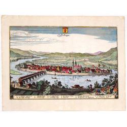
Secfingen.
Hand-colored copper engraved aerial view of Sefingen, Austria. Featured places on the view include Schonawer hoffe, sreinerne Rhein bruck and Gallen Kirchl on the Rhenus ...
Date: Frankfurt, 1660
Selling price: ????
Please login to see price!
Sold in 2013
Russiae, vulgo moscoviae dictae, pars occidentalis.
A finely engraved depiction of the area from Estonia to Moscow. The map is based on the travels of Isaac Massa, who visited Moscow in the early 1600s and thus was in the ...
Date: Amsterdam, ca. 1660
Selling price: ????
Please login to see price!
Sold in 2014
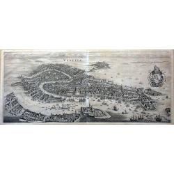
Venetia.
This famous bird's-eye town view of Venice and the lagoon area (Murano, Burano, Torcello etc.) is considered one of the influential of the time. It depicts in details the...
Date: Frankfurt, 1660
Selling price: ????
Please login to see price!
Sold in 2014
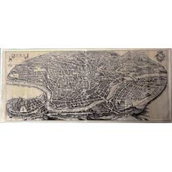
Roma.
This large, famous bird's-eye town view of Rome is considered one of the most influential of the time.It depicts in details the city's architectural landmarks. Extremely ...
Date: Frankfurt, 1660
Selling price: ????
Please login to see price!
Sold in 2014
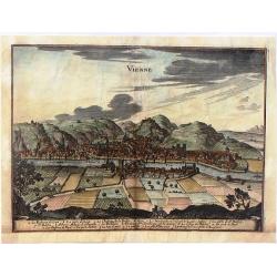
Vienne.
Striking view of the town and harbor of Vienne, France. Matthaus Merian (1593-1650) was a Swiss engraver and one of the most prolific engraver's of town views in the 17t...
Date: Frankfurt, 1660
Selling price: ????
Please login to see price!
Sold in 2015

Patriae Antiuae Inter Iuly et Caroli Magni Caesarium Romanorum Tempora Descriptio
An iInteresting map by Jan Janssonius of the “Low Countries and Northern Germany”. The compass rose orients this map with north to the right. The map describes the p...
Date: Amsterdam, 1660
Selling price: ????
Please login to see price!
Sold in 2016
Galliae Veteris Typus.
A pleasing Latin map of France during Roman times, based on Ortelius' map, which in turn was based on ancient geographical sources. The map is filled with detail and anci...
Date: Amsterdam, 1660
Selling price: ????
Please login to see price!
Sold in 2016
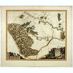
Ukrainae pars quae Pokutia Vulgo dicitur.
This is a scarce map of the western parts of Ukraine and vicinity, covering the Carpathian Mountains and extending eastward along the Dniester River to Moldova. Includes ...
Date: Amsterdam, ca. 1660
Selling price: ????
Please login to see price!
Sold in 2017
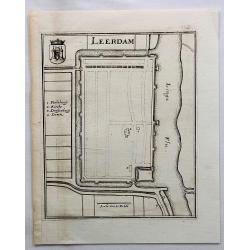
Leerdam.
Small map of fortified Leerdam, located in Gelderland, Holland.
Date: Frankfurt, ca. 1660
Selling price: ????
Please login to see price!
Sold in 2017
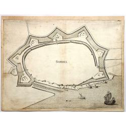
Bommel.
Den Bommel is a village in the Dutch province of South Holland. It is a part of the municipality of Goeree-Overflakkee. This town view is detailed especially in regard to...
Date: Frankfurt, 1660
Selling price: ????
Please login to see price!
Sold in 2018
Sueonia Proprie Sie Dicta.
A very decorative map of eastern Sweden. Several beautiful cartouches are displayed. The left side is adorned with six municipal code of arms. There are a total of six pu...
Date: Amsterdam, 1660
Selling price: ????
Please login to see price!
Sold in 2019
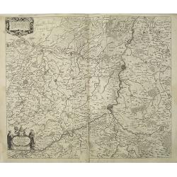
Comitatuum Boloniae et Guines Descriptio. / Bolonia & Guines Comitatus. / Territorium Metense . .
[Three maps] The first of this handsome set of maps has west is orientated to the top. Very fine copper engraved map by one of the acknowledged masters of seventeenth cen...
Date: Amsterdam, ca. 1620 - 1660
Selling price: ????
Please login to see price!
Sold in 2018
Delflandia, Schielandia. . .
This detailed road map shows the estuary of the River Maas and extends.
Date: Amsterdam, ca. 1660
Selling price: ????
Please login to see price!
Sold in 2017
Pars Flandriae Teutonicae.
A fine map of Flemish Flanders with the city of Dunkerque shown and a huge fleet of 39 ships. The interior is well engraved with forests and towns, and extends to the Lys...
Date: Amsterdam, 1660
Selling price: ????
Please login to see price!
Sold in 2018
Taurica Chersonesus.
A copper engraved map of the central Ukraine from the "Atlas Minor" (Gerhard Mercator / Jodocus Hondius). Extends from Cherkassy to Crimea and the Sea of Azov. ...
Date: Amsterdam, ca. 1609 -1660
Selling price: ????
Please login to see price!
Sold in 2018
Diocese, Prevoste, et Eslection de Paris . . .
A good engraved map of Ile de France region, centered on Paris.
Date: Paris, 1660
Selling price: ????
Please login to see price!
Sold in 2020