Browse Listings in Europe
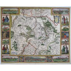
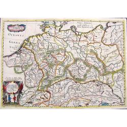
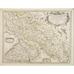
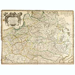
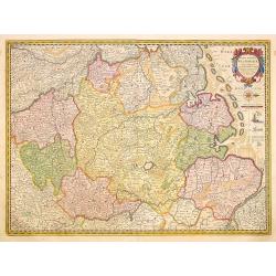
Palatinatus Rheni Nova et Accurata Descriptio
Showing the Rheinland-Pfalz region. With city views of Metz and Frankfurt-am-Main, Worms, Speyer and Heidelberg, and partial views of Heidelberg Castle, the wolf fountain...
Date: Amsterdam, 1652
Selling price: ????
Please login to see price!
Sold in 2008
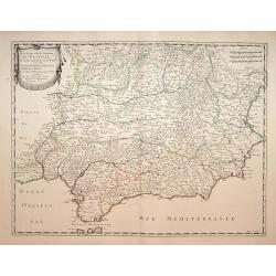
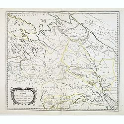
Les Etats de la couronne de Castille.. Andalousie..
Map of Andalusia, with original or early outline hand-color. Numerous place-names of counties, cities, towns, physical features. Prepared by N.Sanson.
Date: Paris, 1652
Selling price: ????
Please login to see price!
Sold in 2021
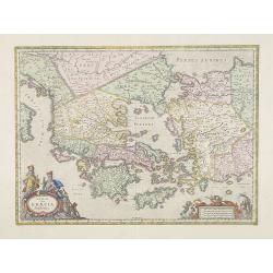
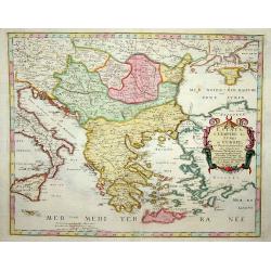
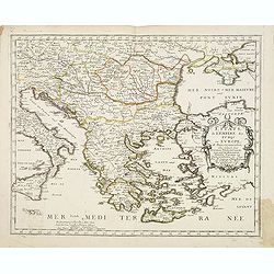
Hellas Seu Graecia Sophiani.
A decorative detailed map of Ancient Greece and the western part of Turkey and Macedonia.
Date: Amsterdam, 1652
Selling price: ????
Please login to see price!
Sold in 2009
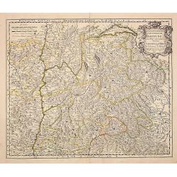
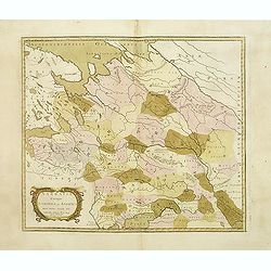
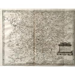
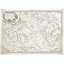
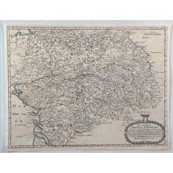
Le gouvernement general du Daufine, et.. La Savoye. . .
Fine map of south eastern part of France and part of Switzerland. Centered on Basle and the Alps.With manuscript number in upper right corner.Nicolas Sanson was to bring ...
Date: Paris, 1652
Selling price: ????
Please login to see price!
Sold
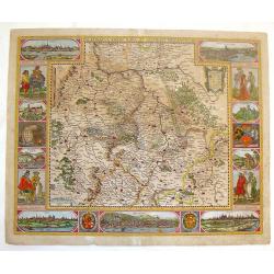
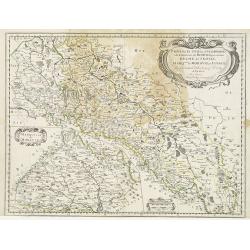
Palatinatus Rheni Nova et Accurata Descriptio.
Fine copper engraved map of the Rheinland-Pfalz region of Germany. With city views of Metz, Frankfurt-am-Main, Spier, Heidelberg and Worms. Smaller views of Heidelberg Ca...
Date: Amsterdam, 1652
Selling price: ????
Please login to see price!
Sold in 2014
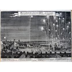
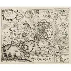
Abriß des Kayserlichen Fewerwercks Schlosses: und Barraquen. . .
Curious view of the fireworks in Nuremberg in 1650 to celebrate the peace after the Thirty Years' War. Shows the barracks and the large square with the city in the backgr...
Date: Frankfurt, 1652
Selling price: ????
Please login to see price!
Sold in 2013
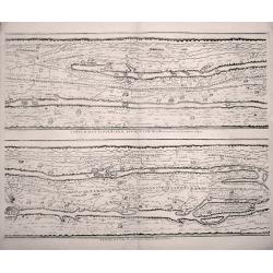
TABVLAE PEVTINGERIANAE SEGMENTVM III. à Marcomannis ad Sarmatas vsque. "Segmentvm IV. à Sarmatis vsque ad Hamaxobios
Sheet 2 of 4 from Peutinger Table, or a Roman road map of the world, "TABVLAE PEVTINGERIANAE SEGMENTVM III. à Marcomannis ad Sarmatas vsque", Segmentvm IV. a&a...
Date: Amsterdam, 1652
Selling price: ????
Please login to see price!
Sold in 2014
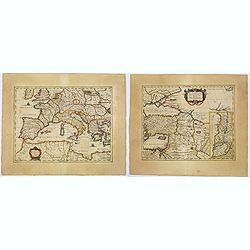
Lumen Historiarum per Occidentem. . . / Lumen Historiarum per Oreintem. . . Lumen Historiarum per Occidentem. . . / Lumen Historiarum per Orientem. . .
A pair of interesting seventeenth-century maps. The first map is an unusual 1652 map of Europe as known to the ancients by Jan Jansson. Centered on Italy, this map covers...
Date: Amsterdam, 1652
Selling price: ????
Please login to see price!
Sold in 2018
Germania Antiqua Australis...
A scarce map of central Europe with the ancient place names. Extends from modern day France until Poland, and from Denmark until Switzerland. Includes two decorative titl...
Date: Unknown, ca. 1652
Selling price: ????
Please login to see price!
Sold in 2018
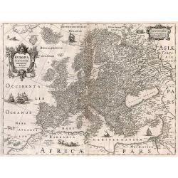
Europa exactissime descripta.
A fine map, embellished with two cartouches, several ships and a sea-monster, polar bears and lions. With French text on verso.
Date: Amsterdam, 1652
Selling price: ????
Please login to see price!
Sold in 2017
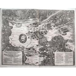
Delineatio Memorabilis Conflictus et Victoriae Lithuanorum Duce Radivilio de Cricevio et Triginta. . .
A fantastic illustration of the Battle of Loyew during the Khmelnytsky uprising in 1649. Near the site of the present-day town of Loyew in Belarus, a numerically superior...
Date: Frankfurt, ca 1652
Selling price: ????
Please login to see price!
Sold in 2018
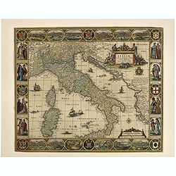
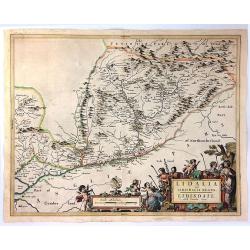
Tabula Italiae, Corsicae, Sardiniae et adjacentium Regnorum. A°1652.
This beautiful old colored engraved map is signed on plate by Nicolas Iohannis Visscher, and by the engraver Abraham Goos on lower left. The border is decorated with 12 v...
Date: Amsterdam, 1652
Selling price: ????
Please login to see price!
Sold in 2019
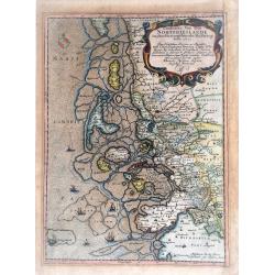
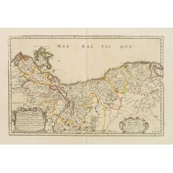
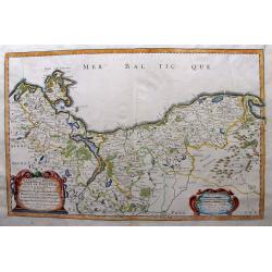
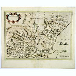
Landtcarte Von dem Nortfrieslande in dem Hertzogthumbe Sleßwig Anno 1651.
A very decorative, rare map showing part of the coastal area of the German North Sea (Nordfriesland). It includes the island of Sylt. From the rare atlas of Mejer Danckwe...
Date: Husum, 1652
Selling price: ????
Please login to see price!
Sold in 2021
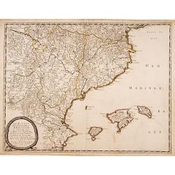
Les Etats de la couronne d'Arragon en Espagne..
"Fine map of Aragon, including Majorca, Minorca and Ibiza.This edition carries the date 1653.Nicolas Sanson was to bring about the rise of French cartography, althou...
Date: Paris 1653
Selling price: ????
Please login to see price!
Sold
Armenia Vetus In Quatuor Partes..
Uncommon map of ancient Armenia.
Date: Paris 1653
Selling price: ????
Please login to see price!
Sold
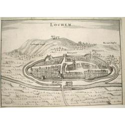
Lochem.
Nice bird's-eye view of the town of Lochem in central part of the province of Gelderland.Very detailed engraving, with the Lochemer berg in the background.Made by Nicolaa...
Date: Arnhem 1653
Selling price: ????
Please login to see price!
Sold
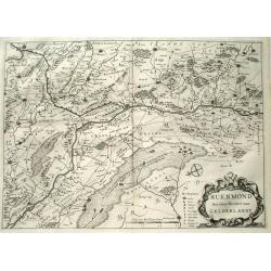
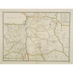
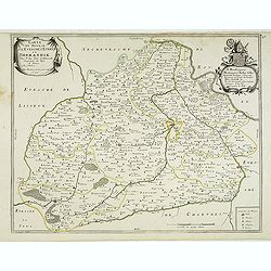
Ruermond, Het Over Vierdeel van Gelderlandt
Rare map of the southern part of the former duchy of Gelre, now a part of the Dutch province of Limburg. The map shows the area of Northern Limburg and the eastern part o...
Date: Arnhem 1653
Selling price: ????
Please login to see price!
Sold
Armenia Vetus In Quatuor Partes..
Uncommon map of ancient Armenia.
Date: Paris, 1653
Selling price: ????
Please login to see price!
Sold in 2008
Insularum Sardiniae et Corsicae Antiqua descriptio/ Insular Aliquot Aegaei Maris Antiqua descrip.
Map showing Sardinia, Corsica and Aegean Islands including Chios, Rosi, Lemnos and Lesbos. From an historical atlas by Georgius Hornius,"Accuratissima orbis antiqui ...
Date: Amsterdam, 1653
Selling price: ????
Please login to see price!
Sold in 2014
Diocese du Mans...
Published by Mariette en la Rue S. Iacques a l'Enseigne de l'Esperance. With a dedication of Mr. Christophle Justel Conseiller et Secretaire du Roy… Engraved by Michel ...
Date: Paris, 1653
Selling price: ????
Please login to see price!
Sold in 2017
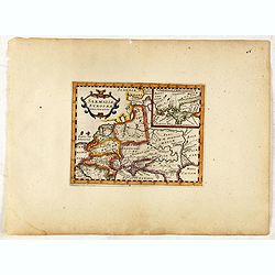
Sarmatiae Europae ae delineatio.
Scarce map of Poland, Lithuania, Russia, with inset map of Crimea. (550x670mm.)From his "Parallela geographiae veteris et novae."
Date: Paris, 1653
Selling price: ????
Please login to see price!
Sold in 2015
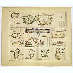
Insularum Sardiniae et Corsicae Antiqua descriptio/ Insular Aliquot Aegaei Maris Antiqua descrip.
A striking map showing Sardinia, Corsica and many of the Aegean Islands, including Chios, Rosi, Lemnos and Lesbos.From an historical / geographical Atlas by Georgius Horn...
Date: Amsterdam, 1653
Selling price: ????
Please login to see price!
Sold in 2017
Konigreich Boheim. Royaume de Boheme..
Covering Czech Republic and centered on Prague. Nicolas Sanson was to bring about the rise of French cartography, although the fierce competition of the Dutch would last ...
Date: Paris 1654
Selling price: ????
Please login to see price!
Sold in 2010
Le Tirol.. Bregentz/ Feldkirck.. Trente/ Brixen.
Fine map of Tyrol.This edition carries the date 1654.Nicolas Sanson was to bring about the rise of French cartography, although the fierce competition of the Dutch would ...
Date: Paris 1654
Selling price: ????
Please login to see price!
Sold
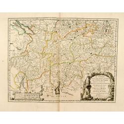
Provinces Unies, et Incorporees a la Couronne de Boheme, qui sont les Duche de Silesie, Marq sats de Moravie, et Lusace.
Two maps on one sheet. A fine map of East Poland & Lithuania. With Breslaw in the center.Nicolas Sanson was to bring about the rise of French cartography, although th...
Date: Paris 1654
Selling price: ????
Please login to see price!
Sold
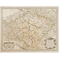
Duche de Pomeranie..
Fine map of the northern part of Poland.This edition carries the date 1654. Nicolas Sanson was to bring about the rise of French cartography, although the fierce competit...
Date: Paris 1654
Selling price: ????
Please login to see price!
Sold
Lidelia Vel Lidisdalia Regio, Lidisdail.
A map of Liddesdale, a historic district of Scotland, bordering Teviotdale to the east, Annandale to the west, and Tweeddale to the north, with the English county of Cumb...
Date: Amsterdam, 1654
Selling price: ????
Please login to see price!
Sold in 2016
Provinces unies et . . . De Silesie . . . / Marquisat de Moravie.
Two maps on one sheet. Covering Poland, the main map centered on the river Odwer with Wroclaw. In lower left corner inset map of Slovakia.This edition carries the date 16...
Date: Paris, 1654
Selling price: ????
Please login to see price!
Sold
Sarmatia Utraque Europaea et Asiatica..
The ancient map of the European part of Russia. Nicolas Sanson was to bring about the rise of French cartography, although the fierce competition of the Dutch would last ...
Date: Paris, 1654
Selling price: ????
Please login to see price!
Sold in 2011
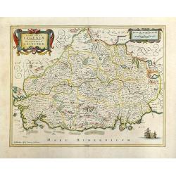
Lagenia; Anglis Leinster / The countie of Leinster.
An elegant map which includes the area westward from Dublin to the Shannon and from Waterford in the north to Drogheda. A decorative map with galleons in full sail in the...
Date: Amsterdam, 1654
Selling price: ????
Please login to see price!
Sold in 2018
Carte du Diocese de l'Evesche d'Eureux en Normandie . . .
Uncommon map of the French region Normandy with fine title cartouche upper left and dedication cartouche to Bishop Gilles Boutault, bishop of Evreux.River Seine in upper ...
Date: Paris, 1654
Selling price: ????
Please login to see price!
Sold
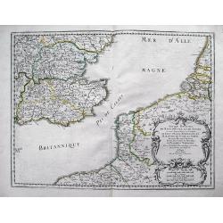
Anciens Royaumes de Kent, d'Essex, et de Sussex: ou sont Aujourdhuy les Comtés de Kent, d'Essex, Middlessex, et Hartford de Sussex, et Surrey. Avecq le Pas de Calais, et Partie des Cotes du Pays Bas, de Picardie, et Normandie.
Interesting map of the Strait of Dover / Pas de Calais. Shows the French coast from Fecamp, Dieppe, Boulogne, Calais; the Belgian Coast with Oostende, and the Dutch Coast...
Date: Paris, 1654
Selling price: ????
Please login to see price!
Sold in 2012
Sarmatia Utraque Europaea et Asiatica. . .
The ancient map of the European part of Russia with the Ukraine. Dated 1654.Nicolas Sanson was to bring about the rise of French cartography, although the fierce competit...
Date: Paris, 1654
Selling price: ????
Please login to see price!
Sold in 2014
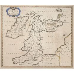
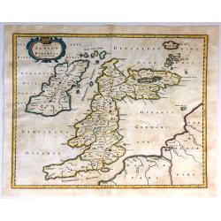
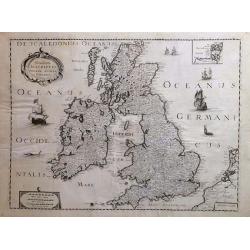
Insulae Albion et Hibernia cum minoribus adjacentibus.
This map of the British Isles during ancient times is based on the cartography of Mercator’s Ptolemaic presentation of the British Isles and Ireland, The map delineates...
Date: Amsterdam, 1654
Selling price: ????
Please login to see price!
Sold in 2014
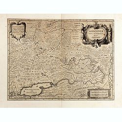
Moscoviae pars australis...
Fine example of this early map of the southern part of Russia, showing the region centered on Moscow. Prepared by Isaac Massa, a Dutch map-maker who travelled to Russia, ...
Date: Amsterdam, ca. 1654
Selling price: ????
Please login to see price!
Sold in 2015
Moscoviae pars australis...
Fine example of this early map of the southern part of Russia, showing the region centered on Moscow. Prepared by Isaac Massa, a Dutch map-maker who travelled to Russia, ...
Date: Amsterdam, ca. 1654
Selling price: ????
Please login to see price!
Sold in 2015
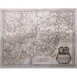
Wine Region Burgundy - Utriusque Burgundiae tum Ducatus tum Comitatus descriptio.
Decorative map of the Wine Region Burgundy. Large cartouche with coats of arms and pictorial scale of miles.
Date: Frankfurt am Main, 1654
Selling price: ????
Please login to see price!
Sold in 2015
HERTZOGTHUMB POMMERN DUCHE DE POMERANIE divise en ses Princip les Parties qui sont les Princip te de Rugue, Duche de Stettin, Pomeranie, Cassubie, et Wandalie ...
Very fine map of the northern part of Poland. Nice details of forests, villages and rivers. Two nice full color cartouches.Nicolas Sanson was to bring about the rise of F...
Date: Paris, 1654
Selling price: ????
Please login to see price!
Sold in 2015
Anciens Royaumes de Mercie et East Angles. . .
Ancient Kingdoms of Mercia and East Anglia. This is a striking map showing the ancient Saxon kingdoms of Mercia and East Anglia including the counties and shires of Chest...
Date: Paris, 1654
Selling price: ????
Please login to see price!
Sold in 2017
Insulae Albion et Hibernia Cum Minoribus Adjacentibus.
This map of the British Isles during ancient times is based on the cartography of Mercator. The map delineates and names ancient regions via hand coloring and engraved li...
Date: Amsterdam, 1654
Selling price: ????
Please login to see price!
Sold in 2016
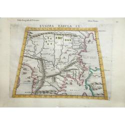
Europae Tabula IX .
A fine Ptolemaic map that covers the Balkans and includes the Bosphorus one of the earliest maps of Turkey and Macedonia. The map, drawn on a trapezoidal projection, is b...
Date: Venice, 1654
Selling price: ????
Please login to see price!
Sold in 2016
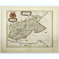
Southerlandia.
A map from the first comprehensive atlas of Scotland, published by Blaeu in 1654, after an earlier work of the region by Gordon. 'Southerlandia' is a highland region of n...
Date: Amsterdam, 1654
Selling price: ????
Please login to see price!
Sold in 2018
Glottiana Praefectura Inferior cum Baronia Glascuensi.
A fine map of the Glasgow region of Scotland. It extends from Glasgow to Lanark with Hamilton at its centre, and Kyle to Lothian. The map was drawn by Timothy Pont and su...
Date: Amsterdam, 1654
Selling price: ????
Please login to see price!
Sold in 2018
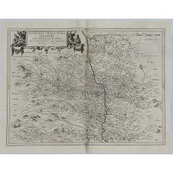
Le Barrois.
A detailed map centred on Bar-le-Duc in the province of Le Barrois. It features a decorative title cartouche with a coat of arms at the lower left. It was engraved by Je...
Date: Paris, 1654
Selling price: ????
Please login to see price!
Sold in 2019
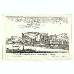
Veuë et Perspective d'une partie des Ville et Chasteau d'Avignon.
Eye-bird view of castle at Avignon and part of the town. Etching by Israel Silvestre called the Younger to distinguish him from his father, was a prolific French draftsma...
Date: Paris, 1654
Selling price: ????
Please login to see price!
Sold in 2020
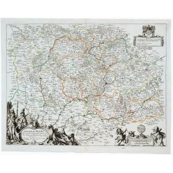
Diocese du Mans Divisee Par Doyennes Ruraux ...
Detailed fine 1654 Nicolas Sanson & Pierre Mariette's copper engraved map of the area around Le Mans in France. The map is filled with excellent topographic detail on...
Date: Paris, 1654
Selling price: ????
Please login to see price!
Sold in 2023
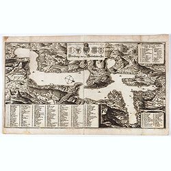
Abbildung der 4. Waldtstätten See.
View of Lake Lucerne and the surrounding land. Detailed indications of all the places and castles present in the region. Representation of mountainous terrain.. Printed f...
Date: Frankfurt, 1654
Selling price: ????
Please login to see price!
Sold in 2021
Fifae Vicecomitatus. The Sherifdome of Fyfe.
A decorative Scottish county map by Blaeu. It shows the whole Fife peninsula with Edinburgh at bottom of the map. Published in his Atlas Novus Vol. 5 in 1654, The map is ...
Date: Amsterdam, 1654
Selling price: ????
Please login to see price!
Sold in 2023
Vistus Insula, vulgo VII ST, cum aliis minoribus
This scarce map of Barra and North and South Uist in the Outer Hebrides of Scotland by Joan Blaeu was based on the surveys done by Timothy Pont some half-century earlier....
Date: Amsterdam, 1654
Selling price: ????
Please login to see price!
Sold in 2023
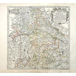
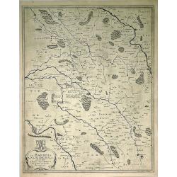
Bayern Baviere..
"Covering southern part of Germany, centered on Regensburg, Augsburg, Munich, etc. Engraved by R.Cordier Abbauil. Nicolas Sanson was to bring about the rise of Frenc...
Date: Paris 1655
Selling price: ????
Please login to see price!
Sold
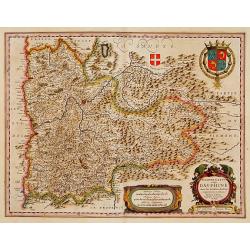
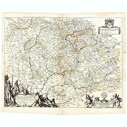
Delphinatus vulgo DAUPHINÉ...Par Jean de Beins.
Beautiful map of a province of France by the most famous map publisher. Centered on Grenoble. Also showing Lyon, Chambéry, Briançon, Vienne, Valence, etc. In the lower ...
Date: Amsterdam 1644-1655
Selling price: ????
Please login to see price!
Sold
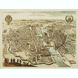
Paris Wie Solche A.° 1620. im Weffen geftanden.
Bird's eye view of Paris presenting the town's coat of arms on the upper left corner and the coat of arms of France on the upper right corner.
Date: Francfort-sur-le-main, 1655
Selling price: ????
Please login to see price!
Sold
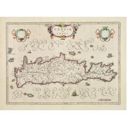
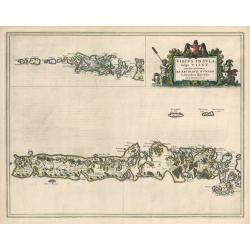
Candia, olim Creta.
One of the most beautiful ever produced maps of Crete.
Date: Amsterdam 1655
Selling price: ????
Please login to see price!
Sold
Ducatus Silesiae Glogani Vera Delineatio..
Centered on Glogàw. Decorative map prepared by Jonas Scultetus, a Silesian cartographer (1603-1664).
Date: Amsterdam, 1655
Selling price: ????
Please login to see price!
Sold in 2017
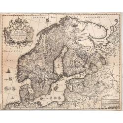
Suecia, Dania et Norvegia, Regna Europae Septentrionalia.
Decorative map of Scandinavia.
Date: Amsterdam, 1655
Selling price: ????
Please login to see price!
Sold in 2014
Galliae Nouael accurata descriptio Vulgo Royaume de France. . .
A map of France.From Merian's Topographia Galliae. . . . In lower left corner fine title cartouche, and upper right coat of arms of France.
Date: Frankfurt, 1655
Selling price: ????
Please login to see price!
Sold
Gouvernement General de L'Isle de France et Pais Circomvoisins.
Map of regions in France by Casper Merian from his Topographia Galliae. Overall a wonderfully detailed composition which features major cities such as Paris, Chartres, an...
Date: Frankfurt, 1655
Selling price: ????
Please login to see price!
Sold in 2010
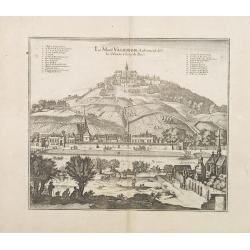
Le Mont Valerien. Autrement dit-Le Calvaire. 2 lieus de Paris.
A view of the Mount Valerien in the Paris vicinities. Very well engraved with excellent detail. Plan for the Mont Valérien Calvary near Paris. As early as the 15th centu...
Date: Frankfurt, 1655
Selling price: ????
Please login to see price!
Sold in 2013
Estats de L´Empire des Turqs en Europe et Pays circomvoisins....
Map of Greece with all islands, partly showing Italy and Turkey.
Date: Paris, 1655
Selling price: ????
Please login to see price!
Sold in 2014
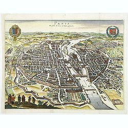
Paris Wie Solche A.° 1620. im Weffen geftanden.
Decorative and important town-plan of Paris with coats of arms of the city.
Date: Frankfort, 1655
Selling price: ????
Please login to see price!
Sold
Estats de L'Empire des Turqs en Europe et pays circomvoisins.
Fine map of Greece, including lower part of Italy, western part of Turkey and the Black Sea with Crimea.This edition carries the date 1655.Nicolas Sanson was to bring abo...
Date: Paris, 1655
Selling price: ????
Please login to see price!
Sold in 2013
Germano-Sarmatia in qua Populi maiores Venedi et Aetiaei Peucini et Bastarnae in minores Populos divisi ad hodiernam locorum et Regionum
Fine map of ancient Poland and the whole of Eastern Europe, showing part of the Baltic and Gulf of Riga, including the modern countries of Poland, Lithuania, Ukraine and ...
Date: Paris, 1655
Selling price: ????
Please login to see price!
Sold in 2013
Novissima descriptio Angliae Scotiae et Hiberniae.
A striking and highly detailed copper engraved map of British Islands, including United Kingdom, Ireland and portions of Netherlands. The map gives several details concer...
Date: Paris, 1655
Selling price: ????
Please login to see price!
Sold in 2018
Diocese, Prevoste, et Eslection de Paris le Diocese Divise en Archipbreis .....
Fine copper engraved map of the Island of Paris. Adorned by a striking strap title cartouche.By Matthaus Merian, considered to be the grandmaster of the city view. He inh...
Date: Frankfurt, 1655
Selling price: ????
Please login to see price!
Sold in 2017
Estats De La Couronne De Pologne ou sont les Royaume de Pologne, Duches et Provinces De Prusse, Cuiave, Mazovie, Russie Noire &c.
First state of Sanson's map of modern day Poland, Lithuania, Belarus and Ukraine. Dated 1655 and revised several times over the next 50 years. Engraved by J.Sommer.Nicola...
Date: Paris, 1655
Selling price: ????
Please login to see price!
Sold in 2016
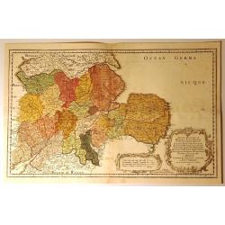
Urivsque Burgundiae tum Ducatus tum Comitatus Descriptio.
Fine copper engraved map by Matthäus Merian from “Neuwe Archontologia Cosmica” Published in Frankfurt in 1646. The map shows the French region of Burgundy with the...
Date: Frankfurt, 1655
Selling price: ????
Please login to see price!
Sold in 2018
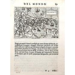
Ollandt.
A fine miniature map of Holland, including a sea-monster and several sailing ships. The map was published by Pietro Marchetti in his Il Theatro del Mondo, an Italian pir...
Date: Venice, ca. 1655
Selling price: ????
Please login to see price!
Sold in 2019
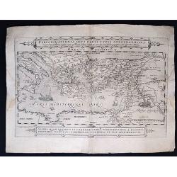
Peregrinationis Divi Pauli Typus Corographicus. . .
Peregrinationis Divi Pauli Typus Corographicus In quo & novi testamenti, in primis autem apostulorum historiae, a Sancto Luca descripta, omnia fere loca geographica, ...
Date: Paris, 1655
Selling price: ????
Please login to see price!
Sold in 2020
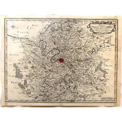
Gouvernement General D'Orleans.
A nice regional map of France showing the area around Tours and Orleans. From M. Merian's "Topographiae Galliae".Matthäus Merian the Elder (1593-1650) studied ...
Date: Frankfort, 1655
Selling price: ????
Please login to see price!
Sold in 2020
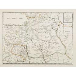
Nova Totius Westphaliae.
Shows the area between Maastricht, Dockum, Herschfelt and Hamburg. A fine copy in attractive colors.
Date: Amsterdam 1656
Selling price: ????
Please login to see price!
Sold
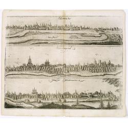
View of Colomna, Cassimogorod and Moru. ma Mordwinorum.
Three early town-views of Colomna, Cassimogorod and Mordwinorum on the Occa river on one sheet.From "Voyages en Moscovie, Tartarie et Perse, par Adam Olearius"....
Date: Paris, Abraham de Wicquefort , 1656
Selling price: ????
Please login to see price!
Sold in 2013
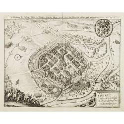
Abbildung der Statt Pilsen in Böhmen und diesselbige durch den:von Mansfeldt belägert und Eingenohmen worden. Anno 1618.
Decorative plan of the town of Pilsen.
Date: Frankfurt, 1656
Selling price: ????
Please login to see price!
Sold in 2008
Wahrhaffte Abbildung der Vesten Statt Rochelle, mit Ihren Fortificationen, und dem Königl. Läger und Schantzen Anno 1627. Obsidio Rupellae.
Decorative plan of the siege of 1627 of the town of La Rochelle.
Date: Frankfurt, 1656
Selling price: ????
Please login to see price!
Sold in 2008
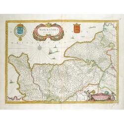
Normandia Ducatus.
Very decorative map of the Normandy coast. The map shows details of even the tiniest villages and prominently depicts the fortified cities. Numerous ships, fishing boats ...
Date: Amsterdam, 1656
Selling price: ????
Please login to see price!
Sold in 2012
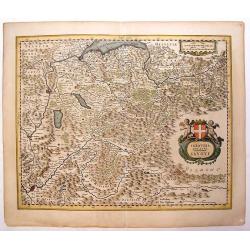
Sabaudia Ducatus Savoye
Lovely, very detailed map of Savoy with two cartouches: An ornamental title cartouche with two putti and a coat of arms and a strapwork scale cartouche. Features the two ...
Date: Amsterdam, 1656
Selling price: ????
Please login to see price!
Sold in 2013
Atrebates. Evesche d'Arras Comte d'Artois.
Fine copper engraved map of the French department of Nord-Pas-de-Calais. The map includes the cities of Douai, Lens, Cambrai and Bapaume. Very decorative ribboned title c...
Date: Paris, 1656
Selling price: ????
Please login to see price!
Sold in 2016
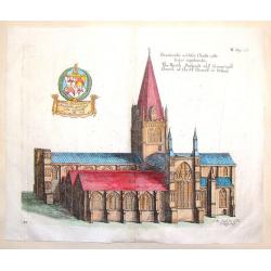
The North Prospect of ye Conuentuall Church of Christ in Oxford.
Hand-colored copper engraving of the Church of Christ in Oxford from Daniel King's "The Cathedrall & Conventuall Churches of England". King was a friend an...
Date: London, 1656
Selling price: ????
Please login to see price!
Sold in 2015
Totius Regni Hungarie et Adjacentium Regionum.
A beautiful, large, detailed map of southeastern Europe; featuring Hungary by Nicolas Visscher. Includes the regions of Northern Italy (showing the cities Bologna, Padua,...
Date: Amsterdam, 1656
Selling price: ????
Please login to see price!
Sold in 2018
Quercy olim Cadurcium.
Decorative map east to the top of the French province in the south-east of the country. With Cahors and the river Lot in the center.
Date: Amsterdam, 1656
Selling price: ????
Please login to see price!
Sold in 2020
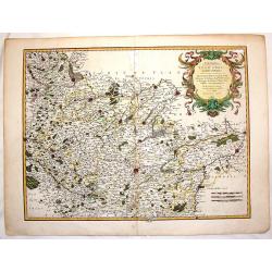
Borbonium Ducatus - Bourbonnois.
A fine map of the Bourbon in central France with nice detail of cities, villages, forests and rivers. Decorated with two beautiful cartouches flanked by musketeers and pu...
Date: Amsterdam, 1656
Selling price: ????
Please login to see price!
Sold in 2019