Browse Listings in Europe
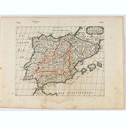
Espagne. . .
Map of Spain and Portugal prepared by N.Sanson and published by Pierre Mariette.Published in an early edition of the small Sanson atlas L'Europe Dediée a Monseigneur . ....
Date: Paris, P. Mariette, 1656
Selling price: ????
Please login to see price!
Sold in 2021
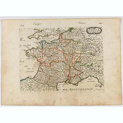
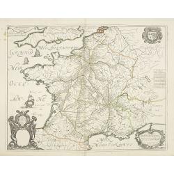
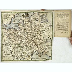
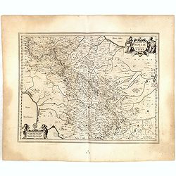
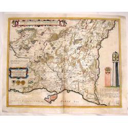
France.
Engraved map of France.
Date: Paris, 1656
Selling price: ????
Please login to see price!
Sold in 2021
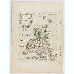
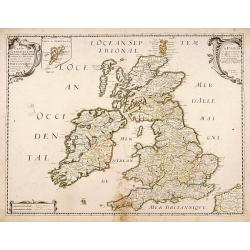
Isles Britanniques . . .
Map of Great Britain prepared by N.Sanson and published by Pierre Mariette. This is a reduced derivative of the famous Sanson map of 1650.Published in an early edition of...
Date: Paris, P. Mariette, 1656
Selling price: ????
Please login to see price!
Sold in 2025
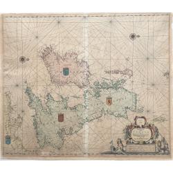
Pascaarte vant Canaal door Arnold Colom t Amsterdam op het Watter by de Nieuwe brugh inde Lichtende Colom.
This large folio, extremely decorative sea chart offered here is one of the earliest and rarest sea charts depicting the British Isles. It appeared in the famous Colom's...
Date: Amsterdam, 1656
Selling price: ????
Please login to see price!
Sold in 2022
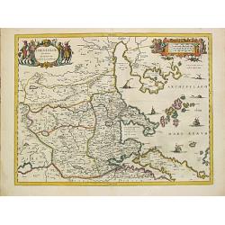
Thessaliae accurata descriptio.
A map of northeast of Greece in classical times by the hand of Johannes Laurenberg appeared in part V of Johannes Janssonius? ?Atlantis Majoris?.Embellished with two deco...
Date: Amsterdam, 1650-1657
Selling price: ????
Please login to see price!
Sold
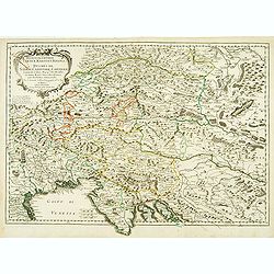
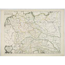
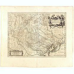
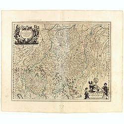
Hertzogthuber Steyer, Karnten, Krain
Covering southern part of Austria, northern part of the Gulf of Venice and part of former Yugoslavia. Nicolas Sanson was to bring about the rise of French cartography, al...
Date: Paris, 1657
Selling price: ????
Please login to see price!
Sold
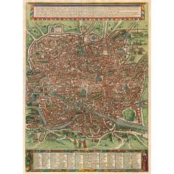
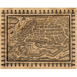
Antiquae Urbis Romae...
Large view of ancient Rome on two joined sheets. Rare. Originally engraved for Braun and Hogenberg, the plates eventually passed to Joannes Janssonius who reissued the pl...
Date: Amsterdam, 1657
Selling price: ????
Please login to see price!
Sold in 2009
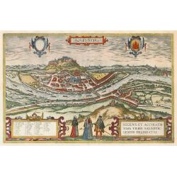
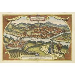
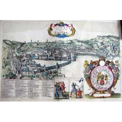
Saltzburgk.
Jansson edition of the Braun & Hogenberg of Salzburg.
Date: Amsterdam, 1657
Selling price: ????
Please login to see price!
Sold in 2009
Germania antiqua. . .
Fine map of ancient Germany, The Netherlands, Belgium, Switzerland, Austria and Poland. The map was first published by Tavernier and later by Mariette. This edition carri...
Date: Paris, 1641-1657
Selling price: ????
Please login to see price!
Sold in 2022
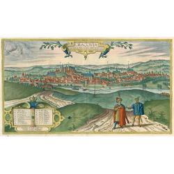
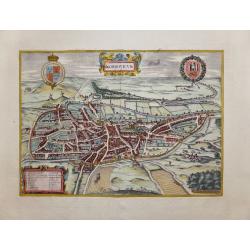
Cracovia Minoris Poloniae Metropolis.
Joannes Janssonius rare town-view of Krakow. After Braun & Hogenberg. Jansson's Theatrum Urbium was the only Dutch atlas to attempt a complete or near complete visual...
Date: Amsterdam, 1657
Selling price: ????
Please login to see price!
Sold in 2010
Buda Citerioris Hungariae Caput Regni avita sedes, vulgo Ofen.
Town-plan of the Hungarian capital of Budapest. Originally engraved for the Civitates. Compiled and written by George Braun, Canon of Cologne Cathedral. The drawings was ...
Date: Amsterdam, ca. 1657
Selling price: ????
Please login to see price!
Sold in 2013
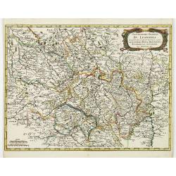
Gouvernement General du Lyonnois. . .
Very detailed map of the area Limonges and Lyon in France. Showing also Thiers, Vichy, Bourges, Vallance, Vienne. From M. Merian's famous "Topographia".
Date: Frankfurt, 1657
Selling price: ????
Please login to see price!
Sold in 2011
Lucerna Helvetiorum Vulgo Lucernn.
Very scarce original town view of Lucerne by the Bohemian master Wenceslaus Hollar who worked with Jan Jansson.Highly decorative: The view is presented with 95 (!) number...
Date: Amsterdam, 1657
Selling price: ????
Please login to see price!
Sold in 2011
Carte generale des Royaume d'Angleterre Escosse et Irlande..
Fine map of the British Isles, in a second state. The map was first published by Tavernier and later by Mariette. This edition carries the date 1640, and address of Pierr...
Date: Paris, 1640-1657
Selling price: ????
Please login to see price!
Sold in 2011
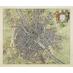
Lutetia Parisiorum Vulgo PARIS.
First state of this fine town-plan of Paris published in Joannes Janssonius Town book "Theatrum exhibens celebriores Galliae et Helvetiae urbes". This plan deri...
Date: Amsterdam, c.1657
Selling price: ????
Please login to see price!
Sold
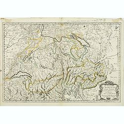
Les Suisses les Allies des Suisses et leurs Suiets. . .
Early imprint of this detailed map of Switzerland. This edition carries the date 1648 and was engraved by R.Cordier Abbauil.Nicolas Sanson was to bring about the rise of ...
Date: Paris, 1648-1657
Selling price: ????
Please login to see price!
Sold in 2013
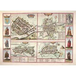
Galwaye, Dubline , Lymericke, and Corcke - Braun & Hogenberg, 1618.
Fine "carte à figures"- map with four Irish bird's-eye plans: Galway, Dublin, Limerick and Cork with left and right borders of costumed figures and top right v...
Date: Amsterdam, (1618) 1657
Selling price: ????
Please login to see price!
Sold in 2013
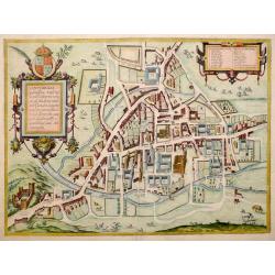
Cantebrigia, Opulentissimi Angliae Regni . . .
A sought after and highly decorative early bird's-eye plan of the ancient university town of Cambridge.The plan originally appeared in Braun & Hogenberg's Civitates O...
Date: Amsterdam, 1657
Selling price: ????
Please login to see price!
Sold in 2013
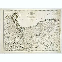
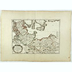
Duché de Pomeranie Contenant les Duchés de Stettin, de Wolgats, de Bardt, de Cassubie, de Vandalie, la Principauté et Isle de Rugen, le Comté de Gutzkow les Seigneuries de Louwenbroch et de Butow. . .
Fine map of Pomerania, now split between Germany and Poland, showing from Rostock east to Gdansk by George-Louis le Rouge.
Date: Paris, 1657
Selling price: ????
Please login to see price!
Sold in 2015
Nordoviaim.....
The English city of Norwich in the county of Norfolk is shown here from the north-west. The cathedral church "called Christes" is immediately identifiable withi...
Date: Amsterdam, 1657
Selling price: ????
Please login to see price!
Sold in 2014
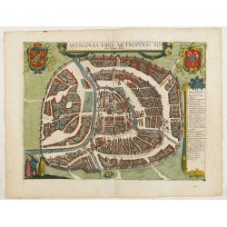
Moscovia urbs Metropolis totius Russiae Albae.
Detailed bird's-eye town-plan of Moscow from Jansson's rare town book. With a key (1-20) to important spots in town. The verso has French text and originates from Jansson...
Date: Amsterdam, 1657
Selling price: ????
Please login to see price!
Sold
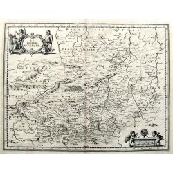
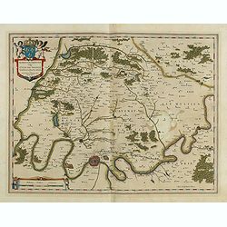
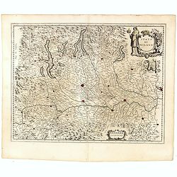
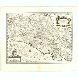
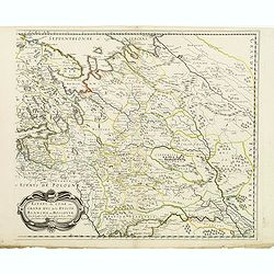
Le Duche de Auvergne.
A quaint map of the Auvergne, printed in Frankfurt by Caspar Merian in 1657. With a decorative title cartouche featuring three peasants from the region. A striking scale ...
Date: Frankfurt, 1657
Selling price: ????
Please login to see price!
Sold in 2016
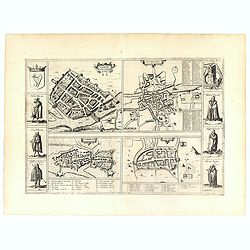
Galwaye, Dubline , Lymericke, and Corcke.
Four early town plans with six costume vignettes, the Irish crest and a view of Enniskillen Castle down the sides, published in the 'Civitates Orbis Terrarum'. All the il...
Date: Amsterdam, 1657
Selling price: ????
Please login to see price!
Sold in 2019
Tabula nova Poloniae et Silesiae.
Seventh state, with new title and changes in borders. Since a crack was already visible in the view of Gdansk on the 1657 state, Pieter Hendricksz Schut had to etch a new...
Date: Amsterdam, 1630 but after 1657
Selling price: ????
Please login to see price!
Sold in 2016
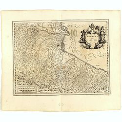
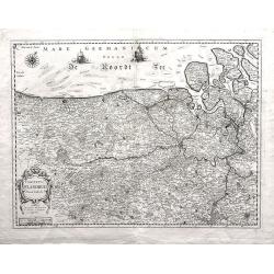
Basse partie de la Basse Saxe.. Duches de Sleswick, Holsace, Meckelenbourg..
Detailed map of the northeastern part of Germany. Nicolas Sanson was to bring about the rise of French cartography, although the fierce competition of the Dutch would las...
Date: Paris, 1657
Selling price: ????
Please login to see price!
Sold in 2017
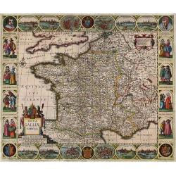
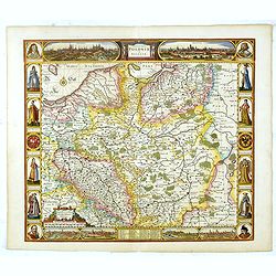
Nova Galliae Tabula.
A rare carte à figures of France by Cloppenburg.
Date: Amsterdam, 1657
Selling price: ????
Please login to see price!
Sold in 2017
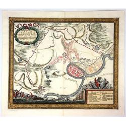
Ichnogeraphia Oppidi Itzehoae.
Itzehoe Germany town plan with course of the Stoer River. The map is copperplate engraved with hand coloring and shows the hinterland of Itzehoe during the Swedish Thirt...
Date: Stockholm , 1657
Selling price: ????
Please login to see price!
Sold in 2017
Le Duche de Auvergne.
A fine 17th century copper engraved map after Jansson, published in Martin Zeiller's Topographia Galliae. Very detailed, filled with towns, areas, rivers, woods, etc. Wit...
Date: Frankfurt, c1657
Selling price: ????
Please login to see price!
Sold in 2019
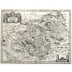
Bituricum Ducatus / Duche de Berri.
A fine copper engraved map published in Martin Zeiller's Topographia Galliae. Very detailed, filled with towns, areas, rivers, woods, etc.
Date: Frankfurt, ca. 1657
Selling price: ????
Please login to see price!
Sold in 2019
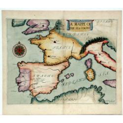
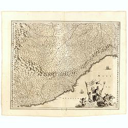
A Mappe of The Sea Coasts. (South-west Europe)
A unusual map showing the Atlantic coasts of Europe and part of the Western Mediterranean, with the northern tip of North Africa. Ungraduated chart. Text in English and L...
Date: England, ca. 1657
Selling price: ????
Please login to see price!
Sold in 2020
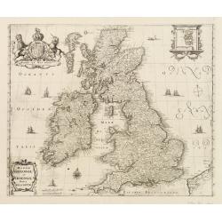
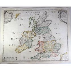
Magnae Britanniae et Hiberniae nova descriptio.
Map shows England, Scotland and Ireland, Shetland islands on separate insert in upper right corner. Belgium coastal area in right bottom. Large uncolored cartouche on top...
Date: Frankfurt, c.1658
Selling price: ????
Please login to see price!
Sold in 2017
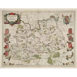
Surria Vernacle Surrey.
Highly decorative showing the seven coats of arms of the Surrey Earls all in full color. Shows towns of London and Kingston on the Thames River, Guildford, Croydon, Richm...
Date: Amsterdam, 1658
Selling price: ????
Please login to see price!
Sold in 2009
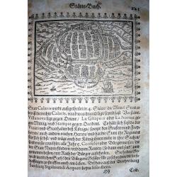
Calaris
Very rare woodcut birds-eye view of Cagliari, the capital of Sardinia. Showing numerous buildings and ships! From Saur's important work "Stätte-Buch... / Beschreib...
Date: Frankfurt, 1658
Selling price: ????
Please login to see price!
Sold in 2009
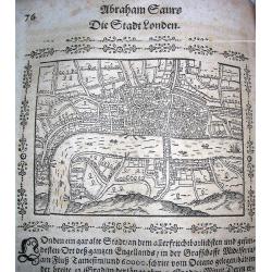
London.
Very rare woodcut birds-eye view of London during the early 17th century. Shows numerous buildings and ships! From Saur's important work "Stätte-Buch.....
Date: Frankfurt, 1658
Selling price: ????
Please login to see price!
Sold in 2009
Die Stadt Rom.
Very rare woodcut birds-eye view of Rome during the early 17th century. Shows numerous buildings and streets! On page within text, text also to verso. From Saur's importa...
Date: Frankfurt, 1658
Selling price: ????
Please login to see price!
Sold in 2010
Die Statt Genua.
Very rare German woodcut birds-eye view of Genoa from the early 17th century. Shows the city and the harbour from the sea-side with sailing-ships! On page within decorati...
Date: Frankfurt, 1658
Selling price: ????
Please login to see price!
Sold in 2010
Antorff
Very rare German woodcut birds-eye view of Antwerp during the early 17th century. Shows the city with its buildings and fortifications, and the Scheldt river with ships! ...
Date: Frankfurt, 1658
Selling price: ????
Please login to see price!
Sold in 2010
Carte Geograhicque des Postes qui traversent la France. . .
The earliest post road mapspost route map was first published 1632 by Melchior Tavernier - this "Carte Géographique des Postes qui traversent France" shows all...
Date: Paris, 1632-1658
Selling price: ????
Please login to see price!
Sold in 2011
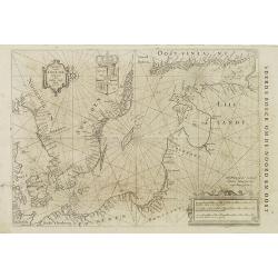
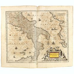
Pascaart vande Oost-Zee beschreven door Willem Ians Blauw ao. 1622.
Very rare chart of the Baltic Sea and the Gulf of Finland. Published in De groote Zee-spiegel. inhoudende een korte Onderswij singe in de konst der zeevaert en eene besch...
Date: Amsterdam, Joan Blaeu, 1655-1658
Selling price: ????
Please login to see price!
Sold in 2010
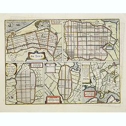
De Zype./ Purmer/ Wormer/ Beemster/ Waterland.
Five maps on one sheet. Showing the polders of De Zype, De Purmer, De Wormer, De Beemster and a map of Waterland, including de Bylmermeer and Monnekedam. Showing the Noor...
Date: Amsterdam, 1652-1658
Selling price: ????
Please login to see price!
Sold in 2011
Nova descriptio totius regni Polonici nec non Magni Ducatus Lithuaniae cum suis Palatinatibus Castellaniis ac Confiniis.
Very rare map of Poland in the shape of an eagle, toped with a crown "Aquila Polonica". The map appeared in the rare work by August Gudicanus "Borussi-Polo...
Date: Cologne, J. A. Kinckium, 1658
Selling price: ????
Please login to see price!
Sold in 2011
Ager Parisiensis Vulgo L'Isle de France. . .
A very decorative map showing the environs north of Paris with beautiful cartouches.
Date: Amsterdam, 1658
Selling price: ????
Please login to see price!
Sold in 2016
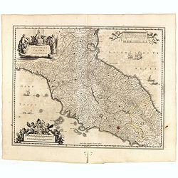
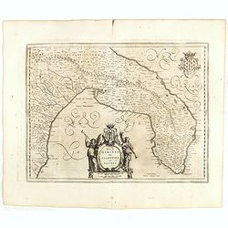
Stato della CHIESA con la Toscana.
Decorative and attractive map of the region from the rare last edition of Janssonius Atlas. Includes sailing ships, sea monster and other decorative embellishments.
Date: Amsterdam, 1645-1658
Selling price: ????
Please login to see price!
Sold in 2015
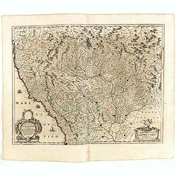
Stato di Milano.
A most attractive and fascinating map of northern Italy with Milan in center, including Lago Maggiore, Parma, Turin, and Como.
Date: Amsterdam, 1645-1658
Selling price: ????
Please login to see price!
Sold in 2015
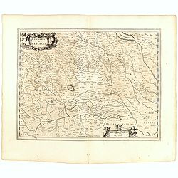
Signoria di Vercelli.
Decorative map centered on Vercelli, including also Novara, etc.
Date: Amsterdam, 1645-1658
Selling price: ????
Please login to see price!
Sold in 2015
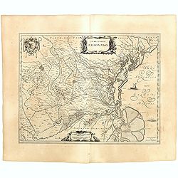
Territorio Podovano.
Map of the Territory of Padua in Northern Italy’s Veneto region. It’s known for the frescoes by Giotto in its Scrovegni Chapel and the vast 13th-century Basilica of S...
Date: Amsterdam, 1645-1658
Selling price: ????
Please login to see price!
Sold in 2015
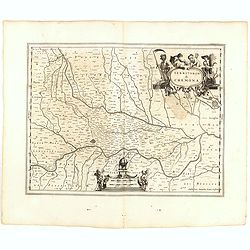
Territorio di Cremona.
Decorative map centered on Cremona and Mantua in the utmost right hand corner.
Date: Amsterdam, 1645-1658
Selling price: ????
Please login to see price!
Sold in 2015
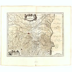
Ducato di Ferrara.
Nice example of Janssonius' map of the Ferrara region, including the towns of Ferrara and Bologna. Includes a decorative cartouche.
Date: Amsterdam, 1645-1658
Selling price: ????
Please login to see price!
Sold in 2015
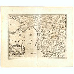
Principato Citra olim Picentia.
Nice example of Janssonius' map of the Mediterranean Coast of Southern Italy, including the Island of Capri and the Gulf of Salerno and the Gulf of Policastro.
Date: Amsterdam, 1645-1658
Selling price: ????
Please login to see price!
Sold in 2015
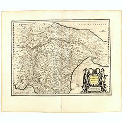
Capitanata olim mesapiae ey iapygiae pars.
Great detail of villages throughout the area, mountains in relief, river systems.
Date: Amsterdam, 1645-1658
Selling price: ????
Please login to see price!
Sold in 2015
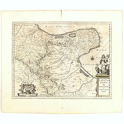
Terra Di Bari et Basilicata .
Janssonius map of the Territory of Bari in Southern Italy. Includes sailing ships, sea monsters and decorative cartouche.
Date: Amsterdam, 1645-1658
Selling price: ????
Please login to see price!
Sold in 2015
Territorio Di Orvieto.
Nice example of Janssonius' map of the Territory of Orvieto in Southern Italy.
Date: Amsterdam, 1645-1658
Selling price: ????
Please login to see price!
Sold in 2015
Contado Di Molise et Principato Ultra.
Decorative regional map of Italy, engraved by Jansson.
Date: Amsterdam, 1645-1658
Selling price: ????
Please login to see price!
Sold in 2015
CAMPAGNA DI ROMA olim Latium: Patrimonio Di Pietro et Sabina.
Fine map of the region around Rome that extends from Lago di Bolsena to Gaeta. Rome is depicted in a block plan with its fortifications evident.
Date: Amsterdam, 1645-1658
Selling price: ????
Please login to see price!
Sold in 2015
Riviera di Genova Di Ponente.
Nice example of Janssonius' maps of the Italian Riviera, from Nice to Genoa, extending north to Turin. Includes a decorative cartouche and sailing ships.
Date: Amsterdam, 1645-1658
Selling price: ????
Please login to see price!
Sold in 2015
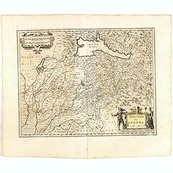
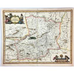
Territorio di VERONA.
The Province of Verona, centered on the city but also showing Mantua and Lake Garda.
Date: Amsterdam, 1645-1658
Selling price: ????
Please login to see price!
Sold in 2015
Territorio Trevigiano.
Detailed map of the Gulf of Venice and the area north west of Venice, with Mestre, Padua, Treviso, etc.
Date: Amsterdam, 1645-1658
Selling price: ????
Please login to see price!
Sold in 2015
Parte Alpestre dello Stato di Milano con il Lago Maggiore di Lugano, é di Como.
Detailed map of Milano, with the lakes of Lugano, Maggiore and Como.
Date: Amsterdam, 1645-1658
Selling price: ????
Please login to see price!
Sold in 2015
Neapolitanum Regnum.
Engraved map of the Kingdom of Naples, the 'boot' or southern portion of Italy.
Date: Amsterdam, 1645-1658
Selling price: ????
Please login to see price!
Sold in 2015
Romagna olim Flaminia..
Very fine map centered on the town of Ravenna.
Date: Amsterdam, 1645-1658
Selling price: ????
Please login to see price!
Sold in 2015
Ducato di Modena Regio et Carpi col Dominio della Carfagnana.
Nice example of Janssonius' map of the Emilia Romagna region including Parma, Reggio, Modena, Bologna.
Date: Amsterdam, 1645-1658
Selling price: ????
Please login to see price!
Sold in 2015
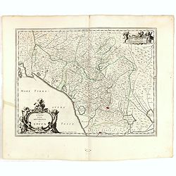
Stato della Republica di Lucca.
Including the area north of the towns of Pisa and Lucca. Two very decorative cartouches.
Date: Amsterdam, 1645-1658
Selling price: ????
Please login to see price!
Sold in 2015
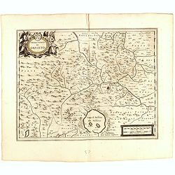
Terra di Otranto olim Salentina et Iapigia.
Map of the Salento Peninsula, Italy.
Date: Amsterdam, 1645-1658
Selling price: ????
Please login to see price!
Sold in 2015
Principatus Pedemontii, Ducatus Augustae Praetoriae, Salutii Marchionatus, Astae, Vercellarum et Niceae Comitatus Nova Tabula
This is a detailed map of the Piedmont region centered on Turin. The Mediterranean coastline is illustrated from Nice to Genoa and the many fortified cities are well docu...
Date: Amsterdam, 1645-1658
Selling price: ????
Please login to see price!
Sold in 2015
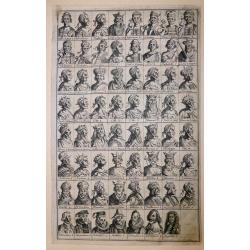
‘Icons of Roman Emperors and Kings of Hungary'
An unusual engraving, comprised of 63 portraits of Roman Emperors and Kings of Hungary. Latin text.From ‘Icons of Roman Emperors and Kings of Hungary’ by Paul Fürst ...
Date: Nuremberg, 1658
Selling price: ????
Please login to see price!
Sold in 2018
Monmedi en Luxemberg.
A very fine copper engraving featuring the Citadel of Montmedy. In 1221, the first castle of Montmédy was built on top of a hill by the Count of Chiny. Montmédy soon be...
Date: Paris, 1658
Selling price: ????
Please login to see price!
Sold in 2018
Imperii Caroli Magni..
Prepared by Petrus Bertius in 1616. Very large historical wall map (4 sheets joined) depicting the empire of Charles the Great.Fully engraved with mountains, forests, and...
Date: Amsterdam, 1658
Selling price: ????
Please login to see price!
Sold in 2023
Carte Generale Des Royaume d'Angleterre, Ecosse et Irelande.
A fine example of Sanson's first map of the British Isles. The distortion of lreland and the condensed size of Scotland was caused by the projection used by Sanson. This ...
Date: Paris, 1658
Selling price: ????
Please login to see price!
Sold in 2018
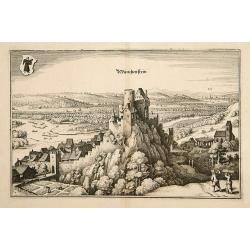
Munchenstein.
A bird's-eye view of Munichstein, with in the background the town of Basle. From Merian's Theatrum Europaeum.
Date: Frankfurt 1659
Selling price: ????
Please login to see price!
Sold
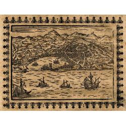
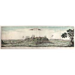
![[Untitled] Malta.](/uploads/cache/23373-250x250.jpg)
[Untitled] Malta.
RARE. Bird's eye-view of Malta showing an escutcheon with the Maltese Cross in the upper left corner. With vessels and galleys approaching the harbor.
Date: Padua, 1658 - 1659
Selling price: ????
Please login to see price!
Sold in 2014
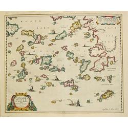
Cyclades Insulae In Mari Aegaeo, hodie Archipelago.
Johan Blaeu succeeded his father Willem when the latter died in 1638. Johan led the Blaeu firm to its greatest achievement, the ' Atlas Maior' in 12 parts, the greatest a...
Date: Amsterdam, 1659
Selling price: ????
Please login to see price!
Sold

Burgos.
A bird's-eye view of Burgos from Merian's "Theatrum Europaeum".
Date: Frankfurt, 1659
Selling price: ????
Please login to see price!
Sold in 2008
![[No tile - Bavaria]](/uploads/cache/26977-250x250.jpg)
[No tile - Bavaria]
Charming little map of part of Souther Germany, including de river Danube, made by Gabriel Bucelin (1599-1681). Bucelin was a Swiss genealogist and an author of several b...
Date: Ulm, Johannes Görlin, 1659
Selling price: ????
Please login to see price!
Sold in 2011
Le Cours de la Riviere de Wolga Anciennement appellee RHA Dedie A Monsieur Vion . . . 1659.
Olearius' more than one meter map of the Volga River, from the 1659 edition of Olearius' Relation du voyage d'Oléarius Adam en Moscovie, Tartarie, et Perse avec celui de...
Date: Paris, 1659
Selling price: ????
Please login to see price!
Sold in 2010
Comitatus Flandria Noua Tabula.
Finely detailed map of Flanders by Sanson published by Pierre Mariette. Shows the Flemish coastal region from Calais and Dunkirk, France to Antwerp, Belgium and includes...
Date: Paris, 1654-1659
Selling price: ????
Please login to see price!
Sold in 2010
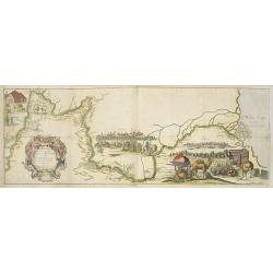
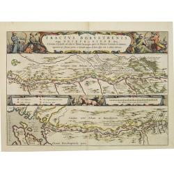
Tractus Borysthenis vulgo Dniepr et Niepr Dicti, à Bovzin . . .
This superb map shows the upper part of the Dnieper River in two horizontal strips, the upper map with a compass rose orienting the map, west to the top. It is richly emb...
Date: Amsterdam, 1659
Selling price: ????
Please login to see price!
Sold
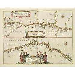
Tractus Borysthenis vulgo Dniepr et Niepr Dicti, A Civitate Czyrkassii as ostia et Ilmien lacum, per quem in Pontum Euxinium se exonerat . . .
This superb map shows the upper part of the Dnieper River in two horizontal strips, the upper map with a compass rose orienting the map, west to the top. It is richly emb...
Date: Amsterdam, ca. 1659
Selling price: ????
Please login to see price!
Sold
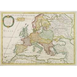
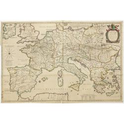
L'Europe
Fine map of Europe, with address of Pierre Mariette: rue st.Jacques a L'Esperance .Nicolas Sanson was to bring about the rise of French cartography, although the fierce c...
Date: Paris, 1650-1659
Selling price: ????
Please login to see price!
Sold in 2011
Etats du Czar ou Grand Duc de la RUSSIE.
Map of the European part of Russia by one of the most important French mapmaker. Engraved by A. Peyrouin.
Date: Paris, 1650-1659
Selling price: ????
Please login to see price!
Sold in 2012
Civitatis Imp. Lindaviensis Territorium.
Hand-colored copper engraved map of Lindau (Bodensee), Germany. Two beautiful strapwork cartouches with scale cartouche with two putti holding it. Also two pillars dat3ed...
Date: Amsterdam, 1659
Selling price: ????
Please login to see price!
Sold in 2017