Browse Listings in Europe
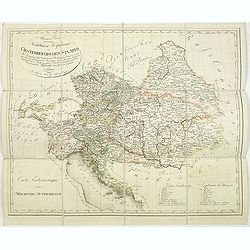
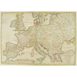
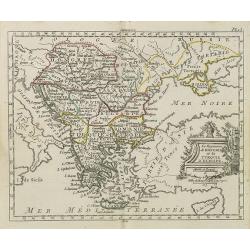
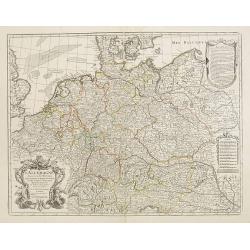
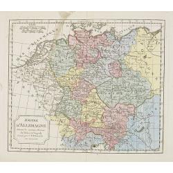
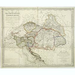
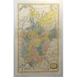
Allgemeine Charte zur Uebersicht der Kirchlichen Verfassung des oesterreichischen Staates = Carte eccle´siastique de la monarchie autrichienne : mit Bemerkung aller Erzbisthu¨mer. . .
Detailled map showing Central Europe and showing the Austria-Hungarian Monarchy. The map includes Austria, with parts of Poland, Germany, Italy, prepared by Karl Joseph K...
Date: Vienna, Kunst und Industrie Comptoirs,1804
Selling price: ????
Please login to see price!
Sold in 2013
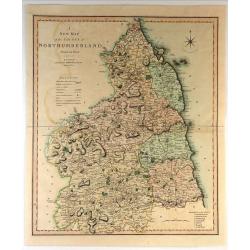
A New Map of the County of Northumberland Divided into Wards.
Handsome and detailed county map shows market towns with distances from London in measured miles. The major canals, roads, railways, parks and churches are also clearly m...
Date: London, 1804
Selling price: ????
Please login to see price!
Sold in 2018
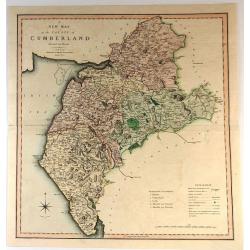
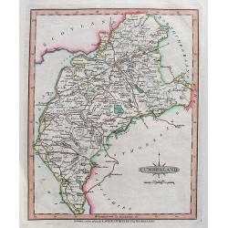
A New Map of the County of Cumberland
Handsome and detailed county map shows market towns with distances from London in measured miles. The major canals, roads, railways, parks and churches are also clearly m...
Date: London, 1804
Selling price: ????
Please login to see price!
Sold in 2017
A Map of the Dutchy of Holstein with the Territories of the Imperial Towns Hamburg and Lübek, Also the Bishoprick of Eutin...
A Map of the Dutchy of Holstein with the Territories of the Imperial Towns Hamburg and Lübek also the Bishoprick of Eutin…A pleasing map of the Duchy of Holstein, with...
Date: London, 1804
Selling price: ????
Please login to see price!
Sold in 2016
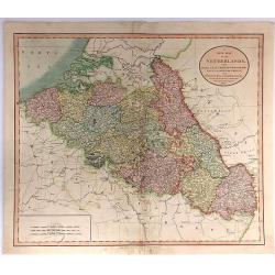
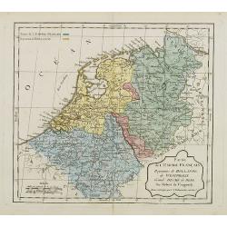
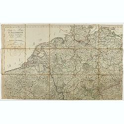
A New Map of the Netherlands, Also Of that part of Germany Westward of the Rhine
A detailed map of John Cary’s Netherlands, from the important early 19th century “NEW UNIVERSAL ATLAS”. It covers from Dunkirk eastward as far as the German border....
Date: London, 1804
Selling price: ????
Please login to see price!
Sold in 2017
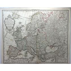
Carte D'Europe Dressee pour L'Instruction. . .
A striking example of Dezauche's revised edition of Delisle's map of Europe. With a new decorative cartouche, which was replaced after the French Revolution to remove th...
Date: Paris, 1804
Selling price: ????
Please login to see price!
Sold in 2018
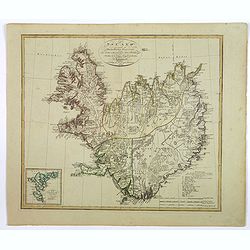
Island nach Murdochisher Projection. . .
An unusual, odd looking map of Iceland, based on Patrick Murdoch's projection of the previous century. As a result the island of Iceland looks 'shortened' or 'compacted'....
Date: Weimar, 1804
Selling price: ????
Please login to see price!
Sold in 2018

Edinburg.
An interesting city view of Edinburg, Scotland with a group of three prints below in German that translate to "Unexpected arrest of the chemist's famous Franz Genera...
Date: Unknown, 1804
Selling price: ????
Please login to see price!
Sold in 2019
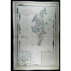
Carte des iles Shetland, d'après le plan du Cap. Anglais Preston, rectifié par M. de Lowenorn en 1787, Dépôt de La Marine, l'an XIII
Rare and very large and detailed nautical chart of the Shetland Islands, published in 1804 (year 13 of the French Revolution) by the French Ministry of the Navy, after th...
Date: Paris, 1787 / 1804
Selling price: ????
Please login to see price!
Sold in 2023
Charte Itineraire de l'Europe pour le guide des Voyageurs..
Uncommon road map of Europe. Prepared for the travel guide of Reichard, prepared by Güssefeld. Engraved by Frentzel.
Date: Weimar 1805
Selling price: ????
Please login to see price!
Sold
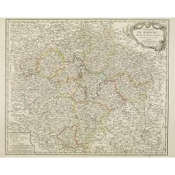
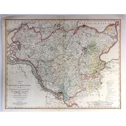
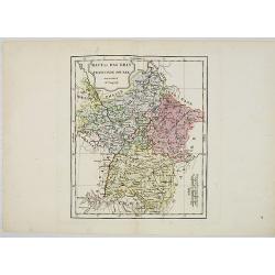
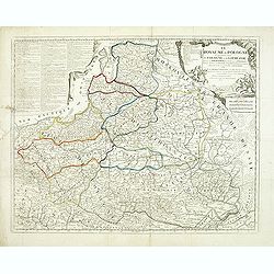
Royaume de Boheme divise en douze cercles. . .
Uncommon general map of the Czech Republic, centered on Prague. Prepared after a map of Johann Christoph Müller (1673-1721), who was a Austrian cartographer.Uncommon lat...
Date: Paris, dated 1805
Selling price: ????
Please login to see price!
Sold in 2014
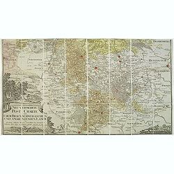
Neu vermehrte post charte der chur Braunschweigischen und angrenzenden lande. . . Von Friedrich Wilhelm Ohsen, ... privatim entworfen im Jahre 1774, verbessert 1805.
Unfortunately only the lower half of a post road maps map of North-Western Germany, centered on Braunsschweig.Prepared by Friederich Wilhelm Ohsen in 1774 and updated for...
Date: Hannover, 1774 - 1805
Selling price: ????
Please login to see price!
Sold in 2018
Das Kurfüstenthum Salzburg. . .
Map of Salzburg in Austria. Many annotation in black lead-pencil. More about folding maps. [+]
Date: Nurmberg, 1805
Selling price: ????
Please login to see price!
Sold in 2013
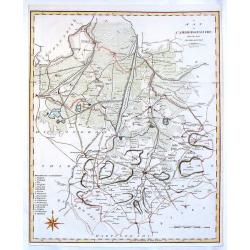
Cambridgeshire from the Best Authorities.
Detailed map of Cambridgeshire published by John Stockdale in Piccadilly. Nice presentation of roads mountains and rivers. It features the cities of Cambridge, Caxton, El...
Date: London, 1805
Selling price: ????
Please login to see price!
Sold in 2016

Umriss des Schwarzen Meeres des Bosphorus, des Propontes, des Hellesponts, des Archipelagus nebst den Küsten / nach den neuesten Bericht von D.F. Sotzmann 1803
Scarce map of the Black Sea, with inset map of the Sea of Marmara and four views of the fortifications of the Dardanelles Strait (Turkey).Published in "Gallerie der ...
Date: Berlin, Oehmigke, 1805
Selling price: ????
Please login to see price!
Sold in 2013
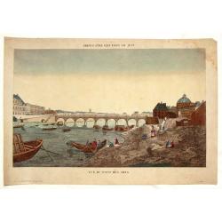
Vue du Pont des Arts.
Fine Vue Optique featuring the neighbourhood close to the Louvre. The bridge was the first iton bridge in Paris. Unlike most Vue Optique prints, the hand-coloring on this...
Date: Paris, 1805
Selling price: ????
Please login to see price!
Sold in 2019
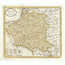
Poland from the best authorities.
Detailed map of Poland from "A New Geographical, Historical, and Commercial Grammar", by William Guthrie. William Guthrie (later engraver for Carey) London, UK....
Date: London, 1805
Selling price: ????
Please login to see price!
Sold in 2015
A MAP OF MIDDLESEX FROM THE BEST AUTHORITIES 1805
A detailed copper engraved map of the county of Middlesex by John Cary. The map was produced to accompany Richard Gough’s new edition of Camden’s Britannia and publis...
Date: London, 1805
Selling price: ????
Please login to see price!
Sold in 2017
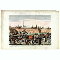
Entrée triomphale de la grande armée française commandée par Napoléon-le-Grand dans la ville de Vienne, capitale de l'Autriche le 13 novembre 1805.
Arrival of Napoleon in Vienna on 13 November 1805. With address "A Paris chez Basset M.d d'estampes et fabricant de papiers peints, Rue S.t-Jacques au coin de celle ...
Date: Paris, ca. 1805
Selling price: ????
Please login to see price!
Sold in 2016
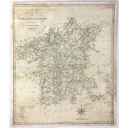
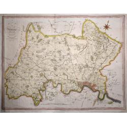
A Map of Worcester from the Best Authorities
A detailed and large map of Worcester, engraved by John Cary, for publication in Richard Gough's translation of William Camden's 'Britannia' in 1789. This edition was pu...
Date: London, 1805
Selling price: ????
Please login to see price!
Sold in 2017
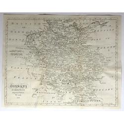
Germany Exhibiting the Present Seat of War, 1805.
A detailed map of Europe, highlighting the position of the war in and around Germany as at 1805. It covers and area from Denmark in the north Turkey in the south, from Fr...
Date: Germany, 1805
Selling price: ????
Please login to see price!
Sold in 2017
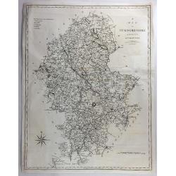
A Map of Staffordshire from the Best Authorities.
An attractive and detailed late 18th century map of Staffordshire, engraved by John Cary and published by Stockdale in Richard Gough's new translation of Camden's Britann...
Date: London, March 1805
Selling price: ????
Please login to see price!
Sold in 2018

Paysane du marquisat de Bade.
Originally hand-colored mezzotint from 'Costumes civils actuels de tous les peuples connus'. After Jacques Grasset de Saint-Sauveur. As an etcher, drawer and writer, Gras...
Date: Paris,1805
Selling price: ????
Please login to see price!
Sold in 2017
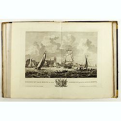
Atlas van de Zeehavens der Bataafsche Republiek, die van Batavia en Onrust. Mitsgaders der Afbeeldingen van de Haringvisscherij en de Walvischvangst..
Illustrated with a fine series of views of Dutch harbours, including two plates depicting Herring and Whale fishing scenes not included in the first edition of 1802.1. De...
Date: Amsterdam, E. Maaskamp, 1805
Selling price: ????
Please login to see price!
Sold in 2018
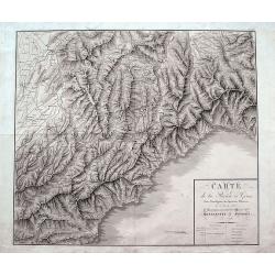
Carte de la Rivière de Gênes, Pour l'Intelligence des Opérations Militaires de 1792 à 1800...Montenotte et Mondovi en 1796.
A rare large scale map of Liguria and Piedmont from Alassio until Genoa. Extending until Fossano, Alba, Acqui Terme, and Novi Ligure in the north. The highly detailed map...
Date: France, ca. 1805
Selling price: ????
Please login to see price!
Sold in 2018
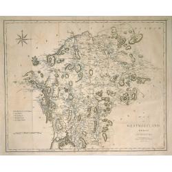
Map of Westmorland from the Best Authorities.
A finely engraved, highly detailed map by Cary, showing Ullswater, Windermere, etc. From Camden's 'Britannia' in 1789. John Cary (1754-1835) was an English cartographer, ...
Date: London, 1805
Selling price: ????
Please login to see price!
Sold in 2019

Entrée des Français à Berlin, le 27 Octobre 1806.
Engraving representing Napoleon and his troops in front of the Brandenburg Door.
Date: Paris, ca. 1806
Selling price: ????
Please login to see price!
Sold in 2008
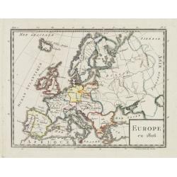
Europe en 1806.
Map of Europe, from Atlas de la Géographie de toutes les parties du monde .. Ouvrage destiné pour l\'education, et nécessaire aux négocians, aux voyageurs, aux foncti...
Date: Paris, Prudhomme, Levrault, Debray, 1806
Selling price: ????
Please login to see price!
Sold in 2009
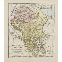
Hongrie, Turquie Europe..
Map of Hungary, southeast European countries in the Balkan peninsula, and Greece. By C. F. Delamarche, the successor of Robert de Vaugondy, Geographer.
Date: Paris, 1794 - 1806
Selling price: ????
Please login to see price!
Sold in 2008

Partie de l'empire français Royaume d'Italie, Toscane Etat du St. Siege Isle de Corse. . .
Map of Northern part of Italy with Corsica. By C. F. Delamarche, successor of Robert de Vaugondy, Geographer. With a color key showing the Italian and French possessions....
Date: Paris, 1806
Selling price: ????
Please login to see price!
Sold in 2008
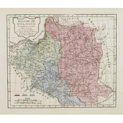
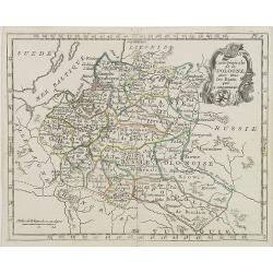
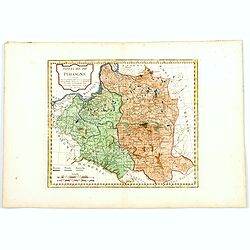
Royaume de Pologne.
Map of Poland and Lithuania. By C. F. Delamarche, successor of Robert de Vaugondy, Geographer.With a color key to Russian, Prussian and Austrian possessions.
Date: Paris, 1794 - 1806
Selling price: ????
Please login to see price!
Sold in 2008
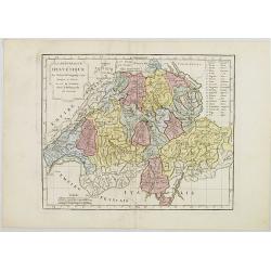
La République Helvétique en ses 19 Cantons.
Map of Switzerland. By C. F. Delamarche, successor of Robert de Vaugondy, Geographer.
Date: Paris, 1794 - 1806
Selling price: ????
Please login to see price!
Sold in 2019
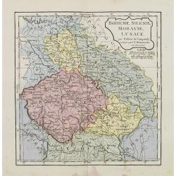
Bohême, Silésie, Moravie, Lusace.
Map of central Europe including Bohemia, Austria, Hungary, Silesia and Moravia. By C. F. Delamarche, successor of Robert de Vaugondy, Geographer.
Date: Paris, 1794 - 1806
Selling price: ????
Please login to see price!
Sold in 2015
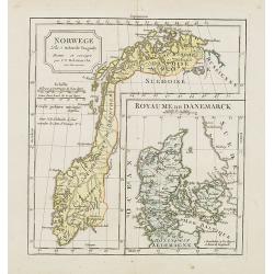
Norwege. . .
Map of Norway., with inset map of Denmark.By C. F. Delamarche, successor of Robert de Vaugondy, Geographer.
Date: Paris, 1794 - 1806
Selling price: ????
Please login to see price!
Sold in 2023
Partie de l'Empire Français, Royaume de Hollande, de Westphalie, Grand Duché de Berg.
Map of the Netherlands. By C. F. Delamarche, successor of Robert de Vaugondy, Geographer. With a color key to French and Dutch possessions.
Date: Paris, ca.1806
Selling price: ????
Please login to see price!
Sold in 2008
Haut et Bas Rhin Franconie Souabe.
Map of High and Low Rhine Franconie Souabe. By Robert de Vaugondy, Geographer.
Date: Paris, 1794 - 1806
Selling price: ????
Please login to see price!
Sold in 2022
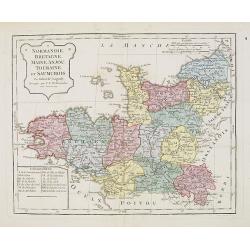
Normandie, Bretagne, Maine, Anjou, Tourraine, et Saumurois.
Map of Normandy, Brittany, Maine, Anjou, Tourraine, and the Saumur region. By C. F. Delamarche, successor of Robert de Vaugondy, Geographer. Inset lower left corner of t...
Date: Paris, 1794 - 1806
Selling price: ????
Please login to see price!
Sold in 2008
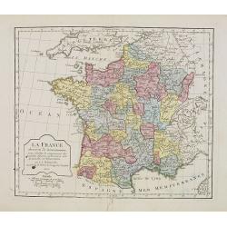
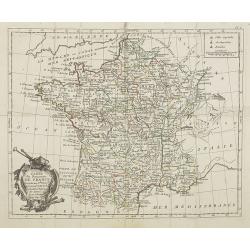
La France. . . .
Map of France. By C. F. Delamarche, successor of Robert de Vaugondy, Geographer.
Date: Paris, 1806
Selling price: ????
Please login to see price!
Sold in 2008
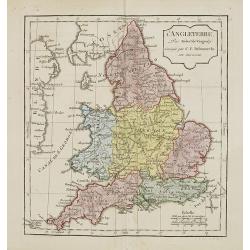
L'Angleterre.
Map of England. By C. F. Delamarche, successor of Robert de Vaugondy, Geographer.
Date: Paris, 1794 - 1806
Selling price: ????
Please login to see price!
Sold in 2011
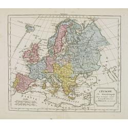
L'Europe. . .
Map of the European continent. By C. F. Delamarche, successor of Robert de Vaugondy, Geographer.
Date: Paris, 1794 - 1806
Selling price: ????
Please login to see price!
Sold in 2008
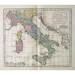
L' Italie.
Map of Italy. By C. F. Delamarche, successor of Robert de Vaugondy, Geographer.
Date: Paris, 1794 - 1806
Selling price: ????
Please login to see price!
Sold in 2018
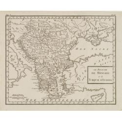
Le Royaume de Hongrie et la Turquie d' Europe . . .
Map of the Hungary, the Balkan States and present-day Greece, from Atlas moderne portatif composé de vingt-huit cartes sur toutes les parties du globe terrestre .. A l'u...
Date: Paris, Prudhomme, Levrault, Debray, 1806
Selling price: ????
Please login to see price!
Sold in 2010
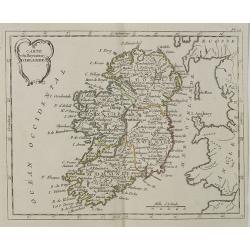
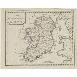
Carte du Royaume d' Irlande . . .
Map of Ireland, from Atlas moderne portatif composé de vingt-huit cartes sur toutes les parties du globe terrestre .. A l'usage des Colléges, des Pensions & des Mai...
Date: Paris, Prudhomme, Levrault, Debray, 1806
Selling price: ????
Please login to see price!
Sold in 2018
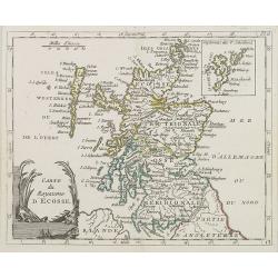
Carte du Royaume d' Ecosse . . .
Map of Scotland from Atlas moderne portatif composé de vingt-huit cartes sur toutes les parties du globe terrestre .. A l'usage des Colléges, des Pensions & des Mai...
Date: Paris, Prudhomme, Levrault, Debray, 1806
Selling price: ????
Please login to see price!
Sold in 2013
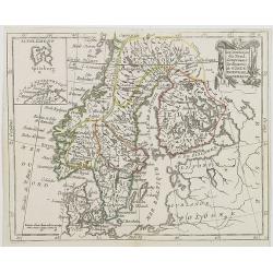
Les Couronnes du Nord, comprenant les royaumes de Suede, Norwege et Danemark.
Map of Sweden, Norway and Denmark, from Atlas moderne portatif composé de vingt-huit cartes sur toutes les parties du globe terrestre .. A l\'usage des Colléges, des Pe...
Date: Paris, Prudhomme, Levrault, Debray, 1806
Selling price: ????
Please login to see price!
Sold in 2009
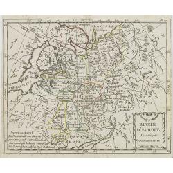
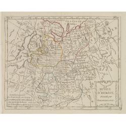
La Russie d\'Europe . . .
Map of western part of Russia, from Atlas moderne portatif composé de vingt-huit cartes sur toutes les parties du globe terrestre .. A l\'usage des Colléges, des Pensio...
Date: Paris, Prudhomme, Levrault, Debray, 1806
Selling price: ????
Please login to see price!
Sold in 2009
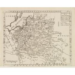
Carte Générale de la Pologne . . .
Map of Poland, from Atlas moderne portatif composé de vingt-huit cartes sur toutes les parties du globe terrestre .. A l'usage des Colléges, des Pensions & des Mais...
Date: Paris, Prudhomme, Levrault, Debray, 1806
Selling price: ????
Please login to see price!
Sold in 2016
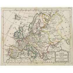
Carte de l' Europe . . .
General map of Europe from Atlas moderne portatif composé de vingt-huit cartes sur toutes les parties du globe terrestre .. A l'usage des Colléges, des Pensions & d...
Date: Paris, Prudhomme, Levrault, Debray, 1806
Selling price: ????
Please login to see price!
Sold in 2009
Carte du Royaume de France . . .
General map of France, from Atlas moderne portatif composé de vingt-huit cartes sur toutes les parties du globe terrestre .. A l'usage des Colléges, des Pensions & ...
Date: Paris, Prudhomme, Levrault, Debray, 1806
Selling price: ????
Please login to see price!
Sold in 2009
La Pologne Dressée sur ce qu'en ot donné Starovolsk, Beauplan, Hartnoch. . .
This is a late edition of the De L'Isle copper plate with a date of 1806. The copper plate was used many times and has several erased addresses.Large map of Poland, Lithu...
Date: Paris, 1806
Selling price: ????
Please login to see price!
Sold in 2010
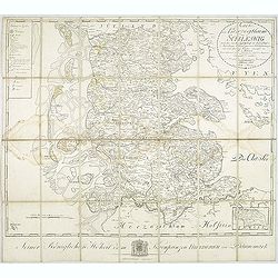
Karte vom Herzogthum Schleswig, nach der von der Gesellschaft der Wissenschaften in Kopenhagen bekannt gewordenen Ortsbestimmung und nach Special-Karten. Kolor. Kupferstichkarte von F. v. Golowin. Schleswig, Röhss u. Christiani, 1806.
Von Golowin was a Lieutenant in the "Schleswigschen Infanterie-Regiment" and appointed cartographer to the King. The first edition of this road map was publishe...
Date: Schleswig, Röhfs und Christiani, 1806
Selling price: ????
Please login to see price!
Sold in 2010
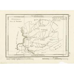
Département des 2 Nethes.
Map representing the area around Antwerp, with a short key list in the upper right corner.From Atlas de la Géographie de toutes les parties du monde .. Ouvrage destiné ...
Date: Paris, Prudhomme, Levrault, Debray, 1806
Selling price: ????
Please login to see price!
Sold in 2017
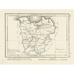
Département de l'Escaut.
Map centered on Gand, with a short key list in the lower left corner. From Atlas de la Géographie de toutes les parties du monde .. Ouvrage destiné pour l'education, et...
Date: Paris, Prudhomme, Levrault, Debray, 1806
Selling price: ????
Please login to see price!
Sold
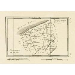
Département de la Lys.
Map representing the area between Furnes, Ypres, Courtray and Bruges, with a short key list in the upper right corner.From Atlas de la Géographie de toutes les parties d...
Date: Paris, Prudhomme, Levrault, Debray, 1806
Selling price: ????
Please login to see price!
Sold in 2023
Empire d'Allemagne. . .
Map of the German Empire. By C. F. Delamarche, successor of Robert de Vaugondy, Geographer.
Date: Paris, 1794 – 1806
Selling price: ????
Please login to see price!
Sold in 2022
Le ROYAUME de POLOGNE Comprenant les Etats de Pologne et de Lithuanie, divisez en Province et Subdivisez en Palatinats. . .
Extends from about Vienna in the west to east of the Crimea and north to include the present day Baltic States. It includes all of the present day Ukraine. The map was fi...
Date: Paris, ca. 1742 - 1806
Selling price: ????
Please login to see price!
Sold in 2012
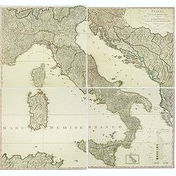
Italia Divisa ne' suoi Presenti Confini, disegnata da Ignazio Heymann Ufficiale nel Imp: & Ces: Reg: Supremo Uffizio delle Poste in Trieste. E divulgata a sue spese 1806.
Folding wall map showing Italy with Corsica, Sardinia and Sicily, Istria and the Dalmatian coast. Drawn, engraved and published by I. Heymann, Austrian geographer and dir...
Date: Trieste, Ignazo Heymann, 1806
Selling price: ????
Please login to see price!
Sold in 2016
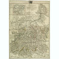
Die Oestreichische Erbmonarchie nach ihrem gegenwärtigen Zustande Kartenmaterial mit vorzüglicher Rücksicht auf ihre physische Beschaffenheit. . . / Carte générale de la monarchie autrichienn.
Detailed map showing Central Europe and showing the Austria-Hungarian Monarchy. The map includes Austria, with parts of Poland, Germany, Italy, prepared by Joseph Wüstin...
Date: Vienna, Kunst und Industrie Comptoirs,1806
Selling price: ????
Please login to see price!
Sold in 2013
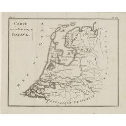
Carte de la République BATAVE.
Uncommon map of the Batavian Republic, published in the year of the Treaty on May 24th 1806 between France and the Batavian Republic.From Atlas de géographie du toutes p...
Date: Paris, Prudhomme, Levrault, Debray, 1806
Selling price: ????
Please login to see price!
Sold in 2020
La Russie d'Europe Divisée par Gouvernemens.
Map of European Russia, centered on Moscow. From Atlas de la Géographie de toutes les parties du monde .. Ouvrage destiné pour l'education, et nécessaire aux négocian...
Date: Paris, Prudhomme, Levrault, Debray, 1806
Selling price: ????
Please login to see price!
Sold in 2013
Les Couronnes du Nord, Comprenant les Royaumes de Suède, Norwege et Danemarck.
Map of Scandinavia, from Atlas de la Géographie de toutes les parties du monde .. Ouvrage destiné pour l'education, et nécessaire aux négocians, aux voyageurs, aux fo...
Date: Paris, Prudhomme, Levrault, Debray, 1806
Selling price: ????
Please login to see price!
Sold in 2018
Le Royaume de Hongrie et la Turquie d'Europe.
Map of south eastern Europe centered on Greece and the Aegean Sea. From Atlas de la Géographie de toutes les parties du monde .. Ouvrage destiné pour l'education, et n�...
Date: Paris, Prudhomme, Levrault, Debray, 1806
Selling price: ????
Please login to see price!
Sold in 2020
Dernier Partage de la Pologne Effectué en 1795, entre la Russie, la Prusse et l'Empire d'Allemagne.
Map of Poland, from Atlas de la Géographie de toutes les parties du monde .. Ouvrage destiné pour l'education, et nécessaire aux négocians, aux voyageurs, aux fonctio...
Date: Paris, Prudhomme, Levrault, Debray, 1806
Selling price: ????
Please login to see price!
Sold in 2014
Carte du Royaume Unis d'Irlande.
Map of Ireland, from Atlas de la Géographie de toutes les parties du monde.. Ouvrage destiné pour l'education, et nécessaire aux négocians, aux voyageurs, aux fonctio...
Date: Paris, Prudhomme, Levrault, Debray, 1806
Selling price: ????
Please login to see price!
Sold in 2014
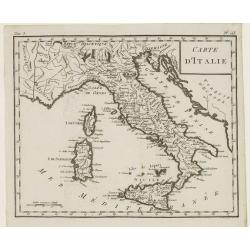
Carte d'Italie.
Map of Italy, including Sicily, Sardinia and Corsica. From Atlas de la Géographie de toutes les parties du monde.. Ouvrage destiné pour l'education, et nécessaire aux ...
Date: Paris, Prudhomme, Levrault, Debray, 1806
Selling price: ????
Please login to see price!
Sold in 2014
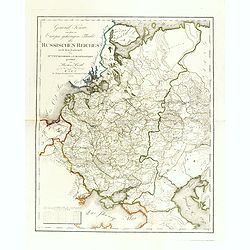
General Karte von dem zu Europa gehörigen Theile des Russischen Reiches nach dem Entwürfe des Hrn. J. M. Freyherrn von Lichtenstern. . .
Uncommon and detailed map of European Russia, with Lithuania, Latvia, Estonia, Balarus and Ukraine. According to the title design of H. Joseph Marx, Baron of Liechtenster...
Date: Vienna, Verlage des Kunst und Industrie Comptoir, 1806
Selling price: ????
Please login to see price!
Sold in 2014
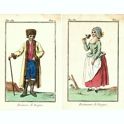
Bohémienne / Bohémien de Prague. (2 prints)
Two originally hand-colored mezzotints of citizens of Prague engraved by Félix Mixelle and Lachaussée Jeune after Jacques Grasset de Saint-Sauveur.As an etcher, drawer ...
Date: Paris,1801-1806
Selling price: ????
Please login to see price!
Sold in 2016
Royaume de Pologne.
Map of Poland and Lithuania. By C. F. Delamarche, successor of Robert de Vaugondy, Geographer.With a color key to Russian, Prussian and Austrian possessions.
Date: Paris, 1794 - 1806
Selling price: ????
Please login to see price!
Sold in 2016
Cumberland.
A detailed map of the area with many towns and villages named, connected by roads. Shows also hills, lakes, and rivers.Includes the "Picts Wall" near Carlisle.
Date: London, 1806
Selling price: ????
Please login to see price!
Sold in 2018
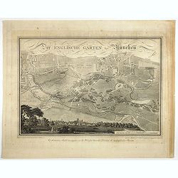
Der Englische Garten Bey München.
A northwest oriented plan of Der Englische Garten ( the English Garden) drawn by von Rickhauer in 1806 and engraved by J. Carl Schleich.The title in decorative lettering ...
Date: Topogr. Bureau, Munich 1806
Selling price: ????
Please login to see price!
Sold in 2017
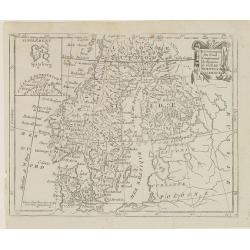
Cartes des Postes d'Allemagne et pays limitrophes. . .
Upper left part of a large detailed post road mapspost route map of Germany. Centered on Bielefeld and showing the cities of Hamburg, Coblenz. And Belgium, The Netherland...
Date: Trieste, 1806
Selling price: ????
Please login to see price!
Sold in 2018

Home & Femme de la Foret noire.
Originally hand-colored mezzotint from 'Costumes civils actuels de tous les peuples connus'. Engraved by Lachaussée Jeune after Jacques Grasset de Saint-Sauveur.As an et...
Date: Paris,1806
Selling price: ????
Please login to see price!
Sold in 2017

Dame d'Ausbourg.
Originally hand-colored mezzotint from 'Costumes civils actuels de tous les peuples connus'. After Jacques Grasset de Saint-Sauveur. As an etcher, drawer and writer, Gras...
Date: Paris,1806
Selling price: ????
Please login to see price!
Sold in 2023
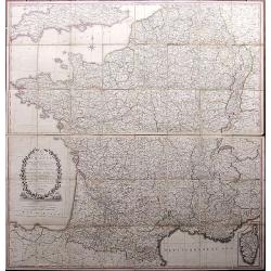
A Correct Map of France according to the New Divisions into Metropolitan Circles, Departments and Districts as decreed by the National Assembly, January 15th 1790 from a reduced copy of M. Cassini's large map...
A very large folding map of France with parts of England, the Benelux, Germany, Switzerland, Italy, and Spain. With an inset map of Corsica. Decorated with a large title ...
Date: London, 1806
Selling price: ????
Please login to see price!
Sold in 2017
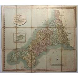
A New Map of Cornwall, Divided into Hundreds Exhibiting Roads, Rivers, Parks &c.
A superbly engraved map of the county of Cornwall by John Cary. From Cary's New English Atlas. The map was mounted on linen, folded and sold in a 7” x 4 ¾” x 3/8” ...
Date: London, 1806
Selling price: ????
Please login to see price!
Sold in 2018
Muscovy or Russia in Europe.
A fine map of western Russia by Brightly & Kinnersly of Suffolk in 1806. Interestingly, the land is called "Russian Lapland", and the Frozen Ocean. Engraved...
Date: Suffolk, 1806
Selling price: ????
Please login to see price!
Sold in 2018
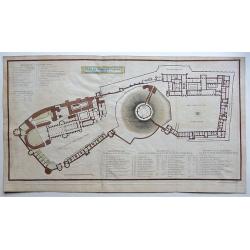
Plan of Windsor Castle MDCCCV.
A very detailed copperplate, plan and gazetteer of Windsor Castle, as it was at the time of The Battle of Trafalgar.Each tower, hall, chamber, ante-room and apartment's n...
Date: London, 1806
Selling price: ????
Please login to see price!
Sold in 2018
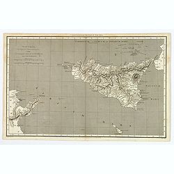
Sicilia, Provincia Romanorum cum Insulis Adjacentibus.
A functional and detailed map of the island of Sicily by Aaron Arrowsmith (1750-1823), an English cartographer, publisher and engraver, and a founding member of the Arrow...
Date: London, 1806
Selling price: ????
Please login to see price!
Sold in 2020
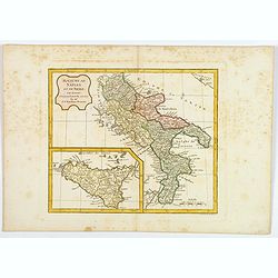
Royaume de Naples et de Sicile.
A map of the Kingdom of Naples, covering the southern part of Italy, with a smaller inset map of Sicily. By C. F. Delamarche, successor of Robert de Vaugondy, a French ge...
Date: Paris, 1794 - 1806
Selling price: ????
Please login to see price!
Sold in 2020
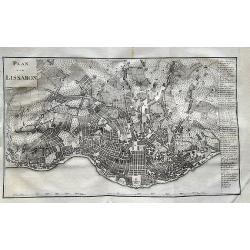
Plan von Lissabon.
Scarce city map of Lisbon. With 54 places named in the panel on the right. Published in Merkwürdigkeiten der Welt by Schrämbl.
Date: Vienna, 1806
Selling price: ????
Please login to see price!
Sold in 2019