Browse Listings in Europe
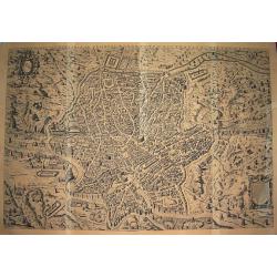
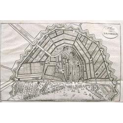
Urbis Romae sciographia ex antiquis monumentis accuratiss delineata.
Large scale & influential wall-map showing the city plan of Ancient Rome. The plate in 8 sheets was first engraved and published by Stephanus Du Perac in 1574, and th...
Date: Rome, ca. 1800
Selling price: ????
Please login to see price!
Sold in 2010
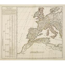
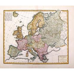
Imperii Occidentis Tabula synoptica.
Map of the Western part of the Empire of Julius Caesar. The map includes Western Europe, up to the east coast of Greece. With the western part of the Mediterranean with t...
Date: Paris, c.1800
Selling price: ????
Please login to see price!
Sold in 2013
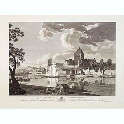
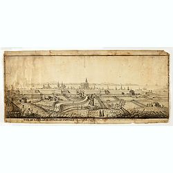
Het Valkhof of Vorstendoms-Burgt, eeven voor de slooping in 1795 getteekend.
Engraved by Ernst Karl Gottlieb Thelott after a model of Hendrik Hoogers. Beautiful view of "Het Valkhof at Nijmegen.
Date: Netherlands, ca. 1800
Selling price: ????
Please login to see price!
Sold in 2012
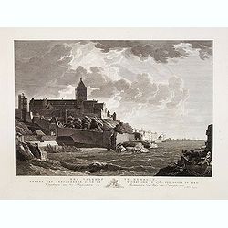
Het Valkhof te Nymegen, nevens het geruïneerde door de watervloed in 17874, ten ooste te zien.
Engraved by Ernst Karl Gottlieb Thelott after a model of Hendrik Hoogers. Beautiful view of "Het Valkhof at Nijmegen.
Date: Netherlands, ca. 1800
Selling price: ????
Please login to see price!
Sold in 2012
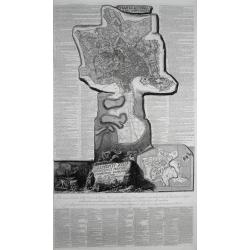
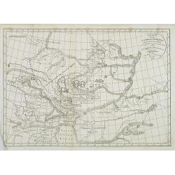
![[ Map of eastern Belarus, including Smolensk ] BL. 6.](/uploads/cache/30621-250x250.jpg)
[ Map of eastern Belarus, including Smolensk ] BL. 6.
Map of eastern part of Belarus. Map show the cities of Viciebsk, Orsha, Barysau, etc. including Smolensk in Russia. More about folding maps. [+]
Date: France, ca. 1800
Selling price: ????
Please login to see price!
Sold in 2013
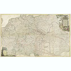
Deutschlands Postkarte begraenzt von Oesterreich, Preussen, Frankreich, Holland, Italien und der Schweiz. . .
Detailed and important post road mapspost route map prepared by Ignaz Heymann.
Date: Triest, 1800
Selling price: ????
Please login to see price!
Sold in 2013
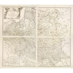
Generalkarte von Polen, Litauen, und den angraenzenden Laendern. . . (4 sheet map)
Large four sheet map of Poland, Lithuania, Vojvodina. Pages 85, 86, 87 and 88 from "Allgemeiner Grosser Schrämblischer Atlas" published by P. J. Schalbacher - ...
Date: Vienna, 1788-1800
Selling price: ????
Please login to see price!
Sold in 2013
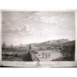
Veduta del Porto di Reggio Calabria.
View of the Italian port of Reggio Calabria engraved by Giovanni de Grado. Engraved from the painting by Hackert in the Reggia di Caserta, it belongs to the collection de...
Date: Naples, circa 1800
Selling price: ????
Please login to see price!
Sold in 2014
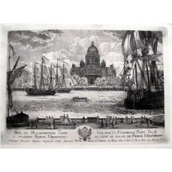
Vue sur la Catedrale Saint Isaak du coté du Palais de Prince Menchikoff.
A rare etching of the Cathedral (Saint Isaac's Cathedral or Isaakievskiy Sobor, Russian: Исаа́ки&...
Date: Saint Petersburg, after 1800
Selling price: ????
Please login to see price!
Sold in 2016
Vue de la Ville de citadelle capitale. Elle est dessinée du costé de terre ou costé de la porte pour aller à mahon.
Interesting and detailed water color of a panoramic view of the town of Mahon, seen from the land side.
Date: Mahon, ca. 1800
Selling price: ????
Please login to see price!
Sold in 2015
Pianta Di Roma E Del Campo Marzo.
Large sheet printed from 3 plates showing a city plan of modern (18th century) Rome within the Aurelian Walls, together with an extension showing the area between Porto d...
Date: Rome, ca. 1800
Selling price: ????
Please login to see price!
Sold in 2016
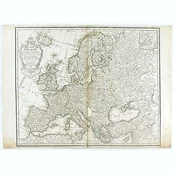
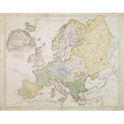
Carte de l'Europe Dressée pour l'Instruction . . .
The finely engraved map shows Europe divided up into its countries and the adjacenting regions Russia, the Middle East and North Africa. In the upper left corner we find ...
Date: Paris, 1800
Selling price: ????
Please login to see price!
Sold in 2020
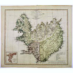
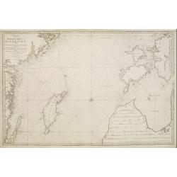
Island nach Murdochischer Projection...
An unusual map of Iceland by the German cartographer and geographer J.C.M. Reinecke, based on an earlier survey map by the Frenchman Verdun de la Crenne, done a generatio...
Date: Weimar, 1800
Selling price: ????
Please login to see price!
Sold in 2016
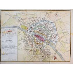
Paris sous le regne de Louis XIII.
Unusual plan which shows Paris as it was in the beginning of the 17th century. A very detailed map, with street names, parks, places, hospitals, and important buildings s...
Date: after 1800
Selling price: ????
Please login to see price!
Sold in 2016

Denkmal - Peter I Kaiser von Russland. In Petersburg.
Copper engraving of Peter the Great statue in Saint Petersburg. The Bronze Horseman is an equestrian statue of Peter the Great in Saint Petersburg, Russia. Commissioned b...
Date: Germany, ca. 1800
Selling price: ????
Please login to see price!
Sold in 2016
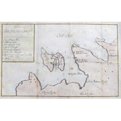
Der Baltische Hafen.
A curious map of the Pakri Islands in Estonia. With Suur-Pakri and Väike-Pakri and the near coast of Paldiski.A legend (a-h) names a sunken ship among other things! Furt...
Date: Unknown, ca. 1800
Selling price: ????
Please login to see price!
Sold in 2017
Plan de la Ville d'Anvers.
A beautiful antique hand colored map of Antwerp after the War of Spanish Succession (1701-1713), when Antwerp was transferred from Spanish control to the Austrian Habsbur...
Date: Paris, ca. 1800
Selling price: ????
Please login to see price!
Sold in 2018
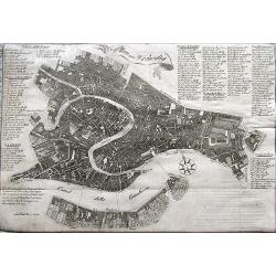
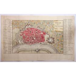
Plan von Venedig.
A scarce plan of Venice. With an extensive key naming more than 100 places on the map.
Date: Germany, ca. 1800
Selling price: ????
Please login to see price!
Sold in 2020
Plan von Amsterdam.
A small and attractive copper engraved plan of the city. Shows major buildings and the harbour filled with sailing ships.
Date: Germany, ca. 1800
Selling price: ????
Please login to see price!
Sold in 2017
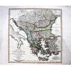
Charte vom Türkischen Reiche in Europa / nach den neuesten astronomischen Ortsbestimmungen entworfen. . .
A large, decorative map of central and south Europa showing the possessions of the Ottoman Empire in Europe in the year 1800.
Date: Weimar, 1800
Selling price: ????
Please login to see price!
Sold in 2019
![[Set of 4 plans] Ichonographia urbis antique Ravenne / Sunbridge Place, Bore Place and Sharps Place, the seats of John Hyde / Icon urbis Caesenae / Lilla in Flandra.](/uploads/cache/43026-250x250.jpg)
[Set of 4 plans] Ichonographia urbis antique Ravenne / Sunbridge Place, Bore Place and Sharps Place, the seats of John Hyde / Icon urbis Caesenae / Lilla in Flandra.
[Set of 4 European city plans] - Ichonographia urbis antique Ravenne (Ravenna in Italy) - Sunbridge Place, Bore Place and Sharps Place, the seats of John Hyde in England ...
Date: Amsterdam, Paris, ca 1783 - 1800
Selling price: ????
Please login to see price!
Sold in 2019
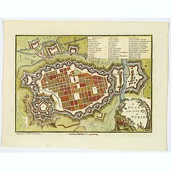
A Plan of the City of Turin.
An attractive small town plan of Turin, published in London at the beginning of the nineteenth century in John Stockdale's "Plans of the Principal Cities of the Worl...
Date: London, 1800
Selling price: ????
Please login to see price!
Sold in 2020
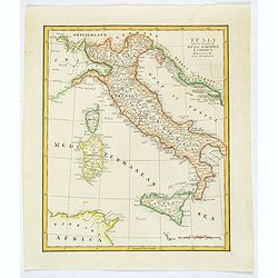
Italy with the Islands of Sicily, Sardinia & Corsica Drawn from the Best Authorities.
Antique copperplate map of Italy, and surrounding countries, together with the islands of Sicily, Sardinia & Corsica. Regions named. With a plain title and a mileage ...
Date: London, ca 1800
Selling price: ????
Please login to see price!
Sold in 2019
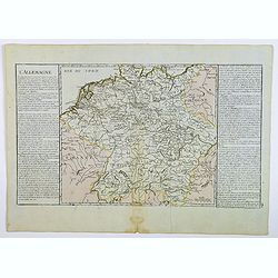
L'Allemagne.
A map of Germany of French origin, published in the late eighteenth or early nineteenth centuries, has informative and interesting text panels on either side. The map con...
Date: Paris, ca 1800
Selling price: ????
Please login to see price!
Sold in 2021
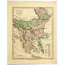
Turkey in Europe.
An attractive map, in beautiful original color, of Turkey in Europe, that part of the Ottoman Empire that lay west of Constantinople. It shows the countries that border t...
Date: London, 1800
Selling price: ????
Please login to see price!
Sold in 2020
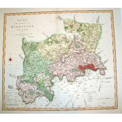
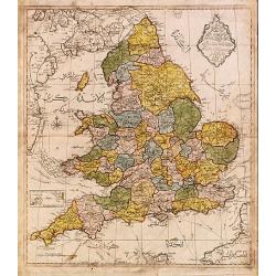
A New Map of the County of Middlesex.
A beautifully engraved and well-detailed turn of the 19th century map of County Middlesex, England. The metropolis of London and its environs are nicely highlighted, and ...
Date: London, dated 1801
Selling price: ????
Please login to see price!
Sold in 2008
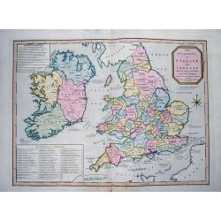
The invasions of England and Ireland with all their civil Wars since the Conquest.
Very interesting map showing the British Isles with their invasions and battles. Invasions (or attempts) are shown by small sailing ships, explained with text and the dat...
Date: London, 1801
Selling price: ????
Please login to see price!
Sold in 2012
Charta öfver Medlersta Delen af Östersjön..
Uncommon chart centred on the Baltic Sea, giving good detail of the south-eastern coast of Sweden with the Gotland island, part of the coast of Latvia and Estonia with th...
Date: Stockholm 1801
Selling price: ????
Please login to see price!
Sold
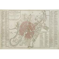
Plan géométral de la ville de Moscow ancienne capitale de l'empire de Russie. . .
Uncommon and detailed town-plan of the city of Moscow. To the left and right numbered keys to the most important spots in town. The lettered key stating the different Str...
Date: Paris, 1801
Selling price: ????
Please login to see price!
Sold in 2009
Neuest Post Karte von Deutschland und dessen angrenzenden Ländern. . .
A uncommon post road mapspost route map of Germany, Poland, Austria, Switzerland and the Low countries. Highly detailed map, showing post offices with the intermediate di...
Date: Berlin, 1801
Selling price: ????
Please login to see price!
Sold in 2013
![[Sheet one of "Carte Reduite De La Carte Generale D'Allemagne"]](/uploads/cache/26339-250x250.jpg)
[Sheet one of "Carte Reduite De La Carte Generale D'Allemagne"]
Top left sheet of a large folding nine-sheet map of Germany prepared by Jean Baptiste Hippolyte, baron Chauchard and published by Jean-Claude Dezauche (1745?-1824)Showing...
Date: Paris, 1801
Selling price: ????
Please login to see price!
Sold in 2013
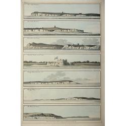
Five colored plates from the `Little Sea Torch'or, ‘True guide for coasting pilots:'
Published in Serres's scarce marine pilot, 'The Little Sea Torch', an acknowledged English edition of Bougard's 'Le Petit Flambeau de la Mer', although extensively revise...
Date: London, 1801
Selling price: ????
Please login to see price!
Sold in 2013
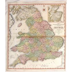
A Map of England, Wales & Scotland
With an inlay of a portion of Scotland, this map depicts all the direct and principal crossroads. There is an interesting compass rose. William Faden (1750 - 1836) was ...
Date: London, 1801
Selling price: ????
Please login to see price!
Sold in 2015
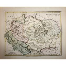
Pannonia, Dacia, Illyricum et Moesia.
A copper engraved map by John Roper, published in "Wilkinson's Atlas Classica" in 1801. The map covers the ancient Roman provinces of Pannonia, Dacia, Illyricum...
Date: London, 1801
Selling price: ????
Please login to see price!
Sold in 2016
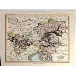
Austria By John Cary
A fine map of Austria and Slowenia. John Cary (1754 –1835) was an English cartographer. He served his apprenticeship as an engraver in London, before setting up his own...
Date: London, 1801
Selling price: ????
Please login to see price!
Sold in 2015
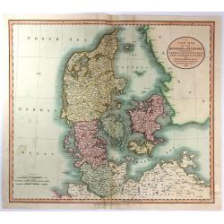
A New Map of the Kingdom of Denmark, Comprehending North and South Jutland, Zeeland, Fyen, Laaland, and Part of Holstein
A striking map of the region, colored by its provinces. It shows towns, roads, rivers, lakes, mountains, islands, etc. The map offers great detail and color coding accor...
Date: London, 1801
Selling price: ????
Please login to see price!
Sold in 2016
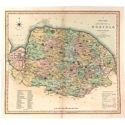
A New Map of the County of Norfolk Divided into Hundreds.
Large size, decorative map of the County of Norfolk by Jones, Smith & Co. for Smith's New English Atlas. The first map of the County to show longitudes measured from ...
Date: London, 1801
Selling price: ????
Please login to see price!
Sold in 2016
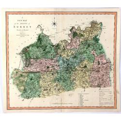
A New Map of the County of Surrey Divided Into Hundreds
A large sized, decorative map of the English County of Surrey by Jones, Smith & Co. for Smith's “New English Atlas”. This is the first map of the County to show l...
Date: London, 1801
Selling price: ????
Please login to see price!
Sold in 2016
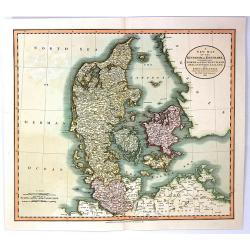
A New Map of the Kingdom of Denmark, Comprehending North and South Jutland, Zeeland, Fyen, Laaland, and Part of Holstein
An attractive, very detailed map of Denmark. Covers Jutland and the islands of Zeeland, Fyen, Laaland. Also includes most of the Duchy of Holstein and parts of Lower Saxo...
Date: London, 1801
Selling price: ????
Please login to see price!
Sold in 2016
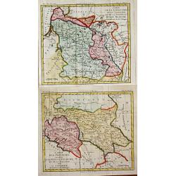
Carte de la Lithuanie, de la Courlande et de la Nouvelle Russie Blanche démembrée de la Pologne. / Carte des Province annexées a la Petite Pologne et de la Gallicie avec la Lodomerie démembrées de la Pologne.
Louis Brion de la Tour (1756-1823), French geographer. '' Atlas Géneral, Civil et Ecclésiastique'', 1766, '' Atlas Général'', 1790-98.Little map of Lithuania and Ukra...
Date: Paris, 1802
Selling price: ????
Please login to see price!
Sold in 2010
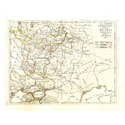
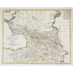
La parte meridionale della Russia Europea in Roma 1802
Scarce map of European part of Russia, with Crimea in lower left corner.
Date: Italy, ca. 1802
Selling price: ????
Please login to see price!
Sold in 2013
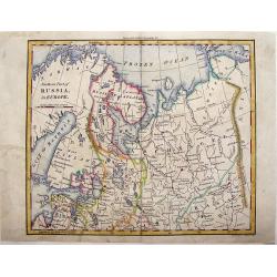
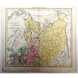
Northern Part of Russia in Europe.
Striking little map of the Northern part of Western Russia by William Darton. Published by Vernor & Hood in 1802 in London in "ATLAS TO WALKER'S GEOGRAPHY".
Date: London, 1802
Selling price: ????
Please login to see price!
Sold in 2018
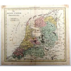
The Seven United Provinces.
Fine hand-colored map of The Netherlands engraved by William Darton from Walker's Geography in London in 1802. William Darton, Sr. started his map-making business in 178...
Date: London, 1802
Selling price: ????
Please login to see price!
Sold in 2018
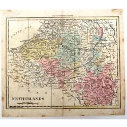
Netherlands.
Detailed map of the Netherlands by William Darton Jr. It is from Walker's Geography and is decorated with original coloring.
Date: London, 1802
Selling price: ????
Please login to see price!
Sold in 2016
Northern Part of Russia in Europe.
Detailed map of the "Northern Part of Russia in Europe" by William Darton Jr. It is from Walker's Geography and is decorated with original coloring.
Date: London, 1802
Selling price: ????
Please login to see price!
Sold in 2015
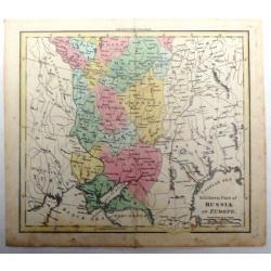
Southern Part of Russia in Europe.
Detailed map of the "Southern Part of Russia in Europe" by William Darton Jr. It is from Walker's Geography and is decorated with original coloring.
Date: London, 1802
Selling price: ????
Please login to see price!
Sold in 2015
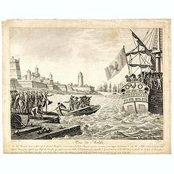
Prise de Malthe : le 24 prairial, an 6, 12 juin 1798. le général Bonaparte commandant la flotte française qui, par son ordre, avoit investi la capitale de cette isle et l'isle entière de tous les côtés, ...
Print belonging to a suite illustrating the General Napoleon Bonaparte’s campaigns.Read more about Napoléon Bonaparte [+]
Date: Paris, chez Jean, 1797 -1802
Selling price: ????
Please login to see price!
Sold in 2016
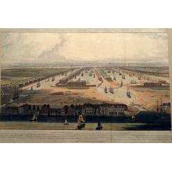
An Elevated View of the New Docks & Warehouses now constructing on the Isle of Dogs near Limehouse for the reception & accommodation of Shipping in the West India Trade,...
A fantastic bird's-eye view of the West India Docks, looking west towards the City of London. Very detailed with many sailing ships, buildings, and people on foot or hors...
Date: London, 1802
Selling price: ????
Please login to see price!
Sold in 2016
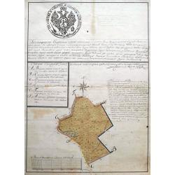
Subzow manuscript map.
An early manuscript map showing an area in or near Subzow in Tver Oblast, Russia. Subzow is located along the M9 highway from Moscow to Riga. This plan is possible a land...
Date: ca. 1802
Selling price: ????
Please login to see price!
Sold in 2018
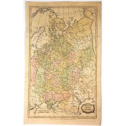
Muscovy or Russia in Europe.
Fine detailed engraved map of European Russia. It is from the "ENGLISH ENCYCLOPEDIA ...". The map is by George Kearsley and was engraved by Barlow. The Arctic o...
Date: London, 1802
Selling price: ????
Please login to see price!
Sold in 2017
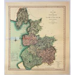
A New Map of the County Palatine of Lancaster Divided into Hundreds.
A large sized and decorative map of the county by Jones, Smith & Co. for Smith's "New English Atlas". The first map of the County to show longitudes measure...
Date: London, 1802
Selling price: ????
Please login to see price!
Sold in 2017
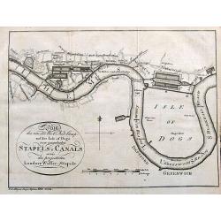
Plan des von der West Ind. Comp. auf der Isle of Dogs neu angelegten Staples u. Canals sowie des projectirten Londner Wasser-Stapels.
An unusual German plan of the proposed new docks in London: the West India Docks, St Katherine's & Greenland Dock. Also marked is Perry's Dock, at one time the bigges...
Date: Weimar, ca. 1802
Selling price: ????
Please login to see price!
Sold in 2017
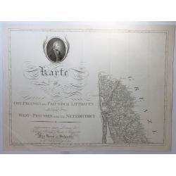
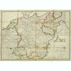
Karte von Ost-Preussen Nebst Presussisch Litthauen und West-Preussen Nebst dem Netzdistrict.
Title section of this important multi sheet map of Prussia, Lithuania and Poland, showing territories of present Lithuania. With a medailon representing the King of Pruss...
Date: Berlin, 1802
Selling price: ????
Please login to see price!
Sold in 2018
Le Royaume de Hongrie, Esclavonie et Croatie.
Map Of Hungary, Moldavia and southern part of Poland with Galicia . The area of Galicia refers to the region that came to Poland during the first partition in 1772.This i...
Date: Venise, 1802
Selling price: ????
Please login to see price!
Sold in 2018
Carte de la Russie D'Europe.
A large 1802 map of North West part of Russia, including the Gulf of Finland, Belarus, Ukraine, Poland and Baltic countries. From the atlas “Géographie Mathématique,...
Date: Paris, 1802
Selling price: ????
Please login to see price!
Sold in 2020
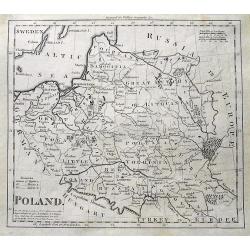
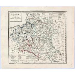
Poland.
An interesting map of Poland, Latvia and Lithuania, showing the various regions and cities. A distance scale in Polish Miles. Shaded lines show the areas moved to Russia ...
Date: London, ca 1802
Selling price: ????
Please login to see price!
Sold in 2019
Europe
Very rare Ottoman printed map of Europe from Jedid Atlas Tercümesi or New Atlas, printed 1218 H. or 1803 in Üsküdar, a part of Istanbul. Title, scale and place names i...
Date: Üsküdar, 1803
Selling price: ????
Please login to see price!
Sold in 2011
Map of England.
Very rare Ottoman printed map of the world in a Mercator projection, centered on Australia.From Jedid Atlas Tercümesi or New Atlas , printed 1218 H. or 1803 in Üsküdar...
Date: Üsküdar, 1803
Selling price: ????
Please login to see price!
Sold
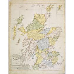
Scotland.
Very rare Ottoman printed map of Scotland with inset of Shetland Islands from Cedid Atlas Tercümesi or New Atlas , printed 1218 H. or 1803 in üsküdar, a part of Istanb...
Date: Vienna/ Üsküdar, 1803
Selling price: ????
Please login to see price!
Sold in 2008

Northern part of Germany.
Very rare Ottoman printed map of northern part of Germany, including Hamburg, Bremen, Hanover, etc., from Jedid Atlas Tercümesi or New Atlas , printed 1218 H. or 1803 in...
Date: Üsküdar, 1803
Selling price: ????
Please login to see price!
Sold
Charte der Leander am Caucasus nach dem besten vorhanden . . .
Very uncommon map of the Ukraine and Caucasus filled with great topographical detail, as well as numerous place names. According to the title the map has been drawn by Jo...
Date: Vienna, 1803
Selling price: ????
Please login to see price!
Sold in 2011
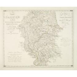
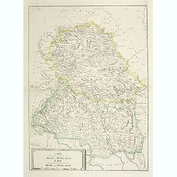
Ost Galizien, IVtes Blatt, enthaltend den Stanislowower Zaleszyker und Tschernowitzer Kreis. . . / IVeme Partie de la Galicie Orientale contenant les Cercles de Stanislawow, de Zaleszyk et de Tschernowitz. . .
Very detailed map of Galicia, Poland after the cartographic sources by Metzburg, Rizzi Zannoni and the Jesuit astronomer Joseph Liesganig. French Titles on the upper righ...
Date: Vienna, Verlag des Kunst und industrie Comptoirs, 1803
Selling price: ????
Please login to see price!
Sold in 2010
![[No tittle] Ancienne N°3 Pologne. . .](/uploads/cache/30627-250x250.jpg)
[No tittle] Ancienne N°3 Pologne. . .
The most eastern section of a larger post road maps maps of Prussia and Poland prepared by David Gilly. (Section DIII). The map show the cities of Bialla, Warka, Warschau...
Date: Berlin, Simon Schropp u. Comp., 1803
Selling price: ????
Please login to see price!
Sold in 2011

Vue de l'Orangerie dans le Parc J. & R(oya)l. prés de Brussels.
Copper engraving by Lorieux after a design of S. Le Febre. Showing the Orangerie at a parc near Brussels. Published by Tessari & Co.
Date: Paris, Tessari, 1803
Selling price: ????
Please login to see price!
Sold in 2017

Ière Vue du Palais Impérial & Royal, près de Bruxelles.
Copper engraving by Lorieux after a design of S. Le Febre. Showing the Imparial Palace near Brussels. Published by Tessari & Co.
Date: Paris, Tessari, 1803
Selling price: ????
Please login to see price!
Sold in 2017
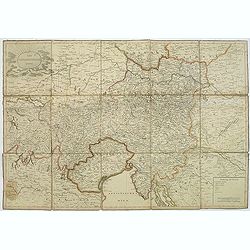
Der Osterreichische Kreiss. Nach dem neusten Grenz=Berichtigung verlast.
Folding map of Austria, engraved by F. Reisser and published by Tranquillo Mollo in Vienna. Maria Laurentio Tranquillo Mollo (born August 10, 1767 in Bellinzona, Ticino, ...
Date: Vienna, 1803
Selling price: ????
Please login to see price!
Sold in 2013
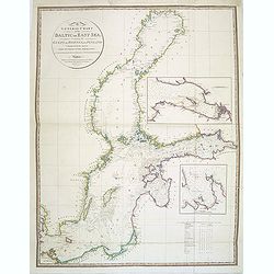
A General Chart of the Baltic or East Sea, including the Gulfs of Botnia and Finland . . .
Detailed and scarce chart of the Baltic and contiguous coasts, from Faden's general atlas. With two insets of the areas around Revel and St. Petersburg.Engraved by Neele ...
Date: London, June 1803
Selling price: ????
Please login to see price!
Sold in 2014
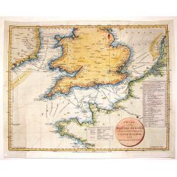
Chart of the British Channel with the Opposite Coast of the United Kingdom and the Republic of France.
Finely detailed chart of the English Channel from the east coast of Ireland to France. With a circular title cartouche and two tables, one that lists the dates of invasio...
Date: London, 1803
Selling price: ????
Please login to see price!
Sold in 2016
![[2 maps] Des europäischen Russlands nördlicher Theil. / Des europäischen Russlands sûdlicher Theil.](/uploads/cache/35343-250x250.jpg)
[2 maps] Des europäischen Russlands nördlicher Theil. / Des europäischen Russlands sûdlicher Theil.
Detailed map of Russia in two sheets, published by Johannes Wach of Augsburg.
Date: Augsburg, 1803
Selling price: ????
Please login to see price!
Sold in 2015
L'Europe Divisee en Ses Principaux Etats et D'Apres le Traite de Paix de Luneville.
Date: Paris, 1803
Selling price: ????
Please login to see price!
Sold in 2016
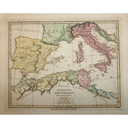
EXPEDITIO HANNIBALIS POENORUM DUCIS
A copper engraved map by John Roper which was published in "Wiklinson's Atlas Classica" in 1803. The map covers the Mediterranean & Islands, Tunisia, Spain,...
Date: London, 1803
Selling price: ????
Please login to see price!
Sold in 2016
Charte von Helvetien und Wallis.
A pleasing map of Switzerland and Northern Italy. Detailed topography with mountains, rivers and lakes. The mapmaker was Goetze from Weimar in 1803. Four informational i...
Date: Weimar, 1803
Selling price: ????
Please login to see price!
Sold in 2016
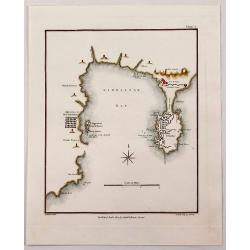
Gibraltar Bay.
A striking map of Gibraltar and Gibraltar Bay with Old Gibraltar across the bay by T. Walsh, and engraved by S. Neele.From “Journal of the Late Campaign in Egypt: Inclu...
Date: London, 1803
Selling price: ????
Please login to see price!
Sold in 2017
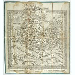
Hamburg.
Plan of the city of Hamburg, drawn up and published by C.L.B. Mirbeck in London, engraved by B. Baker.
Date: London, 1803
Selling price: ????
Please login to see price!
Sold in 2022
Pologne avec les Partages de 1792, 1793 et 1795 . . .
A striking map of Poland, Lithuania and Prussia with notes on the region. The notes within the map show the acquisitions of Russia in Poland in 1773 and 1795, totaling 14...
Date: Paris, 1803
Selling price: ????
Please login to see price!
Sold in 2019
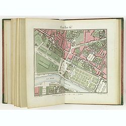
Plan de la ville de Paris dressé géométriquement d'après celui de la Grive, avec ses changements et augmentations.
Charming book forming a plan of Paris engraved by Perrier Oncle and written by Pelicier. Beautiful copy in very fresh colors.
Date: Paris, 1803
Selling price: ????
Please login to see price!
Sold in 2020
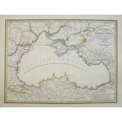
Charte des Schwarzen-Meeres. Nach Murdochischer Projection entworfen und nach den neuesten astronomischen Ortsbestimmungen berichtigt auf der Sternwarte Seeberg bey Gotha. Gezeichnet von Ferd. Götze.
Uncommon map of the Black Sea and surrounding regions. It comprises the region from Wosnesensk to the North to Siwas to the South, from Silistria to the West to Skurali t...
Date: Weimar, 1804
Selling price: ????
Please login to see price!
Sold in 2009
Neu berichtigte Charte von dem Lande der Kirgisen von der Grossen Horde und der südlich angränzenden volker nach einer Russischen Handzeichnung.
An uncommon and finely rendered map of a virtually unknown area.
Date: Weimar, 1804
Selling price: ????
Please login to see price!
Sold in 2009
Carte des deux Cercles de Brody et Brzeczany. Karte deren zween Kreisen von Brody und Brzeczany.
Detailed map of part of Poland from the rare atlas Atlas des Roiaumes de Galicie et de Lodomerie consistant en une Carte générale de ces deux Roiaumes et 10 Cartes. . ....
Date: Vienna, 1798-1804
Selling price: ????
Please login to see price!
Sold in 2011
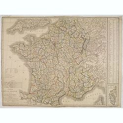
Carte de la France divisée en 108 departemens. . .
General map of France, showing a road-system and 108 departments. In lower right inset map of Corsica (140x70mm.) The map is dated 1804 and "An 12" being the 12...
Date: Paris, An 12 / 1804
Selling price: ????
Please login to see price!
Sold