Browse Listings in Europe
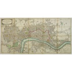
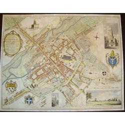
Wallis\'s Plan of the Cities of London and Westminster 1797.
First edition of this folding map covering Pentonville, Stepney, Lambeth and Hyde Park. Hand colored sections laid down on linen. Title on oval at top left. Explanation o...
Date: London, 1797
Selling price: ????
Please login to see price!
Sold in 2009
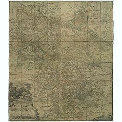
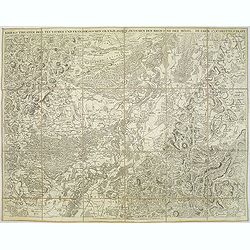
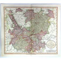
Neu vermehrte post charte der chur Braunschweigischen und angrenzenden lande. . . Von Friedrich Wilhelm Ohsen, ... privatim entworfen im Jahre 1774, verbessert 1777 und 1797.
post road maps map of North-Western Germany, centered on Braunsschweig, including Schaumburg, Grafsch, Lune, Brandenburg.Prepared by Friederich Wilhelm Ohsen in 1774 and ...
Date: Hannover, 1797
Selling price: ????
Please login to see price!
Sold in 2011
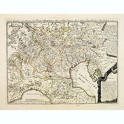
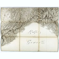
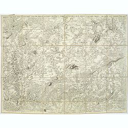
Neue karte von den Franzosischen kriegs Schauplatze in ober and Mittel Italien, . . .
Scarce map of northern part of Italy, with Austra showing campaigns of 1797 in the French Revolutionary Wars. The map indicated the different battle places with dates in ...
Date: Leipzig, 1797
Selling price: ????
Please login to see price!
Sold in 2018
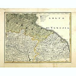
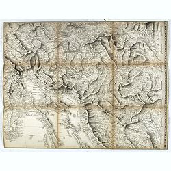
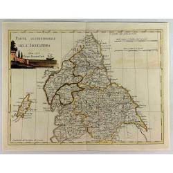
(Untitled map of east central Italy)
Including the towns of Bologna, Ravenna, Rimini, Ancona and the River Arno with Florence in lower left corner. One page from his multi sheet map "Carta del Territori...
Date: Florence, 1797
Selling price: ????
Please login to see price!
Sold
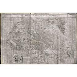
Plan Geometral De Paris Et De Ses Fauxbourgs...
This exceptionally large, rare plan de Paris is a revision of De Vaugondy's smaller plan of 1783. This print was published by Delamarche who was the successor of Vaugondy...
Date: Paris, 1797
Selling price: ????
Please login to see price!
Sold in 2019
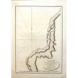
Plan de la Baie d'Estaing.
Large map of the Bay of D'Estaing on the coast of Tchoka in the Uglegorsk Region of Russia. It is from "ATLAS DU VOYAGE DE LA PEROUSE". Perouse set sail from Fr...
Date: Paris, 1797
Selling price: ????
Please login to see price!
Sold in 2015
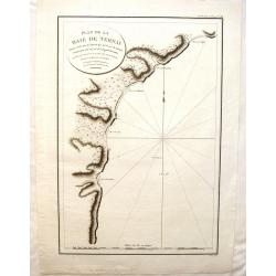
Plan de la Baie de Ternai.
A crisp clear map of the Bay of Ternai in Tartary (Russian Provinces). It is from "ATLAS DU VOYAGE DE LA PEROUSE". Perouse set sail from France in 1785 to conti...
Date: Paris, 1797
Selling price: ????
Please login to see price!
Sold in 2015
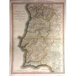
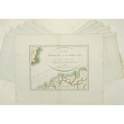
Chorographical Map of the Kingdom of Portugal divided into its Grand Provinces
A very large, pleasant map of Portugal, with roads, provinces, settlements and towns published by William Faden in 1797, Filled with detail including mountains.William Fa...
Date: London, 1797
Selling price: ????
Please login to see price!
Sold in 2016
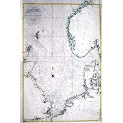
Charta öfver Nordsjön...
Very rare and large Swedish sea-chart of the North Sea between the British Isles, Norway, Denmark, and the Netherlands. Includes Trondheim, Christiania (Oslo), Fredriksta...
Date: Stockholm, 1797
Selling price: ????
Please login to see price!
Sold in 2016
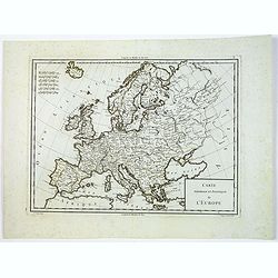
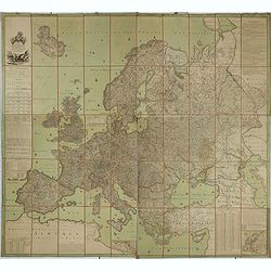
Carte Generale et Politique de L'Europe.
Engraved by Tardieu for Mentelle's "Atlas Universel de Géographie Physique et Politique, Ancienne et Moderne, Présenté a l'Instruction des Écoles Centrales, Pour...
Date: Paris, ca 1797
Selling price: ????
Please login to see price!
Sold in 2019
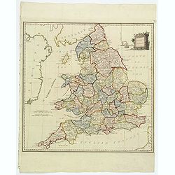
Present Britain.
A fully colored map of England and Wales from An Universal Atlas Consisting of a Complete Set of Maps, peculiarly adapted to illustrate and explain ancient and modern geo...
Date: London, 1797
Selling price: ????
Please login to see price!
Sold in 2021
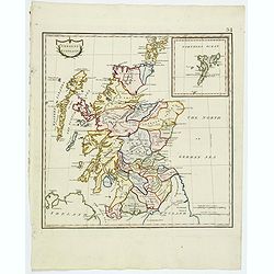
Present Scotland.
A fully colored map of Scotland, with the usual inset of the Shetland Islands from An Universal Atlas Consisting of a Complete Set of Maps, peculiarly adapted to illustra...
Date: London, 1797
Selling price: ????
Please login to see price!
Sold in 2020
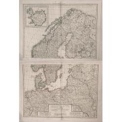
Les Cournonnes du Nord, le Danemarck, la Norwege, L'Islande et la Suede...
Huge two part map of northern Europe including Denmark, Norway, Sweden, European Russia, Poland, Germany. France, with an insert of Iceland. Charles-François Delamar...
Date: Paris, 1797
Selling price: ????
Please login to see price!
Sold in 2019
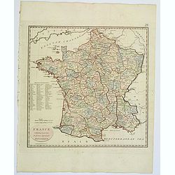
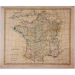
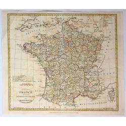
France, exhibiting at one view its former & present Divisions.
A fully colored map of France from An Universal Atlas Consisting of a Complete Set of Maps, peculiarly adapted to illustrate and explain ancient and modern geography, S.J...
Date: London, 1797
Selling price: ????
Please login to see price!
Sold in 2021
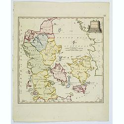
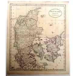
Denmark.
A fully colored map of Denmark from An Universal Atlas Consisting of a Complete Set of Maps, peculiarly adapted to illustrate and explain ancient and modern geography, S....
Date: London, 1797
Selling price: ????
Please login to see price!
Sold in 2021
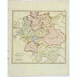
Present Germany.
A fully colored map of (the then) Germany from An Universal Atlas Consisting of a Complete Set of Maps, peculiarly adapted to illustrate and explain ancient and modern ge...
Date: London, 1797
Selling price: ????
Please login to see price!
Sold in 2021
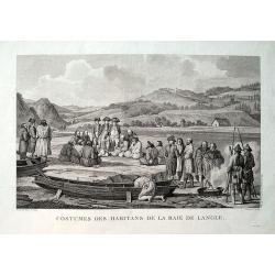
Costumes des habitans de la Baie de Langle.
From the important 1797 French edition. A fine engraved view showing local people and sailors near today's Tomari Bay, Sakhalin. Dessine par Duche-de Vancy. Grave par Cat...
Date: Paris, 1797
Selling price: ????
Please login to see price!
Sold in 2019
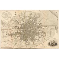
Plan of the City of Dublin Surveyed for Use of the Division of Justices, to Which have been Added Plans of the Canal Harbor and its Junction with the Grand Canal...
This is a rare separately issued map of Dublin, Ireland as it was at the end of what can be considered a rather prosperous century for the nation's capital and largest ci...
Date: London, 1797
Selling price: ????
Please login to see price!
Sold in 2023

Tilburg (Market place)
Extremely rare print of Market place of Tilburg from Reizen door de Mayorij by Hanewinkel.
Date: Amsterdam 1798
Selling price: ????
Please login to see price!
Sold
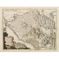
Campagna di Roma Di nuova Projezione. . .
A very striking map of the area south east of Rome, engraved by G.Pitteri embellished with an colored pictorial title cartouche.
Date: Venice, 1798
Selling price: ????
Please login to see price!
Sold in 2015
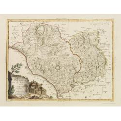
Il Patrimonio di S.Pietro e la Sabina. . .
A very striking map of the area north of Rome, engraved by G.Pitteri embellished with an colored pictorial title cartouche.
Date: Venice, 1798
Selling price: ????
Please login to see price!
Sold in 2015
A Plan of the City of Canterbury & the adjoining Suburbs...
A beautiful, sought after plan of Canterbury as seen towards the end of the eighteenth century. The work contains four insets: 1) "The North View of St. Augustine's ...
Date: London, dated 1798
Selling price: ????
Please login to see price!
Sold in 2008
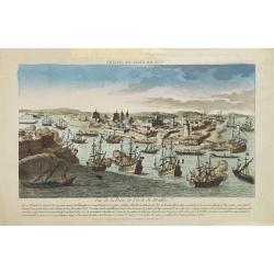
Vue de la Prise de l'Isle de Malthe.
A so-called optical print. A very decorative and extremely rare view of the siege of Valetta by Napoleon Bonaparte in 1797. French rule lasted only two years, for in 1800...
Date: Paris, 1798
Selling price: ????
Please login to see price!
Sold in 2008
Specialkarte der Gegenden zwischen dem Rhein und der Saar. . . / Carte des pais situes entre le rhin et la sarre depuis spire. . .
Map of the frontier between Germany and France. Beautiful map showing the relief. Engraved by B.F. Leizelt.
Date: Augsburg, 1798
Selling price: ????
Please login to see price!
Sold in 2014
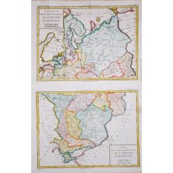
Carte de la Partie Septentrionale/ Meridionale de la Russie Euopéenne.
Two maps together depicting European Russia. From Brunet's 'Histoire Universelle, depuis le commencement du monde jusqu'a present'.Louis Brion de la Tour (1756-1823), Fre...
Date: Paris, 1790-1798
Selling price: ????
Please login to see price!
Sold in 2020
Carte de l'Europe dediée a Son Altesse royale Monseigneur Charles Louis archiduc d'Autriche, prince royal de Hongrie et de Bohéme, chevalier de la Toison d'Or, Grand-Croix de l'ordre militaire de Marie-Thérése . . .
Wall map of Europe during the regime of Napoleon. Engraved by Joannes Berken. With a dedication to Archduke Charles of Austria, ( 5 September 1771 – 30 April 1847) who ...
Date: Paris / Vienna 1798
Selling price: ????
Please login to see price!
Sold in 2015
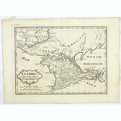
La Crimea con alcuni luoghi adiacenti Siena presso Pazzini Carli - Ago: Costa inc.
Detailed map of Crimea from a rare atlas which is published in Siena by Pazzini Carli between 1798 and 1800. The map most likely prepared by L ' abbot Bartolomeo Borghi (...
Date: Siena, ca. 1798
Selling price: ????
Please login to see price!
Sold in 2015
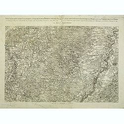
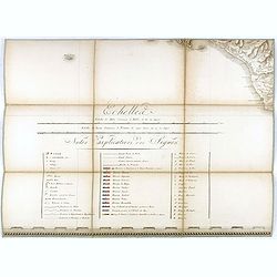
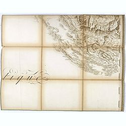
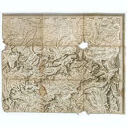
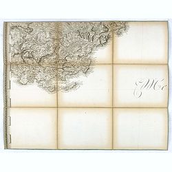
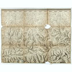
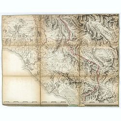
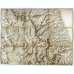
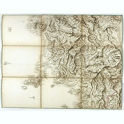
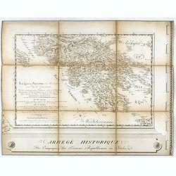
(Separate sheet from ) Carte générale du théâtre de la guerre en Italie et dans les Alpes.
The complete title of the map is "Carte générale du théâtre de la Guerre en Italie et dans les Alpes depuis le passage du Var le 29 septembre 1792 jusqu'à l'ent...
Date: Milan, 1798
Selling price: ????
Please login to see price!
Sold in 2017
(Separate sheet from ) Carte générale du théâtre de la guerre en Italie et dans les Alpes.
The complete title of the map is "Carte générale du théâtre de la Guerre en Italie et dans les Alpes depuis le passage du Var le 29 septembre 1792 jusqu'à l'ent...
Date: Milan, 1798
Selling price: ????
Please login to see price!
Sold in 2018
(Separate sheet from ) Carte générale du théâtre de la guerre en Italie et dans les Alpes.
The complete title of the map is "Carte générale du théâtre de la Guerre en Italie et dans les Alpes depuis le passage du Var le 29 septembre 1792 jusqu'à l'ent...
Date: Milan, 1798
Selling price: ????
Please login to see price!
Sold in 2017
(Separate sheet from ) Carte générale du théâtre de la guerre en Italie et dans les Alpes.
The complete title of the map is "Carte générale du théâtre de la Guerre en Italie et dans les Alpes depuis le passage du Var le 29 septembre 1792 jusqu'à l'ent...
Date: Milan, 1798
Selling price: ????
Please login to see price!
Sold in 2016
(Separate sheet from ) Carte générale du théâtre de la guerre en Italie et dans les Alpes.
The complete title of the map is "Carte générale du théâtre de la Guerre en Italie et dans les Alpes depuis le passage du Var le 29 septembre 1792 jusqu'à l'ent...
Date: Milan, 1798
Selling price: ????
Please login to see price!
Sold in 2017
(Separate sheet from ) Carte générale du théâtre de la guerre en Italie et dans les Alpes.
The complete title of the map is "Carte générale du théâtre de la Guerre en Italie et dans les Alpes depuis le passage du Var le 29 septembre 1792 jusqu'à l'ent...
Date: Milan, 1798
Selling price: ????
Please login to see price!
Sold in 2018
(Separate sheet from ) Carte générale du théâtre de la guerre en Italie et dans les Alpes.
The complete title of the map is "Carte générale du théâtre de la Guerre en Italie et dans les Alpes depuis le passage du Var le 29 septembre 1792 jusqu'à l'ent...
Date: Milan, 1798
Selling price: ????
Please login to see price!
Sold in 2017
(Separate sheet from ) Carte générale du théâtre de la guerre en Italie et dans les Alpes.
The complete title of the map is "Carte générale du théâtre de la Guerre en Italie et dans les Alpes depuis le passage du Var le 29 septembre 1792 jusqu'à l'ent...
Date: Milan, 1798
Selling price: ????
Please login to see price!
Sold in 2016
(Separate sheet from ) Carte générale du théâtre de la guerre en Italie et dans les Alpes.
The complete title of the map is "Carte générale du théâtre de la Guerre en Italie et dans les Alpes depuis le passage du Var le 29 septembre 1792 jusqu'à l'ent...
Date: Milan, 1798
Selling price: ????
Please login to see price!
Sold in 2016
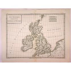
Isles Britanniques Premiere Carte Generale et Physique.
A detailed copper engraving map of the British Isles by Mentelle and Chanlaire from their "Atlas Universel". Published in Paris in 1798. The map shows mountains...
Date: Paris, 1798
Selling price: ????
Please login to see price!
Sold in 2017
France Divided Into Provinces.
A fine map of France with outline color delineating the provinces. Published in London in 1798 by G.G. & J Robinson, and engraved by S. Neele.
Date: London, 1798
Selling price: ????
Please login to see price!
Sold in 2017
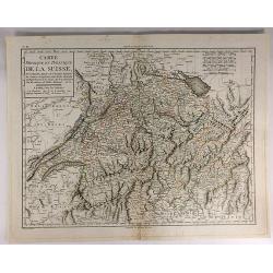
Carte Physique et Politique de la Suisse.
A finely engraved map of Switzerland issued in an “Atlas Universel de Géographie Physique et Politique, Ancienne et Moderne”, which was published in by Mentelle and...
Date: Paris, 1798
Selling price: ????
Please login to see price!
Sold in 2017
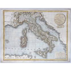
Carte Generale de L'Italie Redigee Sur les Observations les Plus Authentiqueues.
A decorative and large format map of Italy from the age of Napoleon. Produced by Delamarche in 1798. Charles Delamarche (1740-1817) entered the mapmaking industry as succ...
Date: Paris, 1798
Selling price: ????
Please login to see price!
Sold in 2018
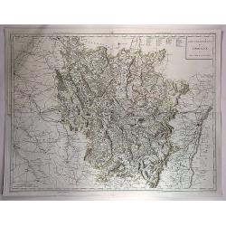
Gouvernements de Lorraine et Des Trois Eveches.
A large, detailed copper engraving map of the province of Lorraine, France by Mentelle and Chanlaire, from their "Atlas Universel". Published in Paris in 1798.
Date: Paris, 1798
Selling price: ????
Please login to see price!
Sold in 2018
Parte Settentrionale Dell Inghilterra.
A fine Italian map of the northern part of England. It features a title cartouche "Siena 1795 Near Pazzini Carli". The sheet comes from the rare geographical At...
Date: Siena, 1798
Selling price: ????
Please login to see price!
Sold in 2020
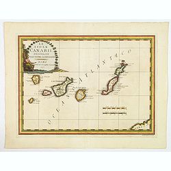
Le Isole Canarie Delineate Sulle Ultime Osservazioni.
A scarce map of the Canaries, from Cassini's atlas the Nuovo Atlante Geografico Universale. Enhanced with a large decorative title cartouche, and a pair of mileage scales...
Date: Rome, 1798
Selling price: ????
Please login to see price!
Sold in 2023
![[A Manuscript map and 3 town views of Malta and Valletta.]](/uploads/cache/24469-250x250.jpg)
[A Manuscript map and 3 town views of Malta and Valletta.]
A manuscript map of Malta and Gozo in French, topped by a panoramic view of Valetta with the Knight's ships in the foreground (Veue de la Cité Valette du costé du grand...
Date: Malta, ca.1768 - 1798
Selling price: ????
Please login to see price!
Sold
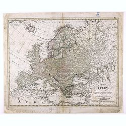
Charte von Europa Nach den neuesten Astronomischen Ortsbestimmungen entworfen und berichtiget auf der Sternwarte Seeberg, bey Gotha. . .
Nice map of Europa.
Date: Nuremberg, 1798
Selling price: ????
Please login to see price!
Sold in 2020
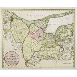
Karte von Danzig, Elbing und Marienburg odert..
Uncommon map centered on Danzig and Elbing. Very detailed, prepared by Johann Fridrich Endersch (1705-1769). Engraved by A.Amon.
Date: Vienna, 1799
Selling price: ????
Please login to see price!
Sold in 2009
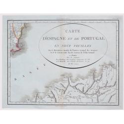
Carte d'Espagne et de Portugal en neuf feuilles.
Together forming a large wall map (970x126cm) of Spain and Portugal.
Date: Paris, 1799
Selling price: ????
Please login to see price!
Sold
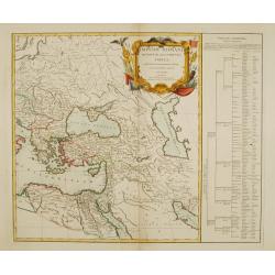
Imperii Romani occidentis..
Detailed map of the eastern part of the roman Empire showing Greece, Near East, Egypt and Libya. Very decorative title cartouche surrounded with roman legion's arms and e...
Date: Paris 1799
Selling price: ????
Please login to see price!
Sold
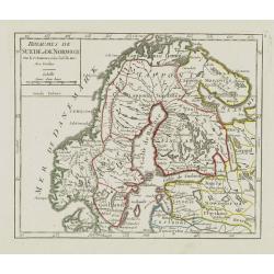
Royaumes de Suede et de Norwege..
Small general map of Scandinavia. From Atlas Portatif Universel, by Robert de Vaugondy.Page 8 outside border top right. Mary Sponberg Pedley does not mention a state with...
Date: Paris, ca. 1748-1799
Selling price: ????
Please login to see price!
Sold in 2019
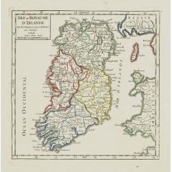
Isle et Royaume d'Irlande.
Nice small map of Ireland. From Atlas Portatif Universel, by Robert de Vaugondy.Page 7 outside border top right. Mary Sponberg Pedley does not mention a state without dat...
Date: Paris, 1748-1799
Selling price: ????
Please login to see price!
Sold
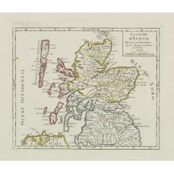
Royaume d\'Ecosse.
Nice small map of Scotland. From Atlas Portatif Universel, by Robert de Vaugondy.Page 6 outside border top right. Mary Sponberg Pedley does not mention a state without da...
Date: Paris, 1748-1799
Selling price: ????
Please login to see price!
Sold in 2008
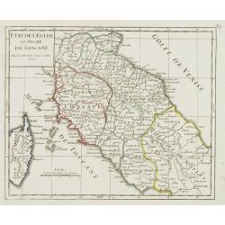
Etat de l'Eglise et Duché de Toscane.
Detailed small map of central Italy, including most part of Corsica. From Atlas Portatif Universel, by Robert de Vaugondy.Unrecorded state with page 59 outside border top...
Date: Paris, 1799
Selling price: ????
Please login to see price!
Sold in 2008
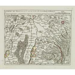
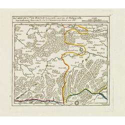
III. Cours du Rhin où sont les environs de Brisach, Newenburg, Fribourg &c.
Small detailed map illustrating the stretch of the Rhine which flows between Nuremburg and Breisach am Rhein.From Atlas Portatif Universel, by Robert de Vaugondy.Page 34c...
Date: Paris, 1799
Selling price: ????
Please login to see price!
Sold in 2021
La Tartaria indipendente. . .
Map of Central Asia from the eastern shore of the Black Sea to the borders of China, with Georgia, the Caspian Sea, Turkestan, Usbekistan, Samarkand, Bokhara, Tibet and B...
Date: Rome, 1799
Selling price: ????
Please login to see price!
Sold in 2009
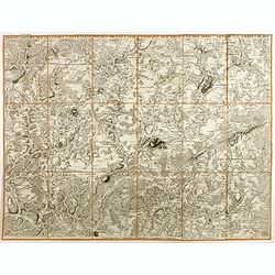
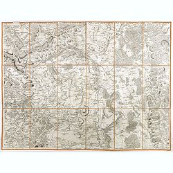
Kriegs Theater der teutschen und franzoesischen Graenzlanden zwischen dem Rhein und der Mosel, im Jahr 1796 : drittes Blatt.
Very detailed map of Pfalz from a six-sheet map prepared by Peter Dewarat, with a dedication by Johann Ludwig Christian Rheinwald, (1763 - 1811) who was a lawyer and hist...
Date: D. Artaria, Mannheim, 1795-1799
Selling price: ????
Please login to see price!
Sold in 2013
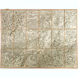
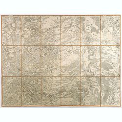
Kriegs Theater der teutschen und franzoesischen Graenzlanden swischen dem Rhein und der Mosel, im Jahr 1797 : viertes Blatt.
Very detailed map of Pfalz from a six-sheet map prepared by Peter Dewarat, with a dedication by Johann Ludwig Christian Rheinwald, (1763 - 1811) who was a lawyer and hist...
Date: D. Artaria, Mannheim, 1794-1799
Selling price: ????
Please login to see price!
Sold in 2013
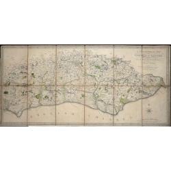
A Topographical Map of the County of Sussex Reduced from the Large survey in four sheets by Thomas Gream. . .
Folding Map of Sussex engraved on paper laid onto linen, with 6 folds, 380 x 800mm opened out, Scale: 6 miles to 2.5 inches. The map has original hand-coloring showing ...
Date: London, 1799
Selling price: ????
Please login to see price!
Sold in 2016
Denmark From the Best Authorities.
Finely detailed map of Denmark and Holstein by Russell.
Date: London, 1799
Selling price: ????
Please login to see price!
Sold in 2016
A New Map of the Circles of the Upper and Lower Rhine
A detailed, hand-colored antique map by the prominent English cartographer John Cary in London in 1799, covering an area from Westphalia and Lower Saxony in the north to ...
Date: London, 1799
Selling price: ????
Please login to see price!
Sold in 2019
Der Schwaebische Nebst den Oesterreichischen Besizungen in Schwaben.
A fine detailed map of Swabia in southern Germany with small inset map of the Principality of Lichtenstein. Also includes parts of Austria and Switzerland. By Johann Walc...
Date: Augsburg, 1799
Selling price: ????
Please login to see price!
Sold in 2016
Cercle de Franconie divisé en ses princip.ux Etats.
Small detailed map of the northern part of Bavaria. From Atlas Portatif Universel, by Robert de Vaugondy.Edited by : "Au dépôt de Géographie, Rue Geoffroy Langevi...
Date: Paris, 1799
Selling price: ????
Please login to see price!
Sold in 2019
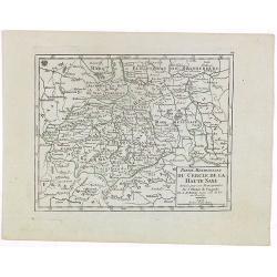
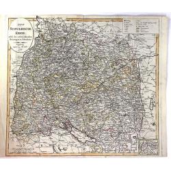
Partie Meridionale du Cercle de la Haute Saxe..
Small detailed map of part of Germany, approximatively corresponding to the today states of Thüringen, Saxony and Saxony-Anhalt.Showing Berlin in the upper part. From At...
Date: Paris, 1799
Selling price: ????
Please login to see price!
Sold in 2020
France Divided Into Metropolitan Circles and Departments.
A fine map of France divided into Metropolitan Circles and Departments by the English map publisher Clement Cruttwell. The French Department system was established in 179...
Date: London, 1799
Selling price: ????
Please login to see price!
Sold in 2018
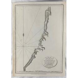
Plan of la Baie de Langle.
A simple map of the bay on the west shore of Sakalin Island. Relief shown by hachures. From the English edition that was published in London by G.G. & J. Robinson in ...
Date: London, 1799
Selling price: ????
Please login to see price!
Sold in 2018

Tombs of Baie de Castries.
An interesting engraving of tombs in the Baie de Castries, in the Okhotsk Sea in eastern Russia. Published in London by G.G. & J. Robinson in 1799. Engraved by Heath....
Date: London, 1799
Selling price: ????
Please login to see price!
Sold in 2018
Kriegs Theater der teutschen und franzoesischen Graenzlanden swischen dem Rhein und der Mosel, im Jahr 1797 : viertes Blatt.
Very detailed map of Pfalz from a six-sheet map prepared by Peter Dewarat, with a dedication by Johann Ludwig Christian Rheinwald, (1763 - 1811) who was a lawyer and hist...
Date: D. Artaria, Mannheim, 1794-1799
Selling price: ????
Please login to see price!
Sold in 2020
Kriegs Theater der teutschen und franzoesischen Graenzlanden swischen dem Rhein und der Mosel, im Jahr 1796 : drittes Blatt.
Very detailed map of Pfalz from a six-sheet map prepared by Peter Dewarat, with a dedication by Johann Ludwig Christian Rheinwald, (1763 - 1811) who was a lawyer and hist...
Date: D. Artaria, Mannheim, 1794-1799
Selling price: ????
Please login to see price!
Sold in 2019
Kriegs Theater der teutschen und franzoesischen Graenzlanden swischen dem Rhein und der Mosel, im Jahr 1796 : zweites Blatt.
Very detailed map of Pfalz with Mainz from a six-sheet map prepared by Peter Dewarat, with a dedication by Johann Ludwig Christian Rheinwald, (1763 - 1811) who was a lawy...
Date: D. Artaria, Mannheim, 1794-1799
Selling price: ????
Please login to see price!
Sold in 2019
Kriegs Theater der teutschen und franzoesischen Graenzlanden swischen dem Rhein und der Mosel, im Jahr 1796 : erstes Blatt.
Very detailed map of Pfalz from a six-sheet map prepared by Peter Dewarat, with a dedication by Johann Ludwig Christian Rheinwald, (1763 - 1811) who was a lawyer and hist...
Date: D. Artaria, Mannheim, 1794-1799
Selling price: ????
Please login to see price!
Sold in 2019
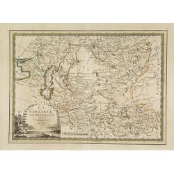
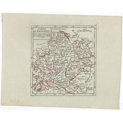
IX. Carte du C.té de Haynaut où sont les environs de Philippeville, Marienbourg, Rocroix &c.
Attractive small map showing an area straddling the border between France and Belgium. It shows Philippeville, Marienbourg, Rocroi, Couvin and Chimay.From Atlas Portatif ...
Date: Paris, 1799
Selling price: ????
Please login to see price!
Sold in 2020
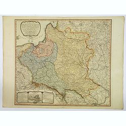
A Map of The Kingdom of Poland and Grand Dutchy of Lithuania including Samogitia and Curland, divided into their Dismemberments. . .
A scarce, second edition map of Poland by William Faden published in London in 1799. The map itself is based on the Rizzi-Zannoni 24-sheet map of 1772, that was commissio...
Date: London, 1799
Selling price: ????
Please login to see price!
Sold in 2019
Carte D'Espagne et de Portugal en Neuf Feuilles ...
Fine unusual 1799 Mentelle & Chanlaire's copper engraved map covering part of Murcia, south-eastern Spain, centered on Cartagena. The map covers also northern porti...
Date: Paris, 1799
Selling price: ????
Please login to see price!
Sold in 2021
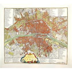
A Plan of the City of Paris.
A handsome and finely engraved plan of Paris based on late 18th century information. The work contains three legends identifying 78 points of interest, including major la...
Date: London, dated 1800
Selling price: ????
Please login to see price!
Sold
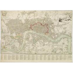
London and Westminster.
Title with engraving of Father Thames top right. At the bottom right, a compass rose and at the bottom center, a scale bar. Map divided into rectangles and lettered for r...
Date: London, 1800
Selling price: ????
Please login to see price!
Sold in 2016
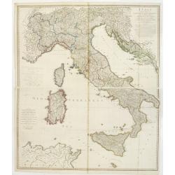
Italy with the Addition of the Southern Parts of Germany as far as.. the Illyric Islands..
Comprehensive map of Italy printed on 4 sheets, joined 2 by 2. Good detail is given with settlements, common and post roads, etc. Relief shown pictorially.
Date: London, 1800
Selling price: ????
Please login to see price!
Sold in 2008
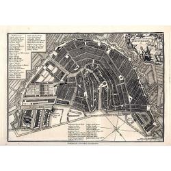
A plan of the City of Amsterdam
Very detailed plan of Amsterdam with a letter key (1-51) identifying important buildings, markets, and places. With a decorative title cartouche featuring a harbor scene....
Date: London, 1800
Selling price: ????
Please login to see price!
Sold in 2008