Browse Listings in Catch All
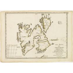
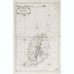
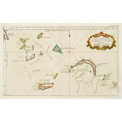
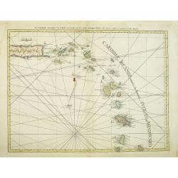
Les Isles du Spitsberg.
Fine map of Spitsbergen. George Louis Le Rouge was active from 1740- till 1780 as a publisher, and was appointed engineer for the King of France. From his Atlas Nouveau P...
Date: Paris 1756
Selling price: ????
Please login to see price!
Sold
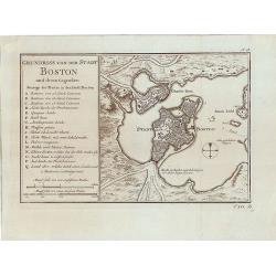
Grundriss von der Stadt Boston und ihren Gegenden.
Rare German edition of the Bellin plan of the city of Boston, its harbor and its surrounding area.The most important buildings, forts with their amount of cannons, lighth...
Date: Paris, 1756
Selling price: ????
Please login to see price!
Sold in 2014
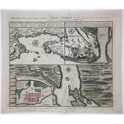
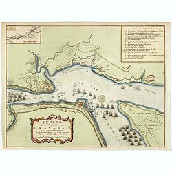
VORSTELLUNG einiger Gegender und Plaetze in NORD-AMERICA
A copperplate, old colored map consisting of three different Plans, issued during the early days of the Seven Years’ War for commercial reasons. Heir Homann produced th...
Date: Nuremberg, 1756
Selling price: ????
Please login to see price!
Sold in 2017
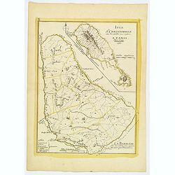
L'Isle St. Christophle. . . La Barbade. . .
Two maps on one sheet showing Barbados and St. Christophers. Physical map detail is depicted rather than topographical information. A few place names, capes and bays are ...
Date: Paris, 1756
Selling price: ????
Please login to see price!
Sold in 2019
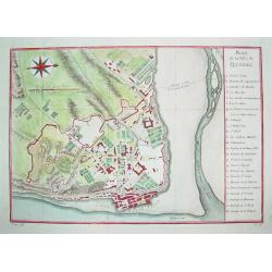
Plan de la Ville de Quebec.
A beautifully engraved mid-18th century plan of Quebec. The work contains a 24 point legend which identifies key sites and places of interest. Enhanced with a compass ros...
Date: Paris, c. 1757
Selling price: ????
Please login to see price!
Sold
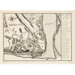
Grundriss der Stadt Quebec.
Plan of Quebec with table of explanations to the right side. From a German edition of Prevost's 'Hist. des Voyages'. Jacques Nicolaas Bellin (1703-1772) was one of the mo...
Date: Paris 1757
Selling price: ????
Please login to see price!
Sold
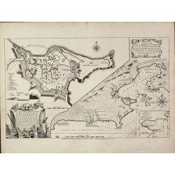
A Plan of the City, and Fortifications, of Louisburg, from a Survey made by Richard Gridley / A Plan of the City and Harbour of Louisburg
Important and very rare map describing the first siege of Louisbourg in 1745The copper engraved map published by Thomas Jefferys in 1757 showing the Siege of Louisbourg, ...
Date: London, 1757
Selling price: ????
Please login to see price!
Sold in 2011
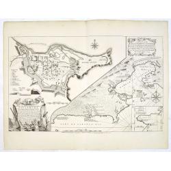
A Plan of the City, and Fortifications, of Louisburg, from a Survey made by Richard Gridley / A Plan of the City and Harbour of Louisburg.
Important and very rare map describing the first siege of Louisbourg in 1745 - Very rare first state of the Gridley/Jefferys plan of the 1745 Siege of Louisbourg.Large Fr...
Date: London, Thomas Jefferys, 20 April 1757
Selling price: ????
Please login to see price!
Sold in 2013
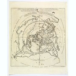
A Physical Planisphere wherein are represented all the known Lands and Seas in the Great Chains of Mountains. . .
This is the elegant 1757 Philippe Buache map of the world represented on an unusual polar projection rendered from the North Pole. The map covers from the North Pole Arct...
Date: London, 1757
Selling price: ????
Please login to see price!
Sold in 2019
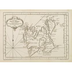
Carte du Spits-Berg..
A good engraved map of Spitsbergen. The geographical features are typical with somewhat exaggerated bays and inlets. From l'Histoire générale des voyages .
Date: Paris 1758
Selling price: ????
Please login to see price!
Sold
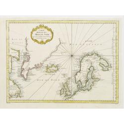
Carte Réduite des Mers du Nord Pour servir a l'Histoire Generale des Voyages.
General map of the Arctic Region including part of Canada, Greenland, Iceland, Scandinavia and part of the Russian shores.
Date: Paris 1758
Selling price: ????
Please login to see price!
Sold
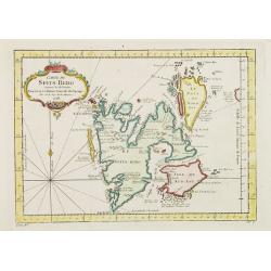
Carte Du Spits-Berg Suivant les Hollandois . . . 1758
A decorative map of Spitsbergen (Svalbard) with the adjacent islands of Franz Josef Land and Jan Mayan. The geographical features are typical with somewhat exaggerated ba...
Date: Paris, 1758
Selling price: ????
Please login to see price!
Sold in 2008
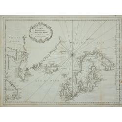
Carte Réduite des Mers du Nord Pour servir a l'Histoire Generale des Voyages.
Folding map of the Arctic Region including part of Canada, Greenland, Iceland, Scandinavia and part of the Russian shores.From l'Histoire générale des voyages. Jacques ...
Date: Paris, 1758
Selling price: ????
Please login to see price!
Sold in 2011
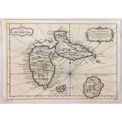
Carte de l'Isle de la Guadeloupe.
Jacques Bellin's elegant map of Guadeloupe, and the adjacent islands of Les Sainte and Marie Galante. With excellent topographical details, many place names, radiating rh...
Date: Paris, 1758
Selling price: ????
Please login to see price!
Sold in 2020
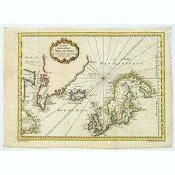
Carte Réduite des Mers du Nord Pour servir a l'Histoire Generale des Voyages.
A lovely general map of the Arctic Regions, including parts of Western, Canada, Greenland, Iceland, Scandinavia, the British Isles, and portions of western Russian shores...
Date: Paris, 1758
Selling price: ????
Please login to see price!
Sold in 2018
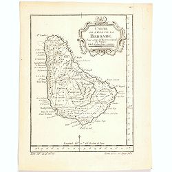
Carte de l'Isle de la Barbade. . .
One of the finest early maps or charts of Barbados. The island is divided into parishes and details cities & towns, mountains, forests, anchorages, shouls, and rocks....
Date: Paris, 1758
Selling price: ????
Please login to see price!
Sold in 2020
Quebek de hoofdstad van Kanada.
A handsome copper engraved map, closely copied from a similar plan by Thomas Jeffreys. The map depicts the English siege and attack on Quebec, which resulted in the city'...
Date: Amsterdam, 1759
Selling price: ????
Please login to see price!
Sold in 2019
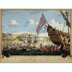
A View of the Landing the New England Forces in ye Expedition against Cape Breton, 1745.
Depicting a view of the fortress siege at Louisbourg in New France in 1745, done by J. Steven and "Printed for John Bowles at the Black Horse in Cornhill & Carri...
Date: London, ca. 1760
Selling price: ????
Please login to see price!
Sold in 2017
Carte de l'Isle de la Grenade Dressee au Depost des Cartes et Plans de la Marine...
Large-scale sea chart of this mountainous island in the Windward Islands with great detail of the roads, villages, and ports. Above the decorative title cartouche is a pr...
Date: Amsterdam, 1760
Selling price: ????
Please login to see price!
Sold in 2015
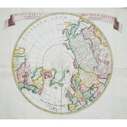
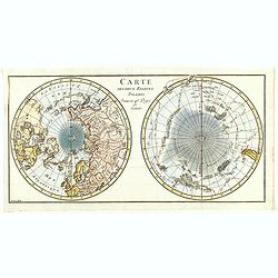
Nuova Carta del Polo Arctico secondo l'ultime offervazioni.
A lovely map centered on the North Pole and the surrounding countries. From the Italian edition of Thomas Salmon's 'Modern History: or, the present state of all Nations. ...
Date: Venice, 1740-1762
Selling price: ????
Please login to see price!
Sold in 2020
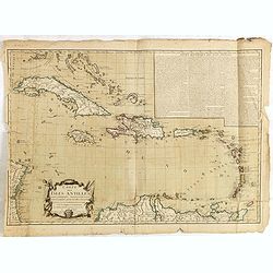
Carte des Isles Sittuees au Nord de St. Domingue..
Decorative map of the islands north of S.Domingo. Showing soundings and much detail.
Date: Paris 1763
Selling price: ????
Please login to see price!
Sold
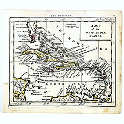
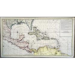
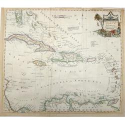
A map of West India Islands.
Uncommon miniature map of Caribbean with the southern tip of Florida, engraved by Thomas Kitching for "A New General and Universal Atlas Containing Forty five Maps b...
Date: London, 1761-1763
Selling price: ????
Please login to see price!
Sold in 2017
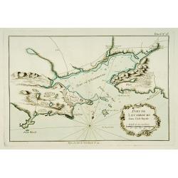
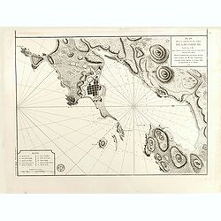
Port de Louisbourg dans l'Isle Royale.
This chart shows the harbour of Louisburg in the southeast portion of the island Nova Scotia in great detail.The only issue of this version of Bellin's map, slightly larg...
Date: Paris 1764
Selling price: ????
Please login to see price!
Sold
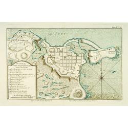
Plan de la ville de Louisbourg dans l'Isle Royale.
A plan of the city of Louisburg on l'Isle Royale.The only issue of this version of Bellin's map, slightly larger than the common version. Depths shown by soundings.From B...
Date: Paris 1764
Selling price: ????
Please login to see price!
Sold
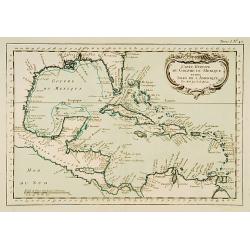
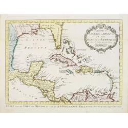
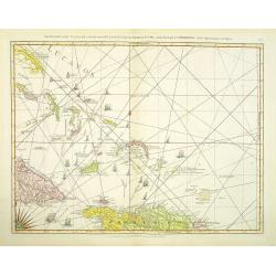
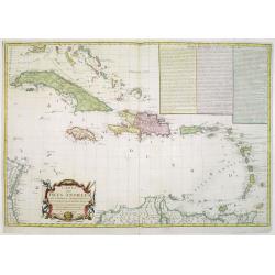
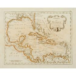
Carte Réduite du Golf du Mexique et des Isles de l'Amérique
This chart shows the Caribbean islands.The only issue of this version of Bellin's map, slightly larger than the common version. From Bellin's Petit atlas maritime.Tome I ...
Date: Paris 1764
Selling price: ????
Please login to see price!
Sold
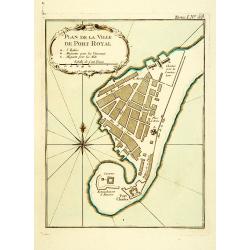
Plan de la Ville de Port Royal.
Plan of the city of Port Royal on Arcadia.The only issue of this version of Bellin's map, slightly larger than the common version. From Bellin's Petit atlas maritime.Tome...
Date: Paris 1764
Selling price: ????
Please login to see price!
Sold
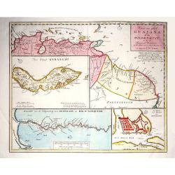
Kaart van geheel Guajana of de Wilden -Kust / Het Eiland Kurassau. / De Haven en 't Kasteel van Kurassau / Kaart van de Volksplanting aan Demerary en Rio d'Essequebo.
Izaak Tirion (d. 1769) Amsterdam publisher. His ' Nieuwe en beknopte handatlas' saw 6 editions between before 1740 and after 1784. Also ' Tegenwoordige staat van alle vol...
Date: Amsterdam, 1765
Selling price: ????
Please login to see price!
Sold in 2017
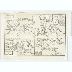
A Plan of the Town and Harbour of Louisbourg. . . A Plan of the City and Harbour of Havana. . . A Plan of the Town and Harbour of Cartagena. . .
"A Plan of the Town and Harbour of Louisbourg [on sheet with] A Plan of the City and Harbour of Havana [and] A Plan of the Town and Harbour of Cartagena [and] A Plan...
Date: London, 1765
Selling price: ????
Please login to see price!
Sold in 2020
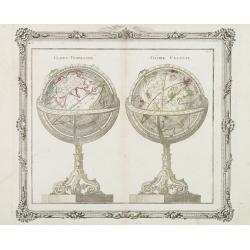
Globe Terestre - Globe Céléste.
A decorative copper plate of a large pair of globes on ornate rococo-style bases. The Globe Terrestre is centered on the Eastern Hemisphere. The Globe Celeste is showing ...
Date: Paris, 1766
Selling price: ????
Please login to see price!
Sold in 2008

Three Copper Engravings by DIDEROT Featuring Asronomical Instruments (Heliometer & Micrometer)
This set of three (3) antique prints originate from: 'The Encyclopédie ou Dictionnaire raisonné des sciences, des arts et des métiers, par une Société de Gens de let...
Date: Paris, 1771
Selling price: ????
Please login to see price!
Sold in 2017

Three Copper Engraved Diderot Astronomical Instruments (Secteur & Heliometer).
This set of three (3) antique prints originate from: 'The Encyclopédie ou Dictionnaire raisonné des sciences, des arts et des métiers, par une Société de Gens de let...
Date: Paris, 1771
Selling price: ????
Please login to see price!
Sold in 2017

Three Copper Engravings by DIDEROT Featuring Astronomical Instruments .
This set of three (3) antique prints originate from: 'The Encyclopédie ou Dictionnaire raisonné des sciences, des arts et des métiers, par une Société de Gens de let...
Date: Paris, 1771
Selling price: ????
Please login to see price!
Sold in 2017
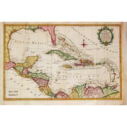
Carte du Golphe du Mexique et des Isles de L'Amerique.
Uncommon edition of this fine map of the Gulf of Mexico. With French text in title cartouche and an additional title in Dutch underneath the map.FromAtlas Portatif pour s...
Date: Amsterdam, 1773
Selling price: ????
Please login to see price!
Sold
![Tête d'un guerrier de la Nouvelle Zélande. [Tome III Pl. 12.]](/uploads/cache/26094-250x250.jpg)
Tête d'un guerrier de la Nouvelle Zélande. [Tome III Pl. 12.]
Portrait of a Maori warrior. From the French edition of James Cook's first voyage entitled Relation des voyages entrepris par ordre de sa Majesté Britannique actuellemen...
Date: Paris, 1773
Selling price: ????
Please login to see price!
Sold in 2008
![Vue de la Baye de Matavaï à Otahiti appellée Havre du Port - Royal par le Capitaine Wallis. [Tome II Pl. 9.]](/uploads/cache/26100-250x250.jpg)
Vue de la Baye de Matavaï à Otahiti appellée Havre du Port - Royal par le Capitaine Wallis. [Tome II Pl. 9.]
View of the Matavaï Bay in Tahiti, named The Haven of the Royal Port by Captain WallisFrom the French edition of James Cook's first voyage entitled Relation des voyages ...
Date: Paris, 1773
Selling price: ????
Please login to see price!
Sold in 2016
![Espève de Massue des Habitants de la Nouvelle Zélande appellées Patous-patous vus de côté du tranchant et du bout. Ils ont de 14 à 18 ouces de long. [Tome III Pl. 15.]](/uploads/cache/26101-250x250.jpg)
Espève de Massue des Habitants de la Nouvelle Zélande appellées Patous-patous vus de côté du tranchant et du bout. Ils ont de 14 à 18 ouces de long. [Tome III Pl. 15.]
Decorated bludgeons. From the French edition of James Cook's first voyage entitled Relation des voyages entrepris par ordre de sa Majesté Britannique actuellement régna...
Date: Paris, 1773
Selling price: ????
Please login to see price!
Sold in 2016
![Pirogue de guerre de la Nouvelle Zélande. [Tome III Pl. 14.]](/uploads/cache/26107-250x250.jpg)
Pirogue de guerre de la Nouvelle Zélande. [Tome III Pl. 14.]
A warrior dugout from New Zealand rowing along the coast. From the French edition of James Cook's first voyage entitled Relation des voyages entrepris par ordre de sa Maj...
Date: Paris, 1773
Selling price: ????
Please login to see price!
Sold in 2008
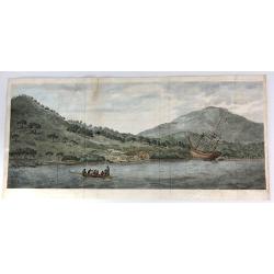
A View of the Endeavour River, on the coast of New Holland ...
The first known landscape drawing of the east coast of Australia. A view of the Endeavour River, on the coast of New Holland, where the ship was laid on shore, in order t...
Date: London, 1773
Selling price: ????
Please login to see price!
Sold in 2016
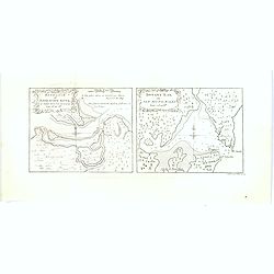
Entrance of Endeavour River / Botany Bay in new South Wales.
A scarce pair of very early nautical charts of Botany Bay and the mouth of the Endeavour River in the newly discovered colony of New South Wales. The charts are based on ...
Date: London, 1773
Selling price: ????
Please login to see price!
Sold in 2017
![[A set of 6 Astronomical copperplate engravings].](/uploads/cache/45926-250x250.jpg)
[A set of 6 Astronomical copperplate engravings].
A set of 6 engravings by J. Mynde from "Ferguson's "Astronomy Explained upon Sir Isaac Newton's Principles. ."[Plate 1] 'The Solar System'.[Plate 2] 'The T...
Date: London, ca 1773
Selling price: ????
Please login to see price!
Sold in 2020

Globus Terrestris ad Sphaeram Obliquam Delineatus / Globus Coelestis cum Astrodictico Artificiali Iunctus.
Hand colored engraving showing terrestrial and celestial globes.
Date: Augsburg, 1774
Selling price: ????
Please login to see price!
Sold in 2008
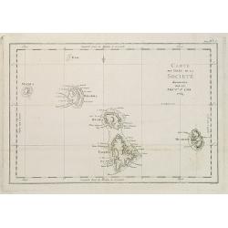
Carte des Isles de la Societé découvertes par le Lieut.t J. Cook 1769.
Map of the islands of Maurua, Bolabola, Otaha, Ulietéa and Huaheine. In upper right corner "Tome III Pl. 1". As James Cook writes in his journal on page 39 : &...
Date: Paris, 1774
Selling price: ????
Please login to see price!
Sold in 2014
![Carte et vues de l'Isle Pitcairn. [Tome I Pl. 9.]](/uploads/cache/25894-250x250.jpg)
Carte et vues de l'Isle Pitcairn. [Tome I Pl. 9.]
Map of the Island of Pitcairn with four profile views. This map is taken from the first French edition of James Cook's first voyage entitled Relation des voyages entrepri...
Date: Paris, 1774
Selling price: ????
Please login to see price!
Sold in 2012
![N.elle Irlande. [Tome I Pl. 12.]](/uploads/cache/25896-250x250.jpg)
N.elle Irlande. [Tome I Pl. 12.]
Chart of New Ireland. New Ireland is a large island in Papua New Guinea. It is the main and largest island of the New Ireland Province. It lies northeast of the island of...
Date: Paris, 1774
Selling price: ????
Please login to see price!
Sold in 2020
![Carte des Découvertes du Capne Carteret dans la Nle Bretagne. . . . [Tome I Pl. 13.]](/uploads/cache/25897-250x250.jpg)
Carte des Découvertes du Capne Carteret dans la Nle Bretagne. . . . [Tome I Pl. 13.]
An attractive map showing partial outlines of Papua New Guinea and New Britain, the largest island in the Bismarck Archipelago northwest of New Guinea. This map is taken ...
Date: Paris, 1774
Selling price: ????
Please login to see price!
Sold in 2009
![Trois vues des Isles de L'Amirauté. . . [Tome I Pl. 14.]](/uploads/cache/25898-250x250.jpg)
Trois vues des Isles de L'Amirauté. . . [Tome I Pl. 14.]
Coastline profiles of the Admiralty Islands. This map is taken from the first French edition of James Cook's first voyage entitled Relation des voyages entrepris par ordr...
Date: Paris, 1774
Selling price: ????
Please login to see price!
Sold in 2020
![Isle de Sir Charles Saunder. . . / Isle Osnabrug. . . / Isle de l'Amiral Keppel. . . / Isle de Wallis. . . [Tome II Pl. 3.]](/uploads/cache/25901-250x250.jpg)
Isle de Sir Charles Saunder. . . / Isle Osnabrug. . . / Isle de l'Amiral Keppel. . . / Isle de Wallis. . . [Tome II Pl. 3.]
Coastline charts of the Admiralty Islands, near New Guinea. This map is taken from the first French edition of James Cook's first voyage entitled Relation des voyages ent...
Date: Paris, 1774
Selling price: ????
Please login to see price!
Sold in 2014
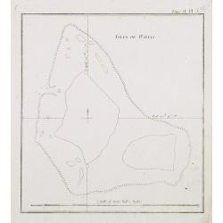
Isles de Wallis. Tome II Pl. 25.
Chart of the Wallis Islands. Willis Island is an island in an external territory of Australia, located beyond the Great Barrier Reef in the Coral Sea some 420 km east of ...
Date: Paris, 1774
Selling price: ????
Please login to see price!
Sold in 2013
![Quadrupede nommé Kanguroo, trouvé sur la Côte de la Nle. Hollande. [Tome IV Pl. 2.]](/uploads/cache/26109-250x250.jpg)
Quadrupede nommé Kanguroo, trouvé sur la Côte de la Nle. Hollande. [Tome IV Pl. 2.]
Attractive and early print of a Kangaroo, engraved from an oil painting by George Stubbs, a famous 18th century artist working in London, who used as a model a skin broug...
Date: Paris, 1774
Selling price: ????
Please login to see price!
Sold in 2008
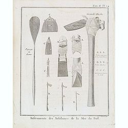
Tome II. Pl. 14 - Instruments des Insulaires de la Mer du Sud.
Taken from the first French edition of James Cook's first voyage entitled Relation des voyages entrepris par ordre de sa Majesté Britannique actuellement régnante pour...
Date: Paris, 1774
Selling price: ????
Please login to see price!
Sold in 2018
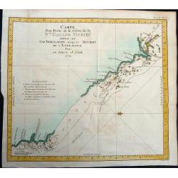
Carte d'une Partie de la Côte, de la Nle Galles Meridle depuis le Cap Tribulation jusqu'au Detroit de l'Endeavour par le Lieut. J. Cook 1770.
Map of a part of the New Galles Meridle Coastline in Australia from the Cap Tribulation to the Endeavour Detroit. This map is taken from the first French edition of James...
Date: Paris, 1774
Selling price: ????
Please login to see price!
Sold in 2021
![[Carte Réduite Des Îles Antilles..] & [Carte Réduite Des Debouquements De St. Domingue..]](/uploads/cache/23048-250x250.jpg)
[Carte Réduite Des Îles Antilles..] & [Carte Réduite Des Debouquements De St. Domingue..]
A well engraved and highly detailed two-in-one chart of the Lesser Antilles (from the eastern tip of Puerto Rico to St. Vincent and Barbados) and of the Turks and Caicos ...
Date: Paris, 1775
Selling price: ????
Please login to see price!
Sold
The Caribbee Islands, The Virgin islands, and the Isle of Porto Rico. . .
Engraved nautical chart showing rhumb lines, shoals, anchorages, etc. Relief shown pictorially, depths by soundings. Covers area south to Barbados. The nautical informati...
Date: London, Sayer and Bennett, 1775
Selling price: ????
Please login to see price!
Sold in 2012
The Windward Passage, with the several passages, from the east end of Cuba, and the north part of St. Domingo.
Engraved nautical chart showing tracks, rhumb lines, etc. Covers part of the Bahamas and the Turks and Caicos Islands. A partial compass roses anchor the bottom of the ch...
Date: London, Sayer and Bennett, 1775
Selling price: ????
Please login to see price!
Sold in 2012

Quadrupede nomme Kanguroo, trouve sur la Cote de la Nouvelle Hollande.
An illustration from the French publication of John Hawkesworth’s "Account of the Voyages undertaken…for making discoveries in the Southern Hemisphere" (Lon...
Date: Paris, ca 1775
Selling price: ????
Please login to see price!
Sold in 2020
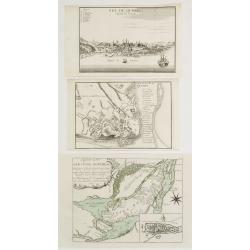
Plan de la Ville de Quebec / Vue De Quebec, Capitale du Canada / Karte von der Insel Montreal..
3 engravings illustrating plans and views of two cities belonging to the French speaking part of Canada.1 Detailed plan of the city of Quebec, uncolored. An uncommon issu...
Date: Paris / Nurnberg 1694-1776
Selling price: ????
Please login to see price!
Sold
Charte von einem Theile des Süd=Meeres. . .
Showing the Pacific, with the track of the English vessel Delphin under Comodor Byron, and Tamar by Captain Mouat, in 1765. The Delphin by Captain Wallis and the Swallow ...
Date: Berlin, 1776
Selling price: ????
Please login to see price!
Sold in 2013

The death of General Wolfe.
This original copper engraving is from "The Death of General Wolfe", famous 1770 painting by the Anglo-American artist Benjamin West. It depicts the death of Br...
Date: London, 1776
Selling price: ????
Please login to see price!
Sold in 2014
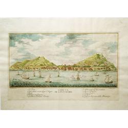
Veduta di S. Eustachio
This is a rare view of St. Eustatius (Statia) in the Dutch West Indies, which had the distinction of being the first foreign nation to officially recognize the newly form...
Date: Italy, 1777
Selling price: ????
Please login to see price!
Sold in 2012
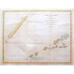
Chart of Discoveries made in the South Pacific Ocean...
An interesting copper-engraved sea-chart of Captain Cook's exploration of New Caledonia and the islands of Vanuatu in 1774. Tracks the route of the ship Resolution betwee...
Date: London, 1777
Selling price: ????
Please login to see price!
Sold in 2016
Kaart van de Golf van Mexico, de Eilanden en de Aangrenzende Landschappen.
A map of the Caribbean from the Dutch edition of Robertson''s "History of America".
Date: Amsterdam, 1778
Selling price: ????
Please login to see price!
Sold in 2019
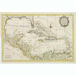
Carte du Golfe du Mexique des isles et des pays adjacens . . .
Detailed map of Caribbean. The map was prepared by William Roberts (1721-1793) in 1777 for the English edition, in 1778 the first French edition followed, L'Histoire de L...
Date: Paris, Panckoucke, 1778
Selling price: ????
Please login to see price!
Sold in 2011

A Jew Rabbi or King Uzziah
An important mezzotint print by William Pether after a 1635 painting by Rembrandt. While some have identified the sitter simply as a Rabbi, others have linked him to King...
Date: London, 1778
Selling price: ????
Please login to see price!
Sold in 2015
Carte des Deux Regions Polaires Jusqu'au 45.e Degre de Latitude.
Interesting map of the poles showing numerous tracks of explorers, including Tasman, Furneaux, Halley, Marion, and the 1773 expedition of Cook. There is an unusual and ut...
Date: Paris, 1778
Selling price: ????
Please login to see price!
Sold in 2018
Plan du Port et Ville de Louisbourg levé en 1756...
French chartof Louisbourg in 1756.Made under the direction of M. de Sartine. Relief shown by hachures. Depths shown by soundings. Below title, engraved seal of Depot Gene...
Date: Paris, 1779
Selling price: ????
Please login to see price!
Sold in 2015
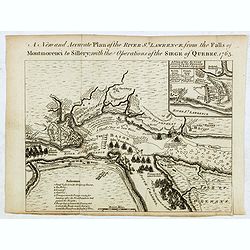
New and Accurate Plan of the River St. Lawrence, from the Falls of Montmorenci to Sillery, with the Operations of the Siege of Quebec 1763
Plan of the siege of Quebec, published in Published in: "The General History of the Late War", first published in 1766, and also in 1775 and 1779 and in "T...
Date: London / Manchester, 1762 - 1779
Selling price: ????
Please login to see price!
Sold in 2016
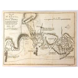
Plan of St. Lucia in the West Indies
A detailed plan by Thomas Bowen of the battle between the English and French forces in St. Lucia during the Revolutionary War. It illustrates the various attacks, and cou...
Date: London, 1779
Selling price: ????
Please login to see price!
Sold in 2016

Globe Terrestre / Globe Celeste.
An attractive and inexpensive late eighteenth century copperplate engraving showing a terrestrial and celestial globe on their fine rings and bases, as engraved for Middl...
Date: London 1779
Selling price: ????
Please login to see price!
Sold in 2020
Carte d'une partie de l'Amérique pour la navigation des isles et du Golfe du Mexique.
A stunning and very scarce, highly detailed map of the Gulf of Mexico, Florida, Central America and the Caribbean from JA Dezauche, the successor to Buache and De L'Isle....
Date: Paris, 1780
Selling price: ????
Please login to see price!
Sold in 2020
![[Prospect der Strasse gegen der Kirche der Recolecten in der obern Stadt zu Quebec. Vuë de la Rue des Recolets dans la haute Ville de Quebec ]](/uploads/cache/31160-250x250.jpg)
[Prospect der Strasse gegen der Kirche der Recolecten in der obern Stadt zu Quebec. Vuë de la Rue des Recolets dans la haute Ville de Quebec ]
A so-called optical print showing a decorative imaginary of Québec, with a street view with soldiers marching, and pedestrians, an idealized view depicting Québec as a...
Date: Augsburg, ca. 1780
Selling price: ????
Please login to see price!
Sold in 2011
![[Prospect des Haupt Plazes der Untern Stadt zu Quebec. ]](/uploads/cache/31161-250x250.jpg)
[Prospect des Haupt Plazes der Untern Stadt zu Quebec. ]
A so-called optical print showing a decorative imaginary town-view of Québec, with a street view with soldiers marching, and pedestrians, an idealized view depicting Qu�...
Date: Augsburg, ca.1780
Selling price: ????
Please login to see price!
Sold in 2011
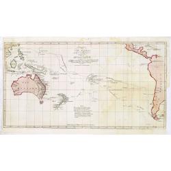
Carte des declinaisons et inclinaisons de L'aiguille aimantee redigee d'apres la table des observations magnetiques faites par les voyageurs depuis l'annee 1775
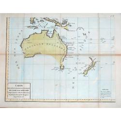
Map of Australasia with imaginary line joining coastline of Australia and New Guinea.Plate No. 6 of an 8 sheet map which was probably compiled from the reports of La Pero...
Date: Paris, ca. 1780
Selling price: ????
Please login to see price!
Sold in 2012

Vue de la Rue des Recolets dans la haute Ville de Quebec - Prospect der Strasse, gegen der Kirche der Recolecten in der obern Stadt zu Quebec.
Curious optical print of Quebec, showing a street scene with soldiers and pedestrians. 'In considering the fictitious views of Canada, made up wholly from the imagination...
Date: Augsburg, c1780
Selling price: ????
Please login to see price!
Sold in 2014
Plan du Typa ou de Macao, Plan de la Baye D'Awatska, Partie du Japon.
A pleasing copper engraving with separate detailed maps of Kamchatka, part of Japan, and the Island of Macao. The Kamchatka map includes an inset: “Plan du Havre de St....
Date: Paris, 1780
Selling price: ????
Please login to see price!
Sold in 2018
Carte des Isles Antilles dans L\'Amérique Septentrionale avec la majeure partie des Isles Lucayes..
Rare Revolutionary War chart of the the tip of South Florida and the Caribbean, prepared to illustrate a part of the Theatre of War between the English and Americans. Wit...
Date: Paris, 1782
Selling price: ????
Please login to see price!
Sold in 2008
West Indies agreeable to the most approved Maps and Charts .
This highly detailed map shows the Colonial possessions in the West Indies. It covers from Florida, with its southern tip made up of several large islands, through the Ba...
Date: London, 1782
Selling price: ????
Please login to see price!
Sold in 2016
Carte des Isles Antilles dans L'Amerique Septentrionale avec la majeure partie des Isles Lucayes . . . Theatre de la Guerre entre les Anglais et les Americains . . .
Rare Revolutionary War chart of South Florida and the Caribbean, prepared to illustrate a part of the Theatre of War between the English and Americans. With decorative ti...
Date: Paris, Esnauts & Rapilly, 1782
Selling price: ????
Please login to see price!
Sold in 2016
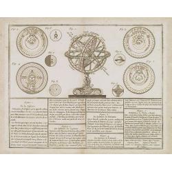
De la Sphère..
Rare print of armillary sphere, surrounded by several diagrams of the sun, moon, and planets after Cassini. In lower part 9 blocks of text with explanations. From Atlas G...
Date: Paris, 1783
Selling price: ????
Please login to see price!
Sold in 2008
Golfe du Mexique Assujetti aux Observations Astronomiques Par J.B.Nolin.
Rare map of the Caribbean prepared by J.B.Nolin and published by Monhare for his Atlas Général a l'usage des colleges et maisons d'education.. Florida is filled with a ...
Date: Paris, 1783
Selling price: ????
Please login to see price!
Sold
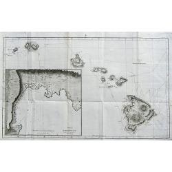
Chart of the Sandwich Islands.
A large chart showing the tracks of Captain James Cook through the Hawaiian islands. Names Owyhee, Mowee, Morotoi, Ranai, Woahoo, Atooi and Oneeheow. Large inset of Karak...
Date: Dublin, ca 1784
Selling price: ????
Please login to see price!
Sold in 2020
