Browse Listings in Catch All
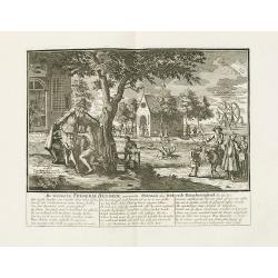
De verreeze Frederik Hendrik ouwerwets patroon der verkeerde barmhertigheid. . .
The title translates into English as following : "Frederick Henry arisen, the ancient patron of ill-placed commiseration, etc".Underneath the print text in Dutc...
Date: Amsterdam, 1720
Selling price: ????
Please login to see price!
Sold
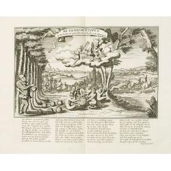
De lachende Ezopus op het koolmaal..
The title translates into English as following : "The laughing Aesop, present at the cole, or cabbage-feast, which was given at the leave-taking of the stock-apes.&q...
Date: Amsterdam, 1720
Selling price: ????
Please login to see price!
Sold
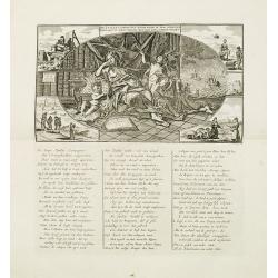
De Zuid Zé Compagnie door wind in top gerezen beklaagt nu haar verlies met een bekommerd wezen.
Decorative print with Dutch title and verso, the title translates as follows: "The South Sea Company, having risen to the top by wind, now laments her loss with a ru...
Date: Amsterdam, 1720
Selling price: ????
Please login to see price!
Sold
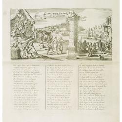
De Viaantsche tol-poort voor d'actionisten komende uyt alle steeden.
The title translates in English as follows : "The tollgate of Vianen for the shareholders arriving from all towns". Decorative !A caricature in prose and verse ...
Date: Amsterdam, 1720
Selling price: ????
Please login to see price!
Sold
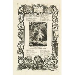
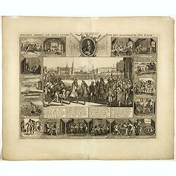
Nieuw-jaars geschenk, met narren paarde muskus geparfumeerd opgedraagen aan de geld-godin Pecunia door de actie-prins of viceroy van Plutus, in zyn niewe schuilhoek zyn wanhebbelyke liefde koesterende.
Page taken from "Het groote tafereel der dwaasheid : vertoonende de opkomst, voortgang en ondergang der actie, bubbel en windnegotie, in Vrankryk, Engeland, en de Ne...
Date: Amsterdam, 1720
Selling price: ????
Please login to see price!
Sold in 2012
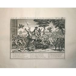
Law, als een tweede Don Quichot, op Sanches Graauwtje..
This engraving is from the important account of one the most infamous financial meltdowns in history, known as the Mississippi Bubble incident. This engraved view is titl...
Date: Amsterdam, 1720
Selling price: ????
Please login to see price!
Sold in 2012
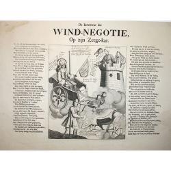
Wind-Negotie, op zijn Zeegekar.
This engraving is from the important account of one the most infamous financial meltdowns in history, known as the Mississippi Bubble incident. This engraved view is titl...
Date: Amsterdam, 1720
Selling price: ????
Please login to see price!
Sold in 2012
De Actiewereld op haar einde.
This engraving is from the important account of one the most infamous financial meltdowns in history, known as the Mississippi Bubble incident. This engraved view is titl...
Date: Amsterdam, 1720
Selling price: ????
Please login to see price!
Sold in 2012
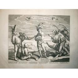
De windverkopers of Windvangers, die door wind, verliezen Geld. . .
Decorative print satirizing the stock exchange business after it collapse in the beginning of the 18th century, that led to the complete ruin of many of over-eager French...
Date: Amsterdam, 1720
Selling price: ????
Please login to see price!
Sold in 2017
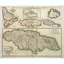
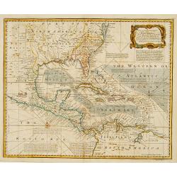
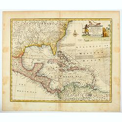
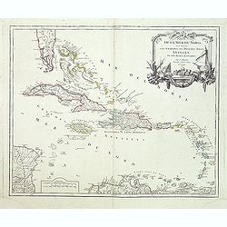
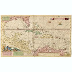
A new map of the English Empire in the Ocean of america or West Indies.
This fine English map of the islands Jamaica, Bermuda, Barbados, Antigua, St.Christopher, Tobago and a inset map of the Caribbean in top.John Senex's A New General Atlas ...
Date: London, 1720
Selling price: ????
Please login to see price!
Sold in 2018
Opkomts, midden, en geen eynde van den doortrapte Jan Lauw.
Print published in : Het groote tafereel der dwaasheid : vertoonende de opkomst, voortgang en ondergang der actie, bubbel en windnegotie, in Vrankryk, Engeland, en de Ned...
Date: Amsterdam, 1720
Selling price: ????
Please login to see price!
Sold in 2017
![[ Bombario Auctionist ] Verhens-Beker van Fi ane of Vianen 2de Tooneel van de Geest van Esopus.](/uploads/cache/39815-250x250.jpg)
[ Bombario Auctionist ] Verhens-Beker van Fi ane of Vianen 2de Tooneel van de Geest van Esopus.
Decorative print of an Bombario Auctionist. A caricature in prose and verse satirizing the first truly international speculative crisis in the history of financial capita...
Date: Amsterdam, 1720
Selling price: ????
Please login to see price!
Sold in 2017
![[ Bombario Auctionist ] Oorsprong rondom bedekte Blaaskaak.](/uploads/cache/39816-250x250.jpg)
[ Bombario Auctionist ] Oorsprong rondom bedekte Blaaskaak.
Decorative print of an Bombario Auctionist. A caricature in prose and verse satirizing the first truly international speculative crisis in the history of financial capita...
Date: Amsterdam, 1720
Selling price: ????
Please login to see price!
Sold in 2017
![[ Bombario Auctionist ] Rector Magnificus van de Ongeactioneerde Litteratuur.](/uploads/cache/39817-250x250.jpg)
[ Bombario Auctionist ] Rector Magnificus van de Ongeactioneerde Litteratuur.
Decorative print of an Bombario Auctionist. A caricature in prose and verse satirizing the first truly international speculative crisis in the history of financial capita...
Date: Amsterdam, 1720
Selling price: ????
Please login to see price!
Sold in 2017
A New Map of Germany, Hungary, Transilvania & the Suisse Cantons,...
Large map of the German Empire, from Belgium until Belgrade, and from Danzig until Lyon. With some notes of local products, for example beer in Hamburg and salt made in T...
Date: London, ca. 1720
Selling price: ????
Please login to see price!
Sold in 2019
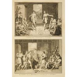
Ceremonie nuptiale du Canada / Maniere dont les peuples du canada font le divorce.
Two prints on one page depicting wedding and divorce customs in Canada.
Date: Amsterdam, 1723
Selling price: ????
Please login to see price!
Sold in 2011
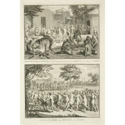
Rejouïssances des peuples du Canada, pendant que l'on porte le défunt ... / Convoi funêbre ...
Two prints on one page depicting funeral customs and celebrations in Canada.
Date: Amsterdam, 1723
Selling price: ????
Please login to see price!
Sold in 2011
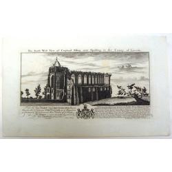
The South East View of Croyland Abbey Near Spalding, in the County of Lincoln.
A fine copper engraving by the Buck Brothers for The Right Honorable John Lord Brownlowe. These are the rmains of an abbey that was founded in the year 716. Samuel and ...
Date: London, 1724
Selling price: ????
Please login to see price!
Sold in 2013
'T EYLANT AMSTERDAM.
Map of the southeastern coast of Tasmania (150x162), centered on Storm bay which was bound to become Hobart's harbor. 4 sites are identified through a key index on the bo...
Date: Amsterdam 1726
Selling price: ????
Please login to see price!
Sold
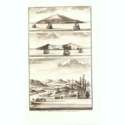
Het Eyland Amsterdam / Het Eyland St. Paulo / Swartte Swaane drift op het Eyland Rottenest.
The lower engraving showing two sailing ships and two long boats preparing to row up the Swan River, and the island discovered by the skipper de Vlamingh of the Dutch Eas...
Date: Amsterdam, 1726
Selling price: ????
Please login to see price!
Sold in 2015
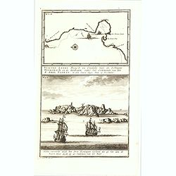
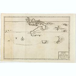
Staeten Landt Bezylt en Ontdekt met de Scheepen Heemskerk en de Zeehaen onder het Commande van den E. Abel Tasman. In den Iaare 1642. Den 13 December.
In the upper part an early map of Staten Landt (110x173mm.)One of the earliest separate depictions of Staten Landt published in François Valentyn's "Oud en nieuw Oo...
Date: Amsterdam, 1726
Selling price: ????
Please login to see price!
Sold in 2015
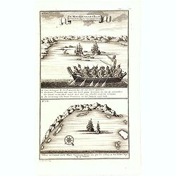
De Moordenaars Baay. Vertoont zich Aldus als gy daer in op 15 vadem ten anker legt. / Aldus vertoont zich Abel Tasmans Baay, als ghy 'er aldus in ten Anker legt op 33 Vadem.
In the lower part Abel Tasman's Bay (110x173mm.). Signed in plate, LL, 'F. Ottens. Fecit. Direxit.' insc".François Valentijn (1666-1727), a missionary, worked at Am...
Date: Amsterdam, 1726
Selling price: ????
Please login to see price!
Sold in 2015
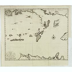
Kaart van de Zuyd-Ooster Eylanden van Banda.
Map of the Banda islands. In the lower part of the map early out lines of Australia showing the northern tip of Arnhem Land, the Arafura Sea, the south-west coast of !New...
Date: Amsterdam, 1726
Selling price: ????
Please login to see price!
Sold in 2015
Kaart der Reyse van Abel Tasman volgens syn eygen opstel..
Rare and important map from Vol III, 2 of Valentyn’s Oud en Nieuw Oost Indien [1726] detailing the discoveries of Abel Tasman in Australasia during the course of his tw...
Date: Amsterdam, 1726
Selling price: ????
Please login to see price!
Sold in 2015
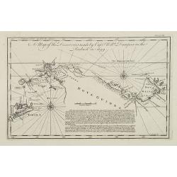
Aldus vertoond de kust van Nova Guinea . . .
Six engravings on one sheet showing coastal views of New Ireland. Dutch (V.O.C.) sailing ships in the foreground.François Valentijn (1666-1727), a missionary, worked at ...
Date: Amsterdam, 1726
Selling price: ????
Please login to see price!
Sold in 2019
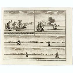
Volkeren van Nova Guinea , en hun Vaertuygen Het Brandende Eyland als het Noord West van u is De Kust van Nova Guinea beoosten het Eyland Jamma De Kust van Jamma nae Moa.
Four engravings on one sheet showing a native New Guinea boat with fishermen and coastal views of New Guinea with Dutch V.O.C. ships in the foreground.François Valentijn...
Date: Amsterdam, 1726
Selling price: ????
Please login to see price!
Sold in 2017
Aldus vertoonen zich de Eylanden Marken, . . .
Four engravings on one sheet showing panoramic views of the islands of Marken, the Groene islands, Sint Jans island and New Ireland, on the same latitude as Cabo de Santa...
Date: Amsterdam, 1726
Selling price: ????
Please login to see price!
Sold in 2016
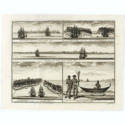
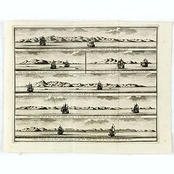
Het Eylandt Takel als gy, daar by Langhs Seylt . . .
Five engravings on one sheet showing the native boats and peoples and coastal views of islands near New Guinea. Dutch (V.O.C.) sailing ships and various local craft fill ...
Date: Amsterdam, 1726
Selling price: ????
Please login to see price!
Sold in 2018
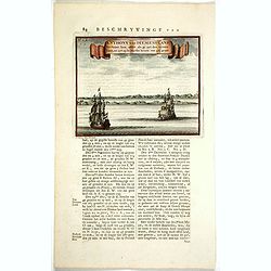
Anthony van DiemensLand. Vertoont hem aldus als gy uyt den westen komt, en zyt op de Zuyder breete van 42 1/2 graad.
One of the earliest depictions of the coast line of Tasmania. Two Dutch vessels off shore. With Dutch letter press on both side giving a description of Tasmania and "...
Date: Amsterdam, 1726
Selling price: ????
Please login to see price!
Sold in 2017
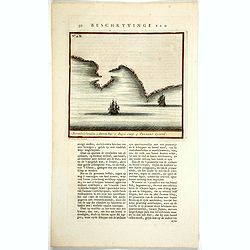
Beschryvinge van ... (N°.2.B) 1. Boreels Eylanden . 2 Storm bay. 3. Zuyd Caep. 4.Tasmans Eyland.
One of the earliest maps of Tasmania. Two Dutch vessels off shore. With a numbered key : 1. Boreels Eylanden . 2 Storm bay. 3. Zuyd Caep. 4.Tasmans Eyland.With Dutch lett...
Date: Amsterdam, 1726
Selling price: ????
Please login to see price!
Sold in 2017
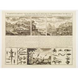
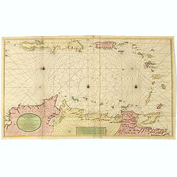
Particularitez Curieuses de l'Ile de St. Christophle et de la Province de Bemarine..
Six meticulously detailed and engraved scenes of the island of St. Kitts, also known as Saint Christopher, and the province of Bemarin,on a single sheet from Volume Six o...
Date: Amsterdam 1728
Selling price: ????
Please login to see price!
Sold
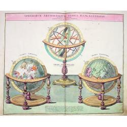
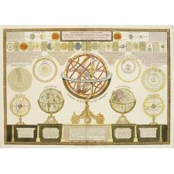
Sphærarum Artificialium Typica Repræsentatio novissime adumbrata.
Rare and decorative sheet, showing celestial and terrestrial globes and an armillary sphere in original colors.
Date: Nuremberg, c1728
Selling price: ????
Please login to see price!
Sold
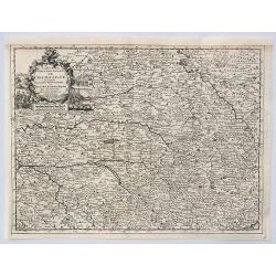
Carte du Gouvernement de Champagne Suivant le Nouvelles Observations . . .
An attractive map of the wine growing region of Champagne in France. It has a decorative cartouche with scenes of trading, country and coastal life. By Van Der AA in Leid...
Date: Leiden, 1729
Selling price: ????
Please login to see price!
Sold in 2020
![[Engraved horizon ring for a 20cm diameter terrestial globe, together with terrestrial and celestial north and south pole calottes.]](/uploads/cache/32257-250x250.jpg)
[Engraved horizon ring for a 20cm diameter terrestial globe, together with terrestrial and celestial north and south pole calottes.]
Engraved horizon ring for a 20cm diameter terrestrial globe, together with terrestrial and celestial north and south pole calottes, engraved by Johann Georg Puschner.The ...
Date: Nuremberg, 1730
Selling price: ????
Please login to see price!
Sold in 2012
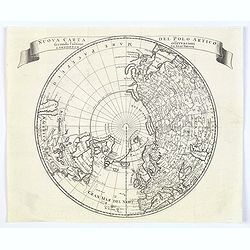
Nuova carta del Polo Artico secondo l'ultime osservazioni ..
From an Italian edition of Solmon's work of this attractive map of a north polar projection.CALIFORNIA IS SHOWN AS AN ISLAND and the Pacific region is completely blank. G...
Date: Rome, 1730
Selling price: ????
Please login to see price!
Sold in 2020
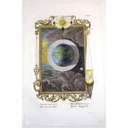
Opus Quartae Diei.
Striking copper engraved print depicting the fourth day of creation. Features the Eastern hemisphere in the print and the sun in the very ornate frame. engraved by I.A. F...
Date: Augsburg, 1731
Selling price: ????
Please login to see price!
Sold in 2014
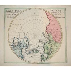
Facies Poli Artici adiacentiumque ei regionum ex recentissimis itirnerariis delineata cura Christophori Weigelii, Norib
An uncommon polar chart that labels present-day northwestern America AMERICA SEPTENTRIONALIA INCOGNITA does not show a western coast. There is good detail of the northern...
Date: ca 1734
Selling price: ????
Please login to see price!
Sold
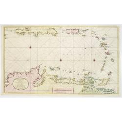
Nieuwe Paskaart van de Kusten van West Indien van Rio Oronoque tot Cartegena Met alle de Caribische Eylanden. . .
A superb large sea chart focusing on the eastern part of the Caribbean Sea, by J. Van Keulen after Jean Bertrand. The engraver was J.B. Stemmers. Printed on two sheets, j...
Date: Amsterdam, ca 1734
Selling price: ????
Please login to see price!
Sold in 2021
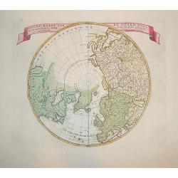
Nieuwe Kaart van de Noord Pool.
A first state example. Highly attractive map of northern polar projection. The Pacific region is completely blank, with good detail in Europe and Asia. In China, the grea...
Date: Amsterdam 1735
Selling price: ????
Please login to see price!
Sold in 2009
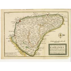
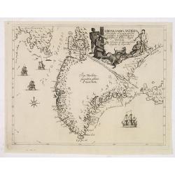
A New Map of the Island of Barbadoes, Containg all ye Parishes..
Small appealing map of the island of Barbados, very detailed showing roads, paths, villages, settlements and more.Barbados is in the Lesser Antilles off the coast of Vene...
Date: London 1736
Selling price: ????
Please login to see price!
Sold
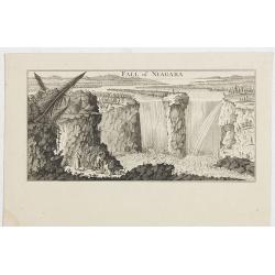
Fall of Niagara.
View of Niagara Falls, taken from the six sheet Dutch edition of Popple's monumental map the British Empire in America .
Date: Amsterdam, 1737
Selling price: ????
Please login to see price!
Sold in 2021
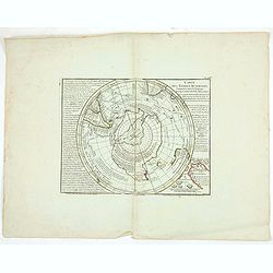
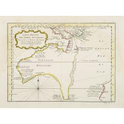
Carte des Terres Australes.
Important map of the South Pole. Shows Australia, Tasmania and New Zealand according to Tasman. No land at the pole. The map is a hemisphere within a rectangular frame.
Date: Paris, 1739
Selling price: ????
Please login to see price!
Sold in 2020
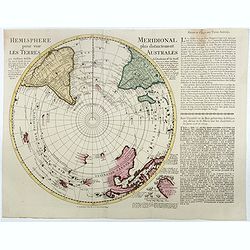
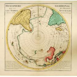
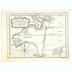
Hemisphere meridional pour voir plus distinctement les terres australes. . .
A Rare Ottens map of the Southern Hemisphere, with an additional text panel pasted to the right side of the map. With the imprint of the Ottens family - rare. The map inc...
Date: Amsterdam, 1740
Selling price: ????
Please login to see price!
Sold in 2016
Gronlandia antiqua secundum utramque partem Orientalem & Occidentalem . . .
A rare map of Greenland showing the southern part of Greenland, Davis Strait, and part of Baffin Island, including Cape Dyer. Decorative elements include ships and Inuits...
Date: Copenhagen, Johan Cristoph Groth, 1741
Selling price: ????
Please login to see price!
Sold in 2014
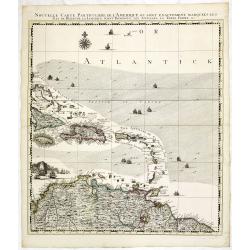
Nouvelle Carte Particuliere de l\'Amerique ou sont Exactement Marquees les Iles de Bermude, la Iamaique, Saint Domingue, les Antilles la Terre Ferme. . .
The lower right maps, with its own border title, of the four sheet Dutch edition of Popple's monumental map of North America.It covers the region from Bermuda through the...
Date: Amsterdam, 1741
Selling price: ????
Please login to see price!
Sold in 2013
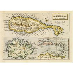
The Island of St. Christophers / Antego Island / Part of y Islands of America &c..
Composite map of St. Christopher, Antigua, and part of the West Indies (from eastern Cuba to northern South America). The St. Kitts and Antigua maps include many place na...
Date: London 1744
Selling price: ????
Please login to see price!
Sold
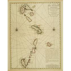
Carte des Antilles Francoises et des Isles Voisines..
Superb detailed map of the Lesser Antilles from Guadeloupe to Grenada, prepared by De L'Isle and reissued by Covens & Mortier.The map is from a Dutch edition of De L'...
Date: Amsterdam c. 1745
Selling price: ????
Please login to see price!
Sold
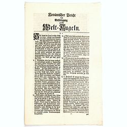
Homannischer Bericht von Berfertigung grosser Welt-Kugeln.
Homannian report of the production of large globes, a small four page, sixteen point document detailing the production for making large globes.
Date: Nuremberg, 1745
Selling price: ????
Please login to see price!
Sold in 2020
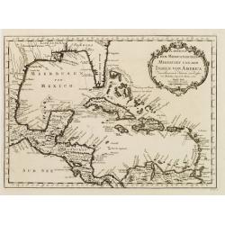
Karte von dem Mexicanischen Meerbusen und dem Inseln von America..
Fine map of the Caribbean, including Florida.Jacques Nicolas Bellin (1703-1772) was one of the most important and proficient French cartographers of the mid-eighteenth ce...
Date: Leipzig, Arkstee & Merkus, 1746
Selling price: ????
Please login to see price!
Sold
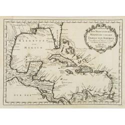
Karte von dem Mexicanischen Meerbusen und dem Inseln von America..
Fine map of the Caribbean, including Florida. From the German edition of Prevost's "L'Histoire Générale des Voyages" by J. J. Schwabe in Leipzig.Jacques Nicol...
Date: Leipzig, Arkstee & Merkus, 1746
Selling price: ????
Please login to see price!
Sold in 2008
![Ins Kleine Gebrachte Karte von den Sud-Laendern zur Histoire der Reisen. [Australia]](/uploads/cache/26065-250x250.jpg)
Ins Kleine Gebrachte Karte von den Sud-Laendern zur Histoire der Reisen. [Australia]
A uncommon map of Australia, one of the few 18th century maps concentrating on the Australian continent. With a reference noting a fictitious visit to south-west New Holl...
Date: Leipzig, Arkstee & Merkus, 1746
Selling price: ????
Please login to see price!
Sold in 2008
A Map of the Discoveries made by Capt.n Will.m Dampier in the Roebuck in 1699.
Uncommon and important map showing the New Britain Island in the Bismarck Sea. The map includes also the Indonesian island of Timor and surrounding islands, Irian Jaya an...
Date: London, 1746
Selling price: ????
Please login to see price!
Sold in 2009
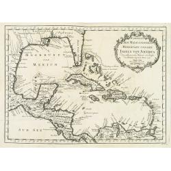
Karte von dem Mexicanischen Meerbusen und dem Inseln von America..
Fine map of the Caribbean, including Florida. From the German edition of Prevost's "L'Histoire Générale des Voyages" by J. J. Schwabe in Leipzig.Jacques Nicol...
Date: Leipzig, Arkstee & Merkus, 1746
Selling price: ????
Please login to see price!
Sold in 2020
An accurate map of the WEST INDIES..
An excellent early engraving of the West Indies and including American east cost till Baltimore. Georgia occupies a very small area next to a large Florida. Numerous plac...
Date: London 1747
Selling price: ????
Please login to see price!
Sold
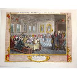
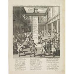
The Industrious Apprentice Grown Rich & Sheriff of London.
Fine large, copper engraved, hand-colored print featuring the industrious apprentice as the Sheriff of London. William Hogarth (1697 – 1764) was an English painter, p...
Date: London, 1747
Selling price: ????
Please login to see price!
Sold in 2013
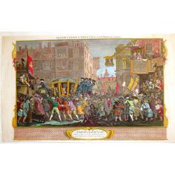
The Industrious Apprentice - Lord-Mayor of London.
Fine, large, hand-colored copper engraving featuring the industrious apprentice riding in a carriage in London. William Hogarth (1697 – 1764) was an English painter, ...
Date: London, 1747
Selling price: ????
Please login to see price!
Sold in 2013
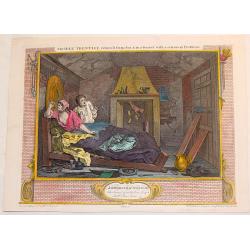
The Idle Apprentice Returned From Dea & in a Garret With a Common Prostitute.
Fine, large, hand-colored, copper engraving featuring the idle apprentice with a prostitute. William Hogarth (1697 – 1764) was an English painter, printmaker, , picto...
Date: London, 1747
Selling price: ????
Please login to see price!
Sold in 2013
An accurate map of the West Indies : drawn from the best authorities, assisted by the most approved modern maps and charts, and regulated by astronomica. . .
An excellent early engraving of the West Indies and including American east cost with Florida, Gulf Coast, Texas, coast till Baltimore, Caribbean and Central America. Geo...
Date: London, 1747
Selling price: ????
Please login to see price!
Sold in 2021
A map of the discoveries made by Captn. Willm. Dampier in the Roebuck in 1699.
This map is of the islands of Timor, New Britain and New Guinea. It appeared in the first volume of John Harris' 'Navigantium atque Itinerantium Bibliotheca. Or, a Comple...
Date: London, T. Woodward, 1744-1748
Selling price: ????
Please login to see price!
Sold in 2011
Introduction a la géographie carte des diverses positions de la sphere. . .
A charming and large print showing a terrestrial, celestial and an armillary globe with smaller circular diagrams illustrating the theories of Ptolemy, Copernicus, Brahe ...
Date: Paris, 1750
Selling price: ????
Please login to see price!
Sold in 2019
Les Murailles de Babylone.
A so-called optical print of the first world wonder, prepared for use in a light-box or an amusing light-show. This richly hand colored print is much perforated, windows ...
Date: Augsburg 1750
Selling price: ????
Please login to see price!
Sold in 2011
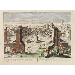
L'Amphitheatre de Rome, sixieme miracle du Monde.
A so-called optical print of the sixth world wonder (Amphi theatre in Rome).In the eighteenth and nineteenth centuries there were many popular speciality establishments i...
Date: Augsburg 1750
Selling price: ????
Please login to see price!
Sold
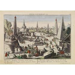
Les Pyramides de l'Egypte, troisieme miracle du Monde.
A so-called optical print of the third world wonder (Pyramids in Egypt).In the eighteenth and nineteenth centuries there were many popular speciality establishments in Pa...
Date: Augsburg 1750
Selling price: ????
Please login to see price!
Sold
Vue de Quebeck.
A so-called optical print showing a decorative view of the town seen from the harbour, with a large vessel in the foreground. Engraved by Balthasar Frederic Leizelt.
Date: Augsburg, 1750
Selling price: ????
Please login to see price!
Sold in 2008
Quebeck.
A so-called optical print showing a decorative imaginary of Québec seen from the harbour, with a large vessel in the foreground. Engraved by Balthasar Frederic Leizelt....
Date: Augsburg, 1750
Selling price: ????
Please login to see price!
Sold in 2016
Partie de la Mer du Nord, ou se trouvent les Grandes et Petites Isles Antilles, et les Isles Lucayes.
The coast of Venezuela from Cartagena to Cumana is also included. The tip of Florida and the Bahamas in the upper left corner. In the right upper corner a decorative titl...
Date: Paris, 1750
Selling price: ????
Please login to see price!
Sold in 2011
Hemisphere Meridional pour voir plus distinctement..
Uncommon edition of a map of the South Pole prepared De l'Isle and re-issued by De Leth brother's. De l'Isle approach was much more scientific than that of his predecesso...
Date: Amsterdam, 1750
Selling price: ????
Please login to see price!
Sold in 2013
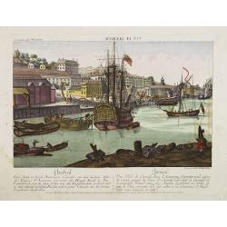
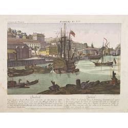
![Vue de la Basse Ville a Quebec gegen St. Laurenz Fluss. [together with] Quebeck.](/uploads/cache/34213-250x250.jpg)
Vue de la Basse Ville a Quebec gegen St. Laurenz Fluss. [together with] Quebeck.
Two so-called optical prints showing a decorative imaginary town-view of Québec seen from the harbour, with a large vessel in the foreground. Engraved by François Xavie...
Date: Augsburg, 1750
Selling price: ????
Please login to see price!
Sold
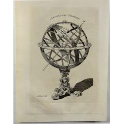
Armillary Sphere.
A fine antique, copperplate print of a celestial armillary sphere, engraved by Thomas Kitchin in 1750. Thomas Kitchin (1718–1784) was an English engraver and cartogra...
Date: London, 1750
Selling price: ????
Please login to see price!
Sold in 2018
Nieuwe en.. West Indien .. Rio Oronoque tot ..Porto Rico..
A highly detailed and rare chart of the coast of Columbia, Venezuela and its islands, Bonaire, Curaçao, Aruba, and several Caribbean Islands, Puerto Rico, Southern coast...
Date: Amsterdam 1751
Selling price: ????
Please login to see price!
Sold
Nouvelle Carte Marine de Toute les Cotes de l´Amerique montrant toutes les isles, Bayes et rivieres, aussi toutes les roches et profonts . . .
Rare chart of Florida, the Gulf Coast, Caribbean and Central America, with great detail through the region, including dangerous rocks, soundings, etc.Florida shows a bit ...
Date: Amsterdam, 1728 - 1751
Selling price: ????
Please login to see price!
Sold
Nieuwe en zeer naauwkeurige paskaart van kusten van West Indien strekkende van Rio Oronoque tot beneede cartagena met alle de Caribische Eylanden. . .
Rare and beautiful sea chart by Van Keulen of the sea offshore of Venezuela and south of Hispanolia, the islands Trinidad, Margarita, Aruba and Curaçao are shown as well...
Date: Amsterdam, ca. 1728-1751
Selling price: ????
Please login to see price!
Sold in 2015
Carte réduite des Terres Australes..
A nice and decorative map showing the pre-Cook outline of Australia, with Van Diemenland still joined to the main island.Part of the coastline of New Zealand appears bott...
Date: Paris 1753
Selling price: ????
Please login to see price!
Sold
Carte réduite des Terres Australes : pour servir a l'Histoire des voyages. . . 1753.
A nice and decorative map of Australia. Van Diemenland still joined to the main island, prepared by J.N.Bellin. Part of the coastline of New Zealand appears bottom right....
Date: London, 1753
Selling price: ????
Please login to see price!
Sold in 2014
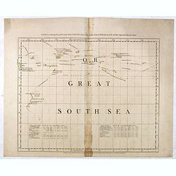
Chart containing the greater part of the South Sea to the south of the line with the islands dispersed thro' the same.
Map has extensive notes and charts noting variations in latitudes and longitudes noted by different observations. Tracks of the ships in the oceans shown along with relev...
Date: London, 1753
Selling price: ????
Please login to see price!
Sold in 2015
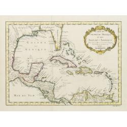
Carte du Golphe du Mexique et des Isles de l'Amerique.
Attractive map of the islands of the Caribbean that includes those parts of the United States & Mexico that border the Gulf of Mexico, Central America, and the northe...
Date: Paris 1754
Selling price: ????
Please login to see price!
Sold
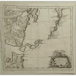
Carte des Isles Kouriles Diapres la Carte Russe. . .
A striking map of Northern Japan and the contiguous islands and coastline. Features a decorative title cartouche. Jacques Nicolas Bellin (1703-1772) was one of the most i...
Date: Paris, 1754
Selling price: ????
Please login to see price!
Sold in 2020
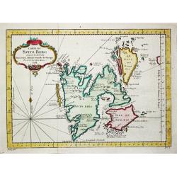
Carte du Spits-Berg.
A map of the island of Spitsbergen where the Dutch had a whaling station in the summer season.Jacques Nicolas Bellin (1702-720) was the most important French hydrographer...
Date: Paris. c. 1755
Selling price: ????
Please login to see price!
Sold in 2018
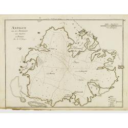
Antigue une des Antilles aux Anglois.
Fine map of Antigua with locations of forts, settlements, and plantations with details of the coastline, anchorages and navigational hazards.George Louis Le Rouge was act...
Date: Paris 1756
Selling price: ????
Please login to see price!
Sold
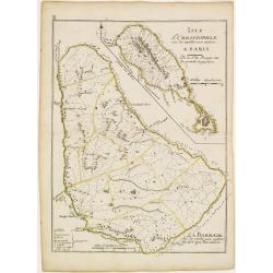
L'Isle St. Christophle.. La Barbade..
Two maps on one sheet showing Barbados and St. Christophers. George Louis Le Rouge was active from 1740- till 1780 as a publisher, and was appointed engineer for the King...
Date: Paris 1756
Selling price: ????
Please login to see price!
Sold
