Browse Listings in Catch All
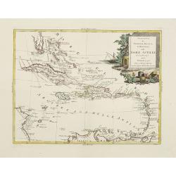
Stabilimenti de Francesi, Inglesi, E Spagnuoli nelle Isole Antille. . .
Scare map of Caribbean, including Florida, Bahamas and coast of Venezuela, including Curacao, Artiba I, Buenayre , etc. Engraved by G.Pitteri.
Date: Venice, 1785
Selling price: ????
Please login to see price!
Sold in 2011
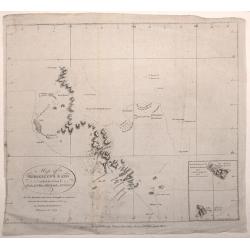
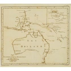
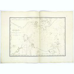
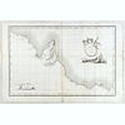
Map of Kerguelen's Land called by Capt. Cook Island of Desolation
A small engraved nautical chart. Relief shown by hachures and pictorially Below the cartouche the inscription: NB. The Shaded Coast is from the English the unshaded fro...
Date: London, 1785
Selling price: ????
Please login to see price!
Sold in 2016
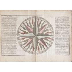
Des Vents (compass rose)
Very decorative compass rose. It includes 32 directional points and many vother details. Note that this is one of the largest compass rose images ever appeared in an atla...
Date: Paris, 1785
Selling price: ????
Please login to see price!
Sold in 2020
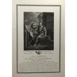
Le Philosophe Democrite (Galerie du Palais Royal).
A fine copper engraving of Democritus,
Date: Paris, 1786
Selling price: ????
Please login to see price!
Sold in 2020
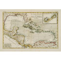
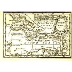
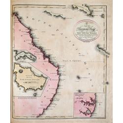
Les Isles Antilles, et le Golfe du Méxique.
An attractive map of the Caribbean with good detail of Central America. Includes the Gulf Coast and Florida with St. Augustine, Pensacola and New Orleans named. A large i...
Date: Paris 1787
Selling price: ????
Please login to see price!
Sold
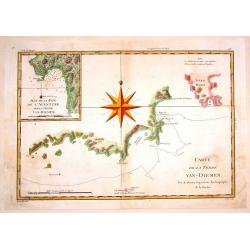
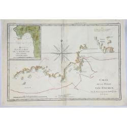
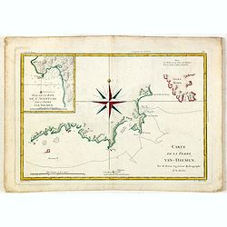
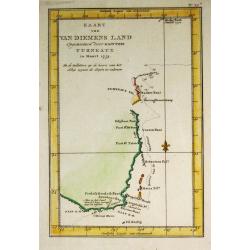
Carte de la Terre Van-Diemen.
Fine, engraved map of part of Tasmania focusing on the coastline surrounding Adventure Bay. Based on Captain James Cook's surveys. Engraved by Andre.Rigobert Bonne (1729-...
Date: Paris, 1787
Selling price: ????
Please login to see price!
Sold in 2015
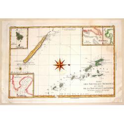
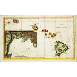
Isles des Nouvelles Hebrides et Celle de la Nouvelle Caledonie.
Fine, engraved map of New Caledonia and Vanuatu, showing the track of Captain James Cook's second voyage. Engraved and signed by Andre. Rigobert Bonne (1729-1795) was “...
Date: Paris, 1787
Selling price: ????
Please login to see price!
Sold in 2015
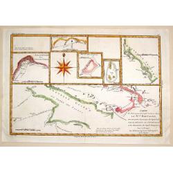
Carte des Decouvertes du Capitane Carteret dans Nouvelle Bretagne.
Fine map of the New Bretagne Islands off the coast of New Guinea with six additionla inserts. Large prominent compass rose and engraved by Andre. BONNE, RIGOBERT (1729-17...
Date: Paris, 1787
Selling price: ????
Please login to see price!
Sold in 2015
Carte de la Terre Van-Diemen.
An unusual 1787 Rigobert Bonne copper engraved map of Tasmania, then called 'Van Dieman's Land'. It includes an inset map of Adventure Bay and shows the route of Captain ...
Date: Paris, 1787
Selling price: ????
Please login to see price!
Sold in 2019
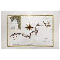
Carte de la Terre VAN DIEMEN.
A fine, engraved map of part of Tasmania focusing on the coastline surrounding Adventure Bay. Based on Captain James Cook's surveys. Engraved by Andre. Rigobert Bonne (17...
Date: Paris, 1787
Selling price: ????
Please login to see price!
Sold in 2020
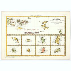
Cartes de Supplement pour les Isles Antilles.
Rigobert Bonne's map of the Virgin Islands and the Antilles Islands (Leeward) in the Caribbean, published in France towards the end of the eighteenth century. Below the m...
Date: Paris, 1787
Selling price: ????
Please login to see price!
Sold in 2020
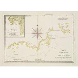
Carte de la Terre Van-Diemen.
Handsome chart of the southern coast of Tasmania with a detailed inset "Plan de la Baye de l'Aventure sur la Terre Van-Diemen." The chart is centered on a large...
Date: Paris 1787-1788
Selling price: ????
Please login to see price!
Sold
![[General map of the North American Caribbean Islands].](/uploads/cache/26128-250x250.jpg)
[General map of the North American Caribbean Islands].
General map of the Caribbean Islands, and part of the South American coast. Scale cartouche on the lower right corner.Sheet 23 of Schraembl's "Allgemeiner Grosser At...
Date: Vienna, 1788
Selling price: ????
Please login to see price!
Sold in 2008
Carte de la Terre Van-Diemen.
Handsome chart of the southern coast of Tasmania with a detailed inset "Plan de la Baye de l'Aventure sur la Terre Van-Diemen." The chart is centered on a large...
Date: Paris, 1787-1788
Selling price: ????
Please login to see price!
Sold in 2018
A chart of the Track of the Alexander on Her Homeward Passage from Port Jackson on the Eastn. Coast of New South Wales to Batavia; Performed in the Year 1788 under the Direction of Lieut. John Shortland by Thomas George Shortland
Shortland was appointed the naval agent to the First Fleet, and it was his responsibility to ensure that the contracts for transport were fulfilled. The Alexander, a 450 ...
Date: London, 1788
Selling price: ????
Please login to see price!
Sold in 2018
Australia, Van Diemen's Land, New South Wales, Queensland; Bonne / Desmarest - N.lle Galles Merid.le ou Cote Orientale de la Nouvelle Hollande . . .
Five maps in one sheet, showing coasts and natural ports of Australia. Folded as issued.
Date: Paris, 1788
Selling price: ????
Please login to see price!
Sold in 2020
Polynesien (Inselwelt) oder der Fünfte Welttheil Verfasst von Herrn Djurberg. . .
One of the first maps to use the name Ulimaroa, originally published in Sweden in 1780. In the first state, it was the first map to use the Maori term Ulimaroa for Austra...
Date: Vienna, Schraembl, 1789
Selling price: ????
Please login to see price!
Sold in 2008
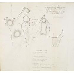
Sketch of Sydney Cove, Port Jackson in the County of Cumberland, New South Wales, July 1788.
Shows Sydney Cove with soundings and seven of the First Fleet ships at anchor: Sirius as guard ship at the mouth of the cove. It shows the positions of temporary and perm...
Date: London, 1789
Selling price: ????
Please login to see price!
Sold in 2010
Polynesien (Inselwelt) oder der Fünfte Welttheil Verfasst von Herrn Djurberg. . .
One of the first maps to use the name Ulimaroa, originally published in Sweden in 1780. In the first state, it was the first map to use the Maori term Ulimaroa for Austra...
Date: Vienna, Philipp Josef Schalbacher, 1789
Selling price: ????
Please login to see price!
Sold in 2013
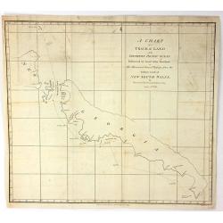
A chart of a track of land in the Southern Pacific Ocean Discovered by Lieut. John Shortland...
The full title is: A chart of a track of land in the Southern Pacific Ocean Discovered by Lieut. John Shortland on His Homeward Bound Passage from the Eastern Coast of Ne...
Date: London, 1789
Selling price: ????
Please login to see price!
Sold in 2018
A chart of the Track of the Scarborough, on Her Homeward Passage, from Port Jackson, on the E. Coast of New South Wales, towards China; by Captain John Marshall
A copper engraved chart showing the track of the 'Scarborough' back to China via China in 1789. The Scarborough was one of the ships of the First Fleet, which brought the...
Date: London, 1789
Selling price: ????
Please login to see price!
Sold in 2016
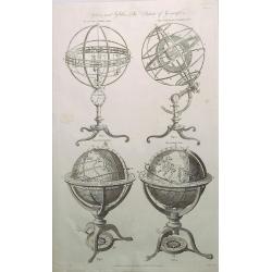
Spheres and Globes - System of Geography.
A detailed chart with four globes including Copernican, Armillary Sphere, Newly Improved Armillary Sphere, Terrestrial Globe and Celestial Globe. The print was published ...
Date: London, 1789
Selling price: ????
Please login to see price!
Sold in 2020
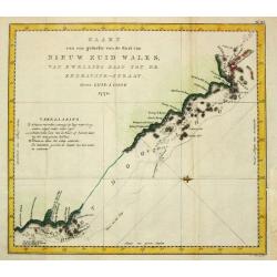
Kaart van Nieuw Zuid Wales of de oostlijke kust van Nieuw Holland.
Dutch edition of this map by Cook, who was the first published full-scale map of the east coast of Australia as charted by Cook in the Endeavour in 1770. All names are tr...
Date: Haarlem c.1790
Selling price: ????
Please login to see price!
Sold
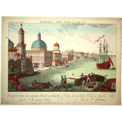
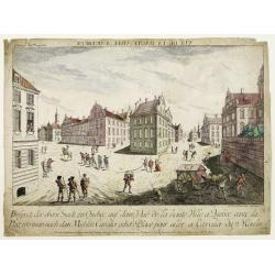
Vue de la Basse Ville a Quebec vers le Fleuve St. Laurent.
A lovely view of the river and city of Quebec with a ship and boat in the foreground. Engraved for a Vue d'Optique, it was designed to be viewed in a special apparatus th...
Date: Augsburg, ca.1790
Selling price: ????
Please login to see price!
Sold in 2008
Karte des Mexicanischen Meerbusens und der anstofsenden Inseln und Laender..
Fine map of the Crribbean. Included in the uncommon German text edition of Campens travels.Engraved by Knittel.
Date: Reutlingen, c.1790
Selling price: ????
Please login to see price!
Sold
Vue de la Haute ville a Quebec..
A beautiful view of square at the road to the Millbarracks in Quebec with soldiers in the foreground. Engraved for a Vue d'Optique, it was designed to be viewed in a spec...
Date: Augsburg 1790
Selling price: ????
Please login to see price!
Sold in 2008
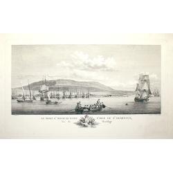
Le Mole St Nicolas dans l'Isle de St Domingue, Vu du Mouillage
Drawn by Nicolas Ozanne and engraved by Jeanne F. Ozanne.
Date: Paris, c.1790
Selling price: ????
Please login to see price!
Sold in 2008
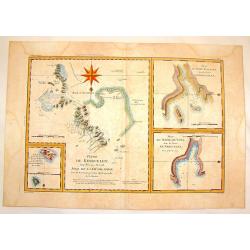
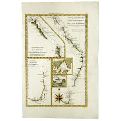
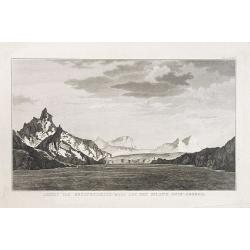
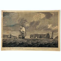
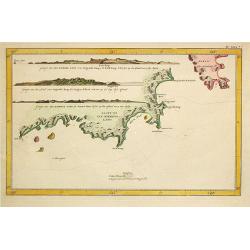
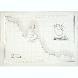
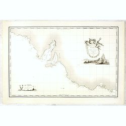
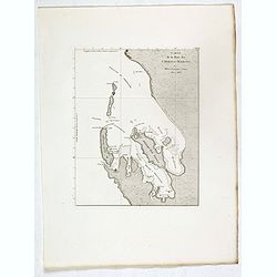
Terre de Kerguelen Appellee par M. Cook, Isle de la Desolation.
Interesting copper engraved map of the Kerguelen Islands including Plan du Havre de Noel, & Plan du Port Palliser.BONNE, RIGOBERT (1729-1795). Bonne was “Royal Hydr...
Date: Paris, 1790
Selling price: ????
Please login to see price!
Sold in 2015
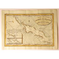
Nouvelle Carte Reduite, l'Archipel des Arsacides.
Interesting map of New Guinee, also called “Archipel des Iles de Salomon” from “Descouvertes des Francois au Sud-Est de la Nouvelle Guinee”. It was published in ...
Date: Paris, 1790
Selling price: ????
Please login to see price!
Sold in 2019
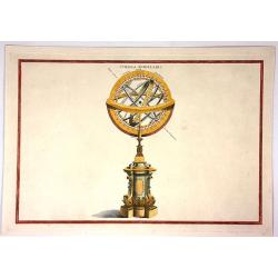
Sphaera Armillaris.
Fine example of a Ptolemaic armillary sphere. The central terrestrial globe (labeled Terra) is surrounded by Arctic and Antarctic circles, Cancer and Capricorn tropical c...
Date: London, ca. 1790
Selling price: ????
Please login to see price!
Sold in 2019
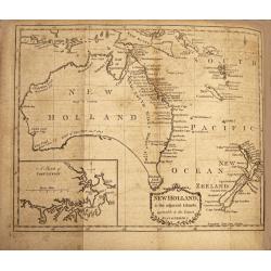
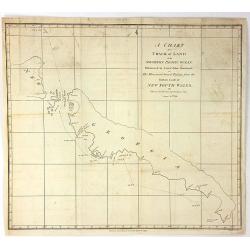
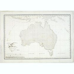
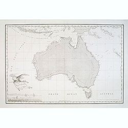
New Holland & the Adjacent Islands , Agreeable to the Latest Discoveries.
A very fine, rare, important map with an inset map of 'A Sketch of Port Jackson'. A very detailed period map of what is now called Australia, with the southern portion co...
Date: Edinburgh,1790
Selling price: ????
Please login to see price!
Sold in 2019
West Indies.
Uncommon miniature map from Gibson's "Atlas Minimus, or a New Set of Pocket Maps of the several Empires, Kingdoms and States of the known World".
Date: London, 1792
Selling price: ????
Please login to see price!
Sold in 2011
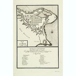
Le plan de Louisbourg dans l'Isle Royale au Canada : Les Anglais tentoient sans succe`s de l'emparer de cette forteresse le 7 Septembre 1757, le 26 Juillet en 1758 elle se rend aux Anglais.
The plan depicts Louisbourg at the time of its capture by the English in 1758. The individual structures are listed in a numeric legend. The plan is from L.Therbu's: &quo...
Date: Frnkfurt am Main, 1792
Selling price: ????
Please login to see price!
Sold in 2012
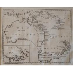
New Holland & the adjacent Islands , agreeable to the Latest Discoveries.
A very fine, rare, important antique 1792 copperplate map with an inset map of 'A Sketch of Port Jackson'. A very detailed period map of what is now called Australia, wit...
Date: London, 1792
Selling price: ????
Please login to see price!
Sold in 2018
![[10 sheets] Globo Terrestre [and] Globo Celeste.](/uploads/cache/46380-250x250.jpg)
[10 sheets] Globo Terrestre [and] Globo Celeste.
A fine set of hand colored gore sheets for a pair of Cassini 30 cm globes extracted from the Nuovo Atlante Geografico Universale, published from 1790-1801.Cassini's gores...
Date: Rome, 1790-1792
Selling price: ????
Please login to see price!
Sold in 2020
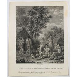
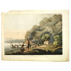
A Family of Charaibes, drawn from the Life, in the Island of St. Vincent.
A lovely and charming engraving of a family, eating, drinking and relaxing on the Caribbean island of St. Vincent. A dwelling is shown, together with local dress, neck be...
Date: London, 1793
Selling price: ????
Please login to see price!
Sold in 2020
LAUF des Transport-Schiffes Waaksamheyd von Port Jackson..
Fine map of Australia with inset of Norfolk Island. Showing the track from Port Jackson in New South Wales to Batavia, of the vessel Waaksamheyd. Engraved by C.F.Gürsch.
Date: Hamburg 1794
Selling price: ????
Please login to see price!
Sold
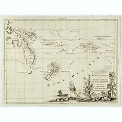
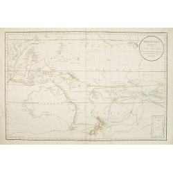
Nuova Guinea e Nuova Galles ed Isole Adjacenti
Map of the South Pacific, showing the sailing routes to the South Pacific by Carteret and Byron, but most importantly, the discoveries made by Captain Cook, 1768-1771. Th...
Date: Venise, 1794
Selling price: ????
Please login to see price!
Sold in 2015
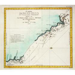
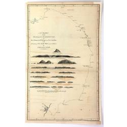
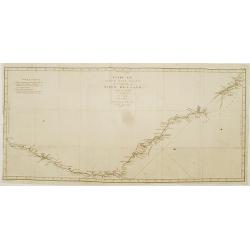
Carte d'une Partie de la Côte de la N.le galles Merid.le depuis le Cap Tribulation jusqu'au Détroit de l' Endeavour. 1770.
A chart of the northeast coast of Australia after Captain James Cook (1728-79), explorer, circumnavigator and hydrographer. Three voyages, 1768-71, 1772-75 and 1776-79. F...
Date: Paris, c. 1795
Selling price: ????
Please login to see price!
Sold
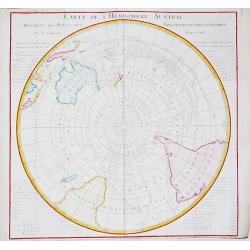
Carte de l' Hemisphere Austral.
Captain James Cook (1728-79), explorer, circumnavigator and hydrographer. Three voyages, 1768-71, 1772-75 and 1776-79. From 1778 on printed editions of ' Captain Cook's T...
Date: Paris, c. 1795
Selling price: ????
Please login to see price!
Sold in 2016
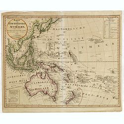
Karte vom Funften Erdtheil oder Polynaesien ..Australien..
Prepared by Friedrich Canzler. Australia called Ulimaroa , often used at that time as it was the term Cook learned from the New Zealand Maoris. Including Indonesia, Taiwa...
Date: Nuremberg, 1795
Selling price: ????
Please login to see price!
Sold in 2015
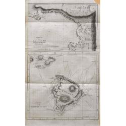
Chart of the Sandwich Islands.
Scarce map of the Hawaiian Islands featuring the large island of Owhyhee, Mowee [Maui], Tahroorowa, and Ranai. Shows the time-dated sea-track of James Cook from November ...
Date: London, ca. 1795
Selling price: ????
Please login to see price!
Sold in 2015
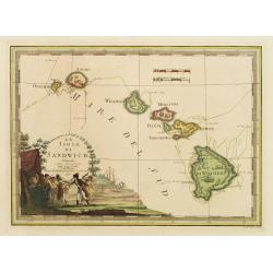
Le Isole di Sandwich..
Scare map of Hawaii. Embellished with a decorative cartouche imaginatively illustrating the death of Captain Cook on the island of Hawaii in 1779. The map itself is quite...
Date: Rome 1798
Selling price: ????
Please login to see price!
Sold
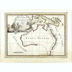
La Nuova Olanda e La Nuova Guinea delineate sulle ultima osservazioni.
Cassini’s splendid and rare map of Australia and New Guinea, from the 'Nuovo Atlante Geografico Universale'. The emphasis of the map is the charting of Captain Cook dow...
Date: Rome, 1798
Selling price: ????
Please login to see price!
Sold in 2018
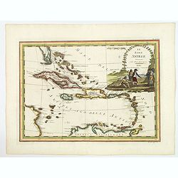
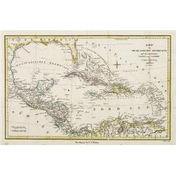
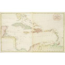
Le Isole Antille Delineate Sulle Ultime Observazioni.
A scare map of Caribbean, that includes the southern tip of Florida, which is shown as an archipelago, the Bahamas, and the northern coast of Venezuela, including Artiba ...
Date: Rome, 1798
Selling price: ????
Please login to see price!
Sold in 2020
GEZIGT VAN BEZITNEEMING-BAAI AAN HET EILAND ZUID-GEORGIE. Pl.LXXI*.
A landscape and sea coast view of the South Georgian mountains.South Georgia is a British overseas territory in the southern Atlantic Ocean. This territory is a remote an...
Date: Amsterdam, ca. 1800
Selling price: ????
Please login to see price!
Sold in 2016
A view of the of the Pierced Island, a remarkable rock in the Gulf of St. Laurence - two leagues to the southward of Gaspée Bay. . .
Print shows a warship in the foreground approaching rock formation in the Gulf of Saint Lawrence. Drawn on the spot by Capt. Hery. Smyth and engraved by Pierre Charles Ca...
Date: London, ca. 1800
Selling price: ????
Please login to see price!
Sold in 2020
A new map of the West Indies.. (2 sheets)
A large scale and detailed map of the West Indies made by Bryan Edwards, a Jamaican planter and politician, for this 1793 publication describing the West Indies. The map ...
Date: London c.1793-1801
Selling price: ????
Please login to see price!
Sold
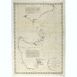
Kaart van Basses Straat, tusschen Nieuw Zuid Wales en Van Diemens-Land ... Heer Flinders ... 1798-1799. . .
A fine chart of Tasmania and the southern part of Australia with the Bass Strait, with the Hunters Islands and the Furneauz Islands, and the southernmost part of the Aust...
Date: Leyden, Amsterdam & The Hague: Honcoop, Allart & van Cleef, 1795-1801
Selling price: ????
Please login to see price!
Sold in 2021
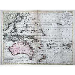
Australien (Südland) auch Polynesien oder Inselwelt. . .
FIRST EDITION of Johann Walch map of Australasia and the South Pacific. Australia still indicated as Neu Holland . Inserted in the map the routes followed by Cook, Byron,...
Date: Augsburg, 1802
Selling price: ????
Please login to see price!
Sold in 2013
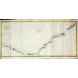
Kaart. . . van de kust van Nieuw Zuid Wales van Kwelling Kaap tot de Endeavour-Straat 1770.
A chart of the northeast coast of Australia from the northern extremity of Cape York peninsula with Endeavour Strait to the Endeavour River and present day Cooktown. From...
Date: Leiden, 1795-1803
Selling price: ????
Please login to see price!
Sold
Kaart van Nieuw Zuid Wales of de Oostlijke Kust van Nieuw Holland ontdekt?.J. Cook? 1770
A map of the east coast of Australia. Captain James Cook (1728-79), explorer, circumnavigator and hydrographer. Three voyages, 1768-71, 1772-75 and 1776-79. From 1778 on ...
Date: Leiden, 1795-1803
Selling price: ????
Please login to see price!
Sold
Kaart van Van Diemens Land.
A map of Tasmania surveyed by Captain James Cook (1728-79), explorer, circumnavigator and hydrographer.
Date: Leiden, 1795-1803
Selling price: ????
Please login to see price!
Sold
Kaart van Van Diemens Land.
A map of the southernmost part of van Diemens Land. After Captain James Cook (1728-79), explorer, circumnavigator and hydrographer. Three voyages, 1768-71, 1772-75 and 17...
Date: Leiden, 1795-1803
Selling price: ????
Please login to see price!
Sold
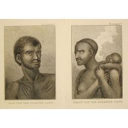
Vrouw / Man van van Diemens Land.
Captain James Cook (1728-79), explorer, circumnavigator and hydrographer. Three voyages, 1768-71, 1772-75 and 1776-79. From 1778 on printed editions of ' Captain Cook's T...
Date: Leiden, 1795-1803
Selling price: ????
Please login to see price!
Sold in 2017
Kaart van Van Diemens Land.
Captain James Cook (1728-79), explorer, circumnavigator and hydrographer. Three voyages, 1768-71, 1772-75 and 1776-79. From 1778 on printed editions of ' Captain Cook's T...
Date: Leiden, 1795-1803
Selling price: ????
Please login to see price!
Sold in 2011
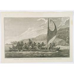
Praauw van de Sandwich's eilanden, met gemaskerde roeijers.
Decorative engraving of a Hawaiian proa, rowed by masked oarman. From a Dutch edition of Cook's voyages'.Captain James Cook (1728-79), explorer, circumnavigator and hydro...
Date: Leiden, 1795-1803
Selling price: ????
Please login to see price!
Sold in 2020
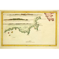
Carte d'une partie de la terre de Witt (à la nouvelle-Hollande) 3ème feuille. . .
Map of the Western Australian coastline from Cape Leveque to Lesueur Island showing tracks of "Le Geographe" in 1801 and 1803 and "Le Casuarina" in 18...
Date: Paris, 1803
Selling price: ????
Please login to see price!
Sold in 2011
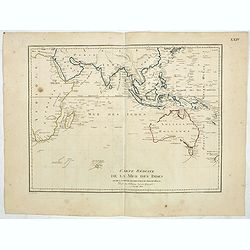
Carte reduite de la Mer des Indes et de la partie occidentale du Grand Océan. (Page XXIV)
Uncommon map of the Indian Ocean, Australia and the East Coast of Asia, showing still an incomplete coastline for Australia and New Guinea, among other features. The map ...
Date: Paris, 1803
Selling price: ????
Please login to see price!
Sold in 2019
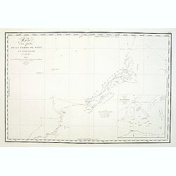
Kaart van de Sandwich eilanden.
A close copy of James Cook's first map of Hawaii. It shows Cook's tracks through the archipelago, including dates, topographical features of the islands and a large inset...
Date: Leiden, 1795-1803
Selling price: ????
Please login to see price!
Sold in 2021
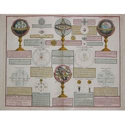
TABLEAU ANALYTIQUE des différentes positions de la Sphère, des diff'rents systèmes, des révolutions et des distances des Planètes, &c.
Charles François Delamarche (1740-1817), Paris-based geographer and publisher, successor to Didier Robert de Vaugondy after his death in 1786.Attractive print with a cel...
Date: Paris, 1804
Selling price: ????
Please login to see price!
Sold
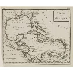
Golfe du Mexique.
Map of Central America, including Greater and Lesser Antilles. From Atlas de la Géographie de toutes les parties du monde .. Ouvrage destiné pour l'education, et néces...
Date: Paris, Prudhomme, Levrault, Debray, 1806
Selling price: ????
Please login to see price!
Sold in 2018
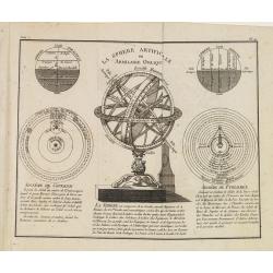
La Sphere Artificielle ou Armilaire Oblique.
At the center of the map an armillary sphere surrounded by the parallel and right sphere, the representation of the Copernican and Ptolemaic system.From Atlas de la Géog...
Date: Paris, Prudhomme, Levrault, Debray, 1806
Selling price: ????
Please login to see price!
Sold in 2013
Plan du Port du Nord-Ouest dans le Canal Dentrecasteaux / Plan du Port de L'Esperance. . .
A French maritime charts of the Plan du Port du Nord-Ouest, and Port Esperance both in southern Tasmania, just south of Hobart. This is the edition of the extremely rare ...
Date: Paris, 1807
Selling price: ????
Please login to see price!
Sold in 2020
Carte Generale de la partie Meridionale de la Nouvelle Hollande. . .Terre D'Anthony van Diemen. . .
A rarely seen map showing, in great detail, an area of Tasmania explored by Admiral Bruny-Dentrescasteaux. The expedition to search for the lost expedition of La Perouse ...
Date: Paris 1807
Selling price: ????
Please login to see price!
Sold in 2019
Carte Particuliere du canal Dentrecasteaux entre la Terre Meridionale d'Anthony van Diemen. . .
A lovely chart of the southeast coast of Tasmania from South Cape to North Bay, which includes the present site of Hobart. These charts are strikingly beautiful & acc...
Date: Paris 1807
Selling price: ????
Please login to see price!
Sold in 2019
Carte Generale du Detroit de Bass. . .
A highly detailed chart of the waters between Victoria on the mainland of Australia and the island of Tasmania, (Bass Strait) published by expedition member Louis Claude ...
Date: Paris 1807
Selling price: ????
Please login to see price!
Sold in 2019
View in Queen charlotte's sound, New Zealand.
Early view of Queen charlotte's sound, taken from "Views in the South Seas" being a very important and early views depicting scenes encountered while employed a...
Date: London, Boydell and Co., 1808
Selling price: ????
Please login to see price!
Sold in 2019
A New and Accurate Map of New South Wales...
Interesting map of eastern Australia, published by Thomas Brown. It includes 3 inset maps of Norfolk Island, Lord Howe Island, and Port Jackson with Botany Bay! Shows als...
Date: Edinburgh, 1801-1808
Selling price: ????
Please login to see price!
Sold in 2014
Carte Generale de la Nouvelle Hollande.
Fine map of the continent of Australia prepared by Louis Freycinet during his voyage under Captain Thomas Baudin in 1800-1803. Freycinet's map of New Holland was the firs...
Date: Paris, 1811
Selling price: ????
Please login to see price!
Sold in 2011
Carte Generale de la Terre Napoleon (a la Nouvelle Hollande)... par M.L. Freycinet an 1808
Fine map of part of Australia prepared by Louis Freycinet during his voyage under Captain Thomas Baudin in 1800-1803. The longitude is calculated from Paris.The cartouche...
Date: Paris, 1811
Selling price: ????
Please login to see price!
Sold in 2011
Carte Generale de la Nouvelle Hollande.
The Freycinet map of Nouvelle Hollande is generally recognized as the first full map of Australia to be published. In historical context the map is the culmination of a l...
Date: Paris, 1811
Selling price: ????
Please login to see price!
Sold in 2012
Carte Generale de la Terre Napoleon (a la Nouvelle Hollande)... par M.L. Freycinet an 1808.
The First Detailed Mapping of the Adelaide Region ( identified as B. Dugueselin, C. Sully and C. Mondovi) and centered on Kangaroo Island (Ile Decres) and extends east to...
Date: Paris, 1811
Selling price: ????
Please login to see price!
Sold in 2015
![Plan d'une partie de la Terre Napoleon (Nouvelle-Hollande) par M. M. H. Freycinet et Bernier, an 1802. [with] Plan des Iles Josephine et de la Baie Murat (a la Terre Napoleon, Nouvelle-Hollande) . . .](/uploads/cache/36244-250x250.jpg)
Plan d'une partie de la Terre Napoleon (Nouvelle-Hollande) par M. M. H. Freycinet et Bernier, an 1802. [with] Plan des Iles Josephine et de la Baie Murat (a la Terre Napoleon, Nouvelle-Hollande) . . .
Two maps showing Descartes Bay and Bridgewater Bay in Victoria and Murat Bay in South Australia showing French discoveries prepared by Louis Freycinet during his voyage u...
Date: Paris, Langois, 1811
Selling price: ????
Please login to see price!
Sold in 2017
Carte Generale de la Terre Napoleon (a la Nouvelle Hollande)... par M.L. Freycinet an 1808
The rare issue of the "L'hydrographie française" with in the upper right corner "HYDR.FR N°636. No10".Important chart of part of Australia prepared ...
Date: Paris, after 1811
Selling price: ????
Please login to see price!
Sold in 2016
Carte de la Baie des Chiens-Marins par M. M. L. Freycinet et Faure, 1801 et 1803.
Map of Shark Bay in Western Australia, showing French discoveries prepared by Louis Freycinet during his voyage under Captain Thomas Baudin in 1800-1803. Plate no. 13 fro...
Date: Paris, Langois, 1811
Selling price: ????
Please login to see price!
Sold in 2017
![Plan des Iles Louis-Napoleon et de la Riviere des Cygnes (Terres de Leuwin et d'Edels) [cartographic material] / par M. M. L. Freycinet et Heirisson, ans 1801 et 1803.](/uploads/cache/39676-250x250.jpg)
Plan des Iles Louis-Napoleon et de la Riviere des Cygnes (Terres de Leuwin et d'Edels) [cartographic material] / par M. M. L. Freycinet et Heirisson, ans 1801 et 1803.
Map of Rottnest Island and the Swan River in Western Australia, showing French discoveries prepared by Louis Freycinet during his voyage under Captain Thomas Baudin in 18...
Date: Paris, Langois, 1811
Selling price: ????
Please login to see price!
Sold in 2017
![Plan de la Baie Laplace . . . [with] Esquisse du Port Western (a la Terre Napoleon, Nle. Hollande) . . .[with] Plan des Iles Forestier (a la Nouvelle-Hollande). . . [with] Esquisse du Port Champagny (a la Terre Napoleon) . . .](/uploads/cache/39677-250x250.jpg)
Plan de la Baie Laplace . . . [with] Esquisse du Port Western (a la Terre Napoleon, Nle. Hollande) . . .[with] Plan des Iles Forestier (a la Nouvelle-Hollande). . . [with] Esquisse du Port Champagny (a la Terre Napoleon) . . .
Four maps showing Tumby Bay and Port Lincoln in South Australia, Western Port in Victoria and Forestier Islands in Western Australia, showing French discoveries prepared ...
Date: Paris, Langois, 1811
Selling price: ????
Please login to see price!
Sold in 2017
![Plan du port du Roi-George, à la terre de Nuyts. . . [with] Plan de la baie du Geographe, à la terre de Leuwin. . .](/uploads/cache/39678-250x250.jpg)
Plan du port du Roi-George, à la terre de Nuyts. . . [with] Plan de la baie du Geographe, à la terre de Leuwin. . .
Two maps of King George Sound, Nuyts Land, showing French discoveries prepared by Louis Freycinet during his voyage under Captain Thomas Baudin in 1800-1803. Plate no. 10...
Date: Paris, Langois, 1811
Selling price: ????
Please login to see price!
Sold in 2017
![Plan des Iles Jerome (Terre Napoleon). . . [with] Plan des Iles Berthier (Terre Napoleon). . . [with] Plan du comte de Cumberland (Nouvelle-Galles du sud) d'apres les cartes Anglaises, mais assujetti aux observations Francaises.](/uploads/cache/39679-250x250.jpg)
Plan des Iles Jerome (Terre Napoleon). . . [with] Plan des Iles Berthier (Terre Napoleon). . . [with] Plan du comte de Cumberland (Nouvelle-Galles du sud) d'apres les cartes Anglaises, mais assujetti aux observations Francaises.
Three maps showing Dorothee Island and Veteran Isles in the Investigator Group and the County of Cumberland in New South Wales, showing French discoveries prepared by Lou...
Date: Paris, Langois, 1811
Selling price: ????
Please login to see price!
Sold in 2017
