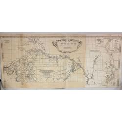
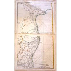
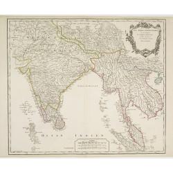
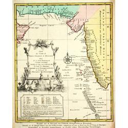
Carte de L'Inde Dressee pour la Compagnie des Indes.
The TOP HALF ONLY of the large format map of 18th century India, published by D'Anville. This map draws from numerous sources, including Ptolemy, Turkish and Indian geogr...
Date: Paris, 1752
Selling price: ????
Please login to see price!
Sold in 2018
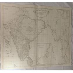
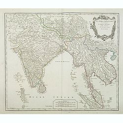
Carte de L'inde Dresse pour la Compagni des Indes. . .
A large map of 18th century India, published by D'Anville in 1752. It reflects the state of knowledge of this area mid-century. The map shows excellent detail of Southern...
Date: Paris, 1752
Selling price: ????
Please login to see price!
Sold in 2019
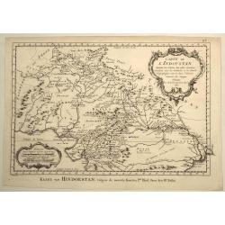
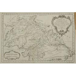
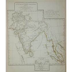
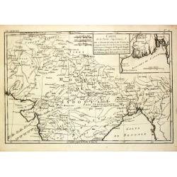
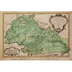
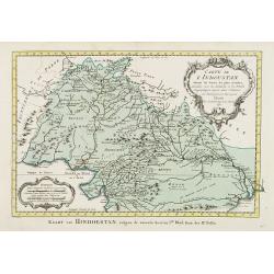
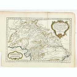
Carte de L'Indoustan Suivant les Cartes les Plus Recentes...
This pleasing map depicts the northern section of the Indian subcontinent and includes present-day Pakistan, Afghanistan, Nepal, and Tibet, in addition to northern India....
Date: Paris, 1752
Selling price: ????
Please login to see price!
Sold in 2021
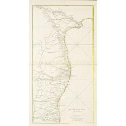
COROMANDEL.
A large map showing the east coast of the Indian peninsular.
Date: Paris, 1753
Selling price: ????
Please login to see price!
Sold in 2022
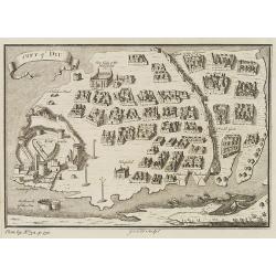
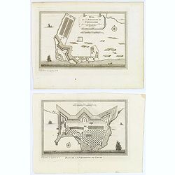
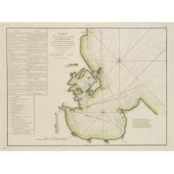
City of DIU.
Decorative town plan of Diu, after Joan Nieuhof. Engraved by G.Child for 'The Universal Traveller', by Thomas Salmon.
Date: London, Th. Salmon, 1729-1753
Selling price: ????
Please login to see price!
Sold in 2010
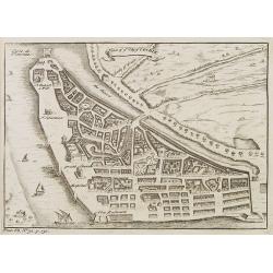
Plan of ye City of Cochin.
A small but very early and interesting town plan of Cochin, engraved by G.Child for 'The Universal Traveler', by Thomas Salmon.
Date: London, Th. Salmon, 1729-1753
Selling price: ????
Please login to see price!
Sold in 2012
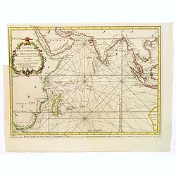
Karte von dem mittaeglichen Meere, zu der allgemeinen Historie der Reise beschreibungen entworfen von Hrn Bellin..
Detailed map of the Indian Ocean depicting incomplete coastline for Western Australia marked with "See hunden Bay" and "I.des Filles". Reaching in the...
Date: Leipzig, 1753
Selling price: ????
Please login to see price!
Sold in 2008
Karte von dem Mittaeglichen Meere zu der allgeinen Historie der Reis-beschreibungen. . .
Atlantic Ocean with coastlines of South America and Africa. In: Allgemeine Historie der Reisen zur Wasser und zu Lande: oder Sammlung aller Reisebeschreibungen.. in Engli...
Date: Leipzig, 1753
Selling price: ????
Please login to see price!
Sold in 2008
Cormandel.
A large map on two sheets showing the east coast of the Indian peninsula. Covers from Narsapur to Nagapatinam. Includes the cities of Medapili, Kistenapatam, Arimegon, an...
Date: Paris, 1753
Selling price: ????
Please login to see price!
Sold in 2016
Suite de la Carte de L'Inde en deca du Gange..
A good engraved map of India with Sri Lanka, with rococo title cartouche lower left. From l'Histoire générale des voyages .
Date: Paris 1754
Selling price: ????
Please login to see price!
Sold
Carte de L'Indoustan ...
From l'Histoire générale des voyages. Prepared by Jacques Nicholas Bellin (1703-1772), one of the most important and proficient French cartographers of the mid-eighteen...
Date: Paris, 1754
Selling price: ????
Please login to see price!
Sold in 2011
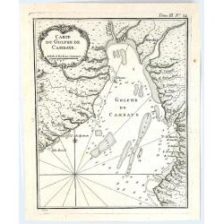
Carte du Golphe de Cambaye.
A quaint little map of India, featuring the Gulf of Cambay (Gulf of Khambhat) India, published in “Le Petit Atlas Martime” published by Bellin in 1764. Featuring a f...
Date: Paris, 1754
Selling price: ????
Please login to see price!
Sold in 2016
Les Indes Orientales, ou sount distingues les Empires et Royaumes..
Interesting regional map extending from India, the Ganges and the Maldive Islands to Hai-nan, Cochinchina, Malacca and Sumatra. Includes islands, towns, mountains, rivers...
Date: Paris 1755
Selling price: ????
Please login to see price!
Sold
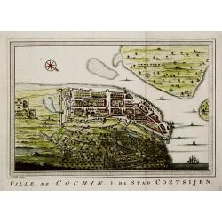
Ville de Cochin / De Stad Coetsijen.
Jaques Nicolas Bellin (1702-720) was the most important French hydrographer of the 18th century. Sea-atlas 'Hydrographique Français' , 1756-65, atlas to accompany Prévo...
Date: Amsterdam, c. 1755
Selling price: ????
Please login to see price!
Sold
Les Indes Orientales, ou sont distingues les Empires et Royaumes. . .
Interesting regional map extending from India, the Ganges and the Maldive Islands to Hai-nan, Cochinchina, Malacca and Sumatra. Includes islands, "Sinca poura" ...
Date: Paris, ca. 1755
Selling price: ????
Please login to see price!
Sold in 2021
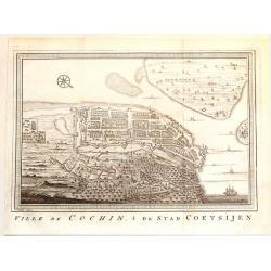
Ville de Cochin de Stad Coestsijen.
Striking copper engraving of Kochi, a major port city on the west coast of India. It has been considered as the center of the Indian spice trade for centuries. It was fir...
Date: Amsterdam, 1755
Selling price: ????
Please login to see price!
Sold in 2018
Carte des cotes de l'Hindoustan depuis Bombay jusqu'à Godavery . . .
A well engraved and highly detailed chart that was prepared by M. Daussy. Engraved by Chassant, engraver for the Depot Générale de la marine is noted as such on the map...
Date: Paris, 1755
Selling price: ????
Please login to see price!
Sold in 2016
Plan de la Forteresse de Coylan / Plan de la Forteresse de Cranganor. . .
The first of a pair of Indian prints is a rare map of the fort of Kollam, Kerala, on India's (east) Malabar Coast by the French cartographer N. Bellin. Kollam, or as it i...
Date: Paris, ca 1756
Selling price: ????
Please login to see price!
Sold in 2019
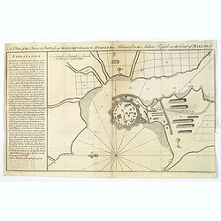
A Plan of the Town & Fortress of Garlah belonging to Angria the Admiral to the Jahou Rajah on the Coast of Mallabar.
A very interesting bird's eye view of the fort and surrounds. Text at left explains the numbers on the chart providing fascinating detail. With rhumb lines, soundings, a ...
Date: London, 1756
Selling price: ????
Please login to see price!
Sold in 2021
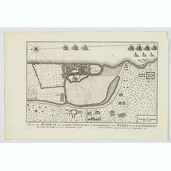
Plan de Madraz et du Fort St. Georges. Pris par les Francois le 21 Septembre 1746 / Grondtekening van Madras en't Fort St. Georges, door de Fransen ingenoomen den 21 September 1746.
A plan of the city of Chennai (then Madras) the capital of Tamil Nadu, in southern India, and the old British Fort of St George (captured during the brief French occupati...
Date: Amsterdam, ca 1756
Selling price: ????
Please login to see price!
Sold in 2021
Les Indes Orientales, ou sount distingues les Empires et Royaumes..
Interesting regional map extending from India, the Ganges and the Maldives Islands to Hai-nan, Cochin china, Malacca and Sumatra. Includes islands, towns, mountains, rive...
Date: Paris, 1757
Selling price: ????
Please login to see price!
Sold in 2011
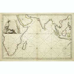
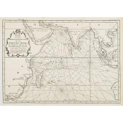
Carte Réduite de l'Océan Oriental ou Mer des Indes.
A of the Indian Ocean, with its islands and adjacent coasts in detail. The chart stretches from the Congo coast, around Africa, Arabia, India and South East Asia, includ...
Date: Paris, 1757
Selling price: ????
Please login to see price!
Sold in 2011
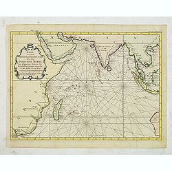
Karte von dem Morgenlaendischen Ocean oder dem Indischen Meere. Zur allgemeinen Historie der Reisebeschreibungen entworfen. . . .
Copper engraving, decorative handcolored in wash and outline. A fine and detailed larger map of the Indian Ocean from Africa towards Southeast Asia and New Holland (Austr...
Date: Leipzig, Merkur, 1758
Selling price: ????
Please login to see price!
Sold in 2013
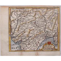
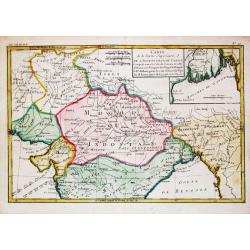
Mogol.
This fine little map shows Northern India and Pakistan including Kabul, Delhi & Gulf of Bengal.
Date: Paris, 1758
Selling price: ????
Please login to see price!
Sold in 2017
Kaart van den Oostersen Oceaan, of Indiese Zee......
Intriguing map of the Indian Ocean, with partial outlines of Australia, South East Asia, India, Arabia and Eastern Africa and Madagascar. With title in French (and Dutch ...
Date: Amsterdam, ca 1758
Selling price: ????
Please login to see price!
Sold in 2016
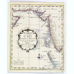
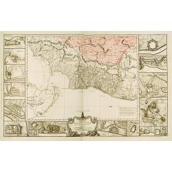
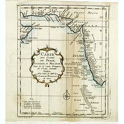
Carte des Costes de Perse Gusarat et Malabar. . .
Detailed copper engraved map of the Persian Gulf and western India, from Perse (Persia), and Grand Mogol in the north, down to the southern tip of India, including the Ma...
Date: Paris, ca. 1758
Selling price: ????
Please login to see price!
Sold in 2018
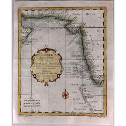
Carte des Costes de Perse, Gusarat et Malabar.
A detailed copper engraved map of the Persian Gulf and western India, from Perse (Persia), and Grand Mogol in the north, down to the southern tip of India, including the ...
Date: Paris, 1758
Selling price: ????
Please login to see price!
Sold in 2017
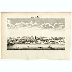
Vue de Goa.
Fine plan of Goa. Goa was made as capital of the Portuguese Vice-Kingdom in Asia, and the other Portuguese possessions in India.
Date: Paris, 1758
Selling price: ????
Please login to see price!
Sold in 2022
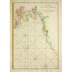
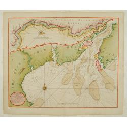
Carte de la Cote Orientale du Golfe de Bengale
A French sea chart from 'Le Depot de la marine", depicting the most-northern part of the Gulf of Bengalen.
Date: Paris, c. 1760
Selling price: ????
Please login to see price!
Sold
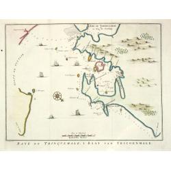
Baye de Trinquemale.
Jan van Schley is the engraver of the maps (by J.N. Bellin) and views in the Dutch edition of A.F. Prévost d' Exile's 'Histoire Géneral des Voyages.A map of Koddiyar Ba...
Date: Amsterdam, c. 1760
Selling price: ????
Please login to see price!
Sold
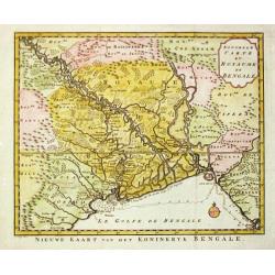
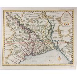
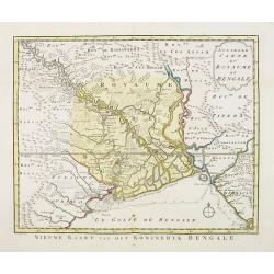
Nouvelle Carte du Royaume de Bengale.
Jaques Nicolas Bellin (1702-720) was the most important French hydrographer of the 18th century. Sea-atlas 'Hydrographique Français' (1756-65) atlas to accompany Prévos...
Date: Amsterdam, c. 1760
Selling price: ????
Please login to see price!
Sold
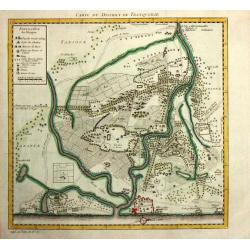
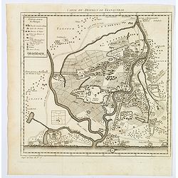
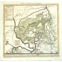
Carte du District de Tranquebar.
A map of Tranqebar and vincinity on the Coromandel coast.Jacques Nicolas Bellin (1702-720) was the most important French hydrographer of the 18th century. Sea-atlas "...
Date: Amsterdam, c. 1760
Selling price: ????
Please login to see price!
Sold in 2018
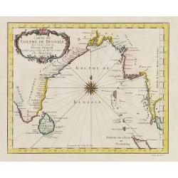
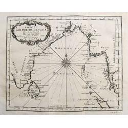
Carte du Golphe de Bengale.
Jaques Nicolas Bellin (1702-720) was the most important French hydrographer of the 18th century. Sea-atlas 'Hydrographique Français' , 1756-65, atlas to accompany Prévo...
Date: Amsterdam, c. 1760
Selling price: ????
Please login to see price!
Sold
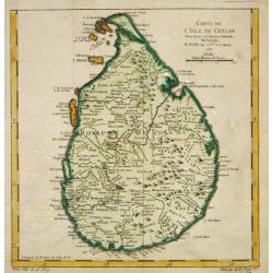
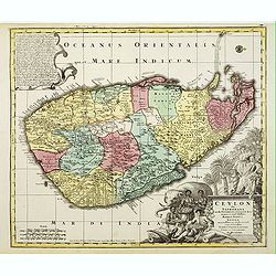
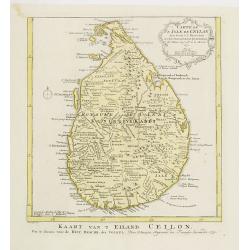
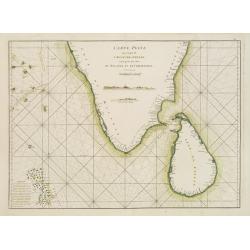
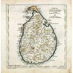
Carte de l?Isle de Ceylan, 1750.
Jaques Nicolas Bellin (1702-720) was the most important French hydrographer of the 18th century. Sea-atlas 'Hydrographique Français' (1756-65) atlas to accompany Prévos...
Date: Paris, c. 1760
Selling price: ????
Please login to see price!
Sold
Carte de l?Isle de Ceylan, 1750.
Jaques Nicolas Bellin (1702-720) was the most important French hydrographer of the 18th century. Sea-atlas 'Hydrographique Français' , 1756-65, atlas to accompany Prévo...
Date: Amsterdam, c. 1760
Selling price: ????
Please login to see price!
Sold
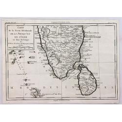
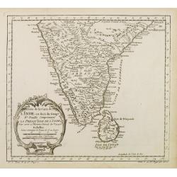
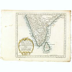
Carte de la Partie Meridionale de la Presqu'ile de l'inde en deca du Gange.
A quaint map of southern India and Ceylon by Brion de la Tour. From Brunet's Histoire Universelle, depuis le commencement du monde jusqu'a present by Brion de la Tour.Lo...
Date: Paris, 1760
Selling price: ????
Please login to see price!
Sold in 2018
Carte du District de Tranquebar.
A lovely detailed map of the area around Tranquebar (now Tharangambadi), on the Coromandel coast. It was an early Danish Trading Colony in the modern Indian state of Tami...
Date: Paris ca 1760
Selling price: ????
Please login to see price!
Sold in 2020
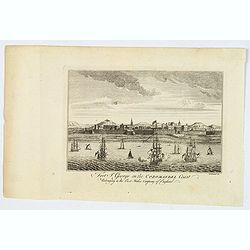
Fort St. George on the Coromandel Coast, Belonging to the East India Company of England.
A fine copperplate engraving of Fort St. George, Madras (Chennai )on the south east coast of India. The fort flies the Union Jack flag, and many sailing vessels are seen ...
Date: London, ca 1760
Selling price: ????
Please login to see price!
Sold in 2019
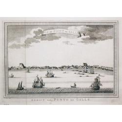
Gezicht van Punto de Galle. Plus 2 other views of the area.
[Antique view of Galle] Gezicht van Punto de Galle. Jan van Schley is the engraver of the maps (by J.N. Bellin) and views in the Dutch edition of A.F. Prévost d' Exile's...
Date: Amsterdam, ca 1760
Selling price: ????
Please login to see price!
Sold in 2020
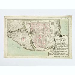
Plan der Stadt und Festung Madrass in Ost-Indien.
Scarce plan of Madras, taken from a collection of battle and siege plans that relate to the 'Seven Years War'. This detailed plan shows off the British Fortress of Madras...
Date: Nuremberg, ca 1762
Selling price: ????
Please login to see price!
Sold in 2018
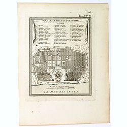
Plan de la Ville de Pondicheri.
A pretty small plan of the south eastern Indian city of Pondicherry. Over the centuries it has been ruled by the French (mostly), the Dutch and the English (occasionally)...
Date: Paris, 1764
Selling price: ????
Please login to see price!
Sold in 2018
![[Lot of 12 maps] INDIA maps+gravures - Carte De La Baye De Trinquemale Dans L’Isle De Ceylon](/uploads/cache/4100003-250x250.jpg)
[Lot of 12 maps] INDIA maps+gravures - Carte De La Baye De Trinquemale Dans L’Isle De Ceylon
[Lot of 12] INDIA maps + gravure - Carte De La Baye De Trinquemale Dans L’Isle De Ceylon.- Platte Grond van t'Fort Tricoen male met de daar aangelegen Pagoods-Berg...
Date: 1764
Selling price: ????
Please login to see price!
Sold in 2023
Ad antiquam Indiae geographiam tabula.
A map showing India with an inset in the lower part entitled Ptolemaicae Tabulae showing the island of Sri Lanka.
Date: Paris, 1765
Selling price: ????
Please login to see price!
Sold in 2011
Neue Karte Von De, Konigreiche Bengala.
A fine Jacques Bellin map of the Nyanmar region of India, featuring the Bay of Bengal.
Date: Paris, 1767
Selling price: ????
Please login to see price!
Sold in 2017
Theatre de la Guerre dans l'Inde sur la Cote de Coromandel Par M.B.C.T.
VERY RARE MAP of southern part of India, running from Madras to Cape Comorin, interestingly a part is marked in red manuscript Etats de Ayder Aly Kan and colored in pink ...
Date: France, 1770
Selling price: ????
Please login to see price!
Sold
Carte de la Partie Superieure de l' Inde en deça du Gange.
Rigobert Bonne (1727-1795), French cartographer. His maps are found in a.o. Atlas Moderne (1762), Raynal's Histoire Philos. du Commerce des Indes (1774) and Atlas Encyclo...
Date: Paris, c. 1770
Selling price: ????
Please login to see price!
Sold
Ceylon olim Taprobana?Maris Indici Insula?
T.C. Lotter married M. Seutter's daughter in 1740 and succeeded him in 1756. Lotter used the copperplate of Seutter, he only changed the name.
Date: Augsbourg, 1770
Selling price: ????
Please login to see price!
Sold
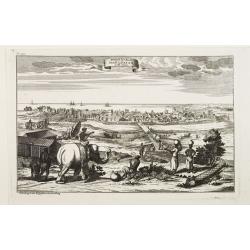
Prospect der Stadt Masulipatam in Ost=Indien.
A rare view of the town of Masulipatam in India. Many locals and elephants in the foreground.
Date: Nurnberg 1770
Selling price: ????
Please login to see price!
Sold
Carte du District de Tranquebar.
A detailed map of Tharangambadi,(Tranquebar & vicinity) an early trading colony controlled by Denmark. It is in the current Indian state of Tamil Nadu on the Coromand...
Date: Amsterdam, 1770
Selling price: ????
Please login to see price!
Sold in 2015
Carte de la Partie Superieure de l' Inde en deça du Gange.
Rigobert Bonne (1727-1795), French cartographer. His maps are found in a.o. Atlas Moderne (1762), Raynal's Histoire Philos. du Commerce des Indes (1774) and Atlas Encyclo...
Date: Paris, c. 1770
Selling price: ????
Please login to see price!
Sold in 2020
Carte du Golphe de Bengale...
Nice chart of the Bay of Bengal. The map extends from Malabar to Sumatra and today Phuket area in Thailand. Including Pegu, Ceylon, and the Andaman and Nicobar Islands. N...
Date: Paris, ca. 1770
Selling price: ????
Please login to see price!
Sold in 2017
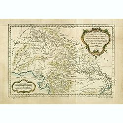
Carte de l' Indoustan...
Nicolas Bellin's map of Pakistan and northern India. Uncommon Dutch issue, with text in French and Dutch. Engraved by J.van Schley. From "Atlas Portatif pour servir ...
Date: The Hague, 1773
Selling price: ????
Please login to see price!
Sold in 2020
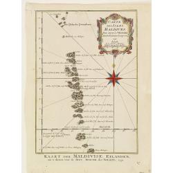
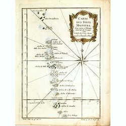
Carte des isles Maldives.
Jaques Nicolas Bellin (1702-720) was the most important French hydrographer of the 18th century. Sea-atlas 'Hydrographique Français' , 1756-65, atlas to accompany Prévo...
Date: Amsterdam, 1773
Selling price: ????
Please login to see price!
Sold
Carte des Costes de Perse, Guzarat et Malabar.
Jaques Nicolas Bellin (1702-720) was the most important French hydrographer of the 18th century. Sea-atlas 'Hydrographique Français' , 1756-65, atlas to accompany Prévo...
Date: Amsterdam, 1773
Selling price: ????
Please login to see price!
Sold in 2018
Carte de L'Indoustan. . .
Uncommon edition of this fine map of the northern part of India. In lower right engraved "4a"From Atlas Portatif pour servir a l'intelligence de l'Histoire Phil...
Date: Amsterdam, 1773
Selling price: ????
Please login to see price!
Sold in 2013
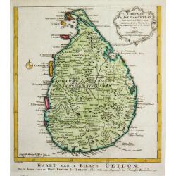
Carte de L'Isle de Ceylan. Pour servir à l'histoire. . .
Uncommon edition of this fine map of Shri Lanka. In lower right engraved "6."From Atlas Portatif pour servir a l'intelligence de l'Histoire Philosophique et Pol...
Date: Amsterdam, 1773
Selling price: ????
Please login to see price!
Sold in 2020
Nouvelle carte du Royaume de Bengale.
Uncommon issue of this detailed map of Bangladesh with the Ganges delta, including Calcutta. Giving great detail with trade routes, European trade settlements, etc.Prepar...
Date: Amsterdam, 1773
Selling price: ????
Please login to see price!
Sold
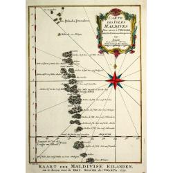
Carte des isles Maldives.
A map of the Maldive Islands. Jacques Nicolas Bellin (1702-720) was the most important French hydrographer of the 18th century. He published a sea-atlas "Hydrographi...
Date: Amsterdam, 1773
Selling price: ????
Please login to see price!
Sold in 2017
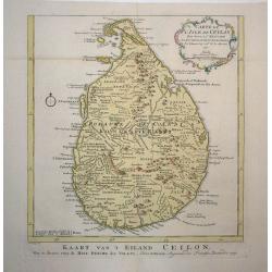
Carte de l'Isle de Ceylan
Detailed copper engraved map of the island with good detail inland of mountains, rivers, towns and villages. Rococo-style cartouche and a simple compass rose accent the m...
Date: Amsterdam, 1773
Selling price: ????
Please login to see price!
Sold in 2009
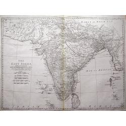
The East Indies including more particularly the British Dominions on the Continent of India...
Very detailed map of India with Ceylon. Extends to include the Maledives, Andaman Islands, Tibet, Pegu, and a tiny part of Sumatra. Engraved by Thomas Kitchin.
Date: London, 1773
Selling price: ????
Please login to see price!
Sold in 2013
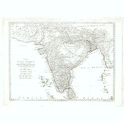
The East Indies . . .
Highly detailed map of India and Sri Lanka, drawn by Thomas Kitchin and published in the London Magazine. Cities, towns and geographical features are all shown.
Date: London, 1773
Selling price: ????
Please login to see price!
Sold in 2018
Carte de la Baye et du Port de Trinquemalay Dans L'Isle de Ceylan.
French chart of the harbour of Trinquemalay on the island of Ceylon. Prepared after Samuel Cornish who was a vice admiral for the English East India company.Latitude and ...
Date: Paris, ca 1775
Selling price: ????
Please login to see price!
Sold
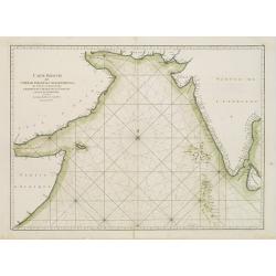
Carte Plate qui comprend l'Isle de Ceylan, une partie des Côtes de Malabar et de Coromandel.
French chart of Ceylon and southern part of India. Latitude and longitude scales, compass rose and system of rhumb lines, soundings near coast and in bay areas.D' Après ...
Date: Paris, ca 1775
Selling price: ????
Please login to see price!
Sold
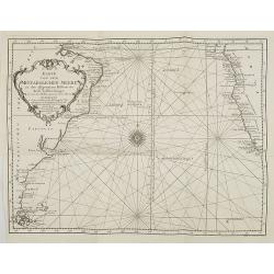
Carte réduite de l'Océan Oriental Septentrional qui contient une partie des Côtes d'Afrique, de l'Arabie, de la Perse et celles de l'Indostan.
French of the coast of Indian ocean with a part of Africa, of Arabia of Persia, of India. Latitude and longitude scales, compass rose and system of rhumb lines, sounding...
Date: Paris, ca 1775
Selling price: ????
Please login to see price!
Sold
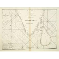
Carte Plate qui comprend L'Isle de Ceylan. . .
Chart showing the southern tip of India and Sri Lanka. Latitude and longitude scales, compass rose and system of rhumb lines, soundings near coast and in bay areas.D' Apr...
Date: Paris, 1775
Selling price: ????
Please login to see price!
Sold in 2021
Carte de l'inde en deça du gange comprenant l'Indoustan.
An interesting map of Hindustan and the River Ganges .Prepared by Jacques Nicolas Bellin after Dutch sources and included in Prévost d' Exile's "Histoire des Voyage...
Date: Paris, 1738-1775
Selling price: ????
Please login to see price!
Sold in 2020
Carte de l'Inde en deça du Gange comprenant l'Indoustan.
An interesting map of Hindustan and the River Ganges.Prepared by Jacques Nicolas Bellin after Dutch sources and included in Prévost d' Exile's "Histoire des Voyages...
Date: Paris, 1738-1775
Selling price: ????
Please login to see price!
Sold in 2020
Carte des Isles Maldives, pour servir à l'Histoire Générale des Voyages.
An interesting map of all the islands of the Maldives.Prepared by Jacques Nicolas Bellin after Dutch sources and included in Prévost d' Exile's "Histoire des Voyage...
Date: Paris, 1738-1775
Selling price: ????
Please login to see price!
Sold in 2014
Carte de l'Isle de Ceylan, pour servir à l'Histoire Générale des Voyages.
An interesting map of the island of Ceylon which is now known as Sri Lanka, includes rivers mountains forests and symbols for small towns and cities .Prepared by Jacques ...
Date: Paris, 1738-1775
Selling price: ????
Please login to see price!
Sold in 2014
Carte des Costes de Perse, Gusarat, et Malabar.
An interesting map of the coasts of the Persian Gulf, Iran, Pakistan and Western India including the Maldives Islands .Prepared by Jacques Nicolas Bellin after Dutch sour...
Date: Paris, 1738-1775
Selling price: ????
Please login to see price!
Sold in 2022
Carte de l'inde en deça du gange comprenant la presqu'iIle de l'Inde.
An interesting map of the peninsula of India with Ceylon.Prepared by Jacques Nicolas Bellin after Dutch sources and included in Prévost d' Exile's "Histoire des Voy...
Date: Paris, 1738-1775
Selling price: ????
Please login to see price!
Sold in 2017
A new & Correct Chart shewing.. Bay of Bengalen..
Important chart of the Bay of Bengal. In upper part inset map of river Ganges. From East India Pilot . Detailed map with compass roses and system of rhumb lines, sounding...
Date: London 1778
Selling price: ????
Please login to see price!
Sold
![The country Coromandel from the Coleroon to Cape Comorin. . . [with] The carnatic from the Pennar to the Coleroon. .](/uploads/cache/40457-250x250.jpg)
The country Coromandel from the Coleroon to Cape Comorin. . . [with] The carnatic from the Pennar to the Coleroon. .
Coromandel from the Coleroon to Cape Comorin. Elegant map in two sheets compiled for the East-India Company. In lower right margin : Writing by W. Harrison.
Date: London, 1778
Selling price: ????
Please login to see price!
Sold in 2020
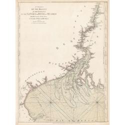
A Chart of the Braces at the Entrance of the Ganges or River...
A Chart of the Braces at the Entrance of the Ganges or River of Hughly with the Course of that River up to the Town of Hughly. Improved from Mr. d’Anville’s Chart of ...
Date: London, 1778
Selling price: ????
Please login to see price!
Sold in 2023
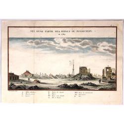
Vue D'Une Partie des Ruines de Pondichery en 1769.
Fine city view of Pondicherry India by Guillaume le Gentil. It was engraved by Gardette in 1769. It has a key at the bottom identifying important buildings in the city.
Date: Paris , 1779
Selling price: ????
Please login to see price!
Sold in 2018
![[Untitled] Sea chart of Ceylon and Southern India.](/uploads/cache/44286-250x250.jpg)
[Untitled] Sea chart of Ceylon and Southern India.
A scarce separately published English Sea Chart of the south coast of India, the island of Ceylon, with inset maps of Gula Bay (Galle) Sri Lanka, Tutocarine Bay (Tuticori...
Date: London, 1779
Selling price: ????
Please login to see price!
Sold in 2019
Carte de la Partie Septentrionale de la Presqu'ile de L'Inde...
Striking map of central and northern India showing rivers, mountains, towns and cities, including Bombay. Beneath the title cartouche, the Bouches du Gange ("Mouth...
Date: Paris, 1780
Selling price: ????
Please login to see price!
Sold in 2018
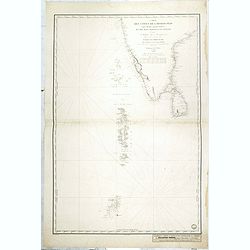
![[Untitled] English Sea Chart.](/uploads/cache/42898-250x250.jpg)
[Untitled] English Sea Chart.
A large, English Sea Chart of southern India, the Maldives (and other) Islands, and the island of 'Zeloan' (Sri Lanka). The interiors are almost bare of any information w...
Date: Anon, ca 1780
Selling price: ????
Please login to see price!
Sold in 2018
Carte de la Partie Inferieure de l'Inde en Deca du Gange. . .
A late eighteenth century map of southern India by the French cartographer Rigobert Bonne. Shows the southern coasts of Malabar and Coromandel. Map extent is from the Dec...
Date: Paris, 1780
Selling price: ????
Please login to see price!
Sold in 2020
Carta Dell' Indostan che comprende il Malabar, Coromandel, e tutta la penisola Dell' India.
This is from a scarce Italian edition of French cartographer Jacques-Nicholas Bellin’s map of southern India and the island of Ceylon (Sri Lanka). The map extent is fro...
Date: Paris, ca 1780
Selling price: ????
Please login to see price!
Sold in 2021
