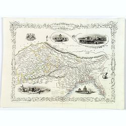
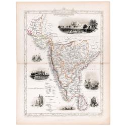
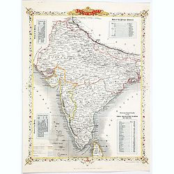
Northern India.
Decorative steel engraved map of Northern India, surrounded 6 decorative vignettes.Taken from "The illustrated atlas and modern history of the world by John Tallis&q...
Date: London, 1851
Selling price: ????
Please login to see price!
Sold in 2018
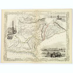
Cabool, the Punjab and Beloochistan.
Decorative steel engraved map of Cabool, the Punjab and Beloochistan, surrounded 3 large, decorative vignettes.Taken from "The illustrated atlas and modern history o...
Date: London, 1851
Selling price: ????
Please login to see price!
Sold in 2017
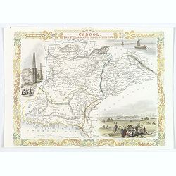
Cabool, the Punjab and Beloochistan.
A decorative steel engraved map of Cabool, the Punjab and Beloochistan, surrounded 3 large, colored, decorative vignettes.Taken from "The illustrated atlas and moder...
Date: London, 1851
Selling price: ????
Please login to see price!
Sold in 2020
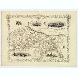
Northern India.
Decorative steel engraved map of Northern India, surrounded 6 decorative vignettes.Taken from "The illustrated atlas and modern history of the world by John Tallis&q...
Date: London, 1851
Selling price: ????
Please login to see price!
Sold in 2020
Southern India.
Original steel engraved map of Southern India. Several vignette scenes, including Shuhur, Jeypoor, Calcutta and Bejapoor. Decorative scrolling and title cartouche around ...
Date: London, Edinburgh & Dublin: J & F Tallis, 1851
Selling price: ????
Please login to see price!
Sold in 2020
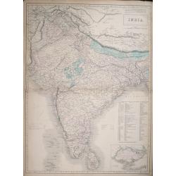
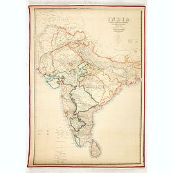
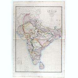
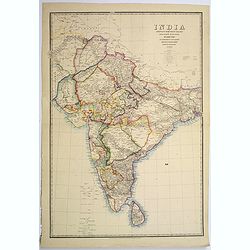
India.
Large detailed map of India by Sidney Hall published by A. &. C. Black in Edinburgh Steel engraving with original color Relief shown by hachures. States shown by tint...
Date: Edinburgh, 1854
Selling price: ????
Please login to see price!
Sold in 2014
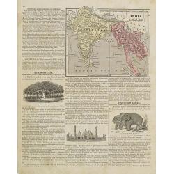
Persia and Arabia. / India and Malaysia.
Map of India and Malaysia. On the verso a map of Persia and Arabia (110x140mm.) . From Sidney E. Morse''s: System of Geography for the use of schools , published by Harpe...
Date: New York, 1855
Selling price: ????
Please login to see price!
Sold in 2011
Map of the Countries lying between Turkey & Birmah, comprising Asia Minor, Persia, India, Egypt & Arabia, and including the Black, Caspian & Red seas by James Wyld, Geographer to the Queen, Charing Cross East. Model of the Earth, Leicester Square, London.
Map of the Countries lying between Turkey & Birmah, comprising Asia Minor, Persia, India, Egypt & Arabia, and including the Black, Caspian & Red seas by James...
Date: London, 1855
Selling price: ????
Please login to see price!
Sold in 2013
Dachinabadae ora Maritima secundum anonymi periplum maris erythrei. (India)
Two ancient maps on one sheet showing India, prepared by Karl Wilhelm Ludwig Muller (1813-1894) and published in "Geographi Graeci Minores". Muller wrote in Lat...
Date: Paris, Ambrosio Firmin Didot, 1855
Selling price: ????
Please login to see price!
Sold in 2017
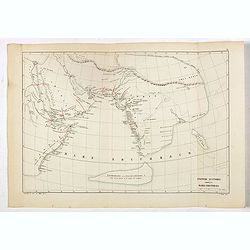
Anonymi auctoris periplus Maris Erythraei.
Delicate map showing the Indian Ocean during ancient times according to the "Stadiasmus Maris Magni", and prepared by Karl Wilhelm Ludwig Muller (1813-1894) and...
Date: Paris, Ambrosio Firmin Didot, 1855
Selling price: ????
Please login to see price!
Sold in 2017
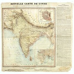
Nouvelle carte de l'Inde pour suivre les opérations militaires dans les possessions anglaises .
Very detailed map of India, printed on very thin paper. With inset plan of Delhi. In dedicate original hand colors. In lower right inset map of the Western Hemisphere, &q...
Date: Paris, ca. 1857
Selling price: ????
Please login to see price!
Sold in 2021
India shewing the post roads and dawk stationsby James Wyld, geographer to the Queen and H.R.H. Prince Albert.
Decorative post road map also showing railways. A color key is showing British possessions, subsidiary states, and protected and independent areas. Scale [ca. 1:4,400,000...
Date: London, ca. 1858
Selling price: ????
Please login to see price!
Sold in 2016
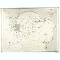
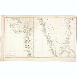
Indian Ocean Ceylon - Point de Galle Bay.
Showing the bay of Galle, surveyed by Mr TH Twynham Master Attendent at Pt de Galle. Also with surveys by Sir. Edward Belcher, and Alexander Dalrymple, first hydrographer...
Date: London, 1858
Selling price: ????
Please login to see price!
Sold
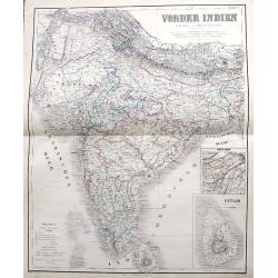
Vorder Indien.
An excellent map of India with nice coloring indicating colonial occupations. With two insets of upper Assam, and Ceylon.
Date: Weimar, 1858
Selling price: ????
Please login to see price!
Sold in 2017
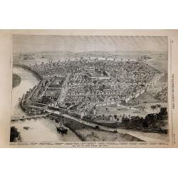
The City of Delhi Before the Siege.
The City of Delhi Before the Siege. An interesting woodblock print of Delhi, published January 16th 1858, in the Illustrated London News.This large bird's eye view of Del...
Date: London, 1858
Selling price: ????
Please login to see price!
Sold in 2017
Asia Centrale ( Tibet, Thian-Scian-Nan-Lu, Mongolia, Gran Deserto, &)
Uncommon map of Tibet prepared by Francesco Costantino Marmocchi. Above the map "Geografia Commerciale". From "Il Globo Atlante di carte Geografiche compil...
Date: Genova, Paolo Rivara fu Giacomo, 1858
Selling price: ????
Please login to see price!
Sold in 2020
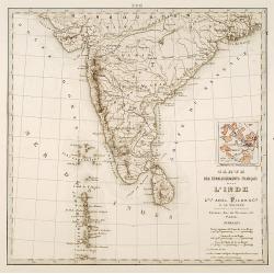
Carte des établissements .. L'Inde..
Detailed map of India. On verso 5 manuscript maps in pen and ink showing "Territoire de Pondichèry", "Territoire de Karikat, scale 1:300.000", "...
Date: Paris 1860
Selling price: ????
Please login to see price!
Sold

The British Possessions In The East Indies, With The Dependent States And Countries Adjacent.
Fantastic map of India, Pakistan, Afganistan, Tibet, Bhutan, and the Himalayas. Extending east to show Siam. With a small inset of the southern India and Ceylon. Large...
Date: Edinburgh, c1860
Selling price: ????
Please login to see price!
Sold in 2013
British India.
A late edition map of British India, published by the London Printing and Publishing Company. Replacing the decorative vignettes of earlier editions are tables of signifi...
Date: London, 1860
Selling price: ????
Please login to see price!
Sold in 2020
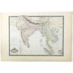
Asie Meridionale. Inde Anglaise et Indo-Chine.
Very detailed map from Atlas Spherodidal & Universel de geographie , Prepared by F.A.Garnier and edited by Jules Renouard, rue de Tournon, Paris. Uncommon map with de...
Date: Paris, 1861
Selling price: ????
Please login to see price!
Sold in 2020
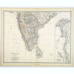
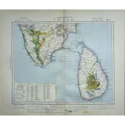
India (Southern Sheet).
A large and detailed steel engraved map sheet (1 of 2 only) of Southern India. Map extent is from Nagpur in the north to Ceylon (Sri Lanka) in the south. Regions are in d...
Date: London, 1861
Selling price: ????
Please login to see price!
Sold in 2021
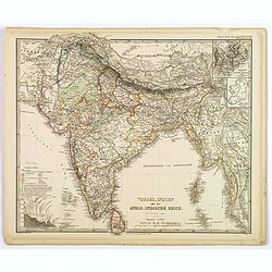
Vorder-Indien oder das Anglo-Indische Reich.
This is a nice example of Stieler's 1863 map of the Indian subcontinent. It covers from the Himalayas in the north as far south as Ceylon (Sri Lanka), and from Sindh in t...
Date: Gotha, 1863
Selling price: ????
Please login to see price!
Sold in 2020
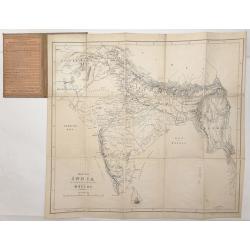
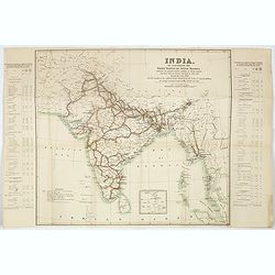
Map of India. . .
Very detailed road, railway and telegraphic map of India showing the post roads. With color key to British possessions, independent-, protected- and subsidiary states. Se...
Date: London, 1855/1864
Selling price: ????
Please login to see price!
Sold
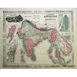
Johnson's Hindostan or British India.
Attractive steel engraved map, extending from the Indus River eastwards with India, Burma, Siam (Thailand), Laos, Cambodia, Malaysia (Malacca), Singapore, and Vietnam (To...
Date: New York, 1864
Selling price: ????
Please login to see price!
Sold in 2012
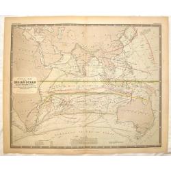
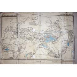
Physical Chart of the Indian Ocean Showing the Temperature of the Water.
This interesting map shows the currents of the air and oacean , direction of the wind , distracts of hurricanes, regions of the monsoons & tyfoons and the temperature...
Date: Edinburgh, 1865
Selling price: ????
Please login to see price!
Sold in 2015
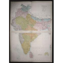
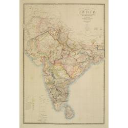
India ( on two sheets)
An extremely highly detailed map of India printed over two sheets North & South, color-coded for the different provinces. The South sheet has Ceylon (present day Sri ...
Date: Edinburgh 1870
Selling price: ????
Please login to see price!
Sold in 2015
Map of India to Illustrate the History of the Mutiny .
An unusual subject for this folding map of India by James Wyld the junior, the map covers the area from Afghanistan and Cashmere in the North to Ceylon(Sri Lanka) in the ...
Date: London, 1872
Selling price: ????
Please login to see price!
Sold in 2016
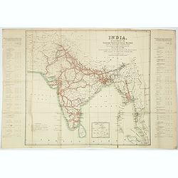
Road, Railway & Telegraphic map of India shewing the post roads and dawk stations. . .
A large, decorative post road map also showing Indian railways. A color key is showing British possessions, subsidiary states, and protected and independent areas. Scale ...
Date: London, ca. 1872/1873
Selling price: ????
Please login to see price!
Sold in 2019
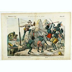
Un Reclutatore in India. Papagallo No. 42. Anno VI.
British in India. Design by Augusto Grossi. Taken from the Italian satirical newspaper Il Papagallo, a satirical magazine founded in January 1873 by Augusto Grossi (1835-...
Date: Bologne, 1878
Selling price: ????
Please login to see price!
Sold in 2019
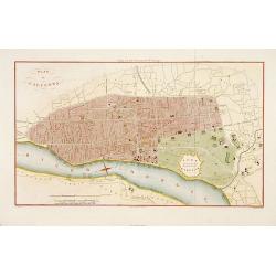
Plan de Calcutta.
Detailed plan of Calcutta, engraved by F. Dien and published in "Voyage aux Indes Orientales" de Charles Belanger.
Date: Paris, c.1880
Selling price: ????
Please login to see price!
Sold in 2015
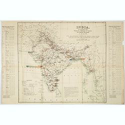
India shewing the post roads and dawk stations by James Wyld, geographer to the Queen and H.R.H. Prince Albert.
A large, decorative post road map also showing Indian railways. A color key is showing British possessions, subsidiary states, and protected and independent areas. Scale ...
Date: London, ca. 1880
Selling price: ????
Please login to see price!
Sold in 2017
![[142 Indian Mica paintings.]](/uploads/cache/42949-250x250.jpg)
[142 Indian Mica paintings.]
One hundred and forty-two Mica Paintings of castes, people of India, trades-people, musicians, snake charmers.The majority of these paintings were produced in standard se...
Date: India, 1850 to ca.1880
Selling price: ????
Please login to see price!
Sold in 2019
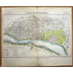
Plan of the City of Calcutta.
A highly detailed late -19th century plan of the city of Calcutta. It depicts the entire city in remarkable detail, noting individual streets, important public buildings,...
Date: London, 1881
Selling price: ????
Please login to see price!
Sold in 2020
A set of Twelve maps of India.
>A set of 12 highly detailed and beautifully colored maps of India at the time of the British Raj. The maps show in high detail; Railways existing and under constructi...
Date: London, 1881
Selling price: ????
Please login to see price!
Sold in 2019
Trigonometrical Branch Survey of India, Sheet No6 of North Eastern Frontier Parts of Tibet, Sikhim and Bhutan
A well-used map of the area surrounding Lhasa. Published under the direction of Colonel G. C. De Pree, Surveyor General of India.
Date: Dehra Dun, 1885
Selling price: ????
Please login to see price!
Sold in 2016
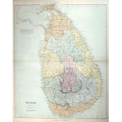
CEYLON
A fine detailed map of Ceylon with the provinces colored in separate tints. The districts are separated by narrow red lines and their names underlined in red A railway ru...
Date: London, 1887
Selling price: ????
Please login to see price!
Sold in 2014
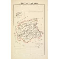
Mission du Coïmbatour.
Important missionary centered on Coimbatour. It is the Third largest city and urban agglomeration in the Indian state of Tamil Nadu, prepared by Adrien Launay, who was a ...
Date: Lille, 1890
Selling price: ????
Please login to see price!
Sold in 2017
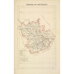
Mission du Maïssour.
Important missionary map centered on Mysor, prepared by Adrien Launay, who was a French Missionary and later chronicler of the history of the French Missions in Indo-Chin...
Date: Lille, 1890
Selling price: ????
Please login to see price!
Sold in 2017
![[Untitled] Map of Northern India, Tibet, Nepal, Bhutan and surrounding countries.](/uploads/cache/42031-250x250.jpg)
[Untitled] Map of Northern India, Tibet, Nepal, Bhutan and surrounding countries.
The top sheet (No.47) of a two sheet map centered on Nepal, Bhutan and Tibet. Also covered by the map are: Northern India, Afghanistan, Pakistan, Turkistan, far Eastern C...
Date: London, ca 1890
Selling price: ????
Please login to see price!
Sold in 2018
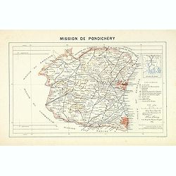
Mission du Kouang-Ton.
Important map of Pondichery in India, prepared by Adrien Launay, who was a French Missionary and later chronicler of the history of the French Missions in Indo-China at e...
Date: Lille, 1890
Selling price: ????
Please login to see price!
Sold in 2026
India. To illustrate the goods traffic on Indian ralways . . .
Large folded map of India, Ceylon, Malaysia, illustrating the goods traffic on Indian railways for the year 1891. A small inset showing the continuation until Singapore.T...
Date: London, 1891
Selling price: ????
Please login to see price!
Sold in 2017
India. To illustrate the passengers traffic on India railways, showing the average number of passengers carried per mile over the various sections of each line, during the year 1891 . . .
Large folded map of India, Ceylon, Malaysia, showing the traffic of passengers by train for the year 1891. A small inset showing the continuation until Singapore.Text pan...
Date: London, 1891
Selling price: ????
Please login to see price!
Sold in 2017
India. To illustrate the principal centres of traffic on Indian railways.
Large folded map of India, Ceylon, Malaysia, illustrating the principal centres of traffic on Indian railways for the year 1891.Text panels to the side : "Principal ...
Date: London, 1891
Selling price: ????
Please login to see price!
Sold in 2017
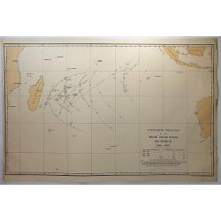
Cyclone tracks in the South Indian Ocean, December 1848-1885.
A map of the tracks of cyclones recorded in December for the years 1848 to 1885, except for years 1849, 1850 and 1853, published in London. Printed for H.M.S.O. by Eyre a...
Date: London, 1891
Selling price: ????
Please login to see price!
Sold in 2018
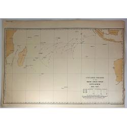
Cyclone Tracks in the South Indian Ocean, November 1848-1885.
A map of the tracks of cyclones recorded in November for the years 1848 to 1885, except for years 1849, 1850 and 1853, published in London. Printed for H.M.S.O. by Eyre a...
Date: London, 1891
Selling price: ????
Please login to see price!
Sold in 2018
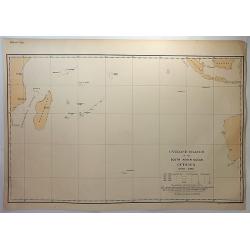
Cyclone tracks in the South Indian Ocean, October 1848-1885.
A map of the tracks of cyclones recorded in October for the years 1848 to 1885, except for years 1849, 1850 and 1853, published in London. Printed for H.M.S.O. by Eyre an...
Date: London, 1891
Selling price: ????
Please login to see price!
Sold in 2018
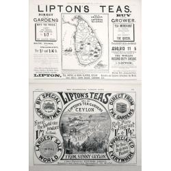
Map of Ceylon shewing Lipton's Tea Estates.
Two Adverts for Lipton's Tea the first one has a map of Ceylon showing their estates on the Island set in advertising text dated December 25th 1897, The second is an adve...
Date: London, 1897
Selling price: ????
Please login to see price!
Sold in 2014
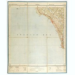
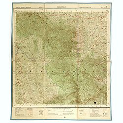
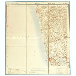
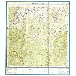
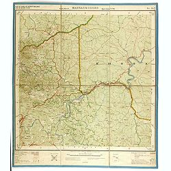
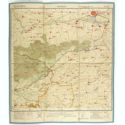
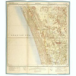
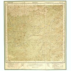
Part of district Malabar. MADRAS NO 49 M11.
Very detailed "Survey of India" map made by trigonometric surveying techniques. Season 1912-1913 and published in 1914.This "Survey of India" map was ...
Date: Calcutta, Superintendent government printing, India, 1909
Selling price: ????
Please login to see price!
Sold in 2014
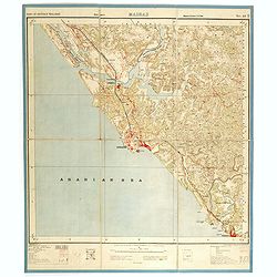
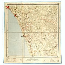
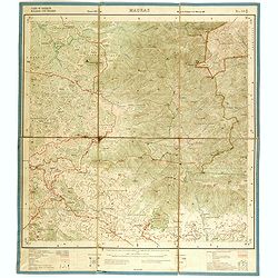
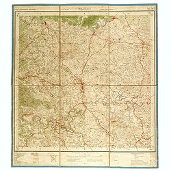
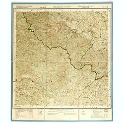
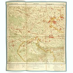
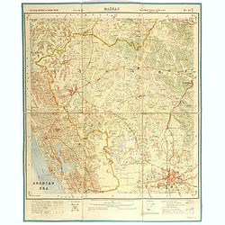
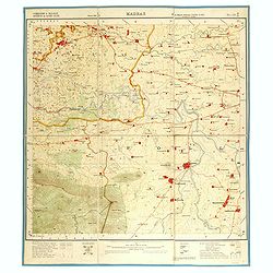
Part of district Malabar. MADRAS NO 49 M5.
Very detailed "Survey of India" map made by trigonometric surveying techniques. Season 1912-1913 and published in 1914.This "Survey of India" map was ...
Date: Calcutta, Superintendent government printing, India, 1909
Selling price: ????
Please login to see price!
Sold in 2014
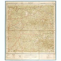
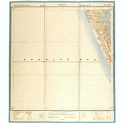
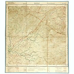
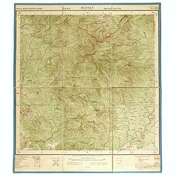
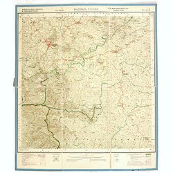
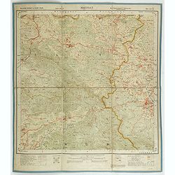
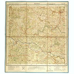
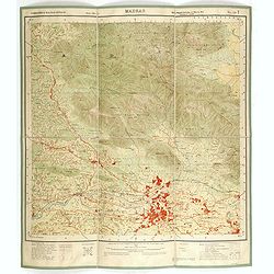
Part of district Malabar and of Mahé. MADRAS NO 49 M9.
Very detailed "Survey of India" map made by trigonometric surveying techniques. Season 1912-1913 and published in 1914.This "Survey of India" map was ...
Date: Calcutta, Superintendent government printing, India, 1909
Selling price: ????
Please login to see price!
Sold in 2014
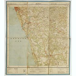
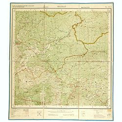
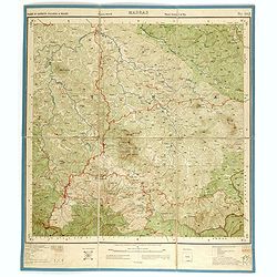
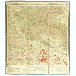
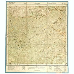
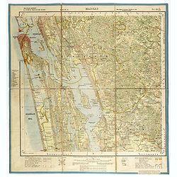
Part of district Malabar. MADRAS. NO 49 M16.
Very detailed "Survey of India" map made by trigonometric surveying techniques. This "Survey of India" map was published under the direction of Colone...
Date: Calcutta, Superintendent government printing, India, 1909
Selling price: ????
Please login to see price!
Sold in 2015
![[India and Indochina map with Ottoman script]](/uploads/cache/44320-250x250.jpg)
[India and Indochina map with Ottoman script]
Post card size map in Ottoman script showing India and Indochina prepared by Mehmet EŞREF in a small atlas : عموم...
Date: Istanbul, 1325 or 1909
Selling price: ????
Please login to see price!
Sold in 2019
Part of district Malabar. MADRAS NO 49 M14.
Very detailed "Survey of India" map made by trigonometric surveying techniques. Season 1912-1913 and published in 1914.This "Survey of India" map was ...
Date: Calcutta, Superintendent government printing, India, 1910
Selling price: ????
Please login to see price!
Sold in 2014
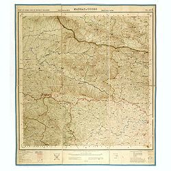
Part of Coorg and of district Malabar. MADRAS & COORG NO 49 M13.
Very detailed "Survey of India" map made by trigonometric surveying techniques. Season 1912-1913 and published in 1914.This "Survey of India" map was ...
Date: Calcutta, Superintendent government printing, India, 1910
Selling price: ????
Please login to see price!
Sold in 2014
Part of district Malabar and of Mahé. MADRAS NO 49 M10.
Very detailed "Survey of India" map made by trigonometric surveying techniques. Season 1912-1913 and published in 1914.This "Survey of India" map was ...
Date: Calcutta, Superintendent government printing, India, 1910
Selling price: ????
Please login to see price!
Sold in 2014
Part of district Malabar. MADRAS NO 49 N14.
Very detailed "Survey of India" map made by trigonometric surveying techniques. Season 1912-1913 and published in 1914.This "Survey of India" map was ...
Date: Calcutta, Superintendent government printing, India, 1910
Selling price: ????
Please login to see price!
Sold in 2014
Part of district Malabar. MADRAS NO 49 N13.
Very detailed "Survey of India" map made by trigonometric surveying techniques. Season 1912-1913 and published in 1914.This "Survey of India" map was ...
Date: Calcutta, Superintendent government printing, India, 1910
Selling price: ????
Please login to see price!
Sold in 2014
Part of district Malabar and Nilgiris. MADRAS NO 58 A8.
Very detailed "Survey of India" map made by trigonometric surveying techniques. Season 1912-1913 and published in 1914.This "Survey of India" map was ...
Date: Calcutta, Superintendent government printing, India, 1910
Selling price: ????
Please login to see price!
Sold in 2014
Part of district Malabar and Nilgiris. MADRAS NO 58 A7.
Very detailed "Survey of India" map made by trigonometric surveying techniques. Season 1912-1913 and published in 1914.This "Survey of India" map was ...
Date: Calcutta, Superintendent government printing, India, 1910
Selling price: ????
Please login to see price!
Sold in 2014
Part of district Nilgiris and Malabar and of Mysore State. MADRAS NO 58 A6.
Very detailed "Survey of India" map made by trigonometric surveying techniques. Season 1912-1913 and published in 1914.This "Survey of India" map was ...
Date: Calcutta, Superintendent government printing, India, 1910
Selling price: ????
Please login to see price!
Sold in 2014
Part of district Malabar and Mysore. MADRAS & MYSORE NO 58 A5.
Very detailed "Survey of India" map made by trigonometric surveying techniques. Season 1912-1913 and published in 1914.This "Survey of India" map was ...
Date: Calcutta, Superintendent government printing, India, 1910
Selling price: ????
Please login to see price!
Sold in 2014
Part of district Malabar. MADRAS NO 58 A4.
Very detailed "Survey of India" map made by trigonometric surveying techniques. Season 1912-1913 and published in 1914.This "Survey of India" map was ...
Date: Calcutta, Superintendent government printing, India, 1910
Selling price: ????
Please login to see price!
Sold in 2014
Part of district Malabar & Nilgiri. MADRAS NO 58 A3.
Very detailed "Survey of India" map made by trigonometric surveying techniques. Season 1912-1913 and published in 1914.This "Survey of India" map was ...
Date: Calcutta, Superintendent government printing, India, 1910
Selling price: ????
Please login to see price!
Sold in 2014
Part of district Malabar & Nilgiri. MADRAS NO 58 A2.
Very detailed "Survey of India" map made by trigonometric surveying techniques. Season 1912-1913 and published in 1914.This "Survey of India" map was ...
Date: Calcutta, Superintendent government printing, India, 1910
Selling price: ????
Please login to see price!
Sold in 2014
Part of district Malabar and of Mysore State. MADRAS NO 58 A1.
Very detailed "Survey of India" map made by trigonometric surveying techniques. Season 1912-1913 and published in 1914.This "Survey of India" map was ...
Date: Calcutta, Superintendent government printing, India, 1910
Selling price: ????
Please login to see price!
Sold in 2014
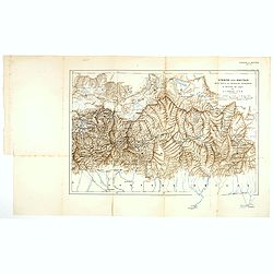
Sikkim and Bhutan wit parts of Adjacent countries. . .
Lithographed map by John Claude White of Sikkim and Bhutan showing Talung, Tongshyong and Passanram glaciers. The map was published in the Geographical Journal of 1910, t...
Date: London, 1910
Selling price: ????
Please login to see price!
Sold in 2017
District Malabar & Padinalknad & Yedenalknad Tâluks. MADRAS & COORG NO 48 P12.
Very detailed "Survey of India" map made by trigonometric surveying techniques. Season 1912-1913 and published in 1914.This "Survey of India" map was ...
Date: Calcutta, Superintendent government printing, India, 1911
Selling price: ????
Please login to see price!
Sold in 2014
District Malabar &Kiggatnäd & Yedenalknad Tâluks. MADRAS & COORG NO 48 P16.
Very detailed "Survey of India" map made by trigonometric surveying techniques. Season 1912-1913 and published in 1914.This "Survey of India" map was ...
Date: Calcutta, Superintendent government printing, India, 1911
Selling price: ????
Please login to see price!
Sold in 2014
Coimbatore & Malabar districts & Cochin states. MADRAS NO 58 B-13
Very detailed "Survey of India" map made by trigonometric surveying techniques. Season 1909-1910 and published in 1912.This "Survey of India" map was ...
Date: Calcutta, Superintendent government printing, India, 1912
Selling price: ????
Please login to see price!
Sold in 2014
Malabar district & Cochin state. MADRAS NO 58 B-10
Very detailed "Survey of India" map made by trigonometric surveying techniques. Season 1909-1910 and published in 1912.This "Survey of India" map was ...
Date: Calcutta, Superintendent government printing, India, 1912
Selling price: ????
Please login to see price!
Sold in 2014
Malabar district & Cochin state. MADRAS NO 58 B-6
Very detailed "Survey of India" map made by trigonometric surveying techniques. Season 1909-1910 and published in 1912.This "Survey of India" map was ...
Date: Calcutta, Superintendent government printing, India, 1912
Selling price: ????
Please login to see price!
Sold in 2014
Coimbatore & Malabar districts. MADRAS NO 58 B-9
Very detailed "Survey of India" map made by trigonometric surveying techniques. Season 1909-1910 and published in 1912.This "Survey of India" map was ...
Date: Calcutta, Superintendent government printing, India, 1912
Selling price: ????
Please login to see price!
Sold in 2014
Malabar district & Cochin & Travancore States. MADRAS NO 58 B-3
Very detailed "Survey of India" map made by trigonometric surveying techniques. Season 1909-1911 and published in 1912.This "Survey of India" map was ...
Date: Calcutta, Superintendent government printing, India, 1912
Selling price: ????
Please login to see price!
Sold in 2014
Malabar district & Cochin State. MADRAS NO 58 B-2
Very detailed "Survey of India" map made by trigonometric surveying techniques. Season 1909-1910 and published in 1912.This "Survey of India" map was ...
Date: Calcutta, Superintendent government printing, India, 1912
Selling price: ????
Please login to see price!
Sold in 2014
Malabar district & cochin states. MADRAS NO 58 B1.
Very detailed "Survey of India" map made by trigonometric surveying techniques. Season 1912-1913 and published in 1914.This "Survey of India" map was ...
Date: Calcutta, Superintendent government printing, India, 1912
Selling price: ????
Please login to see price!
Sold in 2014
Combatore, Malabar & Nilgiri Districts. MADRAS NO 58 A12.
Very detailed "Survey of India" map made by trigonometric surveying techniques. Season 1912-1913 and published in 1914.This "Survey of India" map was ...
Date: Calcutta, Superintendent government printing, India, 1912
Selling price: ????
Please login to see price!
Sold in 2014
Coimbatore & Malabar Districts& cochin state. MADRAS NO 58 B14.
Very detailed "Survey of India" map made by trigonometric surveying techniques. Season 1912-1913 and published in 1914.This "Survey of India" map was ...
Date: Calcutta, Superintendent government printing, India, 1912
Selling price: ????
Please login to see price!
Sold in 2014
Coimbatore & Malabar districts. MADRAS NO 58 B-9.
Very detailed "Survey of India" map made by trigonometric surveying techniques. Season 1909-1910 and published in 1912.This "Survey of India" map was ...
Date: Calcutta, Superintendent government printing, India, 1912
Selling price: ????
Please login to see price!
Sold in 2015
Malabar district & cochin & Travancore states. MADRAS NO 58 C45.
Very detailed "Survey of India" map made by trigonometric surveying techniques. Season 1912-1913 and published in 1914.This "Survey of India" map was ...
Date: Calcutta, Superintendent government printing, India, 1913
Selling price: ????
Please login to see price!
Sold in 2014
