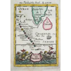
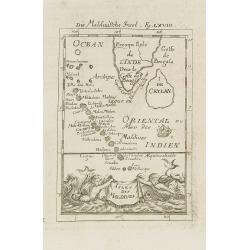
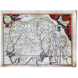
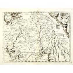
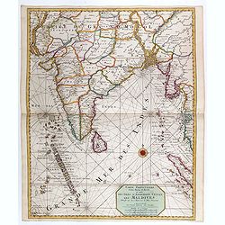
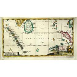
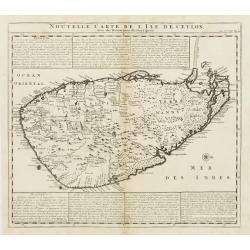
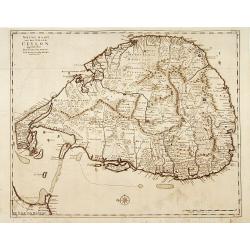
Isles de Maldives
Alain Manneson Mallet (1603-1706) published in 1683 his ' Description de l' Univers' in 5 volumes. In 1686 a German edition appeared.
Date: Paris, 1683
Selling price: ????
Please login to see price!
Sold
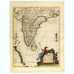
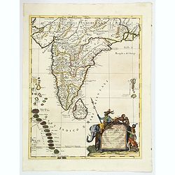
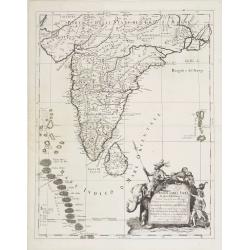
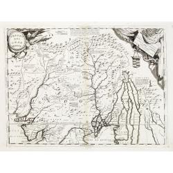
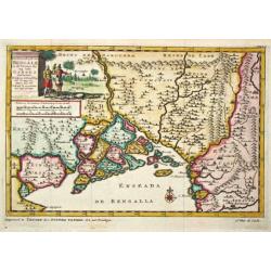
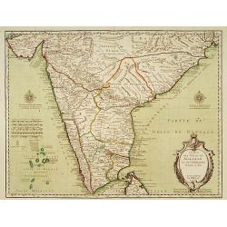
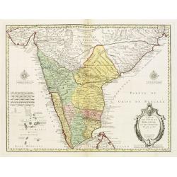
Penisola dell India di là dal Gange. . .
Giacomo Rossi's fine late 17th century map of India and Ceylon. Issued in Il Mercurio geografico In lower right hand corner a large title cartouche.The cartographer was G...
Date: Rome, 1683
Selling price: ????
Please login to see price!
Sold in 2015
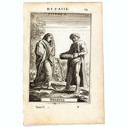
Bramins (de L'Asie / Figure L).
A fine and uncommon early 17th century miniature costume plate showing Brahmins from India.From the French text edition of Description d'Univers, 1683. by Allain Manneson...
Date: Paris, 1683
Selling price: ????
Please login to see price!
Sold in 2016
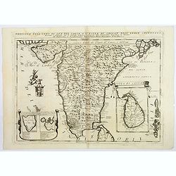
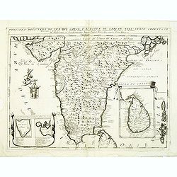
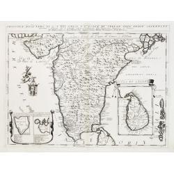
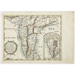
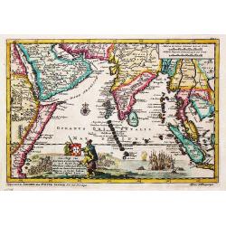
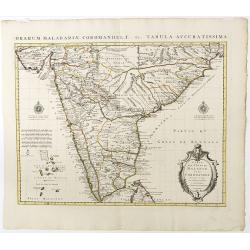
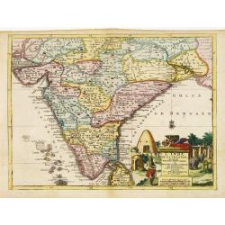
Penisola dell'India di qua dal Gange et Isole intorno ad essa adiacenti. DA GIACOMO CANTELLI DA VIGNOLA.
This is an uncommon map showing the southern part of India, with Sri Lanka and Maldives, from "Mercurio Geografico", published in Rome by G. de Rossi. A very ni...
Date: Italy, 1683
Selling price: ????
Please login to see price!
Sold in 2020
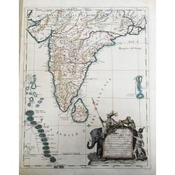
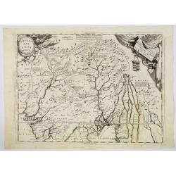
Penisola Dell India di qua dal Gange. . .
A lovely, decorative map of India, Ceylon (Sri Lanka) the Maldive Islands, and surrounds, by Cantelli da Vignola, and published by Rossi in Rome. Plenty of good map detai...
Date: Rome, 1683
Selling price: ????
Please login to see price!
Sold in 2020
Isles de Maldives.
A charming late 17th century French map of the Maldives Islands.From the German text edition published by Davis Zunners. Allain Manneson Mallet (1630-1706), a well travel...
Date: Frankfurt, 1684
Selling price: ????
Please login to see price!
Sold in 2011
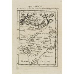
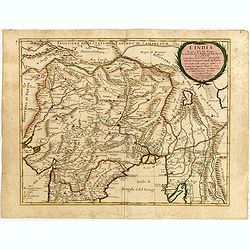
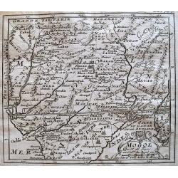
Partie de la Terre Ferme de l\'Inde ou l\'Empire du Mongol.
Map of India. From the German text edition published by Davis Zunners. Allain Manneson Mallet (1630-1706), a well traveled military engineer and geographer who worked in ...
Date: Frankfurt, 1684
Selling price: ????
Please login to see price!
Sold in 2011
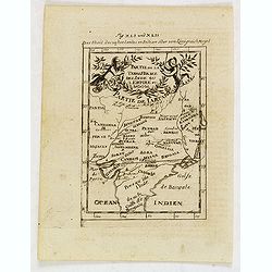
Partie de la Terre Ferme de l'Inde ou l'Empire du Mongol.
Map of India. From the German text edition published by Johann David Zunners of Frankfurt. Allain Manneson Mallet (1630-1706), a well traveled military engineer and geogr...
Date: Frankfurt, 1684
Selling price: ????
Please login to see price!
Sold in 2020
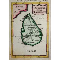
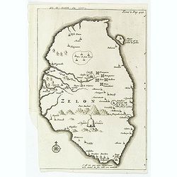
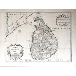
Ancienne Isle Taprobane.
Alain Manneson Mallet (1603-1706) published in 1683 his ' Description de l' Univers' in 5 volumes. In 1686 a German edition appeared.A map from Alain Manesson Mallet's 'D...
Date: Paris, 1686
Selling price: ????
Please login to see price!
Sold in 2017
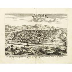
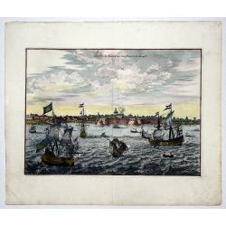
Odia in Siam
Rare panoramic town-view of Bangkok, published in J.C. Wagner "Interiora orientis detecta, oder grundrichtige und eigentl. Bescheibung aller . . . Reiche des Orients...
Date: Augsburg, Koppmayer,1686
Selling price: ????
Please login to see price!
Sold in 2011
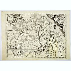
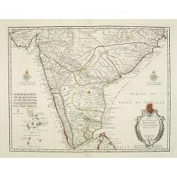
Penisola dell India di là dal Gange et Isole intorno ad essa adiacenti..
Giacomo Rossi's fine late 17th century map of India with Ceylon and Maldives. Issued in Il Mercurio geografico In lower right hand corner a large title cartouche with ded...
Date: Rome, 1683-1688
Selling price: ????
Please login to see price!
Sold
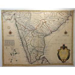
L'India. . .
Giacomo Rossi's fine late 17th century map of India. Issued in Il Mercurio geografico In upper right corner a tittle cartouche.
Date: Rome, 1683-1688
Selling price: ????
Please login to see price!
Sold in 2015
![[Globe Gore of the Arabian Sea]](/uploads/cache/17783-250x250.jpg)
[Globe Gore of the Arabian Sea]
Originally engraved to be pasted onto a globe in 1688, this edition was printed with a text underneath it. It shows the Arabian Sea from Oman to Sri Lanka, with a roundel...
Date: Venice 1690
Selling price: ????
Please login to see price!
Sold
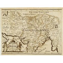
Impero del Gran Mogol.
Northern India, with Pakistan, Bangladesh and the western part of Burma. In the top corners are cartouches for title and dedication, both with a martial theme. Engraved i...
Date: Venice 1690
Selling price: ????
Please login to see price!
Sold
![[Globe Gore of the Arabian Sea]](/uploads/cache/26333-250x250.jpg)
[Globe Gore of the Arabian Sea]
Originally engraved to be pasted onto a globe in 1688, this edition was printed with a text underneath it. It shows the Arabian Sea from Oman to Sri Lanka, with a roundel...
Date: Venice, 1690
Selling price: ????
Please login to see price!
Sold in 2011
Penisola Dell' Indo di qua del Gange e L'Isola di Ceilan nell' Indie Orientale. . .
Coronelli's attractive double page copper engraved map of India below the Tropic of Cancer, with a pair of lovely insets of Trincomalee harbour and the island of Ceylon (...
Date: Venice 1690
Selling price: ????
Please login to see price!
Sold in 2018
Impero del Gran Mogol.
Northern India, with Pakistan, Bangladesh and the western part of Burma. Including Cabulistan, Kandauna, Harduari, Binsola, Burchar, Kachemire, Iamba, Ragepor and others....
Date: Venice, 1690
Selling price: ????
Please login to see price!
Sold in 2019
Impero del Gran Mogol.
Northern India, with Pakistan, Bangladesh and the western part of Burma. Including Cabulistan, Kandauna, Harduari, Binsola, Burchar, Kachemire, Iamba, Ragepor and others....
Date: Venice, 1690
Selling price: ????
Please login to see price!
Sold in 2019
IMPERO DEL GRAN MOGOL.
A fine ,very rarely contempory colored ! map.Coronelli's maps are rarely to be found in contempory color ! From an Italian oldcolored composite atlas , otherwise usually ...
Date: Venice, ca 1690
Selling price: ????
Please login to see price!
Sold in 2021
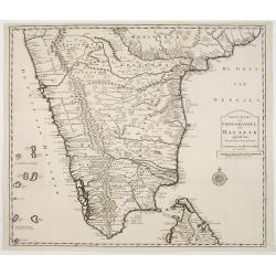
Penisola dell'Indo di qua del Gange, e l isola di Ceilan. . .
India below the Tropic of Cancer, with an insets of Ceylon and Trincomalee. Cartouche to the left depicts a Cherub holding a coat of arms.From Coronelli's rare Corso Geog...
Date: Venice, 1692
Selling price: ????
Please login to see price!
Sold in 2012
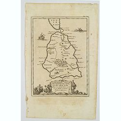
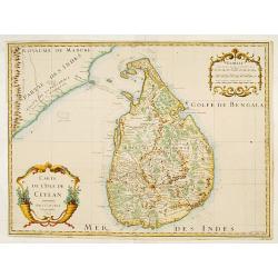
Taprobanae Insulae Descriptio ex Ptol. Incolae eidem Salae. . .
The uncommon and pleasant map of Taprobana (Sri Lanka) and the southern tip of India is based on the work of Ptolemy. It shows only ancient place names and is embellished...
Date: Utrecht, ca 1695
Selling price: ????
Please login to see price!
Sold in 2020
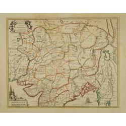
Impero del Gran Mogol. . .
A beautiful and flamboyantly engraved large-scale map of Northern India at the time of the Mogul Empire. Also including Bangaledesh, Pakistan, Nepal and the Himalayas.The...
Date: Venice, ca. 1696
Selling price: ????
Please login to see price!
Sold in 2012
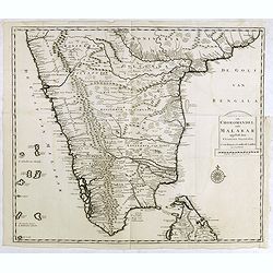
Penisola dell'Indo di qua del Gange, e l isola di Ceilan..
India below the Tropic of Cancer, with an insets of Ceylon and Trincomalee.The remarkable Vincenzo Coronelli (1650-1718), encyclopaedist, geographer, inventor and Doctor ...
Date: Venice 1698
Selling price: ????
Please login to see price!
Sold
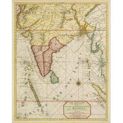
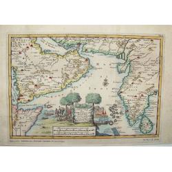
Carte particuliere d'une Partie d'Asie.. Ceylon, Maldives..
Intriguing map of India, Ceylon, Maldives and East Coast of Sumatra, and Malaysia. From Suite du Neptune François, ou Atlas Nouveau des Cartes Marines.From the rare and ...
Date: Amsterdam 1700
Selling price: ????
Please login to see price!
Sold
![[No title] [wall map of Southern India, Ceylon and part of Malaysia]](/uploads/cache/22782-250x250.jpg)
[No title] [wall map of Southern India, Ceylon and part of Malaysia]
An attractive large wall map of Southern India, Ceylon and part of Malaysia. Originally in 2 sheets, this is the bottom sheet.With 3 inset plans showing the surroundings ...
Date: Paris, c. 1700
Selling price: ????
Please login to see price!
Sold
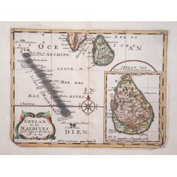
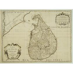
Ceylan, et les Maldives.
Exquisite map of Sri Lanka and the Maldives, with the southern tip of India shown at the top. Sri Lanka is shown in an inset named Ceylan Isle, qui est la Taprobane des A...
Date: Amsterdam 1700
Selling price: ????
Please login to see price!
Sold in 2026
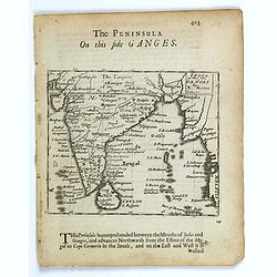
The Penisula on this side Ganges.
This map appeared in Modern's rare 'Atlas Terestris', first published in 1687. This map is the uncommon English text map of India, Ceylon, the Maldives and the Malaya Pen...
Date: London, 1700
Selling price: ????
Please login to see price!
Sold in 2016
Carte particuliere d'une Partie d'Asie ou sont le Isles d'Andemaon, Ceylan, Les Maldives. . .
Intriguing map of India, Ceylon, Maldives and East Coast of Sumatra, and Malaysia. Sumatra peeks out of the eastern border, with the southwest peninsula showing the Kingd...
Date: Amsterdam, 1700
Selling price: ????
Please login to see price!
Sold in 2020
Presqu Isle de L'Inde. deca la Gange.. .
Two maps together on one sheet.
Date: Amsterdam, 1700
Selling price: ????
Please login to see price!
Sold in 2018
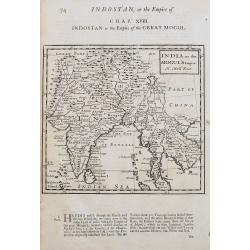
India or the Mogul's Empire.
A detailed map showing India, Sri Lanka, Tibet, Siam, Cambodia, etc. Names towns, rivers, and islands. With text below the map and on verso.
Date: London, ca 1701
Selling price: ????
Please login to see price!
Sold in 2020
![Bandel, de Reede van de vermaerde Koopstadt Arrakan. [Chittagong]](/uploads/cache/24998-250x250.jpg)
Bandel, de Reede van de vermaerde Koopstadt Arrakan. [Chittagong]
From Schenk's Hecatompolis sive Totius Terrarum Oppida Nobiliora Centrum.. , a collection of 100 views, dedicated to the 14-year old Prussian crown prince, the later king...
Date: Amsterdam, 1702
Selling price: ????
Please login to see price!
Sold in 2011
![Bandel, de Reede van de vermaerde Koopstadt Arrakan. [Chittagong]](/uploads/cache/32894-250x250.jpg)
Bandel, de Reede van de vermaerde Koopstadt Arrakan. [Chittagong]
View of Chittagong. From Schenk's Hecatompolis sive Totius Terrarum Oppida Nobiliora Centrum.. , a collection of 100 views, dedicated to the 14-year old Prussian crown pr...
Date: Amsterdam, 1702
Selling price: ????
Please login to see price!
Sold in 2014

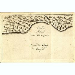
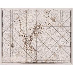
Baye de Matecalo Dans l'Isle de Ceyon / Partie du Golfe de Bengale.
Uncommon map of the Bay of Matecalo on Ceylon in the Gulf of Bengal. From the French reissue of the account of early Dutch voyages first published in 1608 by Commelin. Th...
Date: Amsterdam, E. Roger, 1703
Selling price: ????
Please login to see price!
Sold in 2016
Isle de Zeilan ou Ceilon.
Uncommon map of Sri Lanka (Ceylon). From the French reissue of the account of early Dutch voyages first published in 1608 by Commelin. The French translation was carried ...
Date: Amsterdam, E. Roger, 1703
Selling price: ????
Please login to see price!
Sold in 2012
Mogol.
Detailed map of the Mughal Empire, which controlled much of South Asia by the early 18th century.
Date: Paris, c.1704
Selling price: ????
Please login to see price!
Sold in 2013
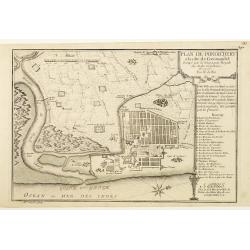
Plan de Pondichery la côte of Coromandel occupé pair la Compagnie Royale DES Indes cartographic Orientales..
Detailed plan of the town of Pondichery, by Nicolas De Fer, who was a royal French geographer.
Date: Paris 1705
Selling price: ????
Please login to see price!
Sold
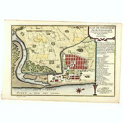
Plan de Pondichery la côte of Coromandel occupé par la Compagnie Royale des Indes cartographic Orientales..
Detailed plan of the town of Pondicherry, founded in 1674 as the capital of French India. A masterpiece of European Enlightenment Era urban planning, it was predicated on...
Date: Paris, 1705
Selling price: ????
Please login to see price!
Sold in 2020
Scheep-Togt door Don Henrique de Menezes...
This is a desirable first state example of the Indian Ocean / India and Sri Lanka regions, from Van der Aa's NAAUKEURIGE VERSAMELING DER GENDENK-WAARDIGSTE ZEE EN LAND-RE...
Date: Leiden, ca. 1707
Selling price: ????
Please login to see price!
Sold in 2008
Het Koninkrijk van Bengalen en de Vloeden die zig inde Ganges ontlasten.
Pieter van der Aa was a prolific publisher. He published a.o. ' Naaukeurige versameling der gedenkwaardigste zee- en land-reysen', a series of accounts of voyages (1706-0...
Date: Leiden, 1707
Selling price: ????
Please login to see price!
Sold
De Eilanden Maldives.
Pieter van der Aa was a prolific publisher. He published a.o. ' Naauwkeurge versameling der gedenkwaardigste zee- en land-reysen', a series of accounts of voyages (1706-0...
Date: Leiden, 1707
Selling price: ????
Please login to see price!
Sold
Zee-Togt van Alfonso d' Albuquerque na de Roode Zee, d' Arabize en Persize Kusten, met die van Ormus, Guzaratte, Goa, Malacca en Verder Indien tot aan't Eiland Java.
Pieter van der Aa was a prolific publisher. He published a.o. ' Naaukeurige versameling der gedenkwaardigste zee- en land-reysen', a series of accounts of voyages (1706-0...
Date: Leiden, 1707
Selling price: ????
Please login to see price!
Sold
L'Empire du Mongol sur les Memoires de Mr. Manchouri.
Map of Empire of the Mogol from Memoirs of Mr. Manouchi (Manucci) . Published in Histoire Generale de l´Emppire du Mogol depuis sa Fondation jusqu´a Present, sur les Me...
Date: Paris 1715
Selling price: ????
Please login to see price!
Sold
Nouvelle Carte de L'Isle de Ceylon, avec des remarques Historiques.
Handsome and very detailed map of the island. The mountainous topography is graphically presented, along with roads, locations of Dutch forts, gem and salt mines. Numerou...
Date: Amsterdam 1718
Selling price: ????
Please login to see price!
Sold
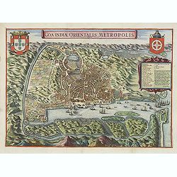
Goa Indiae orientalis metropolis.
A fine example of a rare plan of this important Indian city and port, the focal point for Portuguese trading activity in southern Asia. Pictorial map by Pieter Boudewyn v...
Date: Leiden, 1719
Selling price: ????
Please login to see price!
Sold in 2015
![Carte nouvelle des Terres de Cucan. . . [India]](/uploads/cache/38871-250x250.jpg)
Carte nouvelle des Terres de Cucan. . . [India]
All the trading posts of the V.O.C. are marked with a flag. Prepared by H.Reland (1676-1718) a professor active in Utrecht and specialised in Asian languages, geography a...
Date: Amsterdam, 1719
Selling price: ????
Please login to see price!
Sold in 2017
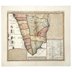
Carte Nouvelle des Terres de CUCAN, de CANARA, de MALABAR, de MADURA,m et de COROMANDL.
India south of Goa, from Chatelain's monumental 'Atlas Historique', published in Amsterdam. The map includes three text boxes giving particulars of the region and its div...
Date: Amsterdam, 1719
Selling price: ????
Please login to see price!
Sold in 2019
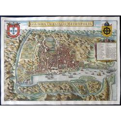
Goa Indiae orientalis metropolis.
A decorative and detailed birds-eye view of the city and harbour of Goa. The map is based upon an earlier map by Jan Huygen van Linschoten. Linschoten served 6 years as t...
Date: Leiden, 1719
Selling price: ????
Please login to see price!
Sold in 2020
La Ville de SURATTE, dans l'Empire du Mogol.
A copper engraving of Suratte, an important former trade post of the VOC, seen here with some VOC ships and local vessels in the foreground. From Pieter van der Aa's in &...
Date: Leiden, 1719
Selling price: ????
Please login to see price!
Sold in 2020
Magni Mogolis Imperium de novo correctum et Divisum..
A rare issue of this attractive map of northern India and Central Asia. The map was originally published by F.de Wit. P.Mortier acquired de Wit's stock of copperplates in...
Date: Amsterdam 1720
Selling price: ????
Please login to see price!
Sold

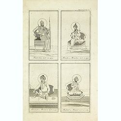
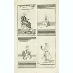
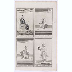
Jehan ou Jehon Gure, mort en 1627. / Gha Jehan ou Kourum, mort en 1665. / Oranzeb, mort en 1707. / Badour Siah, On ignore le tems de sa mort.
A striking and highly detailed copper engraved plate including 4 Indian Raja's Portraits. From Chatelain's 'Atlas Historique', 1732-1739. In upper right margin: 'Tom. V. ...
Date: Amsterdam, 1720
Selling price: ????
Please login to see price!
Sold in 2011
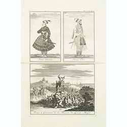
Jehan Darsiac. / Ferrog Sier. / Pompe & Ceremonie de la Marche du Grand Mogol.
From Chatelain's Atlas Historique, 1732-1739. In upper right margin: 'Tom. V. No 39. Pag: 110. Striking and highly detailed copper engraved plate including 2 Indian Raja'...
Date: Amsterdam, 1720
Selling price: ????
Please login to see price!
Sold in 2016
Tamberlan, mort en 1405. - Miracha ou Miraschae, mort en 1451. - Mohamed ou Miramont mort en 1451. - Abuchaid ou Abuzaid mort en 1469.
Striking and highly detailed copper engraved plate including 4 Indian princes or kings. From Chatelain's Atlas Historique, 1732-1739. In upper right margin: 'Tom. V. Nro ...
Date: Amsterdam, 1720
Selling price: ????
Please login to see price!
Sold in 2014
Sek ou Seich Omar, mort en 1493. Babar ou Baber ou Babour, mort en 1530. Amayum ou Houmayon, mort en 1552. Akebar ou Xa Aguebar, mort en 1605.
Striking and highly detailed copper engraved plate including 4 Indian princes or kings. From Chatelain's Atlas Historique, 1732-1739. In upper right margin: 'Tom. V. No 3...
Date: Amsterdam, 1720
Selling price: ????
Please login to see price!
Sold in 2014
A chart of the Western Part of the East-Indies with all the Adjacent Islands from Cape Bona Esperanca to the Island od Zelone.
This scarce sea of the Indian Ocean from the Cape of Good Hope to the west coast of India (Malabar). First issued by John Seller, the present example published by Mount ...
Date: London, Mount & Page, ca. 1720
Selling price: ????
Please login to see price!
Sold in 2015
Vue et description de Surate et de Batavia.
In top a panoramic view of Surat, a port city in India previously known as Suryapur, with Dutch ships in the foreground. In bottom a plan of Jakarta (Batavia, 100 x 125mm...
Date: Amsterdam, 1720
Selling price: ????
Please login to see price!
Sold in 2022
![[Four engravings showing People from India]](/uploads/cache/39592-250x250.jpg)
[Four engravings showing People from India]
Interesting sheet with four illustrations of different activities of people from India, from Chatelain's monumental 7 volume Atlas Historique. In upper right margin: 'Tom...
Date: Amsterdam, ca. 1720
Selling price: ????
Please login to see price!
Sold in 2017
Sek ou Seich Omar, mort en 1493. Babar ou Baber ou Babour, mort en 1530. Amayum ou Houmayon, mort en 1552. Akebar ou Xa Aguebar, mort en 1605.
Striking and highly detailed copper engraved plate including 4 Indian Princes or Kings. From Chatelain's "Atlas Historique", 1732-1739. In upper right margin: '...
Date: Amsterdam, 1720
Selling price: ????
Please login to see price!
Sold in 2018
Carte de l'Isle de Ceylan.
A detailed map of Sri Lanka with soundings and two large title cartouches. Engraved by Charles Amadeus de Berey, an engraver active in Paris. Dated 1722 at the bottom of ...
Date: Paris, 1722
Selling price: ????
Please login to see price!
Sold in 2018
Carte de l'Isle de Ceylan..
Detailed map of Sri Lanka with soundings and two large title cartouches. Engraved by Charles Amadeus de Berey, an engraver active in Paris. Dated 1700.
Date: Paris 1723
Selling price: ????
Please login to see price!
Sold
Carte de l'Isle de Ceylan..
Engraved by Charles Amadeus de Berey, an engraver active in Paris. Detailed map of Shri Lanka with soundings and two large title cartouches.
Date: Paris 1723
Selling price: ????
Please login to see price!
Sold
Carte des Cotes de Malabar et de Coromandel..
Detailed and attractive map of India and the northern tip of Sri Lanka. With decorative title cartouche and two compass-roses.
Date: Paris, 1723
Selling price: ????
Please login to see price!
Sold in 2011
Carte des Cotes de Malabar et de Coromandel..
An early issue of this detailed and attractive map of India and the northern tip of Sri Lanka. With decorative title cartouche and two compass-roses.Engraved by Marin.
Date: Paris 1723
Selling price: ????
Please login to see price!
Sold
Carte des Cotes de Malabar et de Coromandel. . .
Detailed and attractive map of India and the northern tip of Sri Lanka. With decorative title cartouche and two compass-roses. Engraved by Martin.Interestingly; during th...
Date: Paris, 1723
Selling price: ????
Please login to see price!
Sold in 2015
Carte des Cotes de Malabar et de Coromandel.
A striking map of southern India and Northern Ceylon, that extends to the Maldive Islands, and the northern tip of Sri Lanka. Cities, trade routes and topography are deta...
Date: Paris, 1723
Selling price: ????
Please login to see price!
Sold in 2018
Carte des Cotes de Malabar et de Coromandel..
Detailed and attractive map of India and the northern tip of Sri Lanka. Prepared by G. de l'Isle and published in Amsterdam. With decorative title cartouche and two compa...
Date: Amsterdam, 1723
Selling price: ????
Please login to see price!
Sold in 2020
Nieuwe Kaart van het Eyland Ceylon opgestelt door..
Fine chart depicting the Island of Ceylon/Sri Lanka.Good interior detail is given with settlements, roads, etc. An attractive early map, one of the few early very detaile...
Date: Amsterdam 1724
Selling price: ????
Please login to see price!
Sold
Nieuwe Kaart van Choromandel ende Malabar..
Fine map depicting the southern part of India and the northern tip of Ceylon. Much detail is given along the coastlines, settlements and principal coastal features are id...
Date: Amsterdam 1724
Selling price: ????
Please login to see price!
Sold
Nieuwe Kaart van Choromandel ende Malabar..
Fine map depicting the southern part of India and the northern tip of Ceylon. Much detail is given along the coastlines, settlements and principal coastal features are id...
Date: Amsterdam, 1724
Selling price: ????
Please login to see price!
Sold in 2015
Baye de Matecalo Dans l'Isle de Ceylon / Partie du Golfe de Bengale. ( Tome 2 Page 417)
Uncommon map of the Bay of Matecalo on Ceylon in the Gulf of Bengal. From the French reissue of the account of early Dutch voyages first published in 1608 by Commelin. Th...
Date: Amsterdam, F. Bernard, 1725
Selling price: ????
Please login to see price!
Sold in 2022
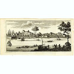
Cranganor.
This view of Cranganor in the state of Kerala in southwestern India. From the French reissue of the account of early Dutch voyages first published in 1608 by Commelin. Th...
Date: Amsterdam, F. Bernard, 1725
Selling price: ????
Please login to see price!
Sold in 2019
De Rivier van Suratta.
"Decorative map of the river Soeratta north of Bombay.Françcois Valentijn (1666-1727), a missionary, worked at Amboina from 1684 to 1694 and 1705 to 1713 ...
Date: Amsterdam 1726
Selling price: ????
Please login to see price!
Sold
![Malabar pars.. [no title]](/uploads/cache/15928-250x250.jpg)
Malabar pars.. [no title]
"Decorative map of the southern tip of the islands of Malabar.Françcois Valentijn (1666-1727), a missionary, worked at Amboina from 1684 to 1694 and 1705 ...
Date: Amsterdam 1726
Selling price: ????
Please login to see price!
Sold
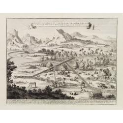
De Eliphants-Jagt gedaan in't Jaar 1717 inde Alutcoer Corle..
An informative print showing a place where elephants are kept and trained. Engraved by J.C.Philips.François Valentijn (1666-1727), a missionary, worked at Amboina from 1...
Date: Amsterdam 1726
Selling price: ????
Please login to see price!
Sold
De stadt Dabul.
Decorative panoramic view of the town of Dabul. Dutch (V.O.C.) sailing ships and various local craft fill the foreground. The city with great detail including the fort an...
Date: Amsterdam, 1726
Selling price: ????
Please login to see price!
Sold
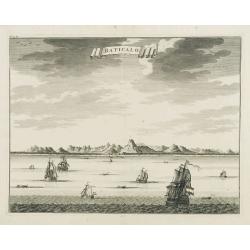
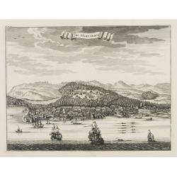
Baticalo.
Decorative panoramic view of the town of Baticalo on Ceylon. Dutch (V.O.C.) sailing ships and various local craft fill the foreground. The city with great detail includin...
Date: Amsterdam, 1726
Selling price: ????
Please login to see price!
Sold
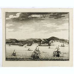
Cananor.
A view from the sea of the town of Cananoor on the Malabar coast. Dutch (V.O.C.) sailing ships and various local craft fill the foreground, the fortifications and buildin...
Date: Amsterdam, 1726
Selling price: ????
Please login to see price!
Sold in 2018
De Kusten van Guzaratte, Malabaar, Bengale en Malacca met die van't Magtig Koninkryk Siam totaan China bestevend.
A fine detailed map centered on India, also including the Malaysian pen insular. With charming pictorial title piece lower center, with a man and his servant, a temple an...
Date: Leiden, 1727
Selling price: ????
Please login to see price!
Sold in 2017
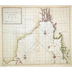
A Chart of the Coast of Cormandel and the great Bay of B..
A nicely engraved sea chart of the eastern coast of India, Burma's west coast and the island of Andaman. The map makes use of the new projection by Dr. Edmond Halley. Nic...
Date: London, ca. 1728
Selling price: ????
Please login to see price!
Sold
L'Inde de ça le Gange ..
Detailed map of India, with part of Sri Lanka. Decorative cartouche lower left.Although not renowned for the originality of his work, Pieter van der Aa is highly thought ...
Date: Amsterdam 1728
Selling price: ????
Please login to see price!
Sold

Baay van Tricoen Male.
From Francois Valentyn's "Oud en Nieuw Oost Indien', part V : Beschryving van Coromandel, Pegu, Arrakan, Bengale, Mocha,? Persien... Malakka.. Sumatra... Ceylon.&quo...
Date: Amsterdam, 1728
Selling price: ????
Please login to see price!
Sold
