Browse Listings in America > South America
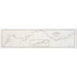
Plan of the Rivers Ucayali and Amazon from the Mission of Sarayacu to the Rio Negro, from the Observations of Lieut W.m Smyth & Mr Fred.k Lowe.
Copperplate engraved map of the Amazon, engraved by John Walker. Published by John Murray, Albemarle Street, London.Smyth and Lowe of the Royal Navy followed the Amazon i...
Date: London 1836
Selling price: ????
Please login to see price!
Sold
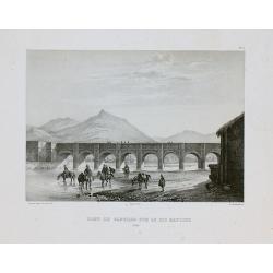
Pont de Santiago sur le Rio Mapocho.
Drawn by V. Adam and engraved by Benard and Frey. From Bougainville's "Journal de la navigation autour du globe de la fregate la Thetis et de la corvette l'Esperance...
Date: Paris, 1837
Selling price: ????
Please login to see price!
Sold in 2011
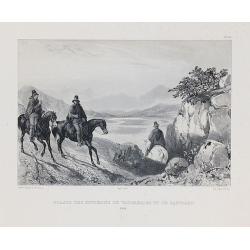
Guasos des environs de Valparaiso et de Santiago.
Drawn by V. Adam and engraved by Benard and Frey. From Bougainville's "Journal de la navigation autour du globe de la fregate la Thetis et de la corvette l'Esperance...
Date: Paris, 1837
Selling price: ????
Please login to see price!
Sold in 2010
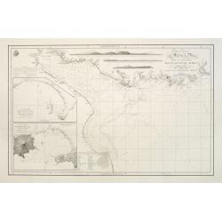
Carta esférica del Rio de la Plata...
Large nautical chart.
Date: Madrid 1812-1838
Selling price: ????
Please login to see price!
Sold
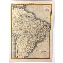
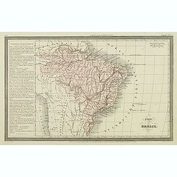
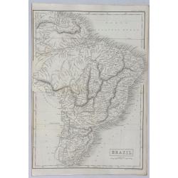
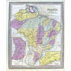
Carte du Bresil
A fine, detailed map of Brazil from Columbia to the Atlantic Ocean. The map also includes parts of the neighbouring countries of Chile, Peru and the Caribbean. Engraved b...
Date: Paris, 1838
Selling price: ????
Please login to see price!
Sold in 2016
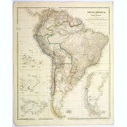
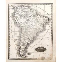
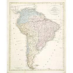
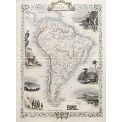
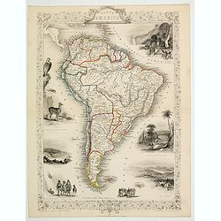
South America.
A striking steel engraved map of South America, with large, uncolored inset maps of The Galapagos Islands, Port San Carlos, Falkland Islands, and Patagonia. A tremendous ...
Date: London, 1839
Selling price: ????
Please login to see price!
Sold in 2017
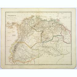
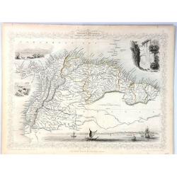
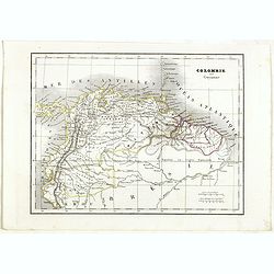
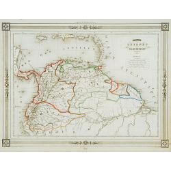
Colombia.
A large, detailed steel engraved map of the South American state of Colombia. This map of Colombia extends into modern day Venezuela to the east, and Ecuador to the south...
Date: London, 1839
Selling price: ????
Please login to see price!
Sold in 2020
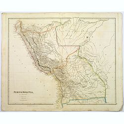
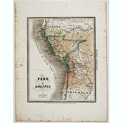
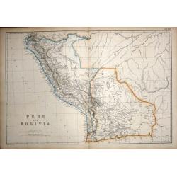
Peru & Bolivia.
A large, detailed steel engraved map of the South American states of Peru & Bolivia. Peru gained its independence from Spain in 1821. Bolivia was named after Simon Bo...
Date: London, 1839
Selling price: ????
Please login to see price!
Sold in 2017
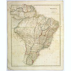
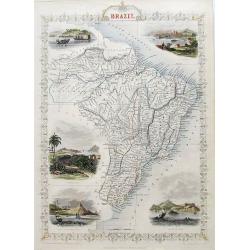
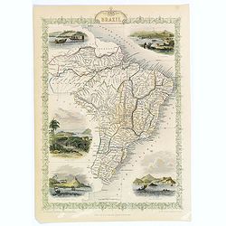
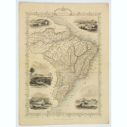
Brazil.
A large, detailed steel engraved map of the vast South American state of Brazil. The only Portuguese speaking colony in The Americas. It is the largest state in Latin and...
Date: London, 1839
Selling price: ????
Please login to see price!
Sold in 2017
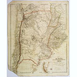
The Provinces of La Plata...and Chile.
A large, detailed steel engraved map of Chile and Argentina, together with Uruguay. Small inset map of Patagonia and Falkland Islands. Despite some map loss, the map is w...
Date: London, 1839
Selling price: ????
Please login to see price!
Sold in 2017
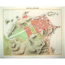
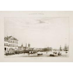
Rio de Janeiro
A handsome, seldom seen early 19th century plan of Rio de Janeiro and its famous bay. The map identifies the city's major thoroughfares, expanses and important points of ...
Date: Paris, ca. 1840
Selling price: ????
Please login to see price!
Sold in 2008
Confederazione del Chili, Stati Uniti Sulrio Plata, dittatorato del Paraguai, Repubblica Orientale dell'Urugai.
A rare and detailed double-page map of Chili, Paraguay and Uruguay. The map is surrounded by an explanatory historical text about the countries in green, yellow and pink ...
Date: Venice, 1840
Selling price: ????
Please login to see price!
Sold in 2019
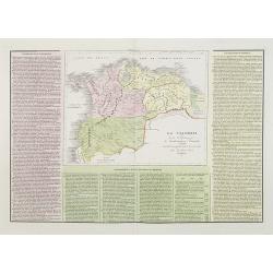
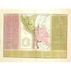
La Colombia . . .
A rare and detailed double-page map of Colombia, Bolivia and Venezuela. The map is surrounded by an explanatory historical text about the countries in pink, yellow and gr...
Date: Venice, 1840
Selling price: ????
Please login to see price!
Sold in 2011
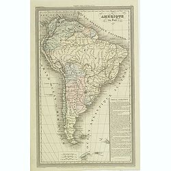
Amerique du sud.
Finely engraved map of South America, prepared by A.H.Dufour and engraved by Giraldon-Bovinet. Published by Jules Renouard in his uncommon atlas "Le globe Atlas clas...
Date: Paris, Jules Renouard, ca.1840
Selling price: ????
Please login to see price!
Sold
Empire du Brésil.
Finely engraved map prepared by A.H.Dufour and engraved by Giraldon-Bovinet. Published by Jules Renouard in his uncommon atlas "Le globe Atlas classique Universel de...
Date: Paris, Jules Renouard, ca.1840
Selling price: ????
Please login to see price!
Sold in 2012
South America.
Pleasing map featuring "South America". Engraved by G. Boynton and published in Boston by Samuel Walker in about 1840.
Date: Boston, c1840
Selling price: ????
Please login to see price!
Sold in 2014
Le Due Repubbliche cioe La Confederazione Peruvian et Bolivia.
A rare, detailed map of Peru and Bolivia. The map is surrounded by explanatory historical text. Tasso's map was prepared by J.A. Buchon and A de la Sage for "L'ATLAN...
Date: Venice, 1840
Selling price: ????
Please login to see price!
Sold in 2017
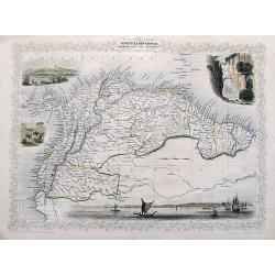
Venezuela, New Granada, Ecuador and the Guayanas
A map of the northern countries of South America including Venezuela, New Granada, Ecuador and The Guayanas.With four decorative vignettes showing Paramaribo, Fall of Bag...
Date: London, 1841
Selling price: ????
Please login to see price!
Sold in 2018
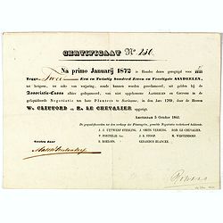
Certificaat N° 230
Text reads "Na primo januarij 1872 is houder dezes geregtigd voor 2/2147 tot hetgeen, ter zake van verjariing, zoude kunnen worden gereclmeerd, uiy gelden bij de Ass...
Date: Amsterdam, 1841
Selling price: ????
Please login to see price!
Sold in 2026
Plan de la Baie de Rio-Janeiro..
A detailed chart of the Rio de Janeiro bay with towns, buildings, banks, isles and soundings made in brasses a French measure of depth of water corresponding to the fatho...
Date: Paris [1829] 1843
Selling price: ????
Please login to see price!
Sold in 2008
18 plates taken from <I>Rio de Janeiro Pitoresco.</I>
Group of 18 very rare lithographes made Heaton e Rensburg active in Rio de Janeiro. Edited by L. Buvelot after design of Auguste Moreau. Originating from RIO DE JANEIRO P...
Date: Rio de Janeiro 1845
Selling price: ????
Please login to see price!
Sold
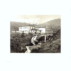
Fazenda du Secretario.. .Manicipe de Vassouras.
Scare lithograph of Fazenda du Secretario. Lithographed by Jacottet. After a photograph of Victor Frond.
Date: Paris, ca. 1845
Selling price: ????
Please login to see price!
Sold in 2015
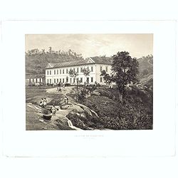
Fazenda du Secretario Manicipe de Vassouras.
Scare lithograph of Fazenda du Secretario. Lithographed by Jacottet. After a photograph of Victor Frond.
Date: Paris, 1845
Selling price: ????
Please login to see price!
Sold in 2015
Colombie et Guyanne.
Detailed map of Colombia and Guyana / Surinam, prepared by Charles V. Monin (fl.1830-1880) a French cartographer of Caen and Paris. Published in Atlas Universel de Géogr...
Date: Paris, 1845
Selling price: ????
Please login to see price!
Sold in 2019
Colombie et Guyanes..
Decorative map of Colombia, Venezuela, Surinam, prepared by J.G.Barbié du Bocage.Engraved by Ch.Smith, published by Basset who was established in Paris, rue de Seine 33....
Date: Paris 1846
Selling price: ????
Please login to see price!
Sold
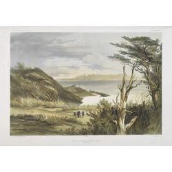
Vue des environs de Port Famine (Detroit de Magellan)
Exquisite contemporary colored lithograph of Port Famine in most southern part of South America, with Dumont D'Urville's officers hunting. Drawn by Ernest Goupil (died 18...
Date: Paris, 1846
Selling price: ????
Please login to see price!
Sold in 2010
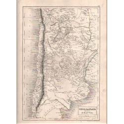
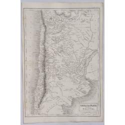
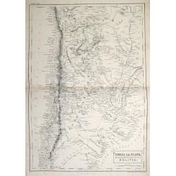
Chili, La Plata and Part of Bolivia.
Sidney Hall's map of Chili published in London by Adam & Charles Black.
Date: London, 1846
Selling price: ????
Please login to see price!
Sold in 2018
Brazil.
A detailed map of Brazil in South America from Adam & Charles Black, who were among the leading publishers of atlases and travel books in the 19th Century in England....
Date: London, 1846
Selling price: ????
Please login to see price!
Sold in 2021
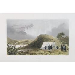
Observatoire de Port Famine. (Detroit de Magellan)
Exquisite contemporary colored lithograph of the Port Famine, situated in the southern tip of America, with Dumont D'Urville's officers discussing in front of a tenth. Dr...
Date: Paris, 1848
Selling price: ????
Please login to see price!
Sold in 2017
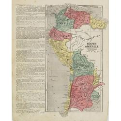
Karta öfver Södra America.
An very rare map of South America with Swedish text. The map is dated 1825. In upper right corner Suppl. 2.From his atlas "Geographisk Hand-Atlas" first publish...
Date: A. Wiborgs förlag, Stockholm, ca. 1848
Selling price: ????
Please login to see price!
Sold in 2014
Chili, La Plata and Part of Bolivia.
A detailed map of South America from Adam & Charles Black who were among the leading publishers of atlases and travel books in the 19th Century in England. Engraved b...
Date: Edinbourgh, 1849
Selling price: ????
Please login to see price!
Sold in 2021
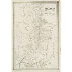
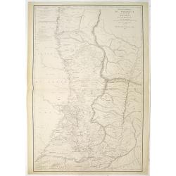
Charte von Paraguay entworfen von Dr. J.R.Rengger.
Detailed map of Paraguay. Lithographed by father and son Engelmann.
Date: Mulhouse 1850
Selling price: ????
Please login to see price!
Sold
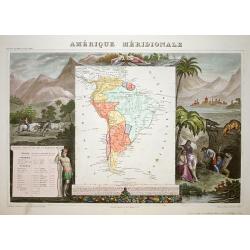
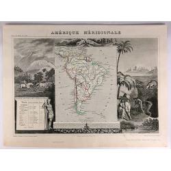
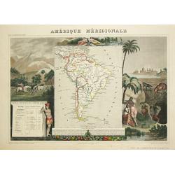
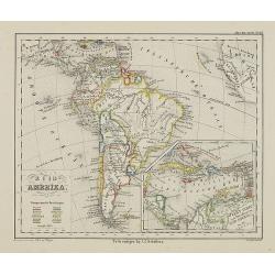
Amerique Meridionale.
A very decorative 19th century map of the continent colored to show political divisions. The map is surrounded by fully colored, steel engraved scenes including horses, I...
Date: Paris 1850
Selling price: ????
Please login to see price!
Sold
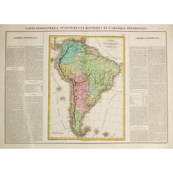
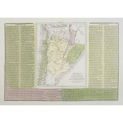
Carte Géographique, Statistique et Historique de l'Amerique Meridionale.
A fine, detailed map of South America with on both sides explanetary text.From "J.A. Buchon Atlas Gégraphique Statistique, historique et chronologique des deux Amé...
Date: Paris, 1850
Selling price: ????
Please login to see price!
Sold in 2016
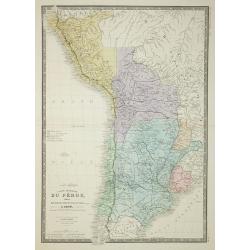
Carte Generale du Perou de la Bolivie, du Chili, et la Plata.
Map of the western part of South America, from Atlas Universel De Geographie Physique, Politique, Ancienne Et Moderne …, published by Ch. Delagrave.
Date: Paris, 1850
Selling price: ????
Please login to see price!
Sold in 2011
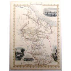
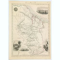
British Guayana.
Pleasing map of British Guyana with four fine lithographed vignettes of scenes from Guyana. It was drawn and engraved by J. Rapkin and published in London by John Tallis ...
Date: London, 1850
Selling price: ????
Please login to see price!
Sold in 2016
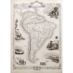
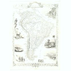
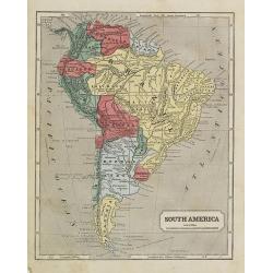
South America.
A detailed map of South America from the famous Atlas by John Tallis. With many place names, regions, and countries shown.Highly decorative map with ornamental borders, s...
Date: London, ca 1850
Selling price: ????
Please login to see price!
Sold in 2017
Brazil
A very decorative steel-engraved map of Brazil, highly detailed with place names, rivers, hills, bays, etc. Attractively illustrated with vignette style views of "Bo...
Date: London, ca 1850
Selling price: ????
Please login to see price!
Sold in 2017
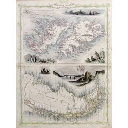
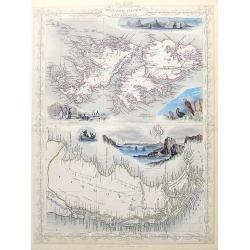
Falkland Islands and Patagonia.
Two very decorative steel-engraved maps on one sheet. Both maps are very detailed with place names, rivers, hills, islands, bays, etc.Attractively illustrated with vignet...
Date: London, ca.1850
Selling price: ????
Please login to see price!
Sold in 2017
Peru & Bolivia
A very decorative steel-engraved map extending from Guayaquil southwards until the Atacama. Very detailed with place names, rivers, hills, bays, etc.Attractively illustra...
Date: London, ca.1850
Selling price: ????
Please login to see price!
Sold in 2017
South America.
A detailed map of South America from the famous atlas by John Tallis. With many place names, regions, and countries shown. A highly decorative map with ornamental borders...
Date: London, ca. 1850
Selling price: ????
Please login to see price!
Sold in 2017
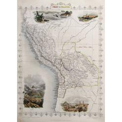
Peru & Bolivia.
A very decorative steel-engraved map extending from Guayaquil southwards until the Atacama. Very detailed with place names, rivers, hills, bays, etc.Attractively illustra...
Date: London, ca. 1850
Selling price: ????
Please login to see price!
Sold in 2018
Falkland Islands and Patagonia.
Two very decorative steel-engraved maps on one sheet. Both maps are very detailed with place names, rivers, hills, islands, bays, etc.Attractively illustrated with vignet...
Date: London, ca. 1850
Selling price: ????
Please login to see price!
Sold in 2020
Venezuela, New Granada, Equador, and The Guayanas.
A highly decorative steel-engraved map from Panama to French Guayana. Very detailed with place names, rivers, hills, bays, etc. Attractively illustrated with vignette sty...
Date: London, ca. 1850
Selling price: ????
Please login to see price!
Sold in 2018
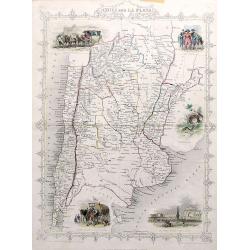
Chili and La Plata.
A very decorative steel-engraved map extending from the border of Bolivia until Patagonia, with northern Chile and northern Argentina. Very detailed with place names, riv...
Date: London, ca. 1850
Selling price: ????
Please login to see price!
Sold in 2017
Chile, La Plata or the Argentine Republic and Bolivia.
A fine example of Adam and Charles Black's 1851 map of Chile, the Argentine Republic and part of Bolivia. The map illustrates Bolivia's claims to the Atacama Desert and a...
Date: Edinburgh, 1851
Selling price: ????
Please login to see price!
Sold in 2013
South America.
This is John Tallis’ pretty map of South America. The map is surrounded by a number of topical steel engraved vignettes and the whole is surrounded by a decorative vine...
Date: London, 1851
Selling price: ????
Please login to see price!
Sold in 2016
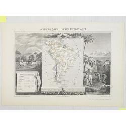
Amerique Meridionale.
A decorative map of South America showing political divisions in color. The map is surrounded by steel engraved scenes including horses, Indians, jaguars, tapirs, mining ...
Date: Paris, 1851
Selling price: ????
Please login to see price!
Sold in 2018
Brazil.
A highly decorative and detailed map of Brazil which was drawn and engraved by J. Rapkin (vignettes by H. Winkles & W. Lacey ). Showing Boats on Lake Negro, Monte Vid...
Date: London, Edinburgh & Dublin 1851
Selling price: ????
Please login to see price!
Sold in 2020
Carte d'une partie des Cotes Orientales de L'Amerique Meridionales. . .
A large marine chart of the eastern coast of Argentina, from the mouth of the River Plate, south to the Gulf of St. George. Filled with nautical information depth levels,...
Date: Paris, 1851
Selling price: ????
Please login to see price!
Sold in 2019
Brazil.
A highly decorative and detailed map of Brazil which was drawn and engraved by J. Rapkin (vignettes by H. Winkles & W. Lacey ). Showing Boats on Lake Negro, Monte Vid...
Date: London, Edinburgh & Dublin 1851
Selling price: ????
Please login to see price!
Sold in 2021
South America.
This is John Tallis’ pretty map of South America. The map is surrounded by a number of topical steel engraved vignettes and the whole is surrounded by a decorative vine...
Date: London, 1851
Selling price: ????
Please login to see price!
Sold in 2023
Amerique Meridionale.
A decorative map of South America from levasseur's 'Atlas national Illustre des 86 Departements et des possesions de la France'.
Date: Paris, 1852
Selling price: ????
Please login to see price!
Sold
Amérique Méridionale.
Map of South America.Lovely map from one of the last decorative atlases of the nineteenth century.The rather simple map is framed by horses, Indians, jaguars, tapirs, and...
Date: Paris, A. Combette, 1852
Selling price: ????
Please login to see price!
Sold in 2009
Sud America.
A lovely large map of South America, nicely colored by the newly formed independent countries, with a legend and mileage scales. With good map detail and competently engr...
Date: Weimar, ca 1852
Selling price: ????
Please login to see price!
Sold in 2020
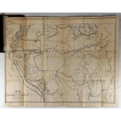
Map of the Valley of the Amazon To Accompany Lt. Herndon's Report.
This is one of three maps that accompanied Herndon's report, “Exploration of the Valley of the Amazon”. In 1851, Lieutenant Herndon was commissioned to lead the first...
Date: Baltimore, 1853
Selling price: ????
Please login to see price!
Sold in 2018
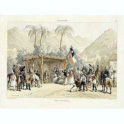
Historia de Chile. No. 20. Una chingana.
From "Historia de Chile." by Claudio Gay, a French naturalist, who was working under contract to the Chilean government between 1830-1833. Upon his return to Fr...
Date: Paris, 1854
Selling price: ????
Please login to see price!
Sold in 2014
Brazil.
A fine map of Brazil, from Guiana and Venezuela in the north to Uruguay and Buenos Aires in the south. Filled with places names and also some reference to Indians. Two in...
Date: Philadelphia, 1854
Selling price: ????
Please login to see price!
Sold in 2020
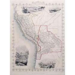
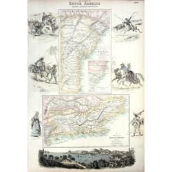
West Coast of South America including Chile & part of Bolivia & Peru.
A decorative regional map of South America, which contains 4 maps. The top map shows Peru and the neighboring Bolivian Table Lands, while and the 3 maps at the bottom dep...
Date: Edinburgh, 1854
Selling price: ????
Please login to see price!
Sold in 2020
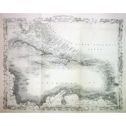
West India Islands.
This is the uncommon and slightly later edition by Rapkin based on Tallis' maps. The vignettes have been removed and the map is issued in black and white. The map extends...
Date: London 1855
Selling price: ????
Please login to see price!
Sold
South America western part.
Map of western part of South America. From Sidney E. Morse''s: System of Geography for the use of schools , published by Harper and brothers, 329 Pearl Street, New York.A...
Date: New York, 1855
Selling price: ????
Please login to see price!
Sold in 2009
South America.
Map of the South American continent. From Sidney E. Morse''s: System of Geography for the use of schools , published by Harper and brothers, 329 Pearl Street, New York.An...
Date: New York, 1855
Selling price: ????
Please login to see price!
Sold in 2009
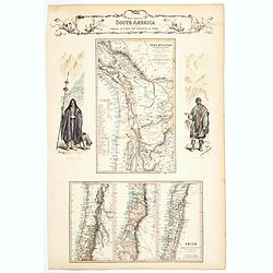
Carte des côtes du Chili et de la Bolivie dressée d'après les Traveux du Cap.e Fitz-Roy par Robiquet . . .
Large chart of the coast of Chili, with 11 detailed insets. Engraved by Louis A. Sengteller.
Date: Paris, 1857
Selling price: ????
Please login to see price!
Sold in 2012
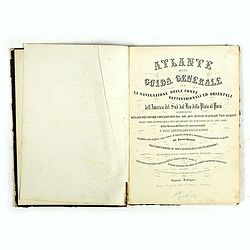
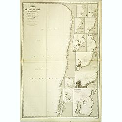
Atlante della Guida generale per la navigazione delle coste settentrionali ed orientali dell' America de Sud dal Rio della Plata al Parà...
A good example of the first edition, extra illustrated. The Atlante is a rare and important collection of lithographed charts, plans, and city views of the Atlantic coast...
Date: Naples, Caro Batelli, 1857
Selling price: ????
Please login to see price!
Sold in 2018
Peru e Bolivia.
Uncommon map of Peru and Bolivia prepared by Francesco Costantino Marmocchi. Above the map "Geografia Commerciale". From "Il Globo Atlante di carte Geograf...
Date: Genova, Paolo Rivara fu Giacomo, 1858
Selling price: ????
Please login to see price!
Sold in 2020
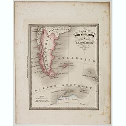
Le Terre Magellanighe e Le Antartiche.
Uncommon map of Patagonia and part of Antarctica, prepared by Francesco Costantino Marmocchi. Above the map "Geografia Commerciale". From "Il Globo Atlante...
Date: Genova, Paolo Rivara fu Giacomo, 1858
Selling price: ????
Please login to see price!
Sold in 2022
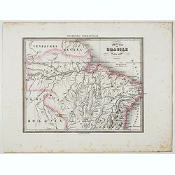
Impero del Brasile Parte Nord.
Uncommon map of Brazil northside prepared by Francesco Costantino Marmocchi. Above the map "Geografia Commerciale". From "Il Globo Atlante di carte Geograf...
Date: Genova, Paolo Rivara fu Giacomo, 1858
Selling price: ????
Please login to see price!
Sold in 2022
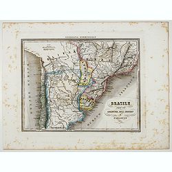
Brasile Parte Sud Argentina, Chili, Uruguay e Paraguay.
Uncommon map of Brasile Southside, Argentina, Chili, Uruguay and Paraguay. northside prepared by Francesco Costantino Marmocchi. Above the map "Geografia Commerciale...
Date: Genova, Paolo Rivara fu Giacomo, 1858
Selling price: ????
Please login to see price!
Sold in 2022
British Guayana.
A decorative steel engraved map of British Guyana. The last Tallis map of the region, published circa 1858 by The London Printing and Publishing Company (the partnership ...
Date: London, 1858
Selling price: ????
Please login to see price!
Sold in 2020
Zuid Amerika.
Uncommon map of South America. Lithography by J.H. van Weijer, published in Atlas der geheele Aarde [?] in 24 kaarten. With colored key to English, French, Dutch, Spanish...
Date: Groningen, ca. 1860
Selling price: ????
Please login to see price!
Sold in 2012
Peru and Bolivia.
Published by Blackie & Son Glasgow Edinburgh & London 1860. This highly detailed map of the area comes from "The Imperial Atlas of Modern Geography". Po...
Date: Glasgow Edinburgh & London, 1860
Selling price: ????
Please login to see price!
Sold in 2015
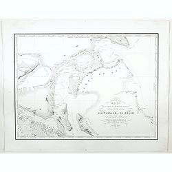
Carte de la partie du Detroit de Magellan reconnue par les Corvettes L'Astrolabe et La Zelee. . .
A detailed map of the Straits of Magellan, prepared by Vincendon Dumoulin after a visit of the ships L'Astrolabe and La Zelee in the year 1841. From Voyage au Pole Sud et...
Date: Paris, 1860
Selling price: ????
Please login to see price!
Sold in 2023
Amerique du Sud Spheroidale.
"Very detailed map from ""Atlas Sphérodïdal & Universel de géographie"", Prepared by F.A.Garnier and edited by Jules Renouard, rue de Tour...
Date: Paris, 1861
Selling price: ????
Please login to see price!
Sold in 2021
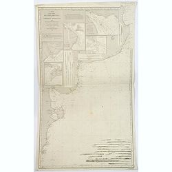
EAST COAST OF SOUTH AMERICA; BRAZIL, MIDDLE PROVINCES
Excellent lithograph published by Fullarton. Shows two maps of Brazil: "East Coast of Brazil" & "Province of Rio de Janeiro" both by H.Mahlmann a...
Date: London, Edinburgh, Dublin, c.1861
Selling price: ????
Please login to see price!
Sold
Carte de la République du Paraguay (cours du Parana et du Paraquay) . . .
Large, detailed and rare map of Paraguay prepared by Ernest Amédée Barthélemy Mouchez. According to the title the information was gathered during his voyages in 1857 -...
Date: Paris, Logerot, 1862
Selling price: ????
Please login to see price!
Sold
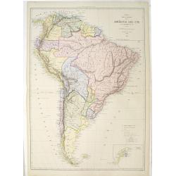
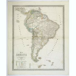
Mapa fisica y politica de la América del Sur. . .
Large and uncommon lithographed map of South America prepared by A.Vuillemin and A.Logerot and printed by Gratia. Most names in Spanish. In lower right corner an inset ma...
Date: Paris, A.Logerot / F.Brachet, 1867
Selling price: ????
Please login to see price!
Sold in 2011
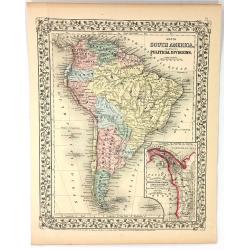
Map of South America Showing its Political Divisions
A pleasing map of South America, with attention to both political and geographical elements. Complete with inset of the Atrato-Inter-Oceanic Canal Routes. The map is sur...
Date: Philadelphia, 1867
Selling price: ????
Please login to see price!
Sold in 2016
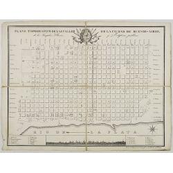
Plano Topografico de las Calles de la Ciudade de Buenos-Aires. . .
Folding-map of Buenos Aires Inset of the city sky line with a key map.
Date: ca. 1870
Selling price: ????
Please login to see price!
Sold in 2008
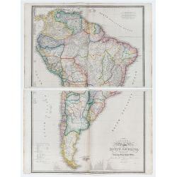
Colombia Prima or South America drawn from the large map in eight sheets by Louis Stanislav D'Arcy Delarochette.
2 large double page engraved maps (each 53 x 76 cm overall sheet 56 x 86 and if joined combining to make an overall sheet size of c.110 x 86 cm) with original outline col...
Date: London: James Wyld. Geographer toHer Majesty Charing Cross East. 1870
Selling price: ????
Please login to see price!
Sold in 2020
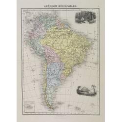
Amérique Méridionale.
Decorative map of South America from Géographie Universelle, Atlas Migeon. With an inset map of the Galapagos Islands. Published by J. Migeon. Engraved by Sengteller.Fro...
Date: Paris, 1874
Selling price: ????
Please login to see price!
Sold in 2022
