Browse Listings in America > South America > Peru
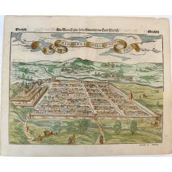
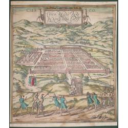
Der Statt Cusco / so die fuernembste im Land Peru / Il Cuscho Citta Principale della Provincia del Peru.
An early woodcut view of Cusco (Cuzco) in Peru by Sebastian Munster on a full double sheet. One of the earliest views of a city in the 'New World'. Verso an early woodcut...
Date: Basel, H.Petri, ca. 1550
Selling price: ????
Please login to see price!
Sold in 2019
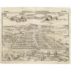
Il Cuscho citta principale della provincia del Peru.
A very desirable item of this decorative and early bid's-eye view of the Inca city of Cuzco, based on Braun & Hogenberg's depiction of the city. Several figures shown...
Date: Basle, 1555
Selling price: ????
Please login to see price!
Sold
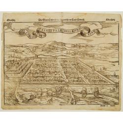
Il Cuscho citta principale della provincia del Peru.
A very desirable item of this decorative and early bid's-eye view of the Inca city of Cuzco, based on Antoine du Pinet's depiction of the city. Several figures shown insi...
Date: Basle 1555
Selling price: ????
Please login to see price!
Sold
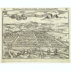
Il Cuscho citta principale della provincia del Peru.
A very desirable and scarce item of this decorative and early bid's-eye town-plan of the Inca city of Cuzco. Several figures shown inside the city walls and on the hillsi...
Date: Lyons, 1564
Selling price: ????
Please login to see price!
Sold in 2012
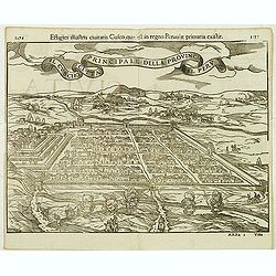
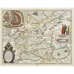
Cusco, Regni Peru in Novo Orbe Caput.
According to George Braun : "The capital of Peru in the south of the New world is Cusco, a city so large, powerful and beautiful that it can easily rank alongside th...
Date: Antwerp, 1572
Selling price: ????
Please login to see price!
Sold in 2014
Principale della provincia citta del peru il cuscho.
On recto an early birds-eye view of Cusco. On verso tittle page and a plan of Mexico City "Urbs themistiana hispaniae" (165x162mm.)From a German text edition of...
Date: Basle, 1550-1590
Selling price: ????
Please login to see price!
Sold in 2014
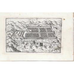
Cusco
Miniature town view of the City of Cuzco, Peru, with figures in the foreground Valegio signature at the lower edge of the plate. It was published as part of a series of b...
Date: Venice, 1595
Selling price: ????
Please login to see price!
Sold in 2016
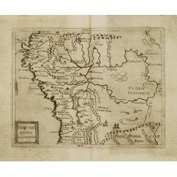
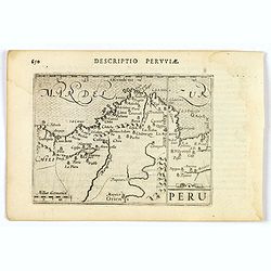
Peruani Regni Discriptio.
Very rare sixteenth century map of Peru.Published in the German edition of José de Acosta's De Natura Nova Orbis, first published in Salamanca, 1588. Acosta was a Spanis...
Date: Cologne 1598
Selling price: ????
Please login to see price!
Sold
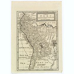
Peru.
An attractive miniature map of Peru, with north orientated to the right, published by Petrus Bertius in Amsterdam at the turn of the seventeenth century. Some interior i...
Date: Amsterdam, 1606
Selling price: ????
Please login to see price!
Sold in 2023
![Cusco urbs nobilissima & opule[n]tissima Peruani regni in occide[n]tali parte. . .](/uploads/cache/37010-250x250.jpg)
Cusco urbs nobilissima & opule[n]tissima Peruani regni in occide[n]tali parte. . .
Famous town plan of Cuzco, from the first German edition of part VI of de Bry's " Grands Voyages". In this work the conquest of Peu by Pizarro was discribed. Th...
Date: Frankfurt, 1607
Selling price: ????
Please login to see price!
Sold in 2024
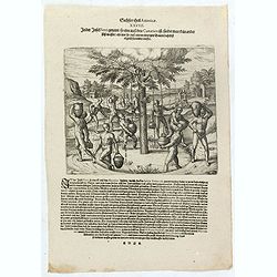
In der Insel Ferri genandt so eine auss den Canarien ist findet man kein ander süss wasser als nur so auss einem eintzigen Baum daselbst täglich herunder trieffet.
Natives of the Canary islands collect water falling from the leaves of a tree. Includes dwellings, vessels, and clouds over the tree. Text page with copper engraving page...
Date: Frankfurt, 1607
Selling price: ????
Please login to see price!
Sold in 2020
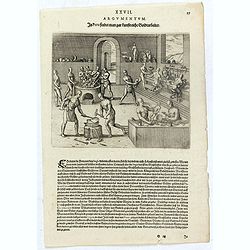
In Peru findet man gar kunstreiche Goldtarbeiter.
Native American method of working gold and silver. Men blow through reeds over a hearth, furnace, or foundry. Other men pound metal with hammers. Other men work the metal...
Date: Frankfurt, 1607
Selling price: ????
Please login to see price!
Sold in 2023
Wie herrlich die Fürsten und Fürstliche Diener in den Occidentalischen Indien zur Erden bestattet werden.
Native Americans bury a chief or king with food, golden vessels, and jewelry. Includes feathered garments and fortifications. The funeral of an Inca king was a ceremony o...
Date: Frankfurt, 1607
Selling price: ????
Please login to see price!
Sold in 2023
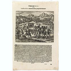
Das sechste Theil der nieuwen Welt oder Der Historien Hieron. Benzo von Meylandt. . .
Conflict between Gonzalo Pizarro and the latest officially appointed governor of Peru, Pedro de la Gasca, reached a climax in 1548 when Gasca’s forces crossed the Apuri...
Date: Frankfurt, 1607
Selling price: ????
Please login to see price!
Sold in 2023
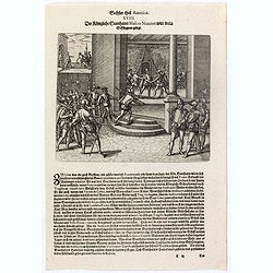
Der Königliche Statthalter Blascus Nunnez Vella wird in ein Gefängnuss gelegt.
This stabbing caused so much resentment among the people of Lima that the new governor, Blanco Núñez Vela, eventually decided he would be safer to transfer his offices ...
Date: Frankfurt, 1607
Selling price: ????
Please login to see price!
Sold in 2023
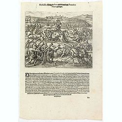
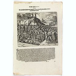
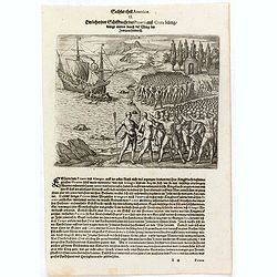
Atabaliba König in Peru wirdt von dem Francisco Pizarro gefangen.
The Inca king, Atahualpa or Atabaliba, holding a scepter in the shape of the sun, is carried on a litter into a scene of warfare. A priest or monk with a crucifix approac...
Date: Frankfurt, 1607
Selling price: ????
Please login to see price!
Sold in 2023
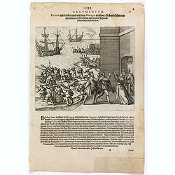
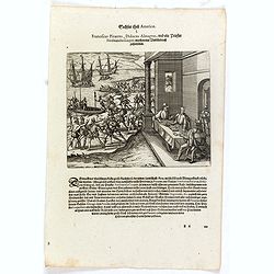
Pizzarus wird widerumb mit dem Almagro versönet sie beyde schweren zusammen dass sie trewlich bey einander stehn und halten wöllen biss in den Todt.
Francisco Pizarro and Pedro de Almagro swear an oath on the Host held by the priest, Hernando de Luque. The men stand in front of fortifications while ships are loaded by...
Date: Frankfurt, 1607
Selling price: ????
Please login to see price!
Sold in 2016
Ein behertzter Schiffknecht dess Pizarri auss Creta bürtig drengt mitten durch die Meng de. . .
In 1528 Pizarro set out on a voyage of true exploration in search of the civilization and riches of Peru, about which he had heard so much from the Indians of Panama. Whe...
Date: Frankfurt, 1607
Selling price: ????
Please login to see price!
Sold in 2023
Franciscus Pizarrus, Didocus Almagrus, und ein Priester Ferdinandus Luques machen eine Verbündnuss zusammen.
Francisco Pizarro, Diego de Almagro, and the priest, Hernando de Luque, negotiate a contract while men load cargo onto boats and ships. Includes dwellings, casks, swords,...
Date: Frankfurt, 1607
Selling price: ????
Please login to see price!
Sold in 2023
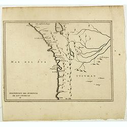
Descripcion Del Audiencia De los Charcas (Chile, Bolivia, Peru)
The earliest map to include information from the previously secret manuscript maps of the Spanish cosmographer, Juan López de Velasco, showing the Audiencia of the New K...
Date: Amsterdam, Michel Colin, 1622
Selling price: ????
Please login to see price!
Sold in 2017
Peru.
Rare first state. Decorated with ships and monsters on the sea. Orientated with east at the top. A most decorative item. One of the most dramatic events in the early hist...
Date: Amsterdam 1629
Selling price: ????
Please login to see price!
Sold
![[Incas lay siege to Cusco.]](/uploads/cache/40353-250x250.jpg)
[Incas lay siege to Cusco.]
Atahualpa’s brother, Manco, organized a long and bloody siege to reoccupy the Inca capital, which eventually spread to open rebellion throughout the land. Pizarro, who ...
Date: Frankfurt, M.Merian, 1633
Selling price: ????
Please login to see price!
Sold in 2025
![Guame. [Spilbergen's fleet reaches Huarmey] / Payta [Spilbergen's fleet reach Paita].](/uploads/cache/41088-250x250.jpg)
Guame. [Spilbergen's fleet reaches Huarmey] / Payta [Spilbergen's fleet reach Paita].
Two engravings. [500] The town of Huarmey was situated about 150 miles north of Lima. It was conveniently located for ships because there was a natural harbour nearby wit...
Date: Frankfurt, M.Merian, 1633
Selling price: ????
Please login to see price!
Sold in 2021
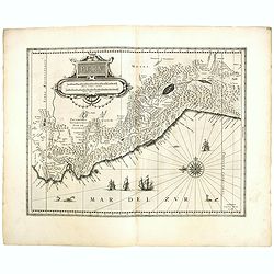
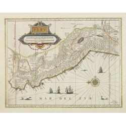
Peru.
FIRST EDITION, FIRST ISSUE OF THIS MAP. Decorated with ships and monsters in the sea. Orientated with east at the top. With the signature of G. Blaeuw lower right corner....
Date: Amsterdam, 1634
Selling price: ????
Please login to see price!
Sold
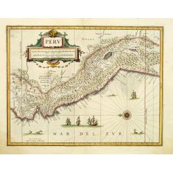
Peru.
Decorated with ships and monsters on the sea. Orientated with east at the top. A most attractive item.
Date: Amsterdam 1635
Selling price: ????
Please login to see price!
Sold
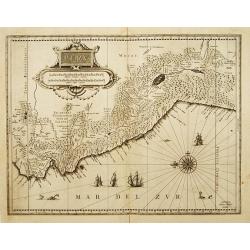
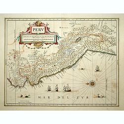
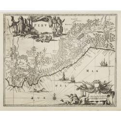
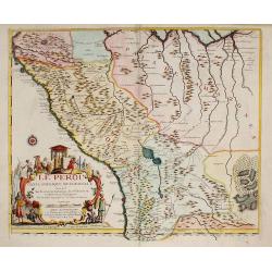
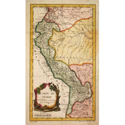
PERU.
Decorative map of Peru, shows the Pacific coast of South America from Ecuador (at the left-hand side) as far south as the Atacama desert in the northern reaches of Chile....
Date: Amsterdam 1635
Selling price: ????
Please login to see price!
Sold
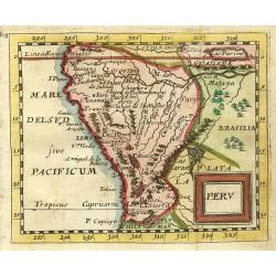
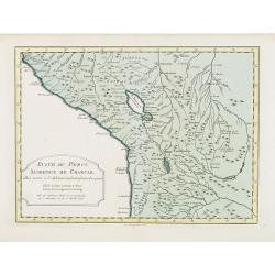
Peru.
French text edition. A map of Peru, orientated with north to the left, also showing most of Equador and Northern Chile, also includes Potosi, the famous mountain of silve...
Date: Amsterdam, 1645
Selling price: ????
Please login to see price!
Sold in 2018
Peru.
Decorative map of Peru, featuring large decorative cartouche, compass rose, four sailing ships and three sea monsters. East to the top. Nearly 100 place names shown.
Date: Amsterdam, c. 1645
Selling price: ????
Please login to see price!
Sold in 2012
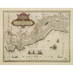
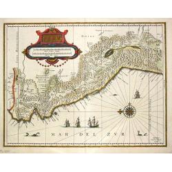
Peru.
Decorated with ships and monsters in the sea. Orientated with east at the top. With the signature of G. Blaeuw lower right corner. Shows the Pacific coast of South Americ...
Date: Amsterdam, 1650
Selling price: ????
Please login to see price!
Sold in 2013
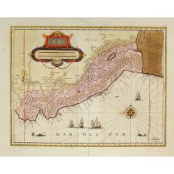
Peru.
Johan Blaeu succeeded his father Willem when the latter died in 1638. Johan led the Blaeu firm to its greatest achievement the ' Atlas Maior' in 12 parts, the greatest an...
Date: Amsterdam, c. 1650
Selling price: ????
Please login to see price!
Sold in 2020
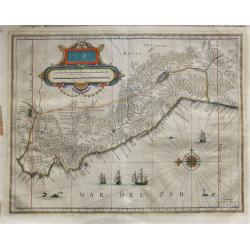
Peru.
First edition of the last part of the Latin "Atlas maior" dedicated to America.Decorated with ships and monsters on the sea. Orientated with east at the top. A ...
Date: Amsterdam, 1662
Selling price: ????
Please login to see price!
Sold in 2009
Peru.
Map of Peru from De Nieuwe en onbekende Weereld.. published by Arnold Montanus, which was used by John Ogilby as the basis of his Complete History of America.The map exte...
Date: Amsterdam, 1671
Selling price: ????
Please login to see price!
Sold
Peru.
"Nice miniature map covering the region from the Equator to the Tropic of Capricorn. At upper right corner in Brazil 'Lac Parime"" with the golden city 'Ma...
Date: Paris 1679
Selling price: ????
Please login to see price!
Sold
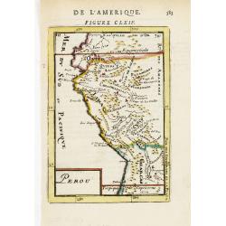
Perou.
Interesting map of Peru with the capital, Lima, in the centre.From the French text edition of Description d'Univers, 1683. by Allain Manneson Mallet (1630-1706), a well t...
Date: Paris, 1683
Selling price: ????
Please login to see price!
Sold
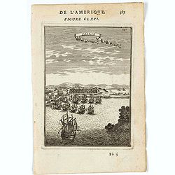
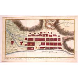
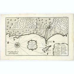
Callao.
A charming print of the fortified town and port of El Callao in Peru. Spanish and Dutch ships in the bay, engaged in battle.El Callao was founded by Spanish colonists in ...
Date: Paris, 1683
Selling price: ????
Please login to see price!
Sold in 2022
Perou.
Interesting map of Peru with the capital, Lima, in the centre.From the French text edition of Description d'Univers, 1683. by Allain Manneson Mallet (1630-1706), a well t...
Date: Paris 1683
Selling price: ????
Please login to see price!
Sold
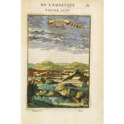
Cusco.
Charming view of the Peruvian town of Cuzco. From the French text edition of Description d'Univers, 1683. by Allain Manneson Mallet (1630-1706), a well travelled military...
Date: Paris 1683
Selling price: ????
Please login to see price!
Sold
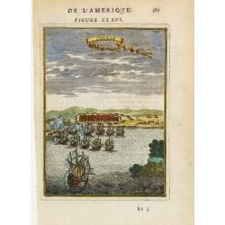
Callao.
Bird's-eye view of the fortified sea town of Callao, besieged by fighting ships.From the French text edition of Description d'Univers, 1683. by Allain Manneson Mallet (16...
Date: Paris 1683
Selling price: ????
Please login to see price!
Sold
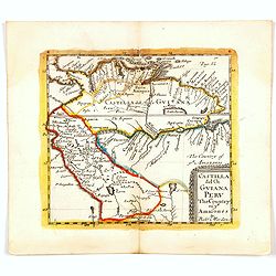
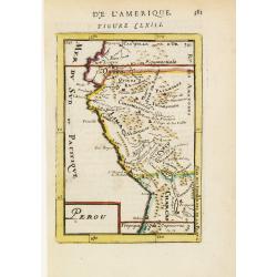
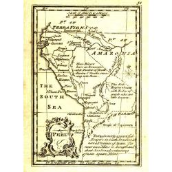
Castilla del Or Guiana Peru The Country of the Amazones.
A delightful small map of Peru and northern most portion of South America, into what is now north western Brazil. Showing and naming many of the large number of rivers th...
Date: London, 1688
Selling price: ????
Please login to see price!
Sold in 2020
Peru ou Perou.
Charming map of Peru. Including some of the territory of today Equador on the north and extending southwards as far as the Atacama desert in Chile. Decorated with a large...
Date: Amsterdam 1700
Selling price: ????
Please login to see price!
Sold
A Map of Peru and the West Part of the Country of the Amazones.
A map showing a good proportion of the west coast of South America, covering Peru, Chile, Western Brazil and Quito (Equador). Many coastal settlements and towns are engra...
Date: London, 1711
Selling price: ????
Please login to see price!
Sold in 2019
LE PEROU Dans l'Amérique Méridionale ?
Map of Peru including parts of present-day Ecuador, Bolivia, and Brazil. Cartographic elements include location of native American settlements, rivers, lakes, and wetland...
Date: Paris, 1719
Selling price: ????
Please login to see price!
Sold in 2009
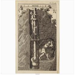
Mine.
Interesting print illustrating the entrance of a mine and part of a tunnel. It was mend to describe the hard labour to which the native Peruvian were forced.From "Vo...
Date: Amsterdam, 1722
Selling price: ????
Please login to see price!
Sold in 2020
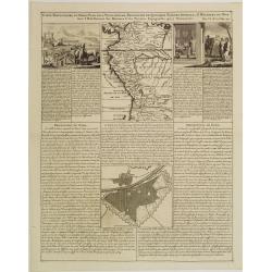
Carte Particuliere du Perou, Plan de la Ville de Lima, Description de Quelques Plantes, Animaux, &..
An interesting folio sheet containing two maps and two engravings with panels of French text. The top map covers the Northwest coast of South America from Panama to north...
Date: Amsterdam 1728
Selling price: ????
Please login to see price!
Sold
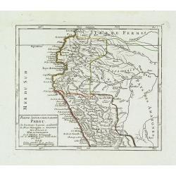
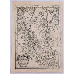
Partie Septentrionale du Perou. . .
Detailed small map encompassing the Ecuadorian seacoasts and the Peruvian shores as far as Lima.In the hinterland the first stretch of the River Amazon. From Atlas Portat...
Date: Paris, later than 1748
Selling price: ????
Please login to see price!
Sold in 2018
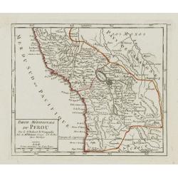
Partie Méridionale du Perou.
Detailed small map encompassing southern Peru, Bolivia and part of Chile. Centered on the lake Titicaca. Including the Atacama desert.From Atlas Portatif Universel, by Ro...
Date: Paris, later than 1748
Selling price: ????
Please login to see price!
Sold in 2017
![[9 maps of Peru and Chili]](/uploads/cache/20641-(1)-250x250.jpg)
[9 maps of Peru and Chili]
A map of the Southamerican continent from the Dutch edition of Robertson's ' History of America'.Plus 8 maps of Peru and Chili
Date: London, ca. 1750
Selling price: ????
Please login to see price!
Sold in 2022
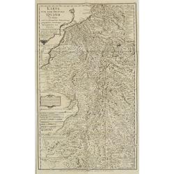
KARTE von der Provinz Quito in Peru. . . N°8.
Detailed map of Peru. In: Allgemeine Historie der Reisen zur Wasser und zu Lande: oder Sammlung aller Reisebeschreibungen.. in Englischen zusammen getragen, und aus demse...
Date: Leipzig, 1753
Selling price: ????
Please login to see price!
Sold in 2009
![Carte de la Meridiene mesurée au ROYAUME DE QUITO. . . [Karte von der Gemessenen Mittagslinie in dem Koenigreiche Quito. . .]](/uploads/cache/26172-250x250.jpg)
Carte de la Meridiene mesurée au ROYAUME DE QUITO. . . [Karte von der Gemessenen Mittagslinie in dem Koenigreiche Quito. . .]
A detailed map of Quito region, prepared in 1744. In: Allgemeine Historie der Reisen zur Wasser und zu Lande: oder Sammlung aller Reisebeschreibungen.. in Englischen zusa...
Date: Leipzig, 1753
Selling price: ????
Please login to see price!
Sold in 2009
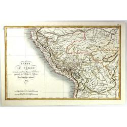
Carte du Pérou.
Jaques Nicolas Bellin (1702-720) was the most important French hydrographer of the 18th century. Sea-atlas 'Hydrographique Français' , 1756-65, atlas to accompany Prévo...
Date: Paris, c. 1755
Selling price: ????
Please login to see price!
Sold
Suite de Perou Audience de Charcas.
Uncommon edition of this accurate map showing the southern Peruvian coast, the ranges and villages of numerous Indian tribes are shown.FromAtlas Portatif pour servir a l'...
Date: Amsterdam, 1756
Selling price: ????
Please login to see price!
Sold in 2020
Plan de la Ville de Paita dans le Roiaume de Santa Fe.
Plan of the Peruvian city of Paita on the Santa Fe coast. The original map was produced by Captain George Anson during his voyage around the world. Jacob Van Der Schley...
Date: Amsterdam, 1765
Selling price: ????
Please login to see price!
Sold in 2013
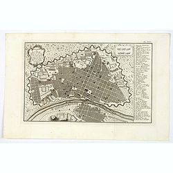
Platte-Grond van Lima Hoofdstadt van Peru. . .
An attractive plan of the Peruvian capital of Lima. From a Dutch edition of an important report of a French/Dutch expedition through South America in 1772. The map depict...
Date: Amsterdam, ca 1772
Selling price: ????
Please login to see price!
Sold in 2023
De Haven van Callao in de Stille of Zuid-Zee. . .
An attractive plan of the Peruvian port of Callao, and her surrounds, including Lima, some 15 km's to the east. From a Dutch edition of an important report of a French/Du...
Date: Amsterdam, ca 1772
Selling price: ????
Please login to see price!
Sold in 2019
Missiion des Moxes Etablie par les PP de la Comp'e de Jesus dans le Perou.
A fine detailed map of Peru showing the topographical locations and details of the many Jesuit missions. It features an attractive title cartouche.
Date: Paris, 1780
Selling price: ????
Please login to see price!
Sold in 2017
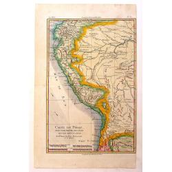
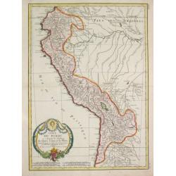
Carte du Perou avec Une Partie des Pays Qui en Sont a L'Est
An interesting map of Peru with the "Country of Amazon" on it Eastern border. From "Atlas de Toutes les Parties Connues du Globe Terrestre". Detailed ...
Date: Paris, 1780
Selling price: ????
Please login to see price!
Sold in 2014
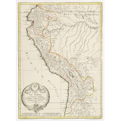
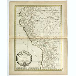
Carte du Perou ou se trouvent les Audiences de Quito, Lima et la Plata..
Attractive map centered on Peru, covering the northern half of the South American Pacific coast, from Ecuador to northern Chili.Boundaries outlined in hand color. Large o...
Date: Paris ca 1783
Selling price: ????
Please login to see price!
Sold
Carte Carte du Perou ou se trouvent les Audiences de Quito, Lima et la Plata.
Jean Lattré, Paris-based engraver and publisher. Worked with Robert de Vaugondy, J. Janvier and R. Bonne. " Atlas Monderne', 1771, 1783 , 1793. Rigobert Bonne (1727...
Date: Paris, 1783
Selling price: ????
Please login to see price!
Sold in 2019
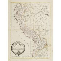
Carte du Perou ou se trouvent les audiences de Quito, Lima et la Plata . .
Attractive map of Peru, ornated with a decorative title cartouche. Boundaries outlined in hand color.Prepared by Le Sieur Janvier, Jean Denis [Robert], French geographer ...
Date: Paris, ca 1783
Selling price: ????
Please login to see price!
Sold in 2019
Carte du Perou ou se trouvent les Audiences de Quito, Lima et la Plata..
Attractive map centered on Peru, covering the northern half of the South American Pacific coast, from Ecuador to northern Chili.Boundaries outlined in hand color. Large o...
Date: Paris, ca 1783
Selling price: ????
Please login to see price!
Sold in 2012
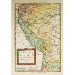
Kaart van Peru, Met een gedeelte van de Landen ten oosten gelegen.
Willem Albert Bachiene (1712-1783), Dutch geographer in Maastricht. Most important work ' Heilige Geographie', a work on the Holy Land. Mathijs Schalenkamp published in 1...
Date: Amsterdam, 1785
Selling price: ????
Please login to see price!
Sold in 2008
Peru.
Uncommon miniature map from Gibson's "Atlas Minimus, or a New Set of Pocket Maps of the several Empires, Kingdoms and States of the known World".
Date: London, 1792
Selling price: ????
Please login to see price!
Sold
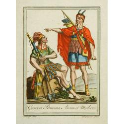
Guerriers Peruviens, Ancien et Moderne.
Hand-colored mezzotints of Native Americans drawn by Labrousse and engraved by Laroque after Jacques Grasset de Saint-Sauveur.
Date: Paris,1796
Selling price: ????
Please login to see price!
Sold in 2010
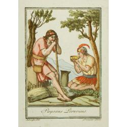
Paysans Peruviens.
Hand-colored mezzotints of Native Americans drawn by Labrousse and engraved by Laroque after Jacques Grasset de Saint-Sauveur.
Date: Paris,1796
Selling price: ????
Please login to see price!
Sold in 2010
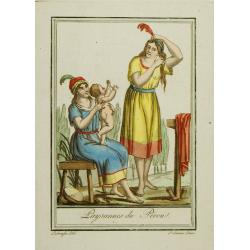
Paysannes du Pérou.
Hand-colored mezzotints of Native Americans drawn by Labrousse and engraved by Laroque after Jacques Grasset de Saint-Sauveur.
Date: Paris,1796
Selling price: ????
Please login to see price!
Sold in 2010
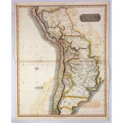
Peru, Chili and La Plata.
A fine 1817 Thomson map of Peru, Chile and Argentina. It also covers parts of Bolivia, Paraguay, Uruguay and Brazil. The map identifies towns, rivers, mountains, indigeno...
Date: Edinbourgh, 1817
Selling price: ????
Please login to see price!
Sold in 2021
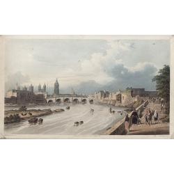
LIMA, por el Lado del este.
Very fine view of Lima, engraved by T.Sutherland. The engraving was made after a design of Paroissein.Showing the Rímac River and is the most important source of potable...
Date: London, 1820
Selling price: ????
Please login to see price!
Sold in 2008
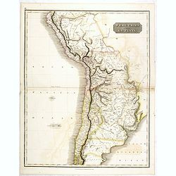
Peru, Chili and La Plata.
This is a beautiful 1817 Thomson map of Peru, Chile and Argentina. It covers Bolivia, Paraguay, Uruguay and parts of Peru, Chile, Argentina and Brazil.The map identifies ...
Date: Edinburgh, 1821
Selling price: ????
Please login to see price!
Sold in 2016
Carte du Perou Dressee pouo L'intelligence de L'histoire generale des Voyages de Labarpe.
A striking lithograph map of Peru and the surrounding countries. One of the original maps that shows the findings resulting from the voyages of Labarpe.
Date: Paris , 1821
Selling price: ????
Please login to see price!
Sold in 2017
Peru.
This is the map of Peru is from a plano edition of the very scarce German edition of Carey & Lea's "A Complete Historical, Chronological, and Geographical Americ...
Date: Weimar, 1822-1825
Selling price: ????
Please login to see price!
Sold
![[Human sacrifices by Peruvian Indians ].](/uploads/cache/27281-250x250.jpg)
[Human sacrifices by Peruvian Indians ].
Aquatint depicting human sacrifices by Peruvian Indians. Engraved by Gallina.From Giulio Ferrario's work Le Costume Ancien et Moderne ou Histoire du gouvernement, de la m...
Date: Milan, 1827
Selling price: ????
Please login to see price!
Sold in 2016
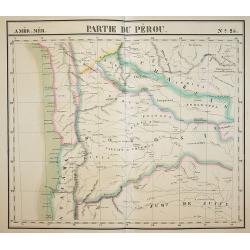
Partie du Pérou. N:25.
One map of a series of four composing a map of Peru. Map covering southern part of Peru, from his famous Atlas Universel . This atlas was one of the most remarkable world...
Date: Brussels, 1825-1827
Selling price: ????
Please login to see price!
Sold in 2011
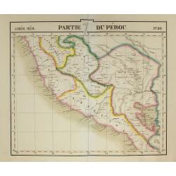
Partie du Pérou. N:20.
One map of a series of four composing a map of Peru. Map covering western part of Peru, from his famous Atlas Universel . This atlas was one of the most remarkable world ...
Date: Brussels, 1825-1827
Selling price: ????
Please login to see price!
Sold in 2011
![[Peruvian Indian artifacts ].](/uploads/cache/27287-250x250.jpg)
[Peruvian Indian artifacts ].
Aquatint depicting Peruvian artifacts.From Giulio Ferrario's work Le Costume Ancien et Moderne ou Histoire du gouvernement, de la milice, de la religion, des arts, scienc...
Date: Milan, 1827
Selling price: ????
Please login to see price!
Sold in 2020
![[Inca marriage ceremony ].](/uploads/cache/27286-250x250.jpg)
[Inca marriage ceremony ].
Aquatint depicting an Inca marriage ceremony in Peru.Engraved by Gallina.From Giulio Ferrario's work Le Costume Ancien et Moderne ou Histoire du gouvernement, de la milic...
Date: Milan, 1827
Selling price: ????
Please login to see price!
Sold in 2009
![[ Sun Rock Ravine in Peru ]](/uploads/cache/27285-250x250.jpg)
[ Sun Rock Ravine in Peru ]
Aquatint depicting the Sun Rock Ravine in Peru.Engraved by Fumagalli.From Giulio Ferrario's work Le Costume Ancien et Moderne ou Histoire du gouvernement, de la milice, d...
Date: Milan, 1827
Selling price: ????
Please login to see price!
Sold in 2009
![[ Scene of the eclipse of the moon ].](/uploads/cache/27284-250x250.jpg)
[ Scene of the eclipse of the moon ].
Aquatint depicting Peruvian warship by the eclipse of the moon. Mama Quilla (Mama Quilla) was the Inca Pre-Columbian, South American, mother moon goddess who helped to re...
Date: Milan, 1827
Selling price: ????
Please login to see price!
Sold in 2009
![[ Mayta Capac granting clemency ].](/uploads/cache/27283-250x250.jpg)
[ Mayta Capac granting clemency ].
Aquatint depicting the Inca ruler "Mayta Capa" granting clemency.Engraved by Fumagalli.From Giulio Ferrario's work Le Costume Ancien et Moderne ou Histoire du g...
Date: Milan, 1827
Selling price: ????
Please login to see price!
Sold in 2009
![[ Alparo ].](/uploads/cache/27280-250x250.jpg)
[ Alparo ].
Aquatint depicting an alparo, a sort of llama.Engraved by Raineri.From Giulio Ferrario's work Le Costume Ancien et Moderne ou Histoire du gouvernement, de la milice, de l...
Date: Milan, 1827
Selling price: ????
Please login to see price!
Sold in 2009
![[ Atahuallpa defeat ].](/uploads/cache/27279-250x250.jpg)
[ Atahuallpa defeat ].
Aquatint depicting Atahuallpa's (also called Atabalipa's defeat).Atahuallpa, Atabalipa (b. Cusco - d. Cajamarca, August 29, 1533), was the last sovereign emperor of the T...
Date: Milan, 1827
Selling price: ????
Please login to see price!
Sold in 2009
