Browse Listings in America > North America > Virginia / Maryland / Carolina / Georgia
![[de Lafayette, full-length portrait] Conclusion de la campagne -- de 1781 en Virginie Liberté : To his Excellency General Washington this Likeness of his friend, the Marquess de la Fayette, is humbly dedicated, By le Mire. . .](/uploads/cache/36866-250x250.jpg)
[de Lafayette, full-length portrait] Conclusion de la campagne -- de 1781 en Virginie Liberté : To his Excellency General Washington this Likeness of his friend, the Marquess de la Fayette, is humbly dedicated, By le Mire. . .
Print shows Marquis de Lafayette, full-length portrait, standing, facing front, wearing a uniform, and holding two swords in the left hand while directing American troops...
Date: Paris, 1780 - 1790
Selling price: ????
Please login to see price!
Sold in 2016
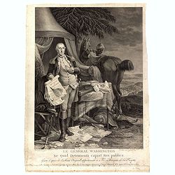
Le Général Washington ne quid detrimenti capiat res publica - gravé d'après le tableau original appartenant a Mr. Marquis de la Fayette. . .
Print shows George Washington, full-length portrait, standing outside tent, wearing military uniform, holding the Declaration of Independence and the treaty of alliance w...
Date: Paris, 1780 - 1790
Selling price: ????
Please login to see price!
Sold in 2016
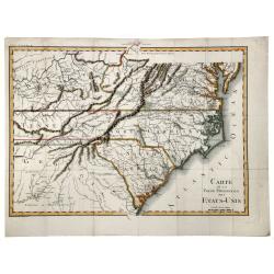
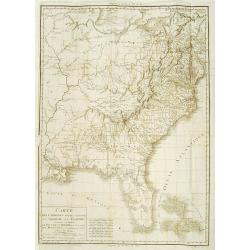
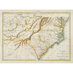
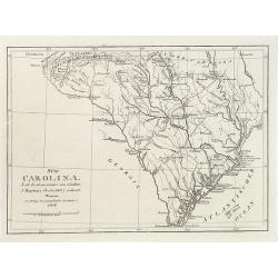
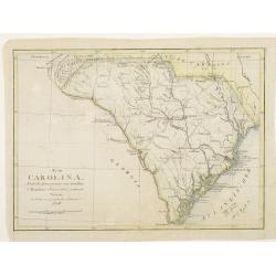
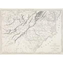
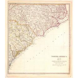
CARTE de la Partie Meridionale des ETATS-UNIS.
A nice example of this scarce and highly detailed map of the southern United States, showing excellent topography, roadways, and a great many place names and Indian tribe...
Date: Paris, 1790
Selling price: ????
Please login to see price!
Sold in 2019
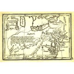
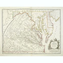
Pensilvania, Maryland and Virginia.
Uncommon miniature map from Gibson's "Atlas Minimus, or a New Set of Pocket Maps of the several Empires, Kingdoms and States of the known World".
Date: London, 1792
Selling price: ????
Please login to see price!
Sold in 2011
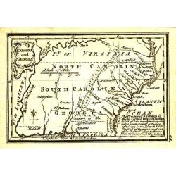
Carolina and Georgia.
Uncommon miniature map from Gibson's "Atlas Minimus, or a New Set of Pocket Maps of the several Empires, Kingdoms and States of the known World".
Date: London, 1792
Selling price: ????
Please login to see price!
Sold in 2011
Carte De La Virginie Et Du Maryland Dressee sur la grande carte Angloise de Mrs. Josue Fry et Pierre Jefferson . . . 1755
A state five (of 5). Showing pre-revolutionary war Virginia and Maryland, extending west to the Alleghany Mountains, and including Delaware and a portion of New Jersey, ...
Date: Paris, ca.1793
Selling price: ????
Please login to see price!
Sold in 2013
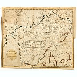
Map of the State of Kentucky with the Adjoining Territory By J. Russell 1794.
Important early map of Kentucky, showing primarily the region around the Ohio and Tennessee Rivers, from northern Georgia to Western Territory. Prepared by John Russell (...
Date: London, H.D. Symonds, 1794
Selling price: ????
Please login to see price!
Sold
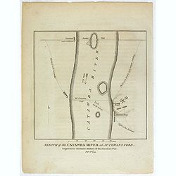
Sketch of the Catawba River at McCowan's Ford. . .
Revolutionary War battle plan, showing Lord Cornwallis' march and crossing of the Catawba River at McCown's Ford (now Cowan's Ford), and on towards Salisbury, along with ...
Date: London, 1794
Selling price: ????
Please login to see price!
Sold in 2018
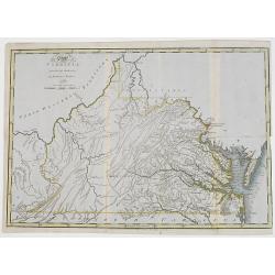
The State of Virginia from the best authorities, by Samuel Lewis. 1794.
Very detailed map of Virginia, prepared by Samuel Lewis.Engraved by Smithier and included in Carey's American Edition of Gurthries Geography.Underneath the map "engr...
Date: Philadelphia, Mathew Carey, 1795
Selling price: ????
Please login to see price!
Sold
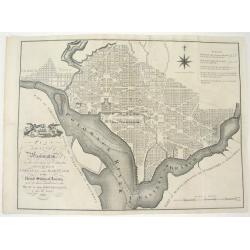
PLAN OF THE CITY OF WASHINGTON, IN THE TERRITORY OF COLUMBIA...
An important and very rare, state one example of the first British printing of Washington D.C. The plan derives from John Reid's, The American Atlas. The source for both...
Date: London, 1795
Selling price: ????
Please login to see price!
Sold
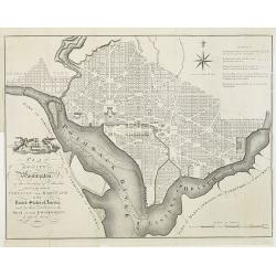
PLAN of the CITY of Washington, in the Territory of Columbia, ceded by the States of VIRGINIA AND MARYLAND to the United States of America, and by them established as the SEAT of their GOVERNMENT, after the YEAR 1800.
The famous 18th century plan of the Capital of Washington. This is the English issue of the official Thackara and Vallance plan, Philadelphia, 1792, which was made from L...
Date: London, 1795
Selling price: ????
Please login to see price!
Sold in 2009
Carte dés Carolines Méridionale et septrionale La Georgie, la Floride.. Le pays des Cherokées ..
Fine map of Florida, Carolinas and Georgia. From : Voyage dans les parties sud de l'Amérique septentrionale, savoir : les Carolines septentrionale et méridionale, la G�...
Date: Paris 1799
Selling price: ????
Please login to see price!
Sold
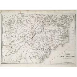
Carte des États-Unis, Provinces Méridionales.
The map shows portions of Kentucky, Virginia, Tennessee, Georgia, North Carolina, South Carolina, a strip of land between Tennessee and Georgia as 'United States Territor...
Date: Paris, 1799
Selling price: ????
Please login to see price!
Sold in 2022
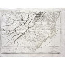
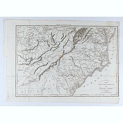
Carte de la partie méridionale des Etats-Unis.
Detailed map of North and South Carolina, Kentucky, Tennessee and Virginia. A separate publication of Pierre François Tardieu.With in lower left corner the address: Grav...
Date: Paris 1800
Selling price: ????
Please login to see price!
Sold
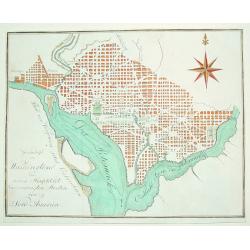
Grundrifs von Washington der nuen Hauptstadt ver vereinigten Staaten von Nord America
An extremely rare and desirable early plan of Washington DC. Of German origin, the map was published during Thomas Jefferson's first term as U.S. President. The work iden...
Date: Heidelberg, c. 1803
Selling price: ????
Please login to see price!
Sold

Homme et Femme de Virginie.
Hand-colored mezzotints of Native Americans engraved by Félix Mixelle and Lachaussée Jeune after Jacques Grasset de Saint-Sauveur.
Date: Paris,1801-1806
Selling price: ????
Please login to see price!
Sold in 2011
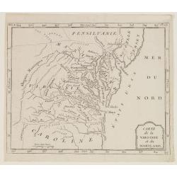
Carte de la Virginie et du Mariland.
Map centered on Chesapeake Bay and its hinterland, from Atlas de la Géographie de toutes les parties du monde.. Ouvrage destiné pour l'education, et nécessaire aux né...
Date: Paris, Prudhomme, Levrault, Debray, 1806
Selling price: ????
Please login to see price!
Sold in 2017
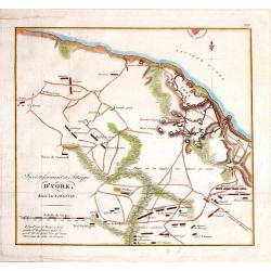
Investissment et Attaque D'York, dans la Virginie.
Engraved fold-out map from the French edition of John Marshall's "Life of George Washington". This historical map depicts Yorktown (the final engagement) and it...
Date: Paris, 1807
Selling price: ????
Please login to see price!
Sold in 2016
Süd Carolina. Nach des Gouverneurs von Carolina J. Dalton Charte (1803) reducirt. . .
Interesting map of South Carolina and its cartographic source, based on Governor Drayton's map of South Carolina of 1803. The map provides lots of details with many place...
Date: Weimar, Geographisches Institute, 1808
Selling price: ????
Please login to see price!
Sold in 2018
Süd Carolina. Nach des Gouverneurs von Carolina..
Map of South Carolina. Copied after a map by J.Drayton.
Date: Weimar, 1808
Selling price: ????
Please login to see price!
Sold
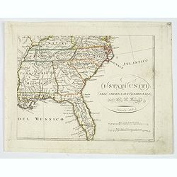
I Stati Uniti nell' America Settentrionale.
Only one sheet of four.The south eastern section of Bartolomeo Borghi's scarce 4 sheet map of the United States. From east of the Mississippi River. From: Kentucky and so...
Date: Firenze, 1818
Selling price: ????
Please login to see price!
Sold in 2019
Carta delle provincie meridionali degli Stati - Uniti
Interesting map from the Italian translation of Francois La Rochefoucauld-Liancourt's famous travel guide for the United States. Showing the Carolinas, Georgia, Tennessee...
Date: Italy, 1819
Selling price: ????
Please login to see price!
Sold in 2008
Carta delle provincie meridionali degli Stati - Uniti.
An interesting map from the Italian translation of Francois La Rochefoucauld-Liancourt's famous travel guide for the United States.Showing the Carolinas, Georgia, Tenness...
Date: Italy, 1819
Selling price: ????
Please login to see price!
Sold in 2023
Carta delle provincie meridionali degli Stati-Uniti.
An Italian map of the south eastern United States from Botta's Storia della Guerra dell' Independenza degli Stati Uniti d'America, which was based upon Francois la Rochef...
Date: Milan, ca 1819
Selling price: ????
Please login to see price!
Sold in 2020
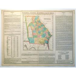
Geographical, Statistical and Historical Map of Georgia
Nice example of this fine map of Georgia, from the 1827 edition of Carey & Lea's Geographical, Statistical and Historical Atlas of America, with two columns of conte...
Date: Philadelphia, 1822
Selling price: ????
Please login to see price!
Sold in 2023
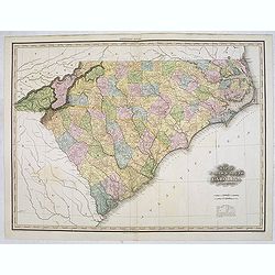
Map of North & South Carolina by H.S. Tanner.
Uncommon and important map of North and South Carolina by H.S. Tanner and published in his "New American Atlas" from 1823. Henry Schenck Tanner (1786-1858) was ...
Date: Philadelphia, Henry Tanner, 1823
Selling price: ????
Please login to see price!
Sold in 2014
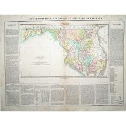
Carte Géographique .. du Maryland.
"Detailed map of Maryland. From J.A. Buchon, ""Atlas Gégraphique Statistique, historique et chronologique des deux Ameriques et des isles adjacentes; trad...
Date: Paris 1825
Selling price: ????
Please login to see price!
Sold
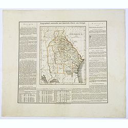
Geographisch-Statistische und Historische Charte von Georgia.
A nice map of the southern US state of Georgia, from the German version of Carey and Lea's English language atlas. This atlas was issued in six editions, from 1822-1827, ...
Date: Weimar, 1825
Selling price: ????
Please login to see price!
Sold in 2017
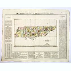
Carte Geographique, Statistique et Historique du Tennessee.
A nice detailed map of the state of Tennessee from Buchon's Atlas Gégraphique Statistique, historique et chronologique des deux Ameriques et des isles adjacentes traduit...
Date: Paris, 1825
Selling price: ????
Please login to see price!
Sold in 2019
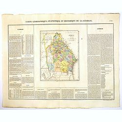
Carte Geographique, Statistique et Historique de la Georgie.
A nice detailed map of the state of Georgia from Buchon's Atlas Gégraphique Statistique, historique et chronologique des deux Ameriques et des isles adjacentes traduit d...
Date: Paris, 1825
Selling price: ????
Please login to see price!
Sold in 2022
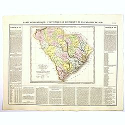
Carte Geographique, Statistique et Historique de la Caroline du Sud.
A nice detailed map of the state of South Carolina from Buchon's Atlas Gégraphique Statistique, historique et chronologique des deux Ameriques et des isles adjacentes tr...
Date: Paris, 1825
Selling price: ????
Please login to see price!
Sold in 2019
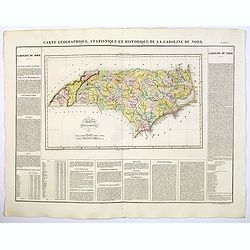
Carte Geographique, Statistique et Historique de la Caroline du Nord.
A nice detailed map of the state of North Carolina from Buchon's Atlas Gégraphique Statistique, historique et chronologique des deux Ameriques et des isles adjacentes tr...
Date: Paris, 1825
Selling price: ????
Please login to see price!
Sold in 2019

Carte Geographique, Statistique et Historique de la Virginie.
A nice detailed map of the state of Virginia from Buchon's Atlas Gégraphique Statistique, historique et chronologique des deux Ameriques et des isles adjacentes traduit ...
Date: Paris, 1825
Selling price: ????
Please login to see price!
Sold in 2020
![[ General Washington's House ].](/uploads/cache/27548-250x250.jpg)
[ General Washington's House ].
Aquatint depicting General Washington's House engraved by Fumagalli. Plate N°47.From Giulio Ferrario's work Le Costume Ancien et Moderne ou Histoire du gouvernement, de ...
Date: Milan, 1827
Selling price: ????
Please login to see price!
Sold in 2019
![[ View of the Capitol in Washington D.C. ].](/uploads/cache/27551-250x250.jpg)
[ View of the Capitol in Washington D.C. ].
Aquatint depicting a view of the Capitol in Washington D.C. engraved by Caftellini. Plate N°45 from Giulio Ferrario's work Le Costume Ancien et Moderne ou Histoire du go...
Date: Milan, 1827
Selling price: ????
Please login to see price!
Sold in 2009
![[The Rock-Bridge. Le Pont de Roche ].](/uploads/cache/27549-250x250.jpg)
[The Rock-Bridge. Le Pont de Roche ].
Aquatint depicting the Rock-Bridge engraved by Fumagalli. Plate N° 48.From Giulio Ferrario's work Le Costume Ancien et Moderne ou Histoire du gouvernement, de la milice,...
Date: Milan, 1827
Selling price: ????
Please login to see price!
Sold in 2023
![[ South Carolina Indians ].](/uploads/cache/27562-250x250.jpg)
[ South Carolina Indians ].
Aquatint depicting South Carolina Indians engraved by Gallina. Plate N°53.From Giulio Ferrario's work Le Costume Ancien et Moderne ou Histoire du gouvernement, de la mil...
Date: Milan, 1827
Selling price: ????
Please login to see price!
Sold in 2013
![[ O-Kee God ].](/uploads/cache/27563-250x250.jpg)
[ O-Kee God ].
Aquatint depicting O-Kee God engraved by Gallina. Plate N°53.From Giulio Ferrario's work Le Costume Ancien et Moderne ou Histoire du gouvernement, de la milice, de la re...
Date: Milan, 1827
Selling price: ????
Please login to see price!
Sold in 2014
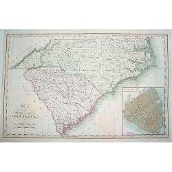
Map of the States of North & South Carolina..
An increasingly scarce map of North and South Carolina. This was one the first maps to provide accurate border divisions for the Carolina counties. Moreover, it was one o...
Date: London, 1831
Selling price: ????
Please login to see price!
Sold
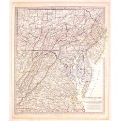
North America (Sheet VII) Pennsylvania, New Jersey, Maryland, Columbia and part of Virginia.
Very detailed sectional map of North America published by Baldwin & Cradock under the superintendence of the Society for the Diffusion of Useful Knowledge in London i...
Date: London, 1833
Selling price: ????
Please login to see price!
Sold in 2017
North America (Sheet XI) North and South Carolina.
Very detailed sectional map of North America published by Baldwin & Cradock under the superintendence of the Society for the Diffusion of Useful Knowledge in London i...
Date: London, 1833
Selling price: ????
Please login to see price!
Sold in 2017
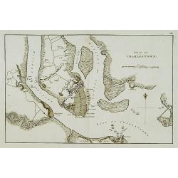
Siége de Charlestown.
Map showing vicinity around Charlestown. Showing a detailed plan of the town, roads, rivers or creeks & positions of the English troops.A french version of a map from...
Date: Paris, c. 1834
Selling price: ????
Please login to see price!
Sold
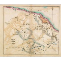
Plan of the investment and attack on York in Virginia.
Map showing vicinity around York, VA. Shows American artillery, French Hospital, roads, rivers or creeks & positions of troops. Also, note Field where the British lai...
Date: Philadelphia, 1806 -1834
Selling price: ????
Please login to see price!
Sold in 2014

"View of Baltimore"
A small but beautiful early 19th century view of Baltimore as seen from its Inner Harbour. Many important city sites are clearly visible. A very fine steel plate engravin...
Date: London, 1835
Selling price: ????
Please login to see price!
Sold

Capitulation de Cornwallis. Washington, Rochambeau, Lafayette - 19 Septembre 1781.
The plate, engraved by Delignon, shows a full-lentg figure of Washington in uniform, in company with Lafayette, Rochambeau and his officers, in the act of receiving the s...
Date: Paris, c.1840
Selling price: ????
Please login to see price!
Sold in 2009
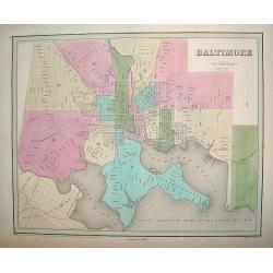
Baltimore.
Decorative town plan of Baltimore. The map highlight's the city's 14 boroughs and provides excellent street detail.Baltimore was a major commercial center during America'...
Date: Philadelphia and Boston, 1838 - corrected to 1846
Selling price: ????
Please login to see price!
Sold in 2011

Baltimore.
Beautiful lithography of Baltimore after a design by Louis Le Breton (1818 Douarnenez - 1866 Paris). He drew this charming view as one of a series showing major ports of ...
Date: Paris, Auguste Bry, ca. 1850
Selling price: ????
Please login to see price!
Sold in 2018
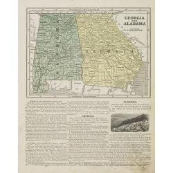
Georgia and Alabama.
Map of Georgia and Alabama. On verso a map of Louisiana, Mississippi and Arkansas. From Sidney E. Morse''s: System of Geography for the use of schools , published by Harp...
Date: New York, 1855
Selling price: ????
Please login to see price!
Sold in 2010
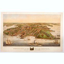
Bird's Eye View of the City of Annapolis, the Capitol of Maryland.
A wonderful large colored lithograph, by E. Sachse & Co., one of two important lithography companies operating in Baltimore during the mid nineteenth century, showing...
Date: Baltimore, ca 1855
Selling price: ????
Please login to see price!
Sold in 2020
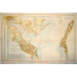
PATAPSCO RIVER AND THE APPROACHES
A large and wonderfuly detailed U. S. government chart of the Patapsco River and shoreline areas, including a finely engraved plan of Baltimore. The work contains a wealt...
Date: Washington D. C. , dated 1856
Selling price: ????
Please login to see price!
Sold
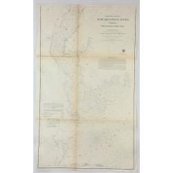
Preliminary Chart of Rappahannock River Virginia From Entrance to Deep Creek.
An informative large U.S. Coast Survey nautical chart of Virginia's Rappahannock River. It covers the course of the Rappahannock River from the Chesapeake Bay to Deep Cre...
Date: Washington, 1857
Selling price: ????
Please login to see price!
Sold in 2018
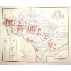
Plan von Washington 1845
A finely engraved plan of pre Civil War Washington D.C., as it was in 1845. There is an inset plan of the Capitol building, which was not yet built at the time. In additi...
Date: Heidelberg, 1860
Selling price: ????
Please login to see price!
Sold

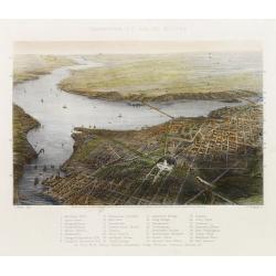
Balloon view of Washington, D. C.
An impressive wood cut balloon view of Washington, D. C. at the start of the American Civil War. The Capitol is seen in the foreground, with its dome under construction. ...
Date: New York, 1861
Selling price: ????
Please login to see price!
Sold
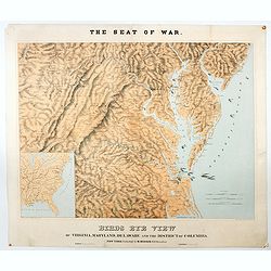
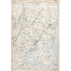
The Seat of War. Birds Eye View of Virginia, Maryland, Delaware and the District of Columbia.
A large and striking example of the seat of the civil war in the mid-Atlantic states in 1861. Extending from the southern reaches of New Jersey and Pennsylvania to northe...
Date: New York, London, Paris, 1861
Selling price: ????
Please login to see price!
Sold in 2020
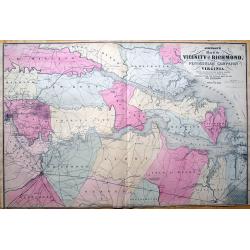
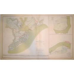
Johnson's Map of the Vicinity of Richmond, Peninsular Campaign in Virginia. Showing also the interesting localities along the James, Chickahominiy and York Rivers...
Important 1862 map of the vicinity of Richmond during the civil war. Shows the Union Advance during the Peninsular Campaign of the American Civil war.Highly detailed map,...
Date: New York, 1862
Selling price: ????
Please login to see price!
Sold in 2013
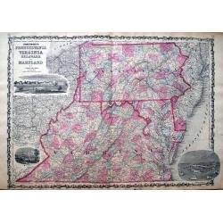
Johnson's Pennsylvania, Virginia, Delaware and Maryland.
Detailed map of Virginia, Maryland, Delaware and Pennsylvania, issued during the Civil War. The map pre-dates the formation of West Virginia and only appeared in the ear...
Date: New York, 1862
Selling price: ????
Please login to see price!
Sold in 2013
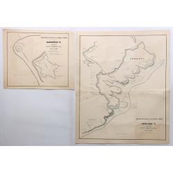
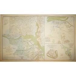
Reconnaissance of the Rebel Works at Gloucester Va. & Yorktown Va. (Two Maps)
Two fine maps of the “Reconnaissance of the Rebel Works” of Gloucester and Yorktown, Virginia. They were by Lieut. Comstock and Lieut. Abbot respectfully.They are qui...
Date: New York, 1862
Selling price: ????
Please login to see price!
Sold in 2018
Washington D.C. and its Vicinity.
Bird's eye-view. With a numbered key 1-33 for points of interest. Engraved by W. Ridgway after J. Wells.
Date: New York, ca. 1863
Selling price: ????
Please login to see price!
Sold
WASHINGTON CITY, D.C.
An impressive wood-cut panorama of Washington D.C, as seen during the middle of the American Civil War. The view centers on the White House, Patent Office and Post Office...
Date: New York, 1863
Selling price: ????
Please login to see price!
Sold
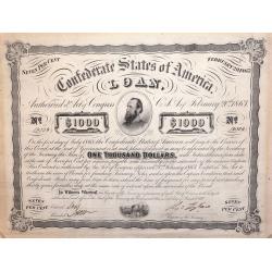
A Confederate States of America 1000 Dollar Loan Bond February 20th 1863.
American Civil War Bond of 1863, Low issue number, From the Confederate States of America 1000 Dollar Loan Bond: February 20th, 1863.With portrait of "Stonewall Jack...
Date: Richmond, VA. ca. 1863
Selling price: ????
Please login to see price!
Sold in 2014
Seat of war in Virginia and Maryland.
An important and very detailed map of the District of Columbia, Eastern Maryland and Virginia. Extends from Gettysburg to Fredericksburg and Leonardtown, and includes str...
Date: London, ca. 1863
Selling price: ????
Please login to see price!
Sold in 2018

Seat of War in Virginia. Sheet 3.
An important and very detailed map of a part of Virginia. With Richmond, Staunton, Charlottesville, Lynchburg, etc, that includes streets, railroads, towns, rivers, and m...
Date: London, ca. 1863
Selling price: ????
Please login to see price!
Sold in 2018
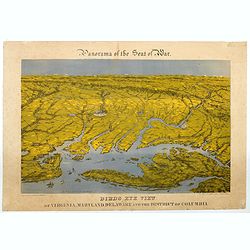
Panorama of the Seat of War. Bird's Eye View of Virginia, Maryland, Delaware and the District of Columbia.
A large chromolithograph by John Bachmann illustrating this fascinating 'aerial' view of the northernmost part of the east coast of the Confederacy, and the southernmost ...
Date: New York, 1864
Selling price: ????
Please login to see price!
Sold in 2020
Defenses of Washington
An impressive, beautifully detailed Civil War period plan of Washington D.C. showing the city's defenses. The plan is based on surveys completed in mid-1861 by the United...
Date: New York, 1865
Selling price: ????
Please login to see price!
Sold
"Map of the Defenses of Charleston City and Harbor Showing also the Works Erected by the U. S. Forces in 1863 and 1864"
A large and handsome chart of Charleston harbor and the city of Charleston originally drawn at the height of the American Civil War (1863-1864). The work shows Charleston...
Date: Washington D. C., ca. 1865
Selling price: ????
Please login to see price!
Sold
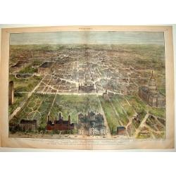
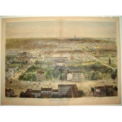
OUR NATIONAL CAPITAL VIEWED FROM THE SOUTH
A handsome, hard to find, double page bird's-eye panorama of Washington D.C. as seen in the early 1880's. This finely engraved wood-cut provides excellent detail of the c...
Date: New York, 1882
Selling price: ????
Please login to see price!
Sold
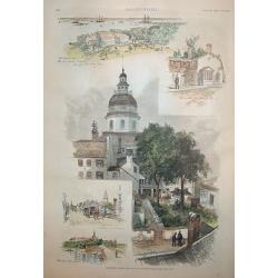
Annapolis, Maryland
A beautiful woodcut grouping incorporating five views of / in Annapolis, the capital of Maryland. The central view is of the old capitol building. The original U.S. Naval...
Date: New York, 1886
Selling price: ????
Please login to see price!
Sold
![Foundery on Jone's Creek near Baltimore. . [title in French, English, German & Latin] N°52. Pl. 4.](/uploads/cache/26804-250x250.jpg)
Foundery on Jone's Creek near Baltimore. . [title in French, English, German & Latin] N°52. Pl. 4.
A view of Jone's Creek foundery near Baltimore.From 13e Livraison Amérique Septentrionale - Etat de New York. After Jacques Milbert and lithographed by Bichebois and fig...
Date: Paris, Bove dirigée par Nöel ainé & Cie, 1892
Selling price: ????
Please login to see price!
Sold in 2009
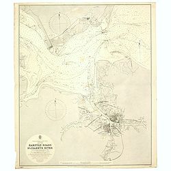
Hampton road and Elizabeth River. . .
A fine Hydrographic Office chart no. 2818, figuring Hampton Road, the James and Elizabeth Rivers and the cities of Norfolk and Portsmouth. Engraved by J. and C. Walker. L...
Date: London, 1892 / 1900
Selling price: ????
Please login to see price!
Sold in 2020
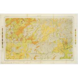
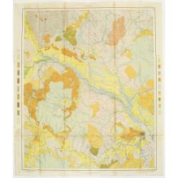
Soil map - North Carolina, Asheville sheet.
Soil map printed by Julius Bien & Co in New York for Department of Agriculture. The map is giving great detail of the area including and west of Asheville, North Caro...
Date: New York, 1903
Selling price: ????
Please login to see price!
Sold in 2017
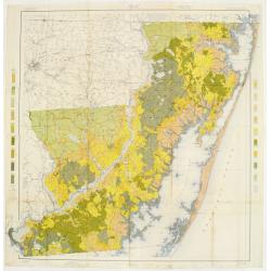
Soil map - North Carolina, Craven sheet
Early color lithographed soil map by Julius Bien & Co. in New York for Department of Agriculture. Legends at side give detail on soil type, etc. They also include int...
Date: New York, 1903
Selling price: ????
Please login to see price!
Sold
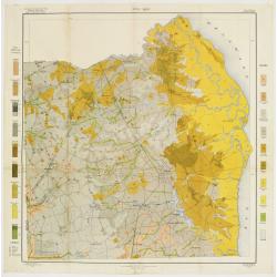
Soil map - Maryland, Worcester County sheet
Early color lithographed soil map by Julius Bien & Co. in New York for Department of Agriculture. Legends at side give detail on soil type, etc. They also include int...
Date: New York, 1903
Selling price: ????
Please login to see price!
Sold in 2009
Soil map - Delaware, Dover sheet.
Early color lithographed soil map by Julius Bien & Co. in New York for Department of Agriculture. Legends at side give detail on soil type, etc. They also include int...
Date: New York, 1903
Selling price: ????
Please login to see price!
Sold in 2018
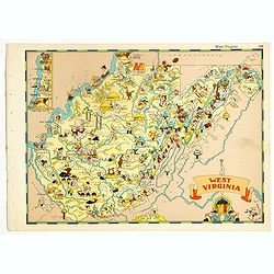
West Virginia.
Pictorial map of West Virginia, from the famous illustrator, Ruth Taylor White and published in "Our USA: A Gay Geography".Ruth Taylor White was among the most ...
Date: Boston, Little, Brown and Company, 1935
Selling price: ????
Please login to see price!
Sold in 2018
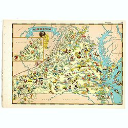
Virginia.
Pictorial map of Virginia, from the famous illustrator, Ruth Taylor White and published in "Our USA: A Gay Geography".Ruth Taylor White was among the most proli...
Date: Boston, Little, Brown and Company, 1935
Selling price: ????
Please login to see price!
Sold in 2018
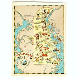
Delaware.
Pictorial map of Delaware, from the famous illustrator, Ruth Taylor White and published in "Our USA: A Gay Geography".Ruth Taylor White was among the most proli...
Date: Boston, Little, Brown and Company, 1935
Selling price: ????
Please login to see price!
Sold in 2018
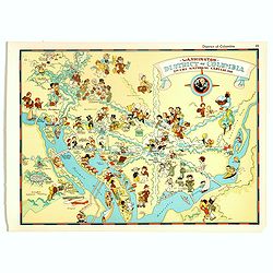
Washington, District of Columbia, the national capital.
Pictorial map of Washington, District of Columbia, the national capital, from the famous illustrator, Ruth Taylor White and published in "Our USA: A Gay Geography&qu...
Date: Boston, Little, Brown and Company, 1935
Selling price: ????
Please login to see price!
Sold in 2017
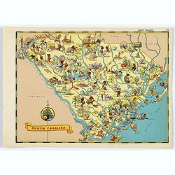
South Carolina.
A fun, humorous, whimsical map of South Carolina by Ruth Taylor White.
Date: Boston, ca 1935
Selling price: ????
Please login to see price!
Sold in 2020
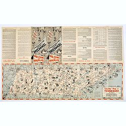
Chuckle Map of Tennessee.
A comic 'look' at the state of Tennessee, packed with highways, towns, points of interest, sports, produce, and lots of cartoon like characters depicting various activiti...
Date: Nashville, ca. 1940
Selling price: ????
Please login to see price!
Sold in 2018
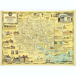
Historical Map of Old Baltimore.
A lovely, detailed map of the old 'downtown' area of Baltimore.
Date: Baltimore, 1954
Selling price: ????
Please login to see price!
Sold in 2017
