Browse Listings in America > North America > North America
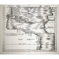
Tabula Terre Nove.
Waldseemuller's map of the New World shows the Atlantic coast of the Americas from latitudes 35 degrees south to 55 degrees north, including 20 place-names on the North A...
Date: Basle c.1513/1520
Selling price: ????
Please login to see price!
Sold
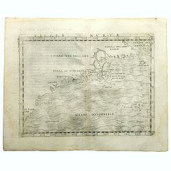
Terra Nueva
Gastaldi's map of Eastern USA from Giacomo Gastaldi's Atlas of 1548 which has been called the most comprehensive atlas, produced between Martin Waldseemüller's Geographi...
Date: Venice, 1548
Selling price: ????
Please login to see price!
Sold in 2023
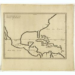
Descripcion De Las Yndias Del Norte.
Map of the Southern United States, Mexico, Central America, and the Caribbean, from his Description des Indes Occidentales Qu'on appelle aujourdhuy Le Nouveau Monde. . fi...
Date: Amsterdam, Michel Colin, 1622
Selling price: ????
Please login to see price!
Sold in 2017
![[Unmounted gores from a very rare Dutch Globe]](/uploads/cache/46309-250x250.jpg)
[Unmounted gores from a very rare Dutch Globe]
These rare gores are very possibly the only surviving examples from a 17 inch (44cm) diameter globe by Hondius and Janssonius. It is believed that only four of five examp...
Date: Amsterdam, ca 1623
Selling price: ????
Please login to see price!
Sold in 2020
![[Natives American Indians plagued by the devil ].](/uploads/cache/40178-250x250.jpg)
[Natives American Indians plagued by the devil ].
Scarce print (150x177mm.) on a German text sheet taken from a first edition of Johann Ludwig Gottfried's "Newe Welt Vnd Americanische Historien/ Jnhaltende Warhaffti...
Date: Frankfurt, M.Merian, 1633
Selling price: ????
Please login to see price!
Sold in 2018
![Insulae Americanae in Oceano Septentrionali, cum terris adjacentibus [Rare Blaeu West Indische Pascaert Wall Map Section]](/uploads/cache/36201-250x250.jpg)
Insulae Americanae in Oceano Septentrionali, cum terris adjacentibus [Rare Blaeu West Indische Pascaert Wall Map Section]
On 11 February 1634, Willem Blaeu announced the publication of a world atlas in four languages. He was able to complete only the German edition in that year. In order to ...
Date: Amsterdam, 1634
Selling price: ????
Please login to see price!
Sold in 2015
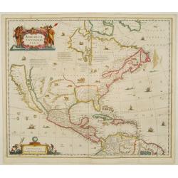
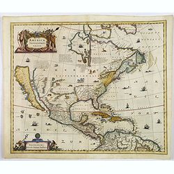
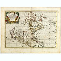
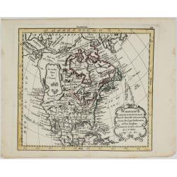
America septentrionalis.
A first state of this important map showing California as an island. Lacking any imprint in the cartouche, lower left. From the first French text edition. The north-west ...
Date: Amsterdam 1639
Selling price: ????
Please login to see price!
Sold
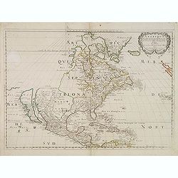
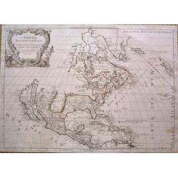
America Septentrionalis.
Showing California as an island, and above, the north west of the continent left blank except for two legends explaining the discoveries to that date. The Hudson Bay is c...
Date: Amsterdam 1640
Selling price: ????
Please login to see price!
Sold
Description de la Nouvelle France ou sont remarquees les diverse habitations des Francois, depuis la premiere descouvert jusques a present, recueillie et dressee sur diverses relations modernes
VERY RARE FIRST STATE, a second state was issued circa 1664. In superb condition. Important GREAT LAKES map first issued in 1643. According to Burden it is actually the f...
Date: Paris, 1643
Selling price: ????
Please login to see price!
Sold in 2012
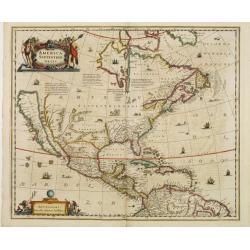
America Septentrionalis.
Showing California as an island, and above, the north west of the continent is left blank except for two legends explaining the discoveries to that date. The Hudson Bay i...
Date: Amsterdam 1647
Selling price: ????
Please login to see price!
Sold
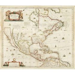
America Septentrionalis.
Showing California as an island, and above, the north west of the continent is left blank except for two legends explaining the discoveries to that date. The Hudson Bay i...
Date: Amsterdam 1647
Selling price: ????
Please login to see price!
Sold
America Septentrionalis.
A wonderful map showing California as an island, and above, the northwest of the continent is left blank except for two paragraphs explaining the discoveries to date. Int...
Date: Amsterdam, ca 1650
Selling price: ????
Please login to see price!
Sold in 2019
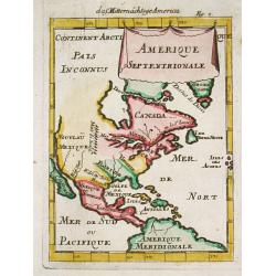
Amerique Septentrionale par N. Sanson.
Decorative and important map of the Americas with a CALIFORNIA AS AN ISLAND. Engraved by Abraham Peyrounim (c.1620 - c.1666).Sanson's map of North America is the first to...
Date: Paris, after 1650
Selling price: ????
Please login to see price!
Sold in 2014
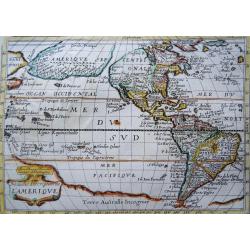
Nouvelle Description de l´Amerique
Extremely rare mid 17th century French map of North and South America (and Antarctica) by the French cartographer Tassin. Published in Paris by Berey in 1651 in ´Carte g...
Date: Paris, 1651
Selling price: ????
Please login to see price!
Sold in 2023
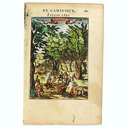
Native Americans Bring Food & Water & Treasure.
Fine Historical hand-colored copperplate engraving featuring Native Americans bringing food and treasure. Arnoldus Montanus (1625–1683) was a Dutch teacher and aut...
Date: Amsterdam. 1671
Selling price: ????
Please login to see price!
Sold in 2013
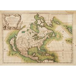
L' America Settentrionale. Nuouamente corretta, et accresciuta secondo le relationi piu moderne, da GVGLIELMO SANSONE. . .
Rossi's map of North America, based upon Sanson's seminal map, but with revised Italian nomenclature. Includes a detailed California as an Island on Sanson's model, and e...
Date: Rome, 1677
Selling price: ????
Please login to see price!
Sold in 2015
L'America Settentrionale.
Full title: 'L' America Settentrionale. Nuouamente corretta, et accresciuta secondo le relationi piu moderne, da GVGLIELMO SANSONE Geografe di S M Chrisftianis. E data in...
Date: Rome, 1677
Selling price: ????
Please login to see price!
Sold in 2015
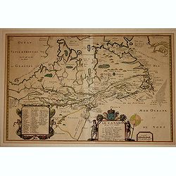
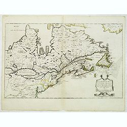
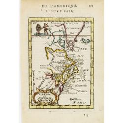
Le Canada faict par le St. de Champlain..
The fourth printed state of Champlain's 1616 plate of Canada. According to Wroth, Du Val somehow came into possession of the Champlain plate, printed a proof state, then ...
Date: Paris, 1677
Selling price: ????
Please login to see price!
Sold in 2012
American Family at Rest.
Interesting map of a Native American family at rest. It gives an indication of dress, foods and customs. Olfert Dapper (1635 – 1689) was a Dutch physician and write...
Date: Amsterdam, 1681
Selling price: ????
Please login to see price!
Sold in 2015
Amerique Septentrionale.
A charming late 17th century French map of North America, showing California to 40 degrees North and labelled I.Calfornie.
Date: Paris, 1683
Selling price: ????
Please login to see price!
Sold in 2008
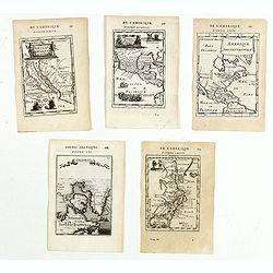
(Five maps of North American interest from Description de l'Univers)
Finely etched maps entitled : Nouveau Mexique et Californie, Mexique et nouvelle Espagne, Amerique Septentrionale, De l'Amerique, Groenlande".From the French text ed...
Date: Paris, 1683
Selling price: ????
Please login to see price!
Sold in 2015
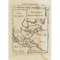
Canada ou Nouvelle France. (together with) United States.
A strange early depiction of the Eastern Seaboard, from Terres Arctiques Incognues to Virginie, including also an outline of the Great Lakes. Native Indians appear at the...
Date: Paris, 1683
Selling price: ????
Please login to see price!
Sold in 2012
Hurons.
Attractive copper engraving, depicting Huron Indians or Wynadot / Wendat people hunting and gathering .
Date: Paris, 1683
Selling price: ????
Please login to see price!
Sold in 2016
Canada ou Nouvelle France.
A charming late 17th century French map of east coast of Canada and North America.Greenland drawn close to the Canadian coast. The Great Lakes are shown open-ended in the...
Date: Paris, 1683
Selling price: ????
Please login to see price!
Sold
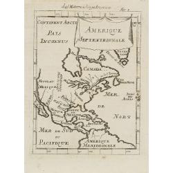
Amerique Septentrionale.
A charming map of North America showing only the island of California at about 40 degrees north. The Great Lakes are open-ended in the west and called Mer Douce and there...
Date: Paris, 1683
Selling price: ????
Please login to see price!
Sold in 2020
Amerique Septentrionale.
A charming late 17th-century French map of North America, showing California to 40 degrees North and labelled I.Calfornie.
Date: Paris 1683
Selling price: ????
Please login to see price!
Sold
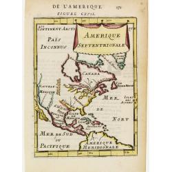
Amerique Septentrionale.
A charming late 17th-century French map of North America, showing California to 40 degrees North and labeled I.Calfornie.From the German text edition published by Davis Z...
Date: Frankfurt, 1684
Selling price: ????
Please login to see price!
Sold in 2008
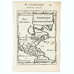
Amerique Septentrionale.
Alain Manneson Mallet (1603-1706) published in 1683 his ' Description de l' Univers' in 5 volumes. In 1686 a German edition appeared.Allain Mallet's attractive little map...
Date: Frankfurt, 1686
Selling price: ????
Please login to see price!
Sold in 2008
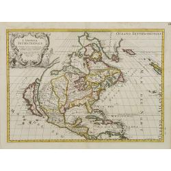
L'America Settentrionale..
Second edition of Rossi's map of North America, based upon Sanson's seminal map, but with revised Italian nomenclature. From Rossi's Mercurio Geographico..Includes a deta...
Date: Rome 1687
Selling price: ????
Please login to see price!
Sold
L'America Settentrionale. Nuovamente Corretta et Accresciuta Secondo le Relationi Piu Moderne da Guglielmo Sansone Geografo ...
Second edition of Rossi's map of North America, based upon Sanson's seminal map, but with revised Italian nomenclature. From Rossi's Mercurio Geographico..Includes a deta...
Date: Rome, 1687
Selling price: ????
Please login to see price!
Sold in 2012
Amerique septentrionale.
Engraved by Cordier. Spectacular example of Jaillot's map of North America, showing California as an Island, based upon Sanson's landmark map of 1656. This map shows the ...
Date: Paris, 1692
Selling price: ????
Please login to see price!
Sold
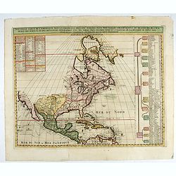
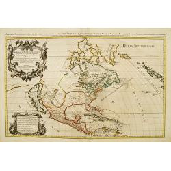
Nouvelle Carte de l' Amerique Septentrionale Dressee sur les plus Nouvelles Observations de Messieurs de l' Academie. . .
Great map of North America with well developed cartography in the Great Lakes and Mississippi River.It includes all of Central America and the West Indies. The English se...
Date: Amsterdam, 1720
Selling price: ????
Please login to see price!
Sold in 2022
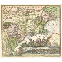
Recens Edita totius Belgii, in America
Arguably one of the most recognizable maps of the Northeastern American colonies this fifth state example of Novi Belgii by Tobias Conrad Lotter series does not disappoin...
Date: Augsburg, Germany 1757
Selling price: ????
Please login to see price!
Sold in 2023
![[Page from "Caroline Septentrionalr et Meridionale en 4 Feuilles . . ."]](/uploads/cache/26347-250x250.jpg)
[Page from "Caroline Septentrionalr et Meridionale en 4 Feuilles . . ."]
One sheet of four from the Le Rouge's version of this important large scale map of North Carolina. The upper right sheet showing the coastline of Corolina with Pamticoe S...
Date: Paris, 1777
Selling price: ????
Please login to see price!
Sold in 2008
Amerique Septentrionale avec les Nouvelles Découvertes
The map of the North America in a quiet unusual shape.Comes from rarely seen Jean-Baptiste Nolin atlas “Atlas Général a l’usage des colleges et maisons d’educatio...
Date: Paris, 1783
Selling price: ????
Please login to see price!
Sold in 2022
![[Official US Government Document.]](/uploads/cache/48156-250x250.jpg)
[Official US Government Document.]
An official US government printed document, completed in manuscript. An attractive copper engraved broadside, signed by President James Madison, appointing Daniel Chandle...
Date: Washington D.C., 1812
Selling price: ????
Please login to see price!
Sold in 2022
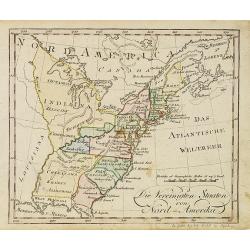
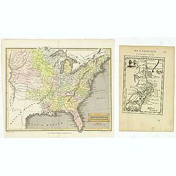
Die Vereinigten Staaten von Nord-Amerika.
Nice little German map of the early United States. The only state shown west of the Appalachian Mountains is Kentucky. Above which is a strangely shaped unnamed region (O...
Date: Augsburg, 1812
Selling price: ????
Please login to see price!
Sold
![[Official US Government Document.]](/uploads/cache/48153-250x250.jpg)
[Official US Government Document.]
Washington, D.C. February, 1815. partially-printed document, completed in manuscript, with a paper seal of the United States affixed to the lower left corner. An official...
Date: Washington D.C., 1815
Selling price: ????
Please login to see price!
Sold in 2022
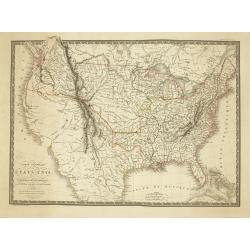
Carte Generale des Etats-Unis De L'Amerique Septentionale . . .
One of the earliest obtainable maps to show the United States From Coast to Coast, published in Paris by A.H. Brue.The map is especially interesting west of the Mississip...
Date: Paris, 1820
Selling price: ????
Please login to see price!
Sold in 2026
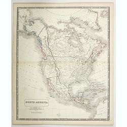
North America.
A detailed map of North America by William and Alexander Keith Johnston, a well-known publisher of maps who continually updated his maps. From his National Atlas of Geogr...
Date: Edinburgh, ca 1845
Selling price: ????
Please login to see price!
Sold in 2023
![[Official US Government Document.]](/uploads/cache/48158-250x250.jpg)
[Official US Government Document.]
An official US government printed document, completed in manuscript. An attractive engraved broadside, signed by President Andrew Johnson appointing John G. Chandler with...
Date: Washington D.C., 1867
Selling price: ????
Please login to see price!
Sold in 2022
![[Official US Government Document.]](/uploads/cache/48155-250x250.jpg)
[Official US Government Document.]
An official US government printed document, completed in manuscript and signed by President Theodore Roosevelt, appointing John G. Chandler Brigadier-General on the retir...
Date: Washington D.C., 1904
Selling price: ????
Please login to see price!
Sold in 2022
![[Official US Government Document.]](/uploads/cache/48154-250x250.jpg)
[Official US Government Document.]
An official US government printed document, completed in manuscript. An attractive engraved broadside, completed in manuscript and signed by President William Howard Taft...
Date: Washington D.C., 1910
Selling price: ????
Please login to see price!
Sold in 2022
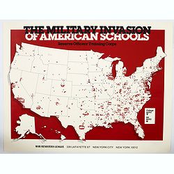
The Military Invasion of American Schools.
An interesting offset colour printed lithograph map / poster of the United States that is liberally covered in symbols of either black triangles or red circles, both high...
Date: New York, 1984
Selling price: ????
Please login to see price!
Sold in 2023
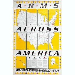
Arms Across America Waging Third World War.
This is a striking propaganda map, created by The War Registers League, founded 100 years ago in the U.S. it continues today as a secular, pacifist organization dedicated...
Date: New York, 1989
Selling price: ????
Please login to see price!
Sold in 2023
