Browse Listings in America > North America > Mississippi / Louisiana / Illinois / Missouri
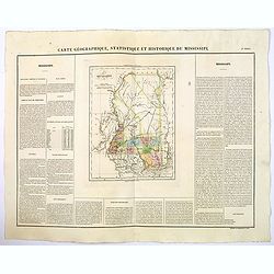
Carte Geographique, Statistique et Historique de Mississipi.
A nice detailed map of the state of Mississippi from Buchon's Atlas Gégraphique Statistique, historique et chronologique des deux Ameriques et des isles adjacentes tradui...
Date: Paris, 1825
Selling price: ????
Please login to see price!
Sold in 2020
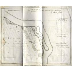
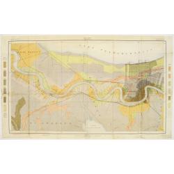
Land District North of Red River in the Sate of Louisiana.
An unusual map from an American land survey report, surveyed in 1823 by Maxfield Ludlow, and ordered by The House of Commons in 1827. It shows the Mississippi River with ...
Date: London, 1828
Selling price: ????
Please login to see price!
Sold in 2018
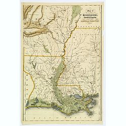
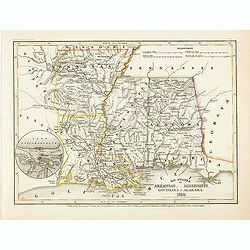
Map of the States of Mississippi, Louisians, and the Arkansas Territory.
An impressive steel engraved map of the southern American states of MS, LA, AR. by Isaac Hinton, published in "The History and Topography of the United States of Ame...
Date: London, 1832
Selling price: ????
Please login to see price!
Sold in 2018
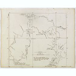
SOURCE OF THE MISSISSIPPI .
Finely executed pen drawing in brown ink. Scale is in English miles with many annotations.
Date: ca, 1836
Selling price: ????
Please login to see price!
Sold in 2015
Die staaten von Arkansas, Mississippi, Louisiana & Alabama 1850
Detailed steel engraved map with very nice detail of the major cities, roads and railways. Little Rock is also named "Arkopolis". From Meijers Zeitungs Atlas pu...
Date: Hildburghausen/ Philadelphia, 1846
Selling price: ????
Please login to see price!
Sold in 2014

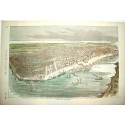
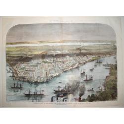
New Orleans
A beautifully rendered mid nineteenth century view of New Orleans, centered on the Mississippi River and the city's harbor. Many important sites are depicted as part of t...
Date: New York, ca. 1850
Selling price: ????
Please login to see price!
Sold in 2008
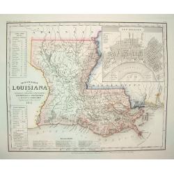
Neueste Karte von Lousiana.
This highly attractive work is from the German edition of the Tanner / Mitchell Louisiana map, forming part of the NEW UNIVERSAL ATLAS. It shows a German title with place...
Date: Hidleburgh, dated 1851
Selling price: ????
Please login to see price!
Sold in 2011

Birds' eye view of New Orleans. . .
A panoramic view of New-Orleans drawn from nature on stone by J.Bachman. Bird's-eye view of The Big Easy spread out along the banks of the Mississippi, upon which steambo...
Date: New York, 1851
Selling price: ????
Please login to see price!
Sold in 2015
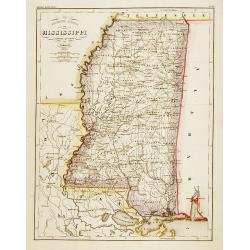
Neueste Karte von Mississippi..
Detailed map of the state Mississippi with numerous physical and political features including mines, settlements, trails/roads, forts and Indian areas. From "Meijers...
Date: Hildburghausen/ Philadelphia 1852
Selling price: ????
Please login to see price!
Sold

New Orleans from the Lower Cotton Press
A beautifully defined panoramic view of New Orleans as seen in the late 1840s / early 1850s. The harbor scene depicts numerous sailing ships, steamboats and other vessels...
Date: New York, 1852
Selling price: ????
Please login to see price!
Sold
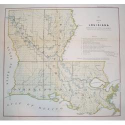
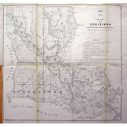
Map of Louisiana Representing the Several Land Districts
A handsome and very uncommon map of Louisiana. The work is a detailed survey of the State's various land divisions. A 12 point reference table provides letter coding and ...
Date: Donoldsonville, Louisiana, dated 1855
Selling price: ????
Please login to see price!
Sold
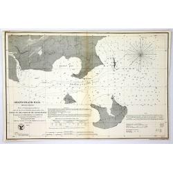
Grand Island Pass, Mississippi.
Antique Electrotype Map Published 1843-65, Washington for "Report of the Superintendent of the U.S. Coast Survey..." Published under the supervision and directi...
Date: Wahsington, 1857
Selling price: ????
Please login to see price!
Sold in 2016
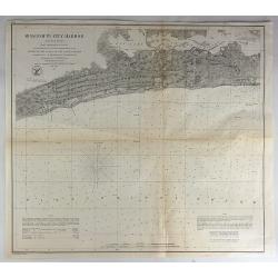
Mississippi Harbor.
Original lithograph of the U.S. Coast Survey map of Mississippi Harbor, Mississippi from 1857. It is from a trigonometrical survey under the direction of A.D. Bache Supe...
Date: Washington, 1857
Selling price: ????
Please login to see price!
Sold in 2018
Map of Louisiana Representing the Several Land Districts.
A very uncommon lithograph map of Louisiana. The work is a detailed survey of the State's various land divisions. A 12 point reference table provides letter coding and ic...
Date: Donoldsonville, 1859
Selling price: ????
Please login to see price!
Sold in 2013

Nouvelle Orléans.
A view of a part of the town of New Orleans, seen from the river with ships and boats in the foreground. After D. Fabronius (in the stone signed) and published by P. Crem...
Date: Bruxelles 1860
Selling price: ????
Please login to see price!
Sold
New Orleans
A desirable Civil War panoramic woodcut view of New Orleans. All major sites are depicted, including the Church of Saint Louis and French Quarter section. The city's harb...
Date: New York, dated 1862
Selling price: ????
Please login to see price!
Sold in 2008

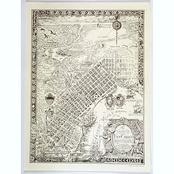
NEW ORLEANS
A handsome panorama of New Orleans as seen in the late 1830's. Perhaps the finest view of the city produced during the 19th century. Several key sites are depicted along ...
Date: New York, c. 1870
Selling price: ????
Please login to see price!
Sold

The Great Mississippi Steamboat Race.
A very decorative print of a steamboat race. Two riverboats, "Robert E. Lee" at left and "Natchez" at right, race from the right background toward the...
Date: New York, ca. 1870
Selling price: ????
Please login to see price!
Sold in 2014

New Orleans.
A famous mid 19th century view of the city of New Orleans from its southern dock section. The harbor perspective depicts a variety of river and ocean ships. Major landmar...
Date: New York, 1873
Selling price: ????
Please login to see price!
Sold

Moonlight on the Mississippi. Vapeur du Mississippi. Clair de lune sur le Mississippi.
"Moonlight on the Mississippi" showing the Great Republic. A closeup of the famous steamboat said to be surpassed only in size, speed and luxury by the J. M. Wh...
Date: New York, ca. 1875
Selling price: ????
Please login to see price!
Sold in 2014

City of New Orleans.
A very decorative bird's-eye view of New Orleans with the Mississippi River in the foreground. Lake Pontchartrain is visible in the distance. Keyed below image : Lake Pon...
Date: New York, ca. 1880
Selling price: ????
Please login to see price!
Sold in 2014
PANORAMIC VIEW OF NEW ORLEANS - THE FEDERAL FLEET AT ANCHOR IN THE RIVER, APRIL 25TH, 1862
A superb bird's-eye panoramic view of the city of New Orleans in April, 1862. From a special 1884 publication titled: "The Soldier in our Civil War an Illustrated H...
Date: New York, 1884
Selling price: ????
Please login to see price!
Sold
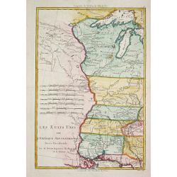
Les Etats Unis de l' Amerique Septentrionale, Partie Occidentale.
Rigobert Bonne (1727-1795), French cartographer. His maps are found in a.o. Atlas Moderne (1762), Raynal's Histoire Philos. du Commerce des Indes (1774) and Atlas Encyclo...
Date: Paris, 1787-1888
Selling price: ????
Please login to see price!
Sold
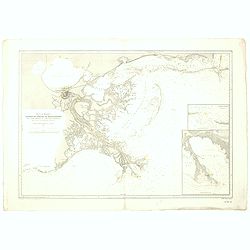
Sound et delta du Mississippi / de la baie de Mobile à la Nouvelle Orléans d'après les Cartes de l'United Coast Survey...
A fine French Service Hydrograhique de la Marine chart no.4710, showing the Mississippi Delta from Mobile Bay to New Orleans, after maps of the United Coast Survey. With ...
Date: Paris, 1894 / 1898
Selling price: ????
Please login to see price!
Sold in 2019
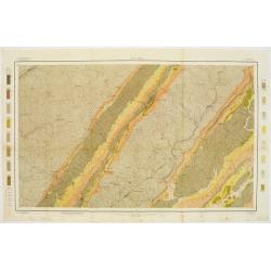
Soil map - Alabama, Fort Payne sheet.
Early color lithographed geological or soil map by Julius Bien & Co. in New York for the Department of Agriculture. Legends at the side give details on soil type, etc...
Date: New York, 1903
Selling price: ????
Please login to see price!
Sold in 2011
Louisiana, New Orleans sheet.
soil map printed by Julius Bien & Co in New York for Department of Agriculture. The map is giving great detail of the area in the east of New Orleans, Louisiana, in t...
Date: New York, 1903
Selling price: ????
Please login to see price!
Sold in 2013
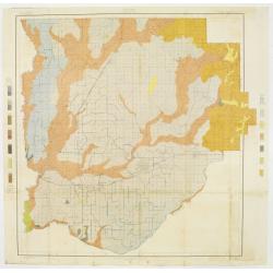
Soil map - Louisiana, Acadia Parish sheet.
Early color lithographed soil map by Julius Bien & Co. in New York for Department of Agriculture. Legends at side give detail on soil type, etc. They also include int...
Date: New York, 1903
Selling price: ????
Please login to see price!
Sold in 2009
The Creole City of New Orleans.
A large, decorative poster extolling the virtues of the all American city of New Orleans. It extends from Lake Pontchartrain and Spanish Fort, southwards, passing the Bay...
Date: New Orleans, 1930
Selling price: ????
Please login to see price!
Sold in 2018

North West Louisiana Fish and Game Preserve.
A different map of the North West Louisiana Fish & Game Preserve in 1931. Produced in New Orleans by the Department of Conservation commissioner, Robert S. Maestri. D...
Date: New Orleans, 1931
Selling price: ????
Please login to see price!
Sold in 2017
