Browse Listings in America
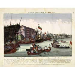
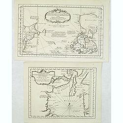
Neu Yorck - Na Nouvelle York.
A so-called optical print engraved by B.F. Leizelt, with underneath captions in German and French. Below the image, Augsburg, "au Negoce commun de l'Academie Imperia...
Date: Augsburg, ca. 1750
Selling price: ????
Please login to see price!
Sold in 2013
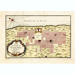
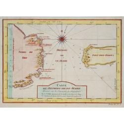
Plan de la Ville de Buenos Ayres.
The early layout of the town of Buenos Aires is shown in blocks, with a few of the important buildings named. Rococo title cartouche at lower left.Jacques Nicolaas Bellin...
Date: Paris, 1750
Selling price: ????
Please login to see price!
Sold in 2014
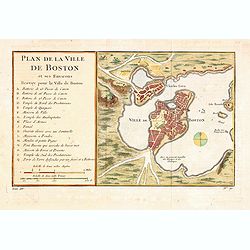
Plan de la Ville de Boston et ses Environs.
One of the earliest obtainable town plans of Boston and Charlestown, with an extensive index of 16 specific sites at left, each located on the map. Shows Boston 13 years ...
Date: Paris, 1750
Selling price: ????
Please login to see price!
Sold in 2014
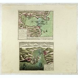
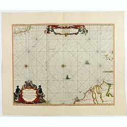
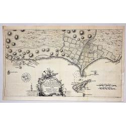
Portus Pulchri in Isthmo Panamensi / Scenographia Portus Pulchri
The birds-eye town-plan of Portobelo with title above, and a text panel "Dieser Grund Riss von dem Hafen, der Stadt u. den Forten von Porto belo ..." Below a sc...
Date: Nuremberg, c. 1750
Selling price: ????
Please login to see price!
Sold in 2015
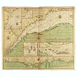
![Mappa Geographica Complectens I. Indiae Occidentalis Partem Mediam Circum Isthmum Panamensem. . . [With insets of St. Augstine, Florida, Mexico City, Panama, etc.]](/uploads/cache/37359-250x250.jpg)
Mappa Geographica Complectens I. Indiae Occidentalis Partem Mediam Circum Isthmum Panamensem. . . [With insets of St. Augstine, Florida, Mexico City, Panama, etc.]
Six varying sized insets depict the West Indies: Panama, Saint Augustine, Vera Cruz, Santo Domingo, and a birds-eye view of Mexico City. The primary, largest inset map ha...
Date: Nuremberg, 1750
Selling price: ????
Please login to see price!
Sold in 2016
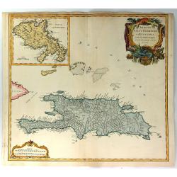
Isles de Saint Domingue ou Hispaniola, et de la Martinique.
This is a fine map of Hispaniola or Santo Domingo (modern day Haiti and the Dominican Republic) by Robert de Vaugondy. It includes the tip of Cuba and the Inagua Islands ...
Date: Paris, 1750
Selling price: ????
Please login to see price!
Sold in 2020
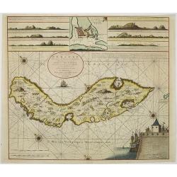
Het Westindisch Eiland Martenique
Taken from Isaac Tirion's atlas 'Nieuwe en Beknopte Hand-Atlas, bestaande in eene Verzameling van eenige der algemeenste en nodigste Landkaarten …' Decorative tropical ...
Date: Amsterdam, 1750
Selling price: ????
Please login to see price!
Sold in 2016
![Mappa Geographica Complectens I. Indiae Occidentalis Partem Mediam Circum Isthmum Panamensem. . . [With insets of St. Augstine, Florida, Mexico City, Panama, etc.]](/uploads/cache/42979-250x250.jpg)
Mappa Geographica Complectens I. Indiae Occidentalis Partem Mediam Circum Isthmum Panamensem. . . [With insets of St. Augstine, Florida, Mexico City, Panama, etc.]
Six varying sized insets depict the West Indies: Panama, Saint Augustine, Vera Cruz, Santo Domingo, and a birds-eye view of Mexico City. The primary, largest inset map ha...
Date: Nuremberg, 1750
Selling price: ????
Please login to see price!
Sold in 2019
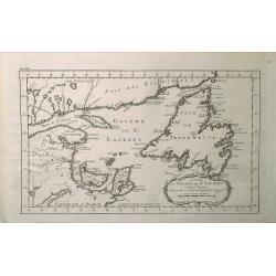
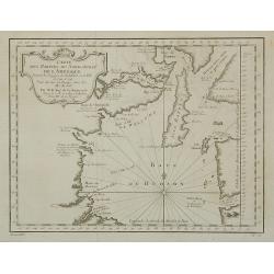
Carte du Golphe de St. Laurent et Pays Voisins.
A map from Prevost's 'Hist. des Voyages', depicting St. Lawrence Bay with Anticosti Island, Prince Edward island, Cape Breton Island, Newfoundland and the adjacent mainla...
Date: Paris, 1750
Selling price: ????
Please login to see price!
Sold in 2020
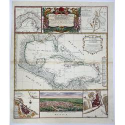
Mappa Geographica complectens. I. INDIAE OCCIDENTALIS partem mediam circum ISTHMUM PANAMENSEM. II. Ipsung Isthmuin. III. Ichnographiam praecipuorum locorum. . .
Six varying sized insets depict the West Indies: Panama, Saint Augustine, Vera Cruz, Santo Domingo, and a birds-eye view of Mexico City. The primary, largest inset map ha...
Date: Nuremberg, 1750
Selling price: ????
Please login to see price!
Sold in 2020
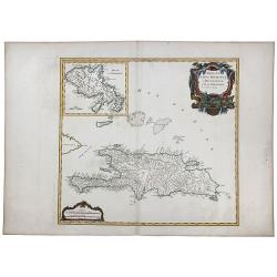
ISLES DE SAINT DOMINIGUE ou HISPANIOLA et de la Martinique.
This is a fine map of Hispaniola or Santo Domingo (modern day Haiti and the Dominican Republic) by Robert de Vaugondy. It includes the tip of Cuba and the Inagua Islands ...
Date: Paris, 1750
Selling price: ????
Please login to see price!
Sold in 2020
The Continent and Islands of America are divided and Possessed as follows. . .
A copper engraved map. Top half sheet of a 2-sheet map only. Printed in lower left corner is a key showing which regions and islands belong to the United States and Great...
Date: London, ca 1750
Selling price: ????
Please login to see price!
Sold in 2021

Painting of Tupinamba cannibals of Brazil set in a local landscape on wooden panel.
The iconography of this painting is derived from one of the plates illustrated in the third volume of "Grands Voyages" by Th. Bry taht was devoted to Brazil (Na...
Date: ca. 1750
Selling price: ????
Please login to see price!
Sold in 2023
![[Lot of 8 maps / views of Mexico] Ancien Mexico / Nouveau Mexico.](/uploads/cache/20705-250x250.jpg)
[Lot of 8 maps / views of Mexico] Ancien Mexico / Nouveau Mexico.
2 views of Mexico city, as in the times of the conquestedores and as in the 18th century.Plus 6 maps / views of Mexico. Together 8 items.
Date: c. 1750
Selling price: ????
Please login to see price!
Sold in 2022
![[9 maps of Peru and Chili]](/uploads/cache/20641-(1)-250x250.jpg)
[9 maps of Peru and Chili]
A map of the Southamerican continent from the Dutch edition of Robertson's ' History of America'.Plus 8 maps of Peru and Chili
Date: London, ca. 1750
Selling price: ????
Please login to see price!
Sold in 2022
![[lot of 5 maps/prints map of South America] Chili. Paraguay, Brésil, Amazones, et Pérou.](/uploads/cache/19976-(2)-250x250.jpg)
[lot of 5 maps/prints map of South America] Chili. Paraguay, Brésil, Amazones, et Pérou.
Louis Brion de la Tour (1756-1823), ' Atlas Géneral, Civil et Ecclésiastique', 1766, ' Atlas Général', 1790-98. Louis Charles Desnos (fl.1750-70), Paris-based publish...
Date: Paris, c. 1750
Selling price: ????
Please login to see price!
Sold in 2022
![[Lot of 22 maps / prints] Kaart van Mexico en Nieuw Granada in de Spaansche West-Indien.](/uploads/cache/20690-(3)-250x250.jpg)
[Lot of 22 maps / prints] Kaart van Mexico en Nieuw Granada in de Spaansche West-Indien.
A detailed map showing the Caribbeans, the Gulf of Mexico with its adjacent lands and Central America.. Izaak Tirion (d. 1769) Amsterdam publisher. His ' Nieuwe en beknop...
Date: Amsterdam, c. 1750
Selling price: ????
Please login to see price!
Sold in 2022
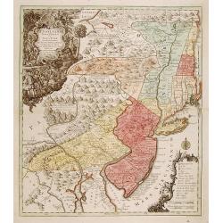
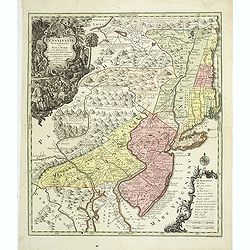
Pensylvania, Nova Jersey et Nova York..
One of the few maps to concentrate on this area and one of the most bizarre maps of North America ever published. The entire coastline is highly inaccurate; New Hampshire...
Date: Augsburg c.1751
Selling price: ????
Please login to see price!
Sold
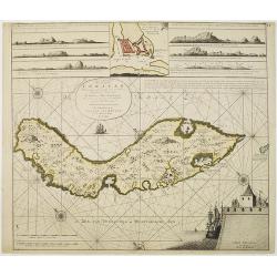
Nieuwe Afteekening van het Eyland Curacao vertoonende alle desselfs geleegentheden mitsgaders de haven van St. Anna en 't Fort Amsterdam int grood, als ook hoe sig dit Eyland uyt der zee vertoont
Decorative and extremely rare of Curaçao with several coastal insets and an inset of Fort Amsterdam and the Bay of St.Anna (127x135mm.)Besides the island of Curacao, th...
Date: Amsterdam, 1751
Selling price: ????
Please login to see price!
Sold in 2017
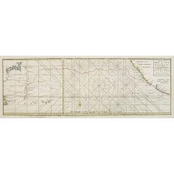
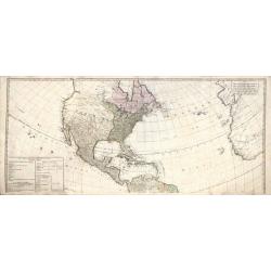
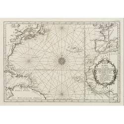
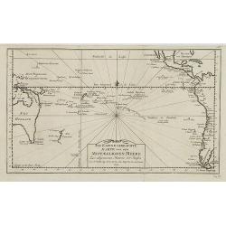
Carte de la Mer du Sud ou Mer Pacifique / Kaart van de ZUYD - ZEE of STILLE OCEAAN. . .
Map of the Pacific Ocean from the Northern Marianas Islands to the Californian and Mexican coastline. Important large-scale map of the Pacific Ocean. From \"Voyage A...
Date: Amsterdam, 1751
Selling price: ????
Please login to see price!
Sold in 2009
Nieuwe Afteekening van het Eijland Curaçao. . .
Decorative and extremely rare chart of Curaçao with several coastal insets and an inset of Fort Amsterdam and the Bay of St.Anna (127x135mm.)Besides the island of Curaca...
Date: Amsterdam, 1751
Selling price: ????
Please login to see price!
Sold in 2010
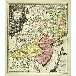
Pensylvania, Nova Jersey et Nova York..
Pre-Revolutionary War era map based on Lewis Evans’ map of 1749 and one of the few maps to concentrate on this area and one of the most bizarre maps of North America ev...
Date: Augsburg, c.1751
Selling price: ????
Please login to see price!
Sold in 2011
Pensylvania, Nova Jersey et Nova York..
Pre-Revolutionary War era map based on Lewis Evans’ map of 1749 and one of the few maps to concentrate on this area and one of the most bizarre maps of North America ev...
Date: Augsburg, c.1751
Selling price: ????
Please login to see price!
Sold in 2019
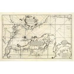
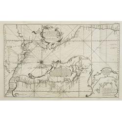
Nouvelle Carte de la Riviere de Canada ou St.Laurens de l'Isle de Anticoste jusqua Quebec. . .
A rare chart of the river St. Laurence with five insets. Including Montreal and Quebec.More about Van Keulen dynasty [+]
Date: Amsterdam, 1751
Selling price: ????
Please login to see price!
Sold in 2015
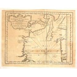
Pascaerte van Rio Gambia Als meede het Vaerwater tussen Cabo Verde en Brazil.
A highly decorative sea chart of the Atlantic Ocean between Gambia, Cap Verde and Brazil. On top is a figurative scale cartouche flanked with putti and in the lower left...
Date: Amsterdam, 1751
Selling price: ????
Please login to see price!
Sold in 2023
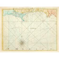
The Coast of West Florida and Louisiana..
Rare and important chart of Louisiana. Jeffery's was one of the most prolific and important English map publishers of the 18th century. His earliest known work was a plan...
Date: London 1752
Selling price: ????
Please login to see price!
Sold
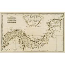
Carte particuliere de L'Isthme de Panama, Golfe de Darien, Côte de Carthagene..
This map provides an accurate picture of Panama.Jean Baptiste Bourguignon d'Anville (1697-1782) engraved his first map at age fifteen and produced many maps of high quali...
Date: Paris 1752
Selling price: ????
Please login to see price!
Sold
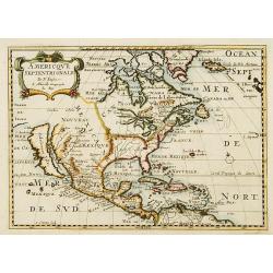
Amerique Septentrionale par N. Sanson.
Small decorative map of the Americas with a very large CALIFORNIA AS AN ISLAND.
Date: Amsterdam 1752
Selling price: ????
Please login to see price!
Sold
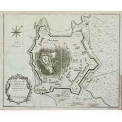
La Ville de Cayenne.
Plan of the city of Cayenne from Histoire générale des voyages … by Antoine François Prévost, published by Didot.
Date: Paris, 1752
Selling price: ????
Please login to see price!
Sold in 2011
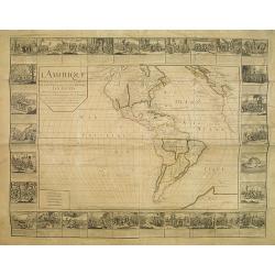
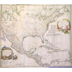
L'Amerique divisée en ses principalesparties. . .
RARE WALL MAP OF THE AMERICAS WITH DECORATIVE BORDERS. This wall map by Daudet is first described by Mcguirk, in his work about the "Mer de l'Ouest Mythe, see "...
Date: Lyon, 1752
Selling price: ????
Please login to see price!
Sold
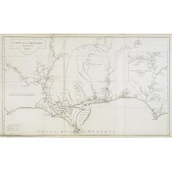
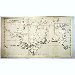
Carte de la Louisiane.
This map provides an accurate rendition of the lower Mississippi, the Arkansas, the Red, the Osage, and the lower Missouri rivers. Thomas Jefferson bought seven maps by A...
Date: Paris, 1752
Selling price: ????
Please login to see price!
Sold in 2009
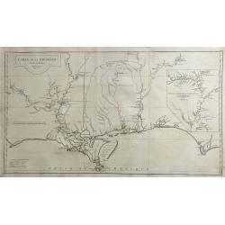
Carte de la Louisiane. . .
This map provides an accurate rendition of the lower Mississippi, the Arkansas, the Red, the Osage, and the lower Missouri rivers. Thomas Jefferson bought seven maps by A...
Date: Paris, 1752
Selling price: ????
Please login to see price!
Sold in 2016
Carte de la Louisiane.
This map provides an accurate rendition of the lower Mississippi, the Arkansas, the Red, the Osage, and the lower Missouri rivers. Thomas Jefferson bought seven maps by d...
Date: Paris, 1752
Selling price: ????
Please login to see price!
Sold in 2020
North America, Performed under the Patronage of Louis Duke of Orleans, First Prince of the Blood. By the Sieur d'Anville. . .
A lovely copper engraved map from 'The Universal Dictionary of Trade and Commerce (vols. 1 & 2)', by Malachy Postlethwayt / published by Paul Knapton, London, in 1755...
Date: London, 1752
Selling price: ????
Please login to see price!
Sold in 2020
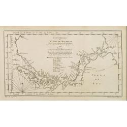
Carte Reduite, des Cotes De L'Acadie, de L'Isle Royale, et de la Partie Meridionale de L'Isle de Terre Neuve.
An important chart of Nova Scotia, southern Newfoundland and the Grand Banks, prepared after Chabert's voyage to Canada to update the French charts of Eastern Canada. It ...
Date: Paris, 1753
Carte reduite du Détroit de Magellan..
A good engraved map of Strait of Magellan. The geographical features are typical with somewhat exaggerated bays and inlets. From l'Histoire générale des voyages .
Date: Paris 1753
Selling price: ????
Please login to see price!
Sold
Karte von dem Abendlaendischen Ocean zur allgemeinen Historie der Reise beschreibungen entworfen von Hrn Bellin..
A nice and decorative map of the Atlantic Ocean.In: Allgemeine Historie der Reisen zur Wasser und zu Lande: oder Sammlung aller Reisebeschreibungen.. in Englischen zusamm...
Date: Leipzig, 1753
Selling price: ????
Please login to see price!
Sold
Neue und richtige Karte von dem Stillen Meere oder Mar der Sur . . . Pl.XXXVI.
Coastline map of Mexico starting from Acapulco and also including the Bay de San Francisco, the image oriented with East at the top of the image, which is largely of the ...
Date: Leipzig, 1753
Selling price: ????
Please login to see price!
Sold in 2015
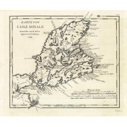
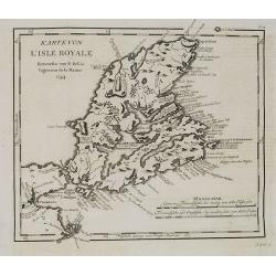
Karte von L'Isle Royale. . . . N°15.
Early map of Cape Breton Island - here called l'Isle Royale. An important island for the French as many strong holds were situated on the island. The most important was L...
Date: Leipzig, 1753
Selling price: ????
Please login to see price!
Sold in 2011
Carte Des Parties Du Nord-Ouest De L'Amerique . . .
Very nicely engraved chart that covers most of Hudson's Bay. Locates Fort Prince of Wales and Fort York, the Ottawa Islands (here the Bakers Dozen), the track of Henry El...
Date: Paris, 1753
Selling price: ????
Please login to see price!
Sold in 2011

Karte von dem Abenlaendischen Ocean sur allgemeinen Historie der Reife beschreibungen entworfen von Hrn Bellin. . .
Map of the Atlantic Ocean with outlines of the North American continent and the European and African continents.In: Allgemeine Historie der Reisen zur Wasser und zu Lande...
Date: Leipzig, 1753
Selling price: ????
Please login to see price!
Sold in 2008
Neue und richtige Karte von dem Stillen Meere oder Mar der Sur . . . Pl.XXXVI.
Coastline map of Mexico starting from Acapulco and also including the Bay de San Francisco, the image oriented with East at the top of the image, which is largely of the ...
Date: Leipzig, 1753
Selling price: ????
Please login to see price!
Sold in 2008
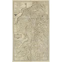
![Carte de la Meridiene mesurée au ROYAUME DE QUITO. . . [Karte von der Gemessenen Mittagslinie in dem Koenigreiche Quito. . .]](/uploads/cache/26172-250x250.jpg)
Carte de la Meridiene mesurée au ROYAUME DE QUITO. . . [Karte von der Gemessenen Mittagslinie in dem Koenigreiche Quito. . .]
A detailed map of Quito region, prepared in 1744. In: Allgemeine Historie der Reisen zur Wasser und zu Lande: oder Sammlung aller Reisebeschreibungen.. in Englischen zusa...
Date: Leipzig, 1753
Selling price: ????
Please login to see price!
Sold in 2009
In kleine gebrachte Karte von dem Mittaeglichen Meere . . .N°7.
Map of the Pacific and Oceania ocean from South America to Australia.In: Allgemeine Historie der Reisen zur Wasser und zu Lande: oder Sammlung aller Reisebeschreibungen.....
Date: Leipzig, 1753
Selling price: ????
Please login to see price!
Sold in 2008
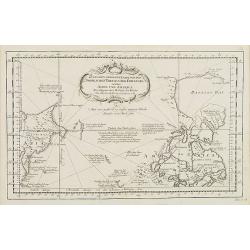
Zusammen Gezogene Karte von den Nordlichen Theilen der Erd-Kugel zwischen Asien und America. . . N°4.
Map of the Canadian Arctic regions with the eastern most Asian coastlines. In: Allgemeine Historie der Reisen zur Wasser und zu Lande: oder Sammlung aller Reisebeschreibu...
Date: Leipzig, 1753
Selling price: ????
Please login to see price!
Sold in 2009
KARTE von der Provinz Quito in Peru. . . N°8.
Detailed map of Peru. In: Allgemeine Historie der Reisen zur Wasser und zu Lande: oder Sammlung aller Reisebeschreibungen.. in Englischen zusammen getragen, und aus demse...
Date: Leipzig, 1753
Selling price: ????
Please login to see price!
Sold in 2009
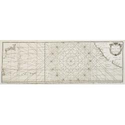
Carte de la Mer du Sud ou Mer Pacifique. . . Page 305.
Detailed map of the Pacific Ocean from the Northern Marianas Islands to the Californian coastline. In: Allgemeine Historie der Reisen zur Wasser und zu Lande: oder Sammlu...
Date: Leipzig, 1753
Selling price: ????
Please login to see price!
Sold in 2009
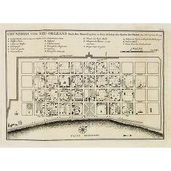
Grundriss von Neu-Orleans. . . N°18.
An important plan of New Orleans. In: Allgemeine Historie der Reisen zur Wasser und zu Lande: oder Sammlung aller Reisebeschreibungen.. in Englischen zusammen getragen, u...
Date: Leipzig, 1753
Selling price: ????
Please login to see price!
Sold in 2008
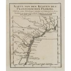
Karte von den Kpusten des Französischen Florida. . . N°3.
An important early city map of the South Carolina coast with Charlestown. In: Allgemeine Historie der Reisen zur Wasser und zu Lande: oder Sammlung aller Reisebeschreibun...
Date: Leipzig, 1753
Selling price: ????
Please login to see price!
Sold in 2008
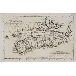
Karte von Accadia. . . N°2.
An important early map of Accadia and Isle Royale in Nova Scotia. Acadia (in the French language Acadie) was the name given to lands in a portion of the French colonial e...
Date: Leipzig, 1753
Selling price: ????
Please login to see price!
Sold in 2009
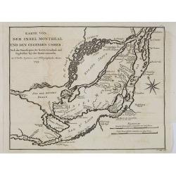
Karte von der insel Montreal und den degenden umher. . . N°5.
An important early map of the island and city of Montreal. In: Allgemeine Historie der Reisen zur Wasser und zu Lande: oder Sammlung aller Reisebeschreibungen.. in Englis...
Date: Leipzig, 1753
Selling price: ????
Please login to see price!
Sold in 2008
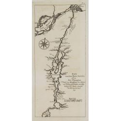
Karte von dem Flube Richelieu und dem See Champlain. . . N°IV.
An important early map of the Champlain River and its lake. In: Allgemeine Historie der Reisen zur Wasser und zu Lande: oder Sammlung aller Reisebeschreibungen.. in Engli...
Date: Leipzig, 1753
Selling price: ????
Please login to see price!
Sold in 2008
Karte von L'Isle Royale. . . . N°15.
Early map of Cape Breton Island - here called l'Isle Royale. An important island for the French as many strong holds were situated on the island. The most important was L...
Date: Leipzig, 1753
Selling price: ????
Please login to see price!
Sold in 2008
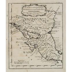
Karte von den Laendern Nicaragua und Coasta Rica. . . . N°18.
An important early map of Nicaragua and Costa Rica. In: Allgemeine Historie der Reisen zur Wasser und zu Lande: oder Sammlung aller Reisebeschreibungen.. in Englischen zu...
Date: Leipzig, 1753
Selling price: ????
Please login to see price!
Sold in 2008
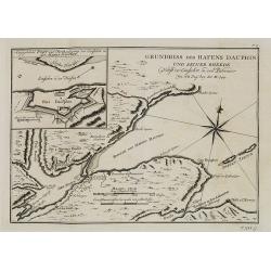
Grundriss des Hafens Dauphin. . . . N°17.
This map details St. Anns Bay on Cape Breton Island. Locates the walled Fort Dauphin (today's Englishtown) on the southern shore.Inset (9x11cm.) of "Angegebenes Fort...
Date: Leipzig, 1753
Selling price: ????
Please login to see price!
Sold in 2008
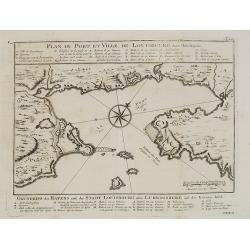
Plan du Port et ville de Louisbourg dans l'Isle Royale. N°XVI.
An important early map of the harbor of Louisbourg in the southeast portion of the island shown in great detail. Large compass rose and fleur-de-lis in the harbor. German...
Date: Leipzig, 1753
Selling price: ????
Please login to see price!
Sold in 2008
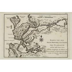
Karte von den Bayen, Rheeden und Hafen von Plaisance aus der Insel Terre Neuve. N°7.
An important early map of the Bay of Placentia on Newfoundland's southern coast with details of the region around the fort, of Placentia Bay (here Bay von Plaisance), the...
Date: Leipzig, 1753
Selling price: ????
Please login to see price!
Sold in 2008
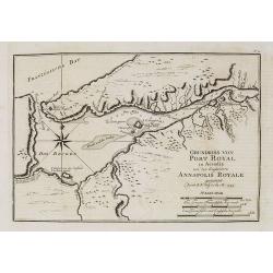
Grundriss von Port Royal in Accadia von den Englaendern Annapolis Royale. N° 12.
An important early map of Port Royal in Accadia. Acadia (in the French language Acadie) was the name given to lands in a portion of the French colonial empire in northeas...
Date: Leipzig, 1753
Selling price: ????
Please login to see price!
Sold in 2009
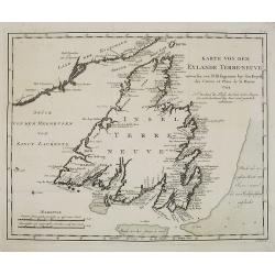
Karte von dem Eylande Terre-Neuve. N°6.
This important early map of the island of Terre-Neuve in Newfoundland shows a part of the mainland on the upper left and includes the Strasse von Bell' Isle and part of t...
Date: Leipzig, 1753
Selling price: ????
Please login to see price!
Sold in 2008
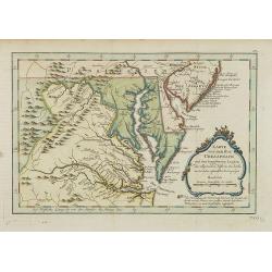
Karte von der Bay Chesapeack und den benachbarten Landen. . .
Uncommon German text edition of Bellin's important and interesting map of the Chesapeake Bay, with excellent detail on New Jersey, Maryland, Virginia, and Pennsylvania. I...
Date: Leipzig, 1753
Selling price: ????
Please login to see price!
Sold
Carte reduite du Détroit de Magellan . . .
A good engraved map of Strait of Magellan. The geographical features are typical with somewhat exaggerated bays and inlets. From l'Histoire générale des voyages.
Date: Paris, 1753
Selling price: ????
Please login to see price!
Sold in 2010
Carte du Détroit de Le Maire . . .
A good engraved map of Strait of Le Maire. From Histoire générale des voyages.
Date: Paris, 1753
Selling price: ????
Please login to see price!
Sold in 2011
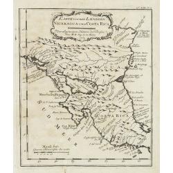
Karte von den Laendern Nicaragua und Coasta Rica. . . . N°18.
Early map of Nicaragua and Costa Rica. Published in: Allgemeine Historie der Reisen zur Wasser und zu Lande: oder Sammlung aller Reisebeschreibungen.. in Englischen zusam...
Date: Leipzig, 1753
Selling price: ????
Please login to see price!
Sold in 2011
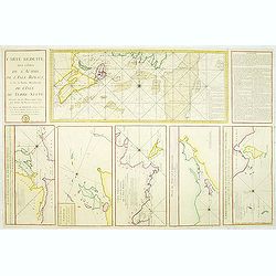
Carte Réduite des Côtes de l'Acadie et de la partie Méridionale de l'Isle de Terre-Neuve
Important chart of Nova Scotia, southern Newfoundland and the Grand Banks, prepared after Chabert's voyage to Canada to update the French charts of Eastern Canada. It sho...
Date: Paris, c. 1753
Selling price: ????
Please login to see price!
Sold in 2012
Carte Reduite du Detroit de Magellan. . .
Detailed chart of the Strait of Magellan from Cap des Vierges to Cap de la Victoire. The rococo title cartouche with title in French and Dutch "Gereduceerde Kaart va...
Date: Amsterdam, 1753
Selling price: ????
Please login to see price!
Sold in 2012
Two maps of North American interest.
Lot with two maps : "Zusammen gezogene Karte von den Nordlichen Theilen der Erd-Kugel zwischen Asien und America. . . " (210x340mm.) and "Karte von den Nor...
Date: Leipzig, 1753
Selling price: ????
Please login to see price!
Sold in 2013
Neue und richtige Karte von dem Stillen Meere oder Mar der Sur . . . Pl.XXXVI.
Coastline map of Mexico starting from Acapulco and also including the Bay de San Francisco, the image oriented with East at the top of the image, which is largely of the ...
Date: Leipzig, 1753
Selling price: ????
Please login to see price!
Sold in 2012
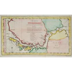
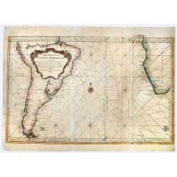
Carte réduite de l'Océan Méridional: contenant toutes les costes de l'Amérique Méridionale depuis l'Euqater jusqu' au 57 degré de latitude et les costes. . .
Map of Atlantic ocean. Showing the south-east coast of America, the south-west coasts of Africa. In the lower right the sign of the "Depôt de la Marine".Intere...
Date: Paris, 1753
Selling price: ????
Please login to see price!
Sold in 2016
Carte Réduite, Des Côtes De L' Acadie, De L' Isle Royale...
Important sea chart of Nova Scotia, southern Newfoundland and the Grand Banks, prepared after Chabert's voyage to Canada to update the French charts of Eastern Canada. A ...
Date: Paris, ca. 1753
Selling price: ????
Please login to see price!
Sold in 2014
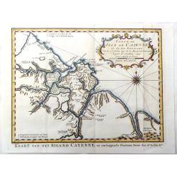
Carte de Isle de Caienne et ses Environs.
Attractive map of the coast of French Guyana on the western coast of South America. Decorated by a fine title cartouche and compass rose.From Raynal's "Histoire Phil...
Date: Paris, 1753
Selling price: ????
Please login to see price!
Sold in 2016
carte des Parties du Nord-Puest de L'Amerique
A fine map featuring northern Hudson Bay in northern Ontario in Canada. Large and decorative title cartouche. The map is from Prevost's "HISTORY OF VOYAGES" de...
Date: Paris, 1753
Selling price: ????
Please login to see price!
Sold in 2017
Suite de la carte réduite du Golphe de St Laurent contenant les costes de Labrador . . . le détroit de Belle-Isle et partie des cotes de l'Isle de Terre neuv
Sea , prepared and published by Nicolas Bellin. Relief shown by hachures. Depths shown by soundings.
Date: Paris, 1753
Selling price: ????
Please login to see price!
Sold in 2016
AMERICAE SEPTENTRIONALIS ad emendatiora Exemplaria adhuc edita jussu Aca. Reg. Scjent et. Pars I to IV.
Complete set of Euler's four-part map of North America, published in response to the maps of Mitchell and D'Anville. Part I covers the region from the Mississippi River ...
Date: Berlin, 1753
Selling price: ????
Please login to see price!
Sold in 2017
The Port of Callao in the South Sea with the Adjacent Islands, Rocks & Coasts.
A map by Thomas Jefferys, from The Gentleman's Magazine, published in London in 1753. This interesting map covers the present-day Lima Metropolitan Area, from the fishing...
Date: London, 1753
Selling price: ????
Please login to see price!
Sold in 2018
Carte Reduite de L' OCEAN MERIDIONAL Contenant Toutes les Costes de l' Amerique Meridionale. . .
A striking, large sea chart of the Southern Atlantic Ocean, showing most of the coast of South America and the Southwest coast of Africa, published by Nicolas Bellin. The...
Date: Paris, 1753
Selling price: ????
Please login to see price!
Sold in 2019

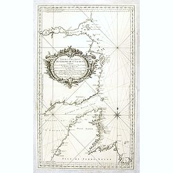
Carte du Golphe du Mexique et des Isles de l'Amerique.
Attractive map of the islands of the Caribbean that includes those parts of the United States & Mexico that border the Gulf of Mexico, Central America, and the northe...
Date: Paris, 1754
![[Eight scenes depicting various stages in the history of America]](/uploads/cache/25007-250x250.jpg)
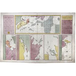
[Eight scenes depicting various stages in the history of America]
The side border of Longchamps wall map of America, here still in its uncut form. The eight scenes depicting various stages in the history of the continent. - Monarchie de...
Date: Paris, 1754
Selling price: ????
Please login to see price!
Sold in 2008
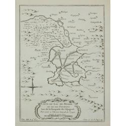
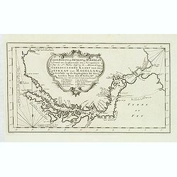
Carte du Lac de Mexico ...
A good engraved map of the capital of old Mexico, with rococo title cartouche lower part.From l'Histoire générale des voyages. Prepared by Jacques Nicholas Bellin (1703...
Date: Paris, 1754
Selling price: ????
Please login to see price!
Sold in 2011
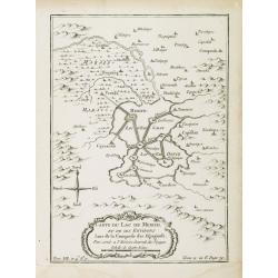
Carte du Lac de Mexico, et de ses environs Lors de la conqueste des Espagnols. . .
A good engraved map of the capital of old Mexico, with rococo title cartouche lower part. From l'Histoire générale des voyages.Mexico City showing its position on the L...
Date: Paris, 1754
Selling price: ????
Please login to see price!
Sold in 2014
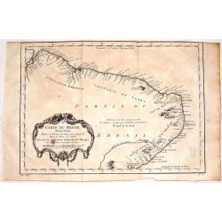
Carte du Bresil, Prem. Partie.
Fine copper engraving of the shoreline of Brasil from the Amazon River to the Bay of All Saints. Decorated by a large floral cartouche. Jacques Nicolas Bellin (1703–17...
Date: Paris, 1754
Selling price: ????
Please login to see price!
Sold in 2017