Browse Listings in America
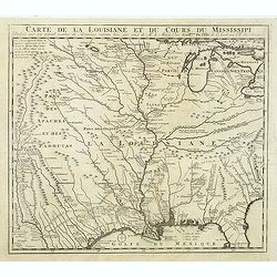
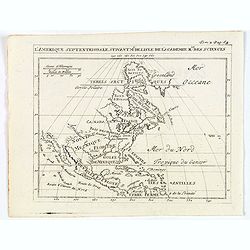
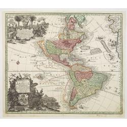
Carte de la Louisiane et du Cours du Mississipi Dressée sur un grand nombre de Memoires.
Anonymous map copied from the important de L'Isle map. The map shows "Natichitoches, éstablissemt. François fait en 1717 par Mr. De Bienville" and routes of e...
Date: Paris, c. 1720
Selling price: ????
Please login to see price!
Sold in 2012
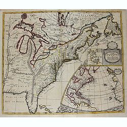
A new map of the English Empire in America. . .
This fine English map of eastern North America including Canada engraved by John Harris and first published by Robert Morden. John Senex acquired and made minor alteratio...
Date: London, 1720
Selling price: ????
Please login to see price!
Sold in 2013
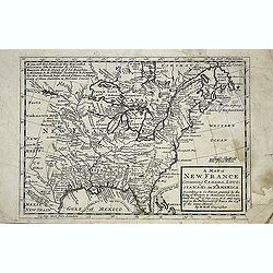
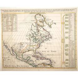
A new map of New France containing Canada, Louisiana &c. in N.th America. . .
A fine map of Canada, Great Lakes and most of South east New Foundland. For this edition the London meridian is used with Deg.West from London and Deg.East from London en...
Date: London, c. 1720
Selling price: ????
Please login to see price!
Sold in 2013
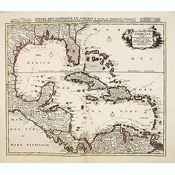
Insulae Americanae Nempe: Cuba, Hispaniola, Iamaica, Pto Rico, Lucania, Antillae vulgo Caribe, Barlo-et Sotto-Vento Etc. . . .
A rare re-issue of the plate by Danckerts. The West Indies with the gulf of Mexico and Florida. The map shows prominently in the center Cuba, Haiti, the Bahamas and Flori...
Date: Amsterdam, 1720
Selling price: ????
Please login to see price!
Sold in 2013
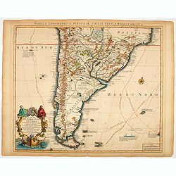
Carte du Paraguay, du Chili, du Detroit de Magellan &c.
A finely engraved, detailed map of the southern half of South America. Prepared by de l'Isle.
Date: Amsterdam, 1720
Selling price: ????
Please login to see price!
Sold in 2014
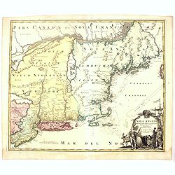
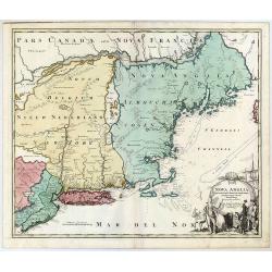
Nova Anglia Septentrionali Americae implantata ..
German interest in North America was high during the first half of the eighteenth century when Johan Baptiste Homann was the leading German cartographer. During this peri...
Date: Nuremberg, 1720
Selling price: ????
Please login to see price!
Sold in 2016
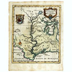
Louisiana by de Rivier Mississippi.
Scarce map of the Mississippi River Valley and Great Lakes regions. The map is primarily based on Hennepin with enlarged Great Lakes and the Mississippi located too far w...
Date: Amsterdam, ca. 1720
Selling price: ????
Please login to see price!
Sold in 2016
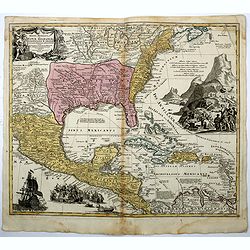
Regni Mexicani seu Novae Hispaniae, Floridae, Novae ..
The map shows the eastern sea board of America, the West Indies and the various estates and countries that border the Gulf of Mexico, with decorative, uncolored cartouche...
Date: Nuremberg, 1720
Selling price: ????
Please login to see price!
Sold in 2016
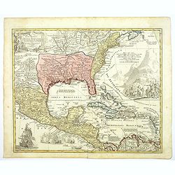
Regni Mexicani seu Novae Hispaniae, Floridae, Novae ..
The map shows the eastern sea board of America, the West Indies and the various estates and countries that border the Gulf of Mexico, with decorative -uncolored- cartouch...
Date: Nuremberg, 1720
Selling price: ????
Please login to see price!
Sold in 2016
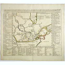
Carte particuliere du fleuve Saint Louis dressee sur les lieux avec les noms des sauvages du pais . . .
Map of the Great Lakes region, including the Northern reaches of the Mississippi, Hudson's Bay, and the Gulf of the St-Lawrence. Chatelain’s map is derived from Baron L...
Date: Amsterdam, 1720
Selling price: ????
Please login to see price!
Sold in 2019
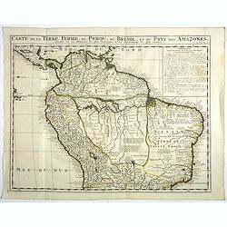
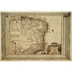
Carte de la Terre Ferme, du Perou, du Bresil, et du Pays des Amazones. . .
Handsome map of the northern part of South America based on the cartography of Guillaume Delisle.It is filled with place names and notations speculating about the Indian ...
Date: Amsterdam, 1720
Selling price: ????
Please login to see price!
Sold in 2017
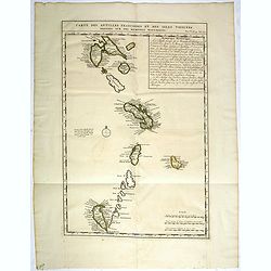
Carte des Antilles Françoises et des Isles voisines dressée sur des Mémoires Manuscrits.
Map of the West Indies Islands, with descriptive French text, from Chatelain's monumental 7 volume "Atlas Historique".Henri Abraham Chatelain (1684 – 1743) wa...
Date: Amsterdam, 1720
Selling price: ????
Please login to see price!
Sold in 2017
Lousiana by de Rivier Missisisppi.
A scarce little map of the Mississippi River Valley and western Great Lakes from the book “Het Groote Tafereel der Dwaasheid…” which accounts for the history of Joh...
Date: Amsterdam, 1720
Selling price: ????
Please login to see price!
Sold in 2019
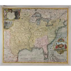
Amplissimae Regionis Mississipi Seu Provinciae Ludovicianae. . .
An iconic copperplate Map of the Mississippi Valley (United States, Louisiana, Texas, British Colonies) by Johann Baptiste Homann in Nuremberg in 1720. This map is often ...
Date: Nuremberg, 1720
Selling price: ????
Please login to see price!
Sold in 2017
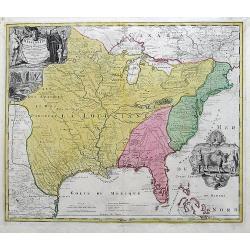
Amplissimae Regionis Mississipi... (The Bufflao Map).
Homann's important and highly decorative map of the Mississippi River Valley and the Southeast USA. Extends from the Great Lakes until the Bahamas, including Louisiana an...
Date: Nuremberg, c. 1720
Selling price: ????
Please login to see price!
Sold in 2017
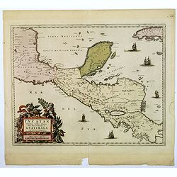
Yucatan conventus. . .Guatimala conventus. . .
A very handsome looking map, first published in 1662 by Blaeu, this later edition bears the imprint of Pierre Mortier. The map encompasses the area from Mexico City in th...
Date: Amsterdam, ca 1720
Selling price: ????
Please login to see price!
Sold in 2018
Afbeeldinge van't zeer vermaarde Eiland Geks-Kop. . .
The central map of the island of Madhead is contained in an elaborately engraved cartouche surrounded by scenes of ill-fated investors storming the offices of John Law's ...
Date: Amsterdam, 1720
Selling price: ????
Please login to see price!
Sold in 2019
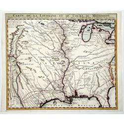
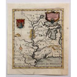
CARTE DE LA LOUISIANE ET DU COURS DU MISSISSIPI.
A nice example of Jean Frederic Bernard's rare variant edition of Guillaume De L'Isle's seminal map, one of the most important and influential maps of the 18th Century, w...
Date: Amsterdam, 1720
Selling price: ????
Please login to see price!
Sold in 2019
Nova Anglia Septentrionali Americae Implantata Anglorumque Coloniis Florentissima Geographice Exhibita.
A decorative map of the New York and New England region.
Date: Nuremberg, ca 1720
Selling price: ????
Please login to see price!
Sold in 2020
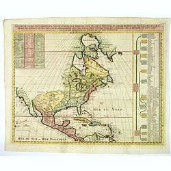
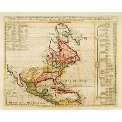
Nouvelle Carte de l' Amerique Septentrionale Dressee sur les plus Nouvelles Observations de Messieurs de l' Academie. . .
A superb map of North America with well developed cartography in the Great Lakes and Mississippi River.It takes in all of Central America and the West Indies. The English...
Date: Amsterdam, 1720
Selling price: ????
Please login to see price!
Sold in 2020
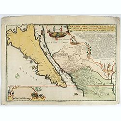
La Californie ou Nouvelle Caroline.
This fine rare map is a reissue of de Fer's map of 1705 but on a larger scale, and with some notable additions. A boldly engraved and handsome item, the largest scale map...
Date: Paris, 1720
Selling price: ????
Please login to see price!
Sold in 2022
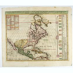
Nouvelle Carte de l' Amerique Septentrionale Dressee sur les plus Nouvelles Observations de Messieurs de l' Academie. . .
Great map of North America with well developed cartography in the Great Lakes and Mississippi River.It includes all of Central America and the West Indies. The English se...
Date: Amsterdam, 1720
Selling price: ????
Please login to see price!
Sold in 2022
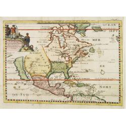
Amerique Septentrionale Par N.Sanson d\'Abbeville Geograph du Roy.
A general map of North America showing California as an island but with few names.From the book \"Nouvelle Relation, Contenant LES VOYAGES DE THOMAS GAGE dans la nou...
Date: Amsterdam, 1721
Selling price: ????
Please login to see price!
Sold
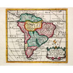
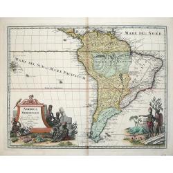
Amerique Meridionale.
A nice small map of South America.
Date: Amsterdam, 1721
Selling price: ????
Please login to see price!
Sold in 2008
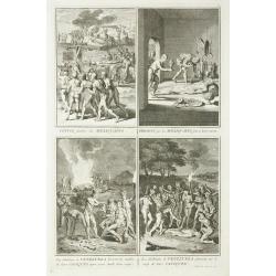
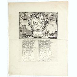
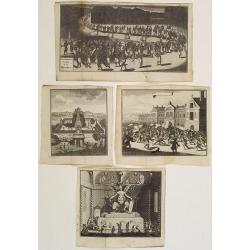
Convoi funebre des Mexiquains. / Presens que les Mexiquains font a leurs morts. / Les Habitans de Venezuela boivent les cendres ... / Les Habitans de Venezuela pleurent ...
Four prints in one sheet depicting funeral customs in Mexico.
Date: Amsterdam, 1721
Selling price: ????
Please login to see price!
Sold in 2011
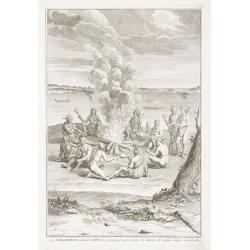
Les Virginiens, adorent le Feu, ...
Print depicting a gathering around a fire in Virginia.
Date: Amsterdam, 1721
Selling price: ????
Please login to see price!
Sold in 2011
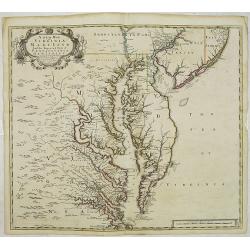
A New Map of Virginia Mary=Land And The Improved Parts of Penn=sylvania & New Jersey Most humbly Inscribed to the Right Hon.ble the Earl of Orkney . . . 1719..
Christopher Browne's map was first published, as a separate issue, in 1685. John Senex obtained the plate and, changed only the imprint, republished it in his atlas of 17...
Date: London, 1721
Selling price: ????
Please login to see price!
Sold in 2012
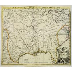
A map of Louisiana and of the Mississipi.
A scarce first English version of the influential map published by Guillaume De L'Isle in 1718.The original was a landmark map in the cartography of the region, centered ...
Date: London, 1721
Selling price: ????
Please login to see price!
Sold
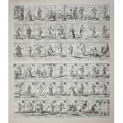
Pasquins Windkaart op de Windnegotie van 't Iaar 1720.
Undivided engraved sheet of 54 pictorial playing cards. Engraving on mounted paper.This is an early 18th-century uncut playing card sheet based on the disastrous collapse...
Date: Amsterdam, 1721
Selling price: ????
Please login to see price!
Sold in 2013
![Carte du Gouvernement de l' Amerique [California Island].](/uploads/cache/82994-250x250.jpg)
Carte du Gouvernement de l' Amerique [California Island].
An interesting chart depicting the European possessions in North and South America. A wonderful example of Chatelain’s elegant maps. Included in the 1721 edition of the...
Date: Amsterdam, 1721
Selling price: ????
Please login to see price!
Sold in 2019
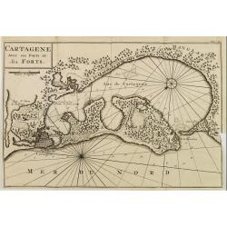
CARTAGENE Avec ses Ports et ses FORTS.
Decorative map of Cartagena, fortified colonial harbour in Colombia.
Date: Amsterdam 1722
Selling price: ????
Please login to see price!
Sold
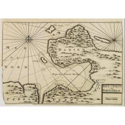
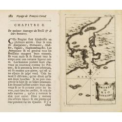
BAYE et FORTS de PORTO BELO.
Decorative map of the Portobelo Bay, in the region of Darien, Panama.From Voyages de François Coreal aux Indes Occidentales, Contenant ce qu'il y a vû de plus remarquab...
Date: Amsterdam 1722
Selling price: ????
Please login to see price!
Sold
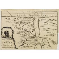
Baye et Ville de La HAVANA ou de S. CHRISTOVAL.
Attractive map centred on the town Havana and its large bay.
Date: Amsterdam 1722
Selling price: ????
Please login to see price!
Sold
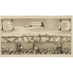
S. SALVADOR.
Charming view of Salvador de Bahia, in Brazil, seen from the ocean. With ribbon style title cartouche and 2 cartouches containing a key list. Decorated with 4 European ve...
Date: Amsterdam 1722
Selling price: ????
Please login to see price!
Sold
Entrée de Rio Janeiro.
Fine view of the entrance of Baía de Guanabara, in Rio de Janeiro.From Voyages de François Coreal aux Indes Occidentales, Contenant ce qu'il y a vû de plus remarquable...
Date: Amsterdam 1722
Selling price: ????
Please login to see price!
Sold
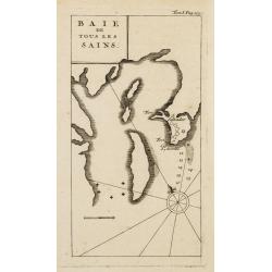
BAIE de Tous Les SAINS.
Fine view of Baía de Todos os Santos, in Bahia. With the town of Salvador outlined at the entrance of the bay.From Voyages de François Coreal aux Indes Occidentales, Co...
Date: Amsterdam 1722
Selling price: ????
Please login to see price!
Sold
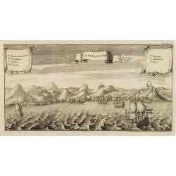
S. SEBASTIEN.
Charming view of São Sebastião de Rio de Janeiro, taken from the ocean. With ribbon style title cartouche and 2 cartouches containing a lettered key list (A-G). Decorat...
Date: Amsterdam 1722
Selling price: ????
Please login to see price!
Sold
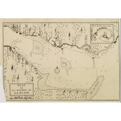
PLAN de la Riviere de la PLATE.
Appealing map focusing on the River de la Plata. With inset plan of "Baye des Maldonades", in Uruguay.From Voyages de François Coreal aux Indes Occidentales, C...
Date: Amsterdam 1722
Selling price: ????
Please login to see price!
Sold
(Lot of 4 prints relating to Mexico.)
Lot of 4 prints illustrating the traditional rites and events concerning the native people of Mexico.From the book "Nouvelle Relation, Contenant LES VOYAGES DE THOMA...
Date: Amsterdam, 1722
Selling price: ????
Please login to see price!
Sold in 2020
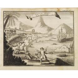
Surprise des INDIENS de la Guardeloupe..
Interesting print depicting the arrival of Europeans in Guadeloupe.From the book Nouvelle Relation, Contenant LES VOYAGES DE THOMAS GAGE dans la nouvelle Espagne [..] jus...
Date: Amsterdam 1722
Selling price: ????
Please login to see price!
Sold
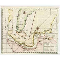
Carte du Dêtroit de Magellan.
Detailed map of Strait Magellan. With a key lower right stating the different smaller islands in the strait.Relief shown pictorially. Decorated with 2 large compass roses...
Date: Amsterdam 1722
Selling price: ????
Please login to see price!
Sold
![La Ville de Mexique. [together with ] Environs du. . .](/uploads/cache/22545-250x250.jpg)
La Ville de Mexique. [together with ] Environs du. . .
Lot of two views of Mexico City. From "Voyages de François Coreal aux Indes Occidentales, Contenant ce qu'il y a vû de plus remarquable pendant son séjour depuis ...
Date: Amsterdam, 1722
Selling price: ????
Please login to see price!
Sold in 2008
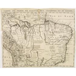
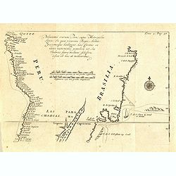
Carte du Perou, du Fleuve des Amazones et du Bresil.
Appealing map focusing on the Amazon Basin, therefore including large part of the Brazilian Peruvian and Bolivian territories. Relief shown pictorially.From "Voyages...
Date: Amsterdam, 1722
Selling price: ????
Please login to see price!
Sold in 2010
Carte d'Amerique.
This is a typically fine map by Guillaume de l'Isle, here with the address Sur le Quay d'Horloge, dated 1722.Early second state. The west coast of North America is deline...
Date: Paris, 1722
Selling price: ????
Please login to see price!
Sold in 2012
Carte du Mexique et de la Floride des Terres Angloises et des Isles Antilles. . .
Covens & Mortier's issue of Delisle's important map showing the south-eastern part of the United States, Mexico and the Caribbean Sea. It is credited with accurately ...
Date: Amsterdam, c. 1722
Selling price: ????
Please login to see price!
Sold in 2016
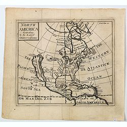
North America According to the Latest Observations.
State 1 with north latitude 60 deg. above the Arctic Circle. First issued in: Geography Anatomiz'd... The ninth edition. . . and a set of new maps by Mr. Senex / Patrick ...
Date: London, ca 1722
Selling price: ????
Please login to see price!
Sold in 2023
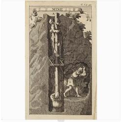
Mine.
Interesting print illustrating the entrance of a mine and part of a tunnel. It was mend to describe the hard labour to which the native Peruvian were forced.From "Vo...
Date: Amsterdam, 1722
Selling price: ????
Please login to see price!
Sold in 2020
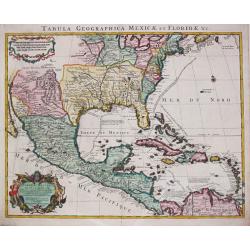
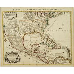
Tabula Geographica Mexicae et Floride des Terres Angloises et des Isles Antilles, du Cours et des Environs de la Riviere de Mississipi. Par G. de l' Isle a Amsterdam chéz Jean Covens & Corneille Mortier. 1722.
Guillaume de l' Isle (1675-1724), Royal Geographer, was the most influential cartographer of the first quarter of the 18th century. ' Atlas de Géographie' (1700-12), pos...
Date: Amsterdam, 1722
Selling price: ????
Please login to see price!
Sold in 2022
Descripcion de las Yndias Ocidentales
Rare Spanish map of the Pacific and Americas. As usual Spain tried to limit the exploit of their geographical knowledge through piracy and therefore only allowed limited ...
Date: Madrid, c.1723
Selling price: ????
Please login to see price!
Sold
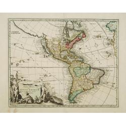
L'Amérique Septentrionale suivant Mr. Delisle de l'Académie Royale des Sciences.
A copper engraving map of the North American continent from the atlas Science des personnes de la cour, a rare and richly illustrated handbook for aristocrats at the roya...
Date: Amsterdam, 1723
Selling price: ????
Please login to see price!
Sold in 2018
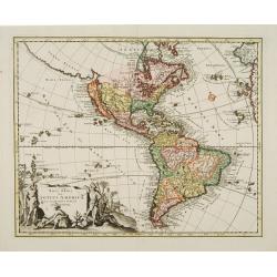
L'Amerique Septentrionale suivant M. de Lisle de l'Academie Royaume des Sciences.
An attractive copper engraving map from the Science des personnes de la cour de l'Epee et de la Robe, a rare and richly illustrated handbook for aristocrats at the French...
Date: Amsterdam, 1723
Selling price: ????
Please login to see price!
Sold in 2020
AMERICA MERIDIONALIS.
Very attractive map of the continent of South America with typical 18th century cartography, much of it fanciful. The large pictorial title cartouche features the peoples...
Date: Nuremberg, 1724
Selling price: ????
Please login to see price!
Sold in 2012
Novi Orbis Sive Totius Americae Cum Adiacentibus Insulis..
A double-page copper-engraved map, with original full coloring. The state with in the extreme north Pacific the key Gold-Catholisch Erdfarb Heydnisch [Gold = Catholic/ Ea...
Date: Nuremberg 1725
Selling price: ????
Please login to see price!
Sold
Novi Orbis Sive Totius Americae Cum Adiacentibus Insulis..
A double-page copper-engraved map, with original full coloring. California is a 1500-mile-long island, with the Strait of Anian Fretum Aniani due north and Anian an eastw...
Date: Nuremberg 1725
Selling price: ????
Please login to see price!
Sold
Novus Orbis sive America Meridionalis et Septentrionalis..
A finely engraved and decorative mid-18th century map published in Augsburg, Germany and incorporating two large decorative title cartouches upper right and bottom left. ...
Date: Augsburg 1725
Selling price: ????
Please login to see price!
Sold
Pelineatis anarium Peru cujus Metropolis Lima : In qua vicarus Regis, Archie piscopusque . . . . ( Tome 2 Page 48)
Uncommon map of the central part of South America with Peru, Brasil. Only coastal names.From the French reissue of the account of early Dutch voyages first published in 1...
Date: Amsterdam, F. Bernard, 1725
Selling price: ????
Please login to see price!
Sold in 2017
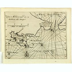
Côté méridional de la Terre Del Fuego.
Uncommon map of the southern most tip of Tiera del Fuego. From the French reissue of the account of early Dutch voyages first published in 1608 by Commelin. The French tr...
Date: Amsterdam, F. Bernard, 1725
Selling price: ????
Please login to see price!
Sold in 2017
Typus freti Magellanici quod . . .
Striking dark impression of De Renneville's edition of the Van Spilbergen map of the Straits of Magellan. The map includes a remarkable topographical treatment of the Str...
Date: Amsterdam, F. Bernard, 1725
Selling price: ????
Please login to see price!
Sold in 2017
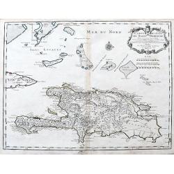
Carte de l'Isle de Saint Domingue Dressee en 1722. . .
An excellent map of Hispaniola with many details: Towns are connected with roads, many small rocks and islands shown, including Tortuga. Extends to show a tip of Cuba, an...
Date: Paris, 1725
Selling price: ????
Please login to see price!
Sold in 2020
...this map of South America...
Map of South America including part of Central America. Cartographic elements include lines of latitude and longitude, compass rose, indication of wind directions, locati...
Date: London 1725
Selling price: ????
Please login to see price!
Sold in 2021
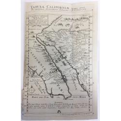
Tabula Californiae Anno 1702 ex Autoptica Observatione Delineata a R.P. Chino e S.I.
Map of California based on Kino's map, originally drawn in 1702. Kino's map carefully records the results of nine journeys he made in northwestern Mexico and along the Co...
Date: Augsburg, 1726
Selling price: ????
Please login to see price!
Sold in 2019
![Tabula Californiae, Anno 1702 … Ex autoptica observatione delineata a R.P. Chino e S.I. [The Map of California in 1702 as Observed and Drawn by Father Chino, S. J.]](/uploads/cache/85891-250x250.jpg)
Tabula Californiae, Anno 1702 … Ex autoptica observatione delineata a R.P. Chino e S.I. [The Map of California in 1702 as Observed and Drawn by Father Chino, S. J.]
The much sought after so-called KINO-map of California as a peninsula, a result of Father Kino's travels which misspelled the island-phantasy. This his second map is...
Date: Augsburg & Graetz, 1726
Selling price: ????
Please login to see price!
Sold in 2021
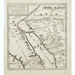
Passage par Terre a la Californie ..
Father Kino's important map was the first map to accurately depict the region, in particular the relative positions of the Colorado and Gila rivers and the correct locali...
Date: Paris, 1727
Selling price: ????
Please login to see price!
Sold in 2011
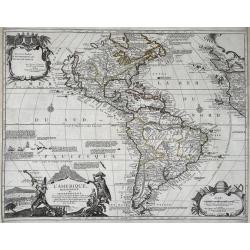
L'Amerique, Meridionale, et Septentrionale.
An uncommon map of the Americas. Full title in a decorative cartouche at bottom left: 'L'Amerique, Meridionale, et Septentrionale Dressee selon les Dernieres Relations et...
Date: Paris, 1727
Selling price: ????
Please login to see price!
Sold in 2021
Le Bresil, suivant les nouvelles observations. . .
Striking copper engraved map surrounded in a large picture-frame style border and title cartouche depicting mining. Great coastal detail with numerous notations concernin...
Date: Leyden, 1728
Selling price: ????
Please login to see price!
Sold in 2023
Nouvelle Carte L'Amérique Septentrionale..
Map of Northern America, including northern Venezuela and Baffin Bay. All five of the Great Lakes are present: but Lake Erie is unnamed. The Ohio River is shown, but unna...
Date: Amsterdam 1728
Selling price: ????
Please login to see price!
Sold
Nouvelle Carte L'Amérique Septentrionale..
Map of Northern America.
Date: Amsterdam 1728
Selling price: ????
Please login to see price!
Sold
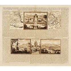
..Ville de Mexique des deux Lacs..Grand Temple..
This copper-engraving shows a map of Mexico, a map with the Lake of Mexico and area, also showing three panoramic views, one of the city Mexico, one of the large Temple o...
Date: Amsterdam, 1728
Selling price: ????
Please login to see price!
Sold in 2014
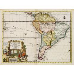
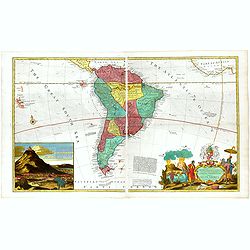
L'Amerique Meridionale. Suivant les nouvelles observations?
Detailed map of South America. Decorative cartouche lower left.Although not renowned for the originality of his work, Pieter van der Aa is highly thought of for the desig...
Date: Amsterdam 1728
Selling price: ????
Please login to see price!
Sold
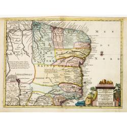
Le Bresil. Suivant les nouvelles observations?
Detailed map of Brazil. Decorative cartouche lower right.Although not renowned for the originality of his work, Pieter van der Aa is highly thought of for the design and ...
Date: Amsterdam 1728
Selling price: ????
Please login to see price!
Sold
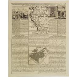
Carte Particuliere du Perou, Plan de la Ville de Lima, Description de Quelques Plantes, Animaux, &..
An interesting folio sheet containing two maps and two engravings with panels of French text. The top map covers the Northwest coast of South America from Panama to north...
Date: Amsterdam 1728
Selling price: ????
Please login to see price!
Sold
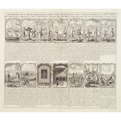
Description de la peche, habillemens..
This sheet contains fourteen vignettes of the Virginia colony after De Bry's engravings of John White's drawings. 130 years later he chose these illustrations because the...
Date: Amsterdam 1728
Selling price: ????
Please login to see price!
Sold
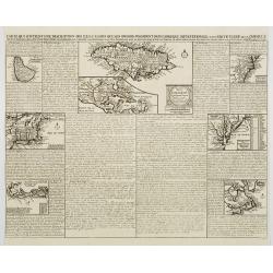
Carte qui contient..Iles & Terres..L'Amerique..Jamaique..
Eight maps on one sheet. From Chatelain's Atlas Historique et Méthodique. Including maps of Bermuda, Jamaica, New England with Long Island, Carolina, Chesapeake and Dela...
Date: Amsterdam, 1728
Selling price: ????
Please login to see price!
Sold
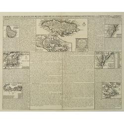
Carte qui contient une description des iles & terres que les anglois possedent dans L'Amerique Septentrionale . . . Jamaique. . .
Eight maps on one sheet showing the English colonies in North America including Barbados, Jamaica, New England, Bermuda, part of Canada showing the St. Lawrence River and...
Date: Amsterdam, 1728
Selling price: ????
Please login to see price!
Sold in 2016
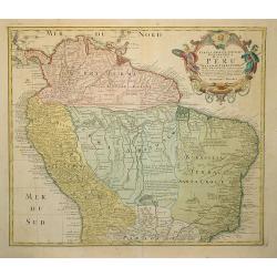
Tabula Americae Specialis Geographica Regni Peru . . .
A good and clean copy of Homann's map of the northern part of South America. Imposing title cartouche.
Date: Nuremberg 1728
Selling price: ????
Please login to see price!
Sold in 2011
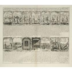
Description de la peche, habillemens ?
This sheet contains fourteen vignettes of the Virginia colony after De Bry's engravings of John White's drawings. 130 years later he chose these illustrations because the...
Date: Amsterdam, 1728
Selling price: ????
Please login to see price!
Sold in 2009
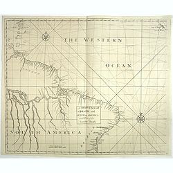
A chart of the coast of Brazil and Guiana in America with part of the Caribbe Islands.
This fine English chart of Brazil, Suriname and a few Caribbean Islands has two large compass roses in the Atlantic Ocean. From "Atlas Maritimus & Commercialis, ...
Date: London, 1728
Selling price: ????
Please login to see price!
Sold in 2017
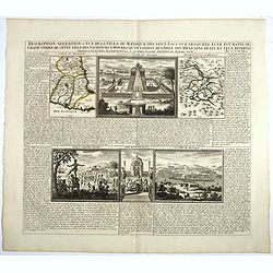
Description, situation et vue de la ville de Mexique des deux Lacs..Grand Temple..
This copper-engraving shows a map of Mexico, a map with the Lake of Mexico and area, also showing three panoramic views, one of the city Mexico, one of the large Temple o...
Date: Amsterdam, 1728
Selling price: ????
Please login to see price!
Sold in 2017
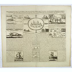
Description des castors & de leur industrie . . .
Fascinating engraving depicting how people from Canada use castors in many ways.Henri Abraham Chatelain (1684 – 1743) was a Huguenot pastor of Parisian origins. He live...
Date: Amsterdam, 1728
Selling price: ????
Please login to see price!
Sold in 2017
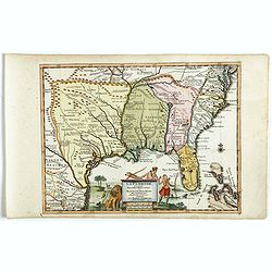
La Floride suivant les nouvelles observations...
Uncommon edition of this map of Florida. From Le Nouveau Theatre du Monde, ou la Geographie Royale.
Date: Amsterdam, 1728
Selling price: ????
Please login to see price!
Sold in 2020