Browse Listings in Africa > Southern Africa
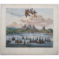
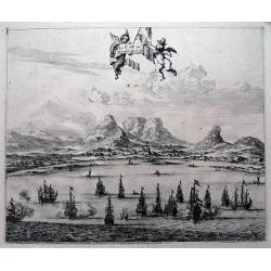
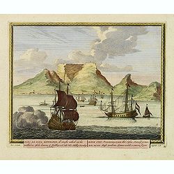
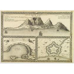
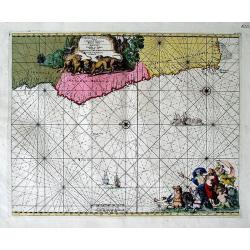
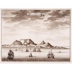
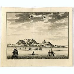
LE CAP DE BONNE ESPERANCE.
Probably the finest view of Cape Town. Beautifully engraved. A sea battle in the foreground with at least 15 galleons.With Tabletop mountain as the backdrop. Two putti ho...
Date: Leiden, ca 1700
Selling price: ????
Please login to see price!
Sold in 2021
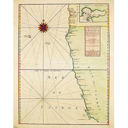
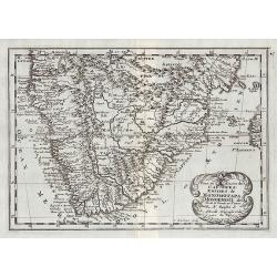
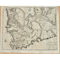
Carte Particuliere des Costes de l ' Afrique depuis Cabo Ledi jusques au Cap de Bone Esperance.
Carte Particuliere des Costes de l ' Afrique depuis Cabo Ledi jusques au Cap de Bone Esperance. Pieter Mortier (1661-1711), Amsterdam bookseller and printer of French des...
Date: Amsterdam, 1700
Selling price: ????
Please login to see price!
Sold in 2020
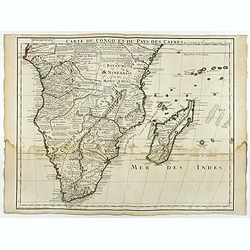
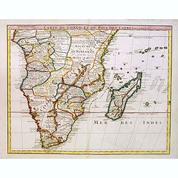
![[Lot of 9 maps / prints of SOUTH AFRICA] Carte du Congo et du Pays des Cafres.](/uploads/cache/19581-(1)-250x250.jpg)
[Lot of 9 maps / prints of SOUTH AFRICA] Carte du Congo et du Pays des Cafres.
Guillaume de l 'Isle's influential map of South Africa. Guillaume de l' Isle (1675-1724), Royal Geographer, was the most influential cartographer of the first quarter of ...
Date: Paris, c. 1700
Selling price: ????
Please login to see price!
Sold in 2022
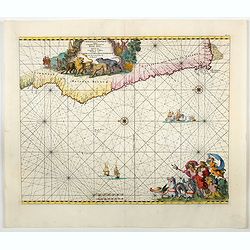
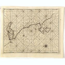
Cimbebas et Caffariae Littora a Catenbela ad Promontorium ..
A delightful Dutch sea chart that shows the coast of Angola, south-west Africa and South Africa up to Port Elizabeth. A truly classic sea chart of Dutch school with excel...
Date: Amsterdam, 1700
Selling price: ????
Please login to see price!
Sold in 2023
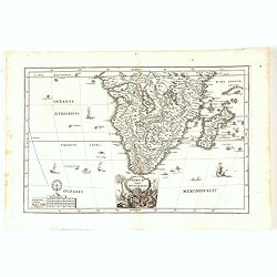
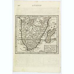
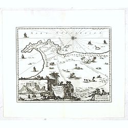
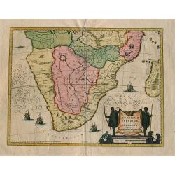
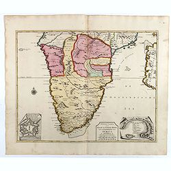
Africae Pars Australis.
Africa south of the equator. Beautiful cartouche with the title above in a scroll. Nice margins, excellent condition.
Date: Munich, 1700
Selling price: ????
Please login to see price!
Sold in 2020
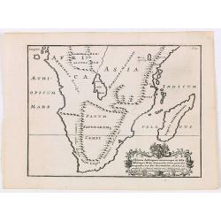
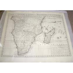
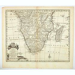
Pays, et Coste des Caffres : Empires de Monomatapa Monoemugi, &c.
Map of southern Africa. From Description de tout l'Univers, published by François Halma.
Date: Amsterdam, 1700
Selling price: ????
Please login to see price!
Sold in 2011
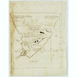
Cartes des pays et des peuples du Cap de bonne Esperance nouvellemt decouverts par les Hollandois.
French manuscript map of Cape of Good Hope, as it was at about 1670. With a key (A-C) pointing to the Dutch fortress, Table Mountain and Lion's head.
Date: France, ca. 1670-1700
Selling price: ????
Please login to see price!
Sold in 2012
Le Cap de Bonne Esperance.
Fine view of Capetown from the seaside. With numerous sailing ships in the front. Tabletop mountaion in the back. Two putti holding the title banner. A six number key exp...
Date: Leiden, c1700
Selling price: ????
Please login to see price!
Sold in 2013
Congo, Angola, Cafres, Monoemugi, Monomotapa, Zanguebar & Madagascar.
The nice map that extends from Central Africa - Congo to Mombasa to the Cape of Good Hope. Herman Moll (fl.1678-1732). was a bookseller, geographer and engraver. A native...
Date: London, ca 1701
Selling price: ????
Please login to see price!
Sold in 2019
Kabo de Bona Esperança.
Attractive view of the Good Hope Cape. A fleet of Dutch vessels is present on the foreground.
Date: Amsterdam, 1702
Selling price: ????
Please login to see price!
Sold in 2008
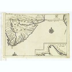
Cabo de Bona Esperanca / De Bay Van A de.S. Bras.
Uncommon small map of South Africa. From the French reissue of the account of early Dutch voyages first published in 1608 by Commelin. The French translation was carried ...
Date: Amsterdam, E. Roger, 1702
Selling price: ????
Please login to see price!
Sold in 2012
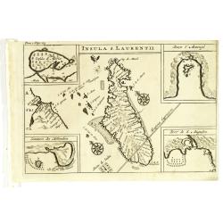
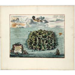
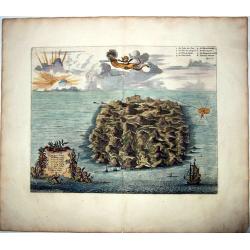
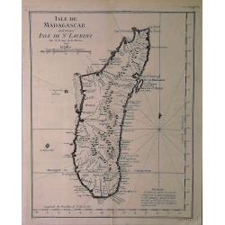
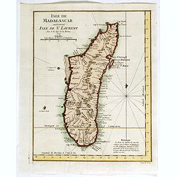
Insula S. Laurentii.
Map of Madagascar, with four inset maps. From the French reissue of the account of early Dutch voyages first published in 1608 by Commelin. The French translation was car...
Date: Amsterdam, E. Roger, 1702
Selling price: ????
Please login to see price!
Sold in 2012
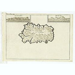
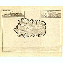
St Helene.
Uncommon small map of St. Helena, with two coastal profile inset maps.From the French reissue of the account of early Dutch voyages first published in 1608 by Commelin. T...
Date: Amsterdam, E. Roger, 1702
Selling price: ????
Please login to see price!
Sold in 2012
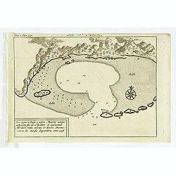
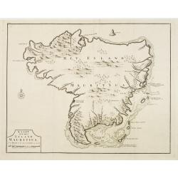
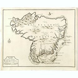
Isle St. Maurice. Ins. cygnae a Lusit, a nostris Maurity nomine indigitata, sita ad 21um gradum ab Equinoctiali Meridiem versus inventa et detecta Decima-jctava die mensis septembris anno 1598.
A bay at ST. Mauritius, a small island located in the South-West Indian Ocean, off the east coast of Madagascar. Mauritius is well known for the Dodo, the extinct bird. T...
Date: Amsterdam, E. Roger, 1702
Selling price: ????
Please login to see price!
Sold in 2021
C.D.Bona Esperance.
A rare view of a South African couple. In background Table Mountain.Engraved by A.Meijer for Carolus Allard's for his Orbis habitabilis oppida et vestitus. This rare work...
Date: Amsterdam, inbetween 1683-1702
Selling price: ????
Please login to see price!
Sold in 2012
A mapp of the Cape of Goodhope with its true Situation.
Very fine decorative map of Cape of Good Hope. From the book "A Collection of Voyages and Travels" by J. Churchill and the map came from the part containing the...
Date: London, Printed for A. and J. Churchill, 1703
Selling price: ????
Please login to see price!
Sold in 2016
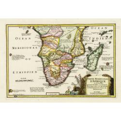
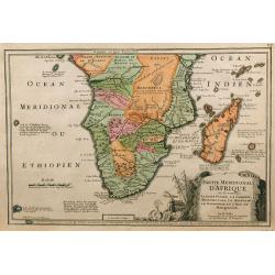
Partie méridionale d'Afrique où se trouvent la Basse Guinée, la Cafrerie, le Monomotapa, le Monoemugi, le Zanguebar et l'isle de Madagascar
The map includes Southern Africa and Madagascar. Engraved by C.Inselin.There is a small legend at the lower border describing the discovery of the Cape by Bartholomew Dia...
Date: Paris, 1705
Selling price: ????
Please login to see price!
Sold in 2011
Cap de Bonne Esperance par N.de Fer.
In the upper part a view of the Table Mountain, in lower part Table Bay and the Dutch Castle at Cape of Good Hope.
Date: Paris, 1705
Selling price: ????
Please login to see price!
Sold in 2008
Partie Meridionale d'Afrique ...
Map of southern Africa, engraved by C. Inselin, from De Fer's Atlas Curieux.
Date: Paris, 1705
Selling price: ????
Please login to see price!
Sold in 2009
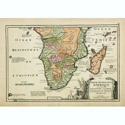
Partie méridionale d'Afrique où se trouvent la Basse Guinée, la Cafrerie, le Monomotapa, le Monoemugi, le Zanguebar et l'isle de Madagascar
The map includes Southern Africa and Madagascar. Engraved by C.Inselin.There is a small legend at the lower border describing the discovery of the Cape by Bartholomew Dia...
Date: Paris, 1705
Selling price: ????
Please login to see price!
Sold in 2018
Carte du Congo et du Pays des Cafres.
Large map of the Southern part of Africa, including Madagascar. With the imprint "Chez l’Auteur sur le Quai de l’Horloge (imprint erased after Horloge) avec Priv...
Date: Paris, January 1708
Selling price: ????
Please login to see price!
Sold in 2026
Carte du Congo et du Pays des Cafres..
Large map of the Southern part of Africa, including Madagascar An important map by one of France's most prolific map makers.The Delisle (de L'Isle) family followed the Sa...
Date: Paris, 1708
Selling price: ????
Please login to see price!
Sold in 2017
Saint Helena.
This fine hand colored original copper-plate engraved antique map of the Island of St Helena in the southern Atlantic that was published by Pieter Van der Aa. With cherub...
Date: Leiden, ca 1710
Selling price: ????
Please login to see price!
Sold in 2020
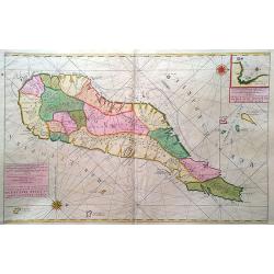
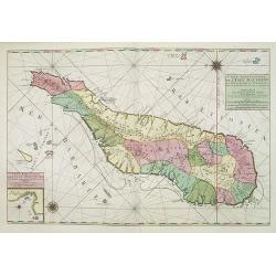
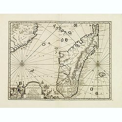
Carte particuliere de L´Isle Dauphine ou Madagascar et St Laurens.
A big, beautiful, brightly colored map of Madagascar, Comoros, I. De Bourbon, Santa Apolonia, I. Ioan de Lisboa and other islands. With an inset map of Baye St. Augustin....
Date: Amsterdam, ca. 1710
Selling price: ????
Please login to see price!
Sold in 2017
SAINT HELENA.
This fine hand colored original copper-plate engraved antique map of the Island of St Helena in the southern Atlantic, was published by Pieter Van der Aa. With cherubs, s...
Date: Amsterdam, ca 1710
Selling price: ????
Please login to see price!
Sold in 2021
Cimebebas et Caffariae Littora a Catenbela ad Promontorium Bonae Spei. Pascaerte... Gedruckt tot Amsterdam by L Renard.
A highly decorative of the southern and southwest coast of Africa including the Cape of Good Hope. A large title cartouche dominates the top of the chart. This cartouc...
Date: Amsterdam, (c.1675) 1710
Selling price: ????
Please login to see price!
Sold in 2011
Ultimae Aethiopum utrorumque in Asia Africaque Orae . . .
A uncommon map of South Africa after Pompus Mela, with Madagascar with a large cartouche lower left with dedication to Ric. Elsworth of Bickham.From "De situ orbis l...
Date: London, Philipp Bishop, 1711
Selling price: ????
Please login to see price!
Sold in 2020
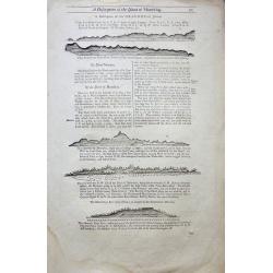
A Description of the Island of Mauritius - Don Mascarenhas Island.
No’s 23 – 24 A woodblock chart on a double sided sheet by Samuel Thornton showing the approaching coast line of Mauritius 23’ on the verso 24’ shows Don Mascarenh...
Date: London 1711
Selling price: ????
Please login to see price!
Sold in 2015
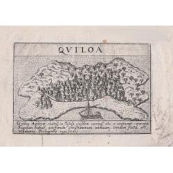
Quiloa (Kilwa - Tanzania)
A woodcut print of Quiloa (Kilwa) off the coast of Tanzania. An scarce small map of the island.
Date: Padua, 1713
Selling price: ????
Please login to see price!
Sold in 2018
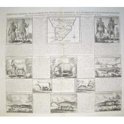
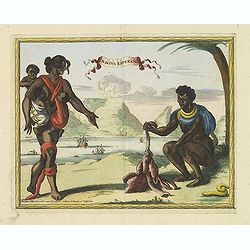
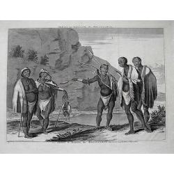
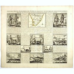
Coutumes, Moeurs et Habillemens des Peuples qui Habitent aux Environs du Cap de Bonne Esperance..
Decorative images of people & animals, with a map of southern Africa after Tachard. The people depicted are the Hottentots and the Namaquas of the Cape of Good Hope. ...
Date: Amsterdam, c. 1719
Selling price: ????
Please login to see price!
Sold in 2008
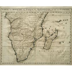
Carte du Royaume de Congo, du Monomotapa et de la Cafrerie.
A detailed map of Southern Africa. Effectively De Lisle map of 1708, this is the French version by Chatelain,with a text block at lower right describing the Congo, Monomo...
Date: Amsterdam, c.1719
Selling price: ????
Please login to see price!
Sold
Carte Du Royaume De Congo Du Monomotapa et de la Cafrerie.
A copper engraved, detailed map of South Africa and Madagascar, with extensive notes regarding the local tribes, geography, mines, rivers, mountains, etc. One of the most...
Date: Amsterdam, ca 1719
Selling price: ????
Please login to see price!
Sold in 2019
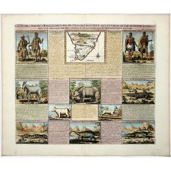
COUTUMES MOEURS & HABILLEMENS des PEUPLES QUI HABITENT AU ENVIRONS DU CAP DE BONNE ESPERANCE. . .
A decorative image of people & animals, with a map of southern Africa after Tachard. The people depicted are the Hottentots and the Namaquas of the Cape of Good Hope....
Date: Amsterdam, ca 1719
Selling price: ????
Please login to see price!
Sold in 2019
Carte particuliere de L'Isle Dauphine ou Madagascar..
An impressive large sheet of the island of Madagascar. Numerous place names, soundings and sand banks are shown round the island and the regions are defined in original ...
Date: Amsterdam 1720
Selling price: ????
Please login to see price!
Sold in 2012
Dracht en Wapening der Hottentots.
Large format view of "Hottentots" in traditional clothing and armed with spear and bow. Located at the Cape of Good Hope. Title below the view: "Les Armes ...
Date: Leiden, c1720
Selling price: ????
Please login to see price!
Sold in 2013
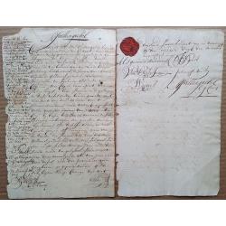
1721 Cape of Good Hope debenture, signed by 4 future COGH Governors, with intact VOC wax seal and 1714 revenue stamp.
This is a fascinating two-page document that needs further research. Written in very readable Dutch, a limited translation reveals that it seems that Jan Spoor (who is ...
Date: Cape of Good Hope, 1721
Selling price: ????
Please login to see price!
Sold in 2015
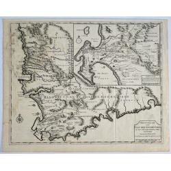
Nieuwe Kaart van Caap der Goede Hoop..
"Fine chart depicting the southern tip of Africa. Little interior detail is given but the coastlines, settlements and principal coastal features are identified. An a...
Date: Amsterdam 1724
Selling price: ????
Please login to see price!
Sold
Kaart van het eyland Mauritius.
Fine map depicting the island of Mauritius. Little interior detail is given but the coastlines, settlements and principal coastal features are identified. An attractive e...
Date: Amsterdam 1724
Selling price: ????
Please login to see price!
Sold
Nieuw Kaart van Caap Der Goede Hoop - in hare rechte jegenwoordige staat vertoond door FRANÇOIS VALENTYN.
An attractive & detailed map of the Cape region, one of the few early Dutch maps to focus on the region only some 70 years after the first Dutch settlement. Area cove...
Date: Amsterdam, 1724
Selling price: ????
Please login to see price!
Sold in 2019
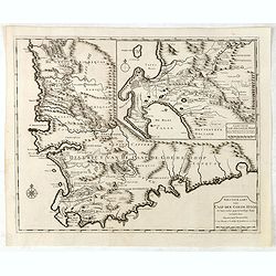
Nieuwe Kaart van Caap der Goede Hoop in hare rechte jegenwoordige staat. . .
Fine map depicting the southern tip of Africa. Little interior detail is given but the coastlines, settlements and principal coastal features are identified. In top right...
Date: Amsterdam, 1724
Selling price: ????
Please login to see price!
Sold in 2015
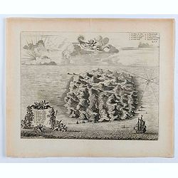
Isle St. Hélène.
This bird's eye view shows the Island of Saint Helena in the South Atlantic Ocean. With decorative title cartouche, legend / key, compass rose and ships.This plate origin...
Date: Leiden, ca. 1725
Selling price: ????
Please login to see price!
Sold in 2020
St Helene.
Uncommon small map of St. Helena, with two coastal profile inset maps.From the French reissue of the account of early Dutch voyages first published in 1608 by Commelin. T...
Date: Amsterdam, F. Bernard, 1725
Selling price: ????
Please login to see price!
Sold in 2019
Isle St. Maurice. Ins. cygnae a Lusit, a nostris Maurity nomine indigitata, sita ad 21um gradum ab Equinoctiali Meridiem versus inventa et detecta Decima-jctava die mensis septembris anno 1598.
A bay at ST. Mauritius, a small island located in the South-West Indian Ocean, off the east coast of Madagascar. Mauritius is well known for the Dodo, the extinct bird. T...
Date: Amsterdam, F. Bernard, 1725
Selling price: ????
Please login to see price!
Sold in 2019
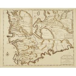
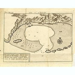
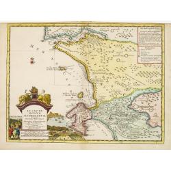
No title: Baya de Saldanha/ Cabo de Boa Esperanca.
Chart of the coast from Saldanha Bay to False Bay, the edge of the land rolled back to show the coast line in silhouette with a scale of miles and compass-rose. Marks Das...
Date: Amsterdam 1726
Selling price: ????
Please login to see price!
Sold
Geziet van Kaap der Goede Hope als men op de Reede legt.
Decorative panoramic view of the Cape of Good Hope with European vessels in the foreground.François Valentijn (1666-1727), a missionary, worked at Amboina from 1684 to 1...
Date: Amsterdam 1726
Selling price: ????
Please login to see price!
Sold
![Cape of Good Hope [no title]](/uploads/cache/15932-250x250.jpg)
Cape of Good Hope [no title]
"Plan of Cape of Good Hope with the Dutch settlements.Françcois Valentijn (1666-1727), a missionary, worked at Amboina from 1684 to 1694 and 1705 to 1713 and travel...
Date: Amsterdam 1726
Selling price: ????
Please login to see price!
Sold
Gezicht van Kaap Der Goede Hope als men op de Reede legt.
Decorative panoramic view of the town of Samboupo on the island of Celebes (Sulawesi) in today's Indonesia. Dutch (V.O.C.) sailing ships and various local craft fill the ...
Date: Amsterdam, 1726
Selling price: ????
Please login to see price!
Sold in 2017
Nieuwe Kaart van Caap de Goede Hoop in hare rechte jegenwoordige staat...
Two maps of Cape of Good Hope. . Windmills and churches are indicated on the bottom map. With inset identifying the first farm layouts, and who the farms belonged to, i...
Date: Amsterdam, 1726
Selling price: ????
Please login to see price!
Sold in 2008
![Cape of Good Hope [no title]](/uploads/cache/35902-250x250.jpg)
Cape of Good Hope [no title]
Plan of Cape of Good Hope with the Dutch settlements. A lettered key in lower right corner.François Valentijn (1666-1727), a missionary, worked at Amboina from 1684 to 1...
Date: Amsterdam, 1726
Selling price: ????
Please login to see price!
Sold in 2015
(Cabo de boa esperanca)
Chart of the Cape of Good Hope coast from Saldanha Bay to False Bay, the edge of the land rolled back to show the coast line in silhouette with a scale of miles and compa...
Date: Amsterdam, 1726
Selling price: ????
Please login to see price!
Sold in 2016
Kaart van het eyland Mauritius. . .
Fine map depicting the island of Mauritius. Little interior detail is given but the coastlines, settlements and principal coastal features are identified. An attractive e...
Date: Amsterdam, 1726
Selling price: ????
Please login to see price!
Sold in 2015
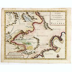
Caarte van de beyde afgelegenste colonien Drakensteen en Waveren...
Fine and early map of Colonies of Drakenstein in South Africa, from Kolbe's "Naukeurige en Uitvoerige beschryving van de Kaap de Goede Hoop".
Date: Amsterdam, 1727
Selling price: ????
Please login to see price!
Sold in 2015
Le Cap de Bonne Esperance, suivant les nouvelles observations..
Uncommon edition of this map of the Cape of Good Hope. With decorative title cartouche lower left corner.This example is unusual in having the additional separately engra...
Date: Amsterdam 1728
Selling price: ????
Please login to see price!
Sold in 2009
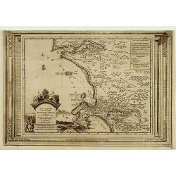
Le Cap de Bonne Esperance, suivant les nouvelles observations..
This is a small detailed map of the Cape from Saldanha to False Bay. The attractive title cartouche on the lower left is on a stone pediment surmounted by a lion and lion...
Date: Amsterdam 1728
Selling price: ????
Please login to see price!
Sold
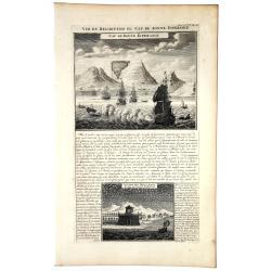
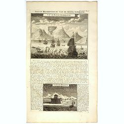
VUE et DESCRIPTION du Cap De BONNE ESPERANCE.
In top copperplate engraving of the Cape with shipping in the foreground flying the Dutch flag, with engraved descriptive text between the two views, mainly concerning th...
Date: Amsterdam, 1728
Selling price: ????
Please login to see price!
Sold in 2019
Coutumes Moeur & Habillemens..du Cap de Bonne Esperance..
In top a small map of Southern Africa (100 x 120 mm.) and 10 engravings of natives and animals of Southern Africa. In top an unusual map of Africa almost identical to tha...
Date: Amsterdam, 1728
Selling price: ????
Please login to see price!
Sold in 2018
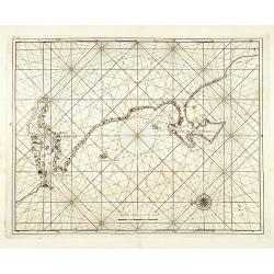
A New and Correct Chart of the Coast of Africa from Cape Negro to Cape Bona Esperance.
A rare sea chart showing a part of South Africa including the Cape of Good Hope and Table Bay. Extends to locate Tristan da Cunha and St. Helena! Published in the Atlas...
Date: London, 1728
Selling price: ????
Please login to see price!
Sold in 2016
Le Cap de Bonne Esperance, suivant les nouvelles observations..
This is a small detailed map of the Cape from Saldanha to False Bay. The attractive title cartouche on the lower left is on a stone pediment surmounted by a lion and lion...
Date: Amsterdam, 1728
Selling price: ????
Please login to see price!
Sold in 2019
Vue et Description du Cap de Bonne Espérance.
In top copperplate engraving of the Cape with shipping in the foreground flying the Dutch flag, with engraved descriptive text between the two views, mainly concerning th...
Date: Amsterdam, 1728
Selling price: ????
Please login to see price!
Sold in 2017
Ile de S. Laurens, ou Madagascar, située dans L'Ocean Ethiopien, sur les Côtes de L'Afrique.
Detailed map of Madagascar and Réunion. Published by Pieter van der Aa in "Galérie agréable du monde", completed in 1729. The Galerie was a sixty-six volume ...
Date: Leiden, 1729
Selling price: ????
Please login to see price!
Sold in 2013
Aethiopia inferior vel exterior ...
Blaeu's landmark map of Southern Africa, here in the final De Wit edition of 1695 published by Covens and Mortier ca. 1730. Blank on verso. This final print saw an almost...
Date: Amsterdam, 1730
Selling price: ????
Please login to see price!
Sold in 2008
The Present State of the Cape of Good-Hope: or a Particular Account of the Several Nations of the Hottentots...
One of the most important early accounts of South Africa and the Cape of Good Hope! “It contains the earliest list of South African animals … a full account of the go...
Date: London, 1731
Selling price: ????
Please login to see price!
Sold in 2019
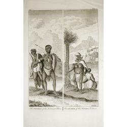
The Apparel of the Hottentot Men - The Apparel of the Hottentot Women.
An early 1731 engraving depicting the apparel of the Hottentot people of South Africa.James Mynde Engraver, working in City of London on general plates. He had a large st...
Date: London, 1731
Selling price: ????
Please login to see price!
Sold in 2012
Nieuwe caarte van Kaap de Goede Hoop en't zuyderdeel van Africa. . .
Uncommon map of Africa, south of the Equator, with insets of the Dutch fort at the Cape of Good Hope and Table Bay.Joachim Ottens (1663 - 1719) and his sons Renier and Jo...
Date: Amsterdam, 1737
Selling price: ????
Please login to see price!
Sold in 2017
![[2 Maps] Coste Occidentale d'Afrique, Depuis le Xie. Degre. . . / Carte de la Coste Orientale d'Afrique, depuis le Cap de Bonne Esperance. . .](/uploads/cache/42215-250x250.jpg)
[2 Maps] Coste Occidentale d'Afrique, Depuis le Xie. Degre. . . / Carte de la Coste Orientale d'Afrique, depuis le Cap de Bonne Esperance. . .
The first map is a detailed map featuring the southwest coast of Africa from “Cap de Bonne Esperance” (Cape of Good Hope), “Hottentots” (modern South Africa) in t...
Date: Paris, ca 1740
Selling price: ????
Please login to see price!
Sold in 2018
A New & Accurate Map of the Southern Parts of Africa containing Lower Guinea, Monoemugi. . .
A striking map of the Southern half of Africa and Madagascar, complete with a large decorative cartouche and compass rose. Tribal regions and Kingdoms named. Interesting ...
Date: London, ca 1745
Selling price: ????
Please login to see price!
Sold in 2021
Isle de Madagascar Autrement Isle de St. Laurent.
An attractive map of the island of Madagascar marking its settlements and topography, by Bellin from Prevost's "Histoire Generale des Voyages".Jacques Nicolas B...
Date: Paris, 1747
Selling price: ????
Please login to see price!
Sold in 2020
Gezigt van de Kaap de Goede-Hoop.
A small view of the Cape of Good Hope, and featuring a plan of the fort and map of the bay. There is also a numbered table (1-14) at top. Engraved when the Dutch had a co...
Date: Amsterdam, 1747
Selling price: ????
Please login to see price!
Sold in 2019
Isle de Madagascar autrement Isle de St. Laurent . . .
Detailed map of the island of Madagascar, from Jacques-Nicolas Bellin (1703-1772) the most important mapmakers of the 18th Century.
Date: Paris, 1747
Selling price: ????
Please login to see price!
Sold in 2022
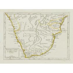
Pays des Cafres.
Charming small map of Southern Africa. From Atlas Portatif Universel, by Robert de Vaugondy.Page 82 outside border top right. Mary Sponberg Pedley does not mention a stat...
Date: Paris, later than 1748
Selling price: ????
Please login to see price!
Sold in 2023
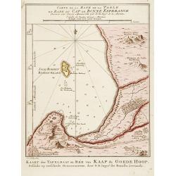
Carte de la Baye de la Table .. / Cap de Bonne Esperance.
A very nice map of the Cape of Good Hope.From Atlas Portatif pour servir a l'intelligence de l'Histoire Philosophique et Politique des etablissements et du commerce des E...
Date: Amsterdam 1749
Selling price: ????
Please login to see price!
Sold
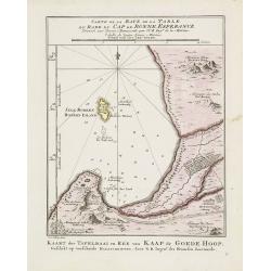
Carte de la Baye de la Table .. / Cap de Bonne Esperance.
A very nice map of the Cape of Good Hope.From Atlas Portatif pour servir a l'intelligence de l'Histoire Philosophique et Politique des etablissements et du commerce des E...
Date: Amsterdam, 1749
Selling price: ????
Please login to see price!
Sold in 2011
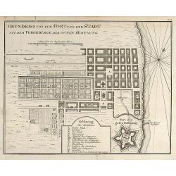
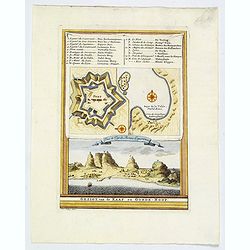
Grundriss von dem Fort und der Stadt auf dem Vorgebirge der Guten Hoffnung
Engraved map of Cape Town in South Africa by Nicolas Bellin. From the German edition of Prévost's "L'Histoire Générale des Voyages" by J. J. Schwabe in Leipz...
Date: Leipzig, 1749
Selling price: ????
Please login to see price!
Sold in 2008
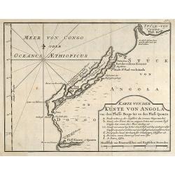
Karte von der Küste von Angola von dem Flusse Bengo bis an den Fluß Quanza.
Engraved map of the coastal line of Angola in Southwest Africa by Nicolas Bellin. From the German edition of Prévost's "L'Histoire Générale des Voyages" by J...
Date: Leipzig, 1749
Selling price: ????
Please login to see price!
Sold in 2010
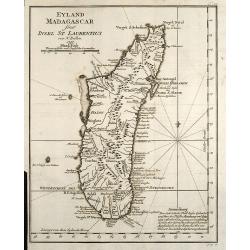
Eyland Madagascar sonst Insel St Laurentius
Engraved map of the Island of Madagascar in the Indian Ocean by Nicolas Bellin. From the German edition of Prévost's L'Histoire Générale des Voyages by J. J. Schwabe i...
Date: Leipzig, 1749
Selling price: ????
Please login to see price!
Sold in 2009
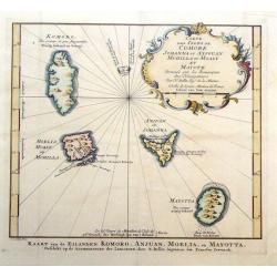
Carte des Isles de Johanna ou Anjouan Mohilla ou Moaly et Mauote.
Decorative map of the Comoros Islands to the north of Madagascar east of Africa. The map maker was N. Belin and the engraver was J. Van Der Schley.
Date: Paris, 1749
Selling price: ????
Please login to see price!
Sold in 2016
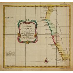
Coste Occidentale d' Afrique depuis le XIe. Degré jusqu'au Cap de Bonne Esperance.
Jaques Nicolas Bellin (1702-720) was the most important French hydrographer of the 18th century. Sea-atlas 'Hydrographique Français' , 1756-65, atlas to accompany Prévo...
Date: Paris, c. 1750
Selling price: ????
Please login to see price!
Sold
Ile Maurice Nommee Depuis Ile De France.
A fine bird's-eye view and view of the harbor of the Ile Maurice, or Mauritius, from Prevost's "Histoire Des Voyages", 1750.The mountains are covered with cloud...
Date: Paris, 1750
Selling price: ????
Please login to see price!
Sold in 2021
![[Lot of 7 map / prints of Madagascar] Parte de la Cote Orientale d' Afrique avec l' Isle de Madagascar et les Cartes particulières des Isles de France et de Bourbon.](/uploads/cache/18022-(1)-250x250.jpg)
[Lot of 7 map / prints of Madagascar] Parte de la Cote Orientale d' Afrique avec l' Isle de Madagascar et les Cartes particulières des Isles de France et de Bourbon.
A map of Madagascar with 2 insets depicting Mauritius and Réunion. and the opposite mainland of Africa, nowadays Mocambique. The area around the Zambesi river, rich in g...
Date: Paris, c. 1750
Selling price: ????
Please login to see price!
Sold in 2022
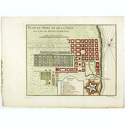
Plan du Fort et de la ville du Cap de Bonne Esperance.
Early plan of the city, the fort and Good Hope Cape. Across the top is an extensive list of 22 important sites and locations keyed to the plan with tiny letters and numbe...
Date: Paris, 1750
Selling price: ????
Please login to see price!
Sold in 2017
