Subscribe to be notified if similar examples become available.
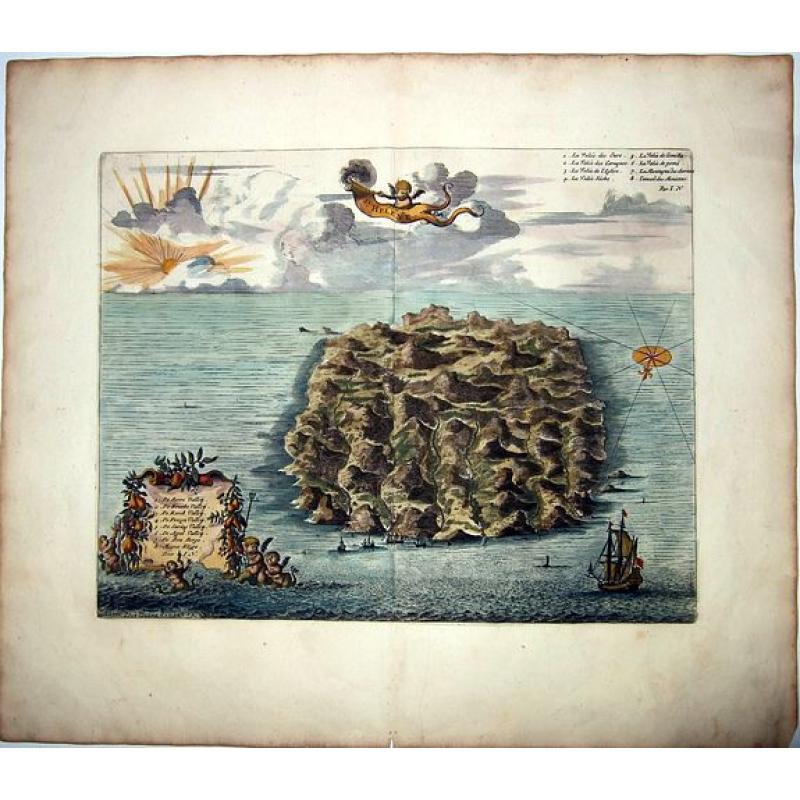
SAINT HELENA. |
||||||||||||||||||||
|
||||||||||||||||||||
|
|
||||||||||||||||||||
|
Selling price: $ Please login to see price!
Sold in 2021 Missed this item! Add your name to our mailing list and be the first to get notified about our newly added listings. . |
My Collection + - Save and collect this or any of your favorite items in one place.
If you want to save the items permanently, please sign in or create account first. |
|||||||||||||||||||
Description
This fine hand colored original copper-plate engraved antique map of the Island of St Helena in the southern Atlantic, was published by Pieter Van der Aa. With cherubs, ships and decorative embellishments.
Saint Helena is a volcanic tropical island in the South Atlantic Ocean, 4,000 kilometres east of Rio de Janeiro and 1,950 kilometres west of the Cunene River, which marks the border between Namibia and Angola in southwestern Africa. It is part of the British Overseas Territory of Saint Helena, Ascension and Tristan da Cunha. It was named after Saint Helena of Constantinople.
It is one of the most remote islands in the world, and was uninhabited when discovered by the Portuguese in 1502. It was an important stopover for ships sailing to Europe from Asia and South Africa for centuries. Napoleon was imprisoned there in exile by the British, as were Dinuzulu kaCetshwayo (for leading a Zulu army against British rule) and more than 5,000 Boers taken prisoner during the Second Boer War, including Piet Cronjé.
Between 1791 and 1833, Saint Helena became the site of a series of experiments in conservation, reforestation and attempts to boost rainfall artificially. This environmental intervention was closely linked to the conceptualisation of the processes of environmental change and helped establish the roots of environmentalism.
Pieter Van der Aa (1659–1733) was a Dutch publisher, best known for preparing maps and atlases. Despite producing his own work, van der Aa is also known for his production of pirated editions of illustrated publications and foreign bestsellers.
Beginning his career as a Latin trade publisher in Leiden in 1683, van der Aa's ambition was to one day become the most famous printer in the city. In 1715, van der Aa was appointed the head printer for Leiden and its university.
FAQ - Guarantee - Shipping
Buying in the BuyNow Gallery
This item is available for immediate purchase when a "Add to Cart" or "Inquire Now" button is shown.
Items are sold in the EU margin scheme
Payments are accepted in Euros or US Dollars.
Authenticity Guarantee
 We provide professional descriptions, condition report (based on 45 years experience in the map business)
Paulus Swaen warrants the authenticity of our items and a certificate of authenticity is provided for each acquired lot.
Condition and Coloring
We indicate the condition of each item and use our unnique HiBCoR grading system in which four key items determine a map's value: Historical Importance, Beauty, Condition/Coloring and Rarity.
Color Key
We offer many maps in their original black and white condition. We do not systematically color-up maps to make them more sellable to the general public or buyer.
Copper engraved or wood block maps are always hand colored. Maps were initially colored for aesthetic reasons and to improve readability. Nowadays, it is becoming a challenge to find maps in their original colors and are therefor more valuable.
We use the following color keys in our catalog:
Original colors; mean that the colors have been applied around the time the map was issued.
Original o/l colors; means the map has only the borders colored at the time of publication.
Colored; If the colors are applied recently or at the end of the 20th century.
Read more about coloring of maps [+]
Shipping fee
A flat shipping fee of $ 30 is added to each shipment by DHL within Europe and North America. This covers : International Priority shipping, Packing and Insurance (up to the invoice amount).
Shipments to Asia are $ 40 and rest of the world $50
We charge only one shipping fee when you have been successful on multiple items or when you want to combine gallery and auction purchases.
Read more about invoicing and shipping
FAQ
Please have a look for more information about buying in the BuyNow gallery
Many answers are likely to find in the general help section.
My Collection+
![]()
With My Collection+ you can collect all your favorite items in one place. It is free, and anyone can create his or her virtual collection.
Unless you are logged in, the item is only saved for this session. You have to be registed and logged-in if you want to save this item permanently to My Collection+.
Read More[+]
Register here, it is free and you do not need a credit card.
Add this item to
My Collection+
or click the following link to see My Collection+.
| Digital Image Download | |
|
Paulus Swaen maintains an archive of most of our high-resolution rare maps, prints, posters and medieval manuscript scans. We make them freely available for download and study. Read more about free image download |
Click the image for a free small image download. |
In accordance with the EU Consumer Rights Directive and habitually reside in the European Union you have the right to cancel the contract for the purchase of a lot, without giving any reason.
The cancellation period will expire 14 calendar days from the day after the date on which you or a third party (other than the carrier and indicated by you) acquires, physical possession of the lot. To exercise the right to cancel you must inform Paulus Swaen Inc, of your decision to cancel this contract by a clear statement (e.g. a letter sent by post, or e-mail (amsterdam@swaen.com).
To meet the cancellation deadline, it is sufficient for you to send your communication concerning your exercise of the right to cancel before the cancellation period has expired.
