Browse Listings in Africa > Southern Africa > Southern Africa
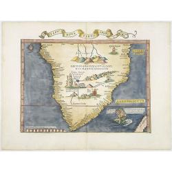
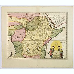
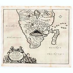
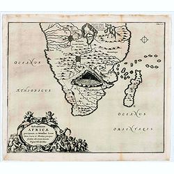
Tabu nova partis aphri.
Ptolemy's double-page wood-engraved map of southern Africa. The map is a derivative of the Waldseemüller map of 1513, with the addition of three kings on their thrones, ...
Date: Lyons, M. Servetus, 1535
Selling price: ????
Please login to see price!
Sold
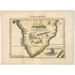
Tabula nova partis Africae.
Wood block printed map of southern part of Africa, the second earliest map to focus on the southern part of the Continent. The map is prepared by Lorenz Fries after Marti...
Date: Vienna, Trechsel, G., 1525 -1541
Selling price: ????
Please login to see price!
Sold
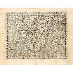
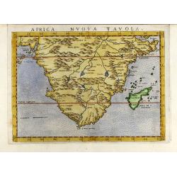
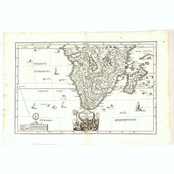
An early map of 'modern' southern Africa: Africa Nova Tabula.
An uncommon map showing all of Africa from the Horn of Africa and the Bight of Benin southward to the Cape of Good Hope. The information to produce this map was based on...
Date: Venice, 1548
Selling price: ????
Please login to see price!
Sold in 2011
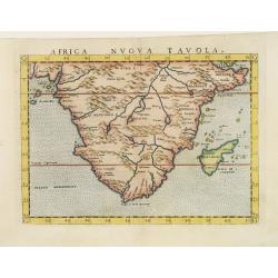
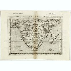
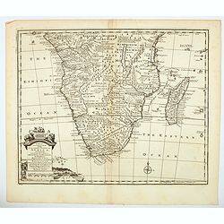
Africa nuova tavola.
Uncommon first edition of this early map of south Africa. Madagascar is called Isola de S. Lorenzo and is oddly shaped.The origin of the Nile conforms to the Ptolemaic co...
Date: Venice, 1561
Selling price: ????
Please login to see price!
Sold
Africa nuova tavola
Decorative colored 16th century map of South Africa by G. Ruscelli. From the latin Ptolemy edition of Gastaldi-Ruscelli by V. Valgrisi, printed in Venice 1562.
Date: Venice, 1562
Selling price: ????
Please login to see price!
Sold in 2009
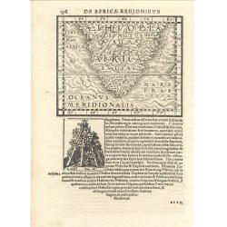
De Africae Regionibus
Munster's uncommon woodcut map of Southern Africa. Although numerous editions of the Cosmography were printed over the span of 50 years, this map appeared in only one edi...
Date: Basle, 1572
Selling price: ????
Please login to see price!
Sold
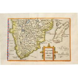
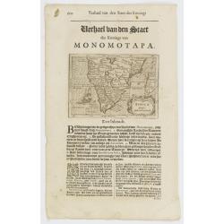
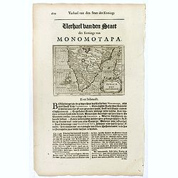
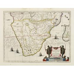
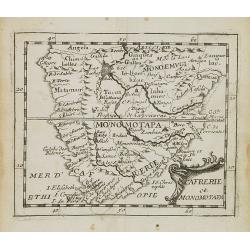
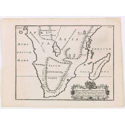
Regnum Monomotapae.
Metellus Rare Map of Southern Africa, from a 1598 Latin edition of Botero's "Theatrum Principum Orbis Universi". Modelled on the southern section of Mercator's ...
Date: Cologne, 1598
Selling price: ????
Please login to see price!
Sold in 2008
Africa Nuova Tavola.
Fine 1598 edition of this early map of southern Africa. Girolamo Ruscelli first published the map in his "La Geographi di Claudio Tolomeo" (Venice, 1561), with ...
Date: Venice, 1598
Selling price: ????
Please login to see price!
Sold in 2021
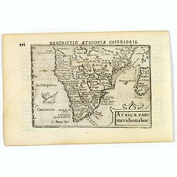
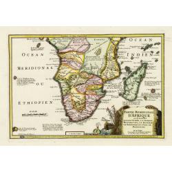
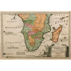
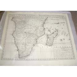
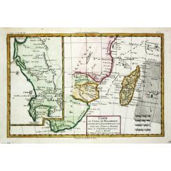
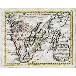
Africae pars meridionalior.
A fine miniature map of central and southern Africa, published by Petrus Bertius in Amsterdam early in the seventeenth century. The lovely map and has a strap-work title,...
Date: Amsterdam, 1606
Selling price: ????
Please login to see price!
Sold in 2019
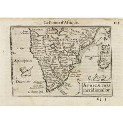
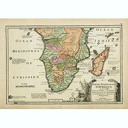
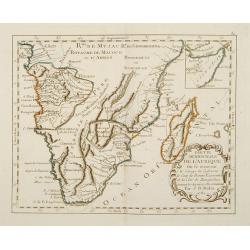
Africae Pars Meridionalior.
Very fine early miniature map of southern Africa, including also Madagascar. Title cartouche on the lower right corner : a sea monster is depicted.First published in 1598...
Date: Amsterdam/Frankfurt 1609
Selling price: ????
Please login to see price!
Sold
![[Fishes / Birds].](/uploads/cache/37967-250x250.jpg)
[Fishes / Birds].
Text engraving with lettered key (A-I) showing fishes and birds, whale and Dutch vessels seen around the costs of Southern Africa from "Premier livre de l'histoire d...
Date: Amsterdam, Cornille Nicolas, 1609
Selling price: ????
Please login to see price!
Sold in 2017
Africae pars meridional.
Small map illustrating the southern part of Africa, surrounded by text in Dutch.Nicolaes de Clerck (de Klerc) was active as engraver and publisher in Delft from 1599-1621...
Date: Amsterdam, Cloppenburch, 1621
Selling price: ????
Please login to see price!
Sold
Africae pars meridional.
Small map illustrating the southern part of Africa, surrounded by text in Dutch.Nicolaes de Clerck (de Klerc) was active as engraver and publisher in Delft from 1599-1621...
Date: Amsterdam, Cloppenburch, 1621
Selling price: ????
Please login to see price!
Sold in 2016
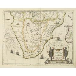
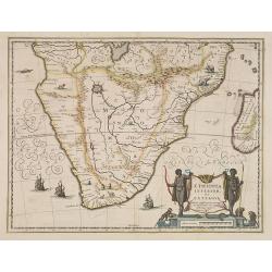
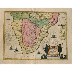
Aethiopia inferior, vel exterior.
The standard map of South Africa throughout the 17th century. The lake out of which the 'Zambere' -the Zambesi- flows is probably based on reports of Lake Ngami, undiscov...
Date: Amsterdam, 1638
Selling price: ????
Please login to see price!
Sold
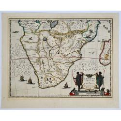
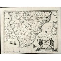
Aethiopia inferior, vel exterior. 

The standard map of South Africa throughout the 17th century. The lake out of which the 'Zambere' - the Zambesi flows is probably based on reports of Lake Ngami, undiscov...
Date: Amsterdam, 1638
Selling price: ????
Please login to see price!
Sold in 2019
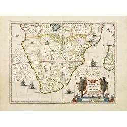
Aethiopia inferior, vel exterior.
The standard map of South Africa throughout the 17th century. The lake out of which the 'Zambere' -the Zambesi- flows is probably based on reports of Lake Ngami, undiscov...
Date: Amsterdam 1640
Selling price: ????
Please login to see price!
Sold
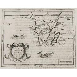
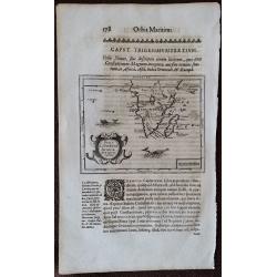
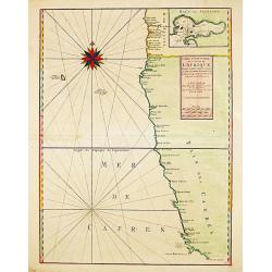
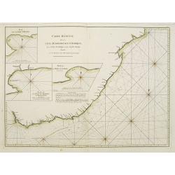
Pars Litorum Africae Antiquis ignota.
Claude Morisot's Scarce Map of the Cape of Good Hope. Map in page of text from Claude Barthélemy Morisot: Orbis Maritimi sive rerum in mari et littoribus gestarum genera...
Date: Dijon, 1643
Selling price: ????
Please login to see price!
Sold in 2008
Pars Litorum Africae Antiquis ignota.
A map 13.0 x 16.0 cm.(5.1 x 6.3 inches) set in a page of text from Claude Barthélemy Morisot: Orbis Maritimi sive rerum in mari et littoribus gestarum generalis historia...
Date: Dijon, 1643
Selling price: ????
Please login to see price!
Sold in 2015
Aethiopia inferior, vel exterior.
The standard map of South Africa throughout the 17th century. The lake out of which the 'Zambere' -the Zambesi- flows is probably based on reports of Lake Ngami, undiscov...
Date: Amsterdam 1645
Selling price: ????
Please login to see price!
Sold
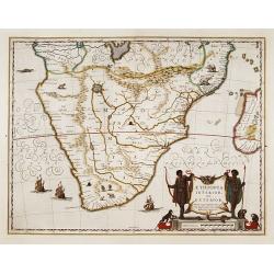
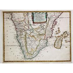
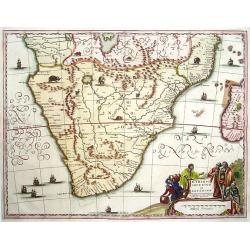
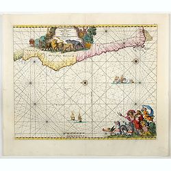
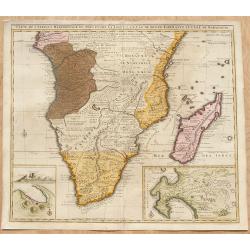
Aethiopia Inferior vel Exterior Monomotapa...
Very attractive and decorative double page map of the southern half of Africa. This map is an reduced version of the Bleau and Jansson maps. The area shown is from the Co...
Date: Frankfurt ca. 1645
Selling price: ????
Please login to see price!
Sold
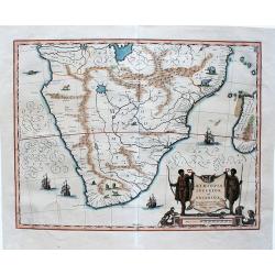
Aethiopia inferior, vel exterior.
A very decorative, large map of South Africa, which became the standard delineation of the region throughout the 17th century. The lake from which the 'Zambere' (the Zamb...
Date: Amsterdam, 1645
Selling price: ????
Please login to see price!
Sold in 2020
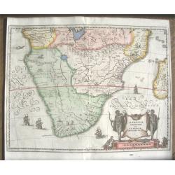
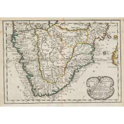
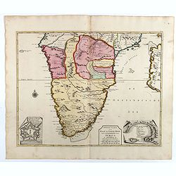
Aethiopia Inferior vel Exterior.
The standard map of South Africa throughout the 17th century. The map covers an area from Congo-Zanzibar to the Cape. It was published before Van Riebeeck settled at the ...
Date: Amsterdam, 1639-1649
Selling price: ????
Please login to see price!
Sold in 2014
Aethiopia Inferior vel Exterior Monomotapa
Nice engraved map of South Africa from M. Merian based on the Blaeu map. With a beautiful cartouche with turtles and monkeys. With several ships and animals.
Date: Frankfurt, 1650
Selling price: ????
Please login to see price!
Sold in 2009
Aethiopie, qui Compren les Royaume de Congo, Coste et Pays des Cafres, Empires du Monomotapa et Monoemugi...Par N. Sanson... A Paris Chez P. Marieete...1655. I Somer Pruthenis sculp.
Nicolas Sanson (1600-67), 'father of the French cartography' and founder of the Sanson firm. Atlas ' Cartes générales de toutes les parties du Monde', 1658-70 and a poc...
Date: Paris, P. Mariette, 1655
Selling price: ????
Please login to see price!
Sold in 2017
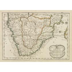
Pays, et Coste des Caffres: Empires du Monomotapa Monoemugi, &c.
Map of South Africa, from the first edition of the atlas L'Afrique en plusieurs cartes nouvelles, et exactes; & en divers traictés de Géographie, et d'Histoire.Nico...
Date: Paris, 1657
Selling price: ????
Please login to see price!
Sold in 2014
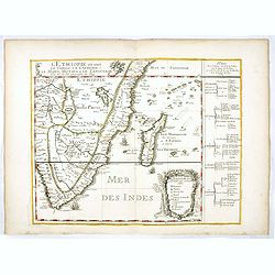
Aethopia Superior vel Inferior vulgo Abissinorum sive.
An attractive map of Eastern Africa and the fictitious kingdom of Prester John. The map shows a large section of central and eastern Africa including Mozambique north to ...
Date: Amsterdam, ca 1657
Selling price: ????
Please login to see price!
Sold in 2018
Aethiopia inferior, vel exterior.
The standard map of South Africa throughout the 17th century. The lake out of which the 'Zambere' -the Zambesi- flows is probably based on reports of Lake Ngami, undiscov...
Date: Amsterdam, 1658
Selling price: ????
Please login to see price!
Sold in 2016
L'Empire du Monomotapa et coste des Caffres. (15).
Scarce map of Southern Africa published by Antoine de Fer in 1661 or 1662 in "Cartes de géographie revues et augmentées". With number 15 in lower right bottom...
Date: Paris, Antoine de Fer, 1657 but 1661 or 1662
Selling price: ????
Please login to see price!
Sold in 2018
Cafrerie et Monomotapa.
Rare first state, 1663. While this map is generally well known from the 1676 edition, this first state, dated from the title page 1663 is rare. Table Bay isn\'t labeled,...
Date: Paris, 1663
Selling price: ????
Please login to see price!
Sold in 2008
Hydrophylacium Africae precipuum, in montibus lunae situm.
Rare and Interesting map showing the sources of the Nile in a cavern beneath the Mountains of the Moon. From Kircher's "Mundus Subterranaeus". Top right Tomus I...
Date: Amsterdam, 1665
Selling price: ????
Please login to see price!
Sold in 2020
Hydrophylacium Africae precipuum, in montibus lunae situm.
Rare and Interesting map showing the sources of the Nile in a cavern beneath the Mountains of the Moon. From Kircher's "Mundus Subterranaeus". Top right Tomus ...
Date: Amsterdam, 1665
Selling price: ????
Please login to see price!
Sold in 2022
Pays et Coste des Caferes: Empres du Monomotapa Monoemugi. . .
Map of Southern Africa prepared by N.Sanson and published by Pierre Mariette.Published in an early edition of the small Sanson atlas L'Europe Dediée a Monseigneur . . . ...
Date: Paris, P. Mariette, 1667
Selling price: ????
Please login to see price!
Sold in 2008
Aethiopia inferior vel Exterior.
The standard map of South Africa throughout the 17th century covering the region from Congo-Zanzibar to the Cape. Based on the map of Portuguese exploration and most deta...
Date: Amsterdam 1670
Selling price: ????
Please login to see price!
Sold
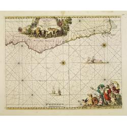
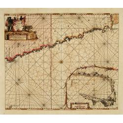
Cimbebas et Caffariae Littora a Catenbela ad Promontorium..
The coast of Angola, South-West Africa and South Africa up to Port Elizabeth. Classic sea chart of Dutch school with excellent baroque embellishment. North oriented to th...
Date: Amsterdam, 1675
Selling price: ????
Please login to see price!
Sold in 2008
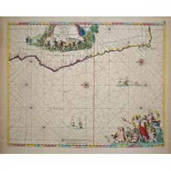
Cimbebas et Caffariae Littora a Catenbela ad Promontorium..
The coast of Angola, South-West Africa and South Africa up to Port Elizabeth. Classic sea chart of Dutch school with excellent baroque embellishment. North oriented to th...
Date: Amsterdam, 1675
Selling price: ????
Please login to see price!
Sold in 2010
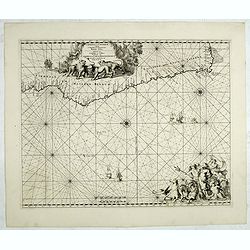
Cimbebas et Caffariae Littora a Catenbela ad Promontorium. . .
The coast of Angola, South-West Africa and South Africa up to Port Elizabeth. Classic sea of Dutch school with excellent baroque embellishment. North oriented to the lef...
Date: Amsterdam, 1675
Selling price: ????
Please login to see price!
Sold in 2014
Cafrerie et Monomotapa.
Uncommon miniature map of South Africa from Pierre Duval's "La Geographie Universeille" dated 1676. Following his Cartes de geographie in 1657, Pierre Duval pub...
Date: Paris, 1676
Selling price: ????
Please login to see price!
Sold in 2008
Paskaert Vertoonende van Cambebas en Caffaria streckende van Monte Negro tot Beooste Cabo de Bona Esperanca.
Extremely rare sea chart of the south west coast of Africa, south till Cape of Good Hope. With inset chart of Tafel Bay.
Date: Amsterdam 1683
Selling price: ????
Please login to see price!
Sold
L'Ethiopieoù sont le Congo, La Cafrerie, Le Mono-Montapa et le Zanguebar.
Scarce map of the Southern part of Africa, including Madagascar, etc. Published by Pierre Du Val, who was "geographe de Roy.". Engraved by R. Michault.Part of a...
Date: Paris, 1684
Selling price: ????
Please login to see price!
Sold
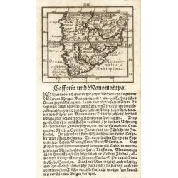
Caffraria und Monomotapa.
A miniature map of the southern part of Africa from the uncommon "Kurtzbuendige abbild-und vorstellung der gantzen weld". Johann Ulrich Müller?s (1633-1715) pu...
Date: Ulm, 1692
Selling price: ????
Please login to see price!
Sold
Pays, et Coste des Caffres : Empires de Monomatapa Monoemugi, &c.
Map of southern Africa. From Description de tout l'Univers, published by François Halma.
Date: Amsterdam, 1700
Selling price: ????
Please login to see price!
Sold in 2011
Carte Particuliere des Costes de l ' Afrique depuis Cabo Ledi jusques au Cap de Bone Esperance.
Carte Particuliere des Costes de l ' Afrique depuis Cabo Ledi jusques au Cap de Bone Esperance. Pieter Mortier (1661-1711), Amsterdam bookseller and printer of French des...
Date: Amsterdam, 1700
Selling price: ????
Please login to see price!
Sold in 2020
Africae Pars Australis.
Africa south of the equator. Beautiful cartouche with the title above in a scroll. Nice margins, excellent condition.
Date: Munich, 1700
Selling price: ????
Please login to see price!
Sold in 2020
![[Lot of 9 maps / prints of SOUTH AFRICA] Carte du Congo et du Pays des Cafres.](/uploads/cache/19581-(1)-250x250.jpg)
[Lot of 9 maps / prints of SOUTH AFRICA] Carte du Congo et du Pays des Cafres.
Guillaume de l 'Isle's influential map of South Africa. Guillaume de l' Isle (1675-1724), Royal Geographer, was the most influential cartographer of the first quarter of ...
Date: Paris, c. 1700
Selling price: ????
Please login to see price!
Sold in 2022
Cimbebas et Caffariae Littora a Catenbela ad Promontorium ..
A delightful Dutch sea chart that shows the coast of Angola, south-west Africa and South Africa up to Port Elizabeth. A truly classic sea chart of Dutch school with excel...
Date: Amsterdam, 1700
Selling price: ????
Please login to see price!
Sold in 2023
Partie méridionale d'Afrique où se trouvent la Basse Guinée, la Cafrerie, le Monomotapa, le Monoemugi, le Zanguebar et l'isle de Madagascar
The map includes Southern Africa and Madagascar. Engraved by C.Inselin.There is a small legend at the lower border describing the discovery of the Cape by Bartholomew Dia...
Date: Paris, 1705
Selling price: ????
Please login to see price!
Sold in 2011
Partie Meridionale d'Afrique ...
Map of southern Africa, engraved by C. Inselin, from De Fer's Atlas Curieux.
Date: Paris, 1705
Selling price: ????
Please login to see price!
Sold in 2009
Partie méridionale d'Afrique où se trouvent la Basse Guinée, la Cafrerie, le Monomotapa, le Monoemugi, le Zanguebar et l'isle de Madagascar
The map includes Southern Africa and Madagascar. Engraved by C.Inselin.There is a small legend at the lower border describing the discovery of the Cape by Bartholomew Dia...
Date: Paris, 1705
Selling price: ????
Please login to see price!
Sold in 2018
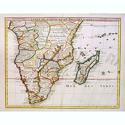
Carte du Congo et du Pays des Cafres..
Large map of the Southern part of Africa, including Madagascar An important map by one of France's most prolific map makers.The Delisle (de L'Isle) family followed the Sa...
Date: Paris, 1708
Selling price: ????
Please login to see price!
Sold in 2017
Cimebebas et Caffariae Littora a Catenbela ad Promontorium Bonae Spei. Pascaerte... Gedruckt tot Amsterdam by L Renard.
A highly decorative of the southern and southwest coast of Africa including the Cape of Good Hope. A large title cartouche dominates the top of the chart. This cartouc...
Date: Amsterdam, (c.1675) 1710
Selling price: ????
Please login to see price!
Sold in 2011
Ultimae Aethiopum utrorumque in Asia Africaque Orae . . .
A uncommon map of South Africa after Pompus Mela, with Madagascar with a large cartouche lower left with dedication to Ric. Elsworth of Bickham.From "De situ orbis l...
Date: London, Philipp Bishop, 1711
Selling price: ????
Please login to see price!
Sold in 2020
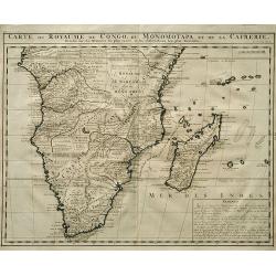
Carte du Royaume de Congo, du Monomotapa et de la Cafrerie.
A detailed map of Southern Africa. Effectively De Lisle map of 1708, this is the French version by Chatelain,with a text block at lower right describing the Congo, Monomo...
Date: Amsterdam, c.1719
Selling price: ????
Please login to see price!
Sold
Carte Du Royaume De Congo Du Monomotapa et de la Cafrerie.
A copper engraved, detailed map of South Africa and Madagascar, with extensive notes regarding the local tribes, geography, mines, rivers, mountains, etc. One of the most...
Date: Amsterdam, ca 1719
Selling price: ????
Please login to see price!
Sold in 2019
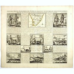
Coutumes Moeur & Habillemens..du Cap de Bonne Esperance..
In top a small map of Southern Africa (100 x 120 mm.) and 10 engravings of natives and animals of Southern Africa. In top an unusual map of Africa almost identical to tha...
Date: Amsterdam, 1728
Selling price: ????
Please login to see price!
Sold in 2018
Aethiopia inferior vel exterior ...
Blaeu's landmark map of Southern Africa, here in the final De Wit edition of 1695 published by Covens and Mortier ca. 1730. Blank on verso. This final print saw an almost...
Date: Amsterdam, 1730
Selling price: ????
Please login to see price!
Sold in 2008
The Present State of the Cape of Good-Hope: or a Particular Account of the Several Nations of the Hottentots...
One of the most important early accounts of South Africa and the Cape of Good Hope! “It contains the earliest list of South African animals … a full account of the go...
Date: London, 1731
Selling price: ????
Please login to see price!
Sold in 2019
Nieuwe caarte van Kaap de Goede Hoop en't zuyderdeel van Africa. . .
Uncommon map of Africa, south of the Equator, with insets of the Dutch fort at the Cape of Good Hope and Table Bay.Joachim Ottens (1663 - 1719) and his sons Renier and Jo...
Date: Amsterdam, 1737
Selling price: ????
Please login to see price!
Sold in 2017
A New & Accurate Map of the Southern Parts of Africa containing Lower Guinea, Monoemugi. . .
A striking map of the Southern half of Africa and Madagascar, complete with a large decorative cartouche and compass rose. Tribal regions and Kingdoms named. Interesting ...
Date: London, ca 1745
Selling price: ????
Please login to see price!
Sold in 2021
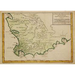
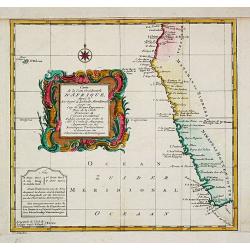
Pays des Cafres.
Charming small map of Southern Africa. From Atlas Portatif Universel, by Robert de Vaugondy.Page 82 outside border top right. Mary Sponberg Pedley does not mention a stat...
Date: Paris, later than 1748
Selling price: ????
Please login to see price!
Sold in 2023
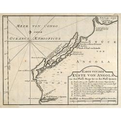
Karte von der Küste von Angola von dem Flusse Bengo bis an den Fluß Quanza.
Engraved map of the coastal line of Angola in Southwest Africa by Nicolas Bellin. From the German edition of Prévost's "L'Histoire Générale des Voyages" by J...
Date: Leipzig, 1749
Selling price: ????
Please login to see price!
Sold in 2010
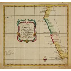
Coste Occidentale d' Afrique depuis le XIe. Degré jusqu'au Cap de Bonne Esperance.
Jaques Nicolas Bellin (1702-720) was the most important French hydrographer of the 18th century. Sea-atlas 'Hydrographique Français' , 1756-65, atlas to accompany Prévo...
Date: Paris, c. 1750
Selling price: ????
Please login to see price!
Sold
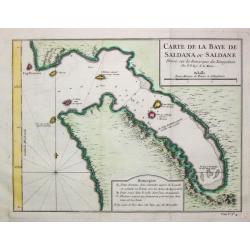
Carte de la Baye de Saldana ou Saldane.
Jaques Nicolas Bellin (1702-720) was the most important French hydrographer of the 18th century. Sea-atlas 'Hydrographique Français' , 1756-65, atlas to accompany Prévo...
Date: Paris, c. 1750
Selling price: ????
Please login to see price!
Sold in 2020
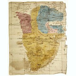
(Cape of Good Hope manuscript map)
Dutch manuscript map of South Africa, with text in Dutch. Showing mountains, rivers, town names and Kingdoms. Fine manuscript map of Southern Africa full of information, ...
Date: Netherlands, ca. 1750
Selling price: ????
Please login to see price!
Sold in 2023
![[Lot of 7 map / prints of Madagascar] Parte de la Cote Orientale d' Afrique avec l' Isle de Madagascar et les Cartes particulières des Isles de France et de Bourbon.](/uploads/cache/18022-(1)-250x250.jpg)
[Lot of 7 map / prints of Madagascar] Parte de la Cote Orientale d' Afrique avec l' Isle de Madagascar et les Cartes particulières des Isles de France et de Bourbon.
A map of Madagascar with 2 insets depicting Mauritius and Réunion. and the opposite mainland of Africa, nowadays Mocambique. The area around the Zambesi river, rich in g...
Date: Paris, c. 1750
Selling price: ????
Please login to see price!
Sold in 2022
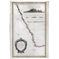
![Carte Reduite D'Une Partie Des Costes Occidentales et Meridionales De L'Afrique Depuis Cabo Frio ou Cap Froid . . . Jusque a la Bay S. Blaise . . . MDCCLIV [with view of Cape of Good Hope]](/uploads/cache/31261-250x250.jpg)
Carte Reduite D'Une Partie Des Costes Occidentales et Meridionales De L'Afrique Depuis Cabo Frio ou Cap Froid . . . Jusque a la Bay S. Blaise . . . MDCCLIV [with view of Cape of Good Hope]
Very large and detailed of the southern African coastline from Cape Fria in Namibia to Cape Agulhas. In lower left corner a rococo title cartouche and in top a profile o...
Date: Paris, Dépôt de la Marine, c.1754
Selling price: ????
Please login to see price!
Sold in 2011
Carte Reduite d'Une Partie Des Costes Occidentales et Meridionales de l'Afrique.
A fine, beautiful colored sea chart of the Southwest Coast of Africa, published by Nicolas Bellin. With three insets showing vies of "Vue du Cap de Bonne Esperance&q...
Date: Paris, 1754
Selling price: ????
Please login to see price!
Sold in 2020
Le Pays des Hottentots.
Jaques Nicolas Bellin (1702-720) was the most important French hydrographer of the 18th century. Sea-atlas 'Hydrographique Français' , 1756-65, atlas to accompany Prévo...
Date: Paris, c. 1755
Selling price: ????
Please login to see price!
Sold in 2018
Carte de la Coste Occidentale d' Afrique depuis le XIe. Degré jusqu'au Cap de Bonne Esperance.
A map of the west coast of South Africa with the Cape of Good Hope. With a nice title-cartouche. From a Dutch edition of Prevost's "Voyages".Jacques Nicolas Bel...
Date: Amsterdam, c. 1760
Selling price: ????
Please login to see price!
Sold in 2020
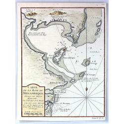
Carte de la Baye de Mosambique, Dressee sur Divers Manuscrits
A fine map of the Bay of Mozambique by Belling in Paris in 1763.Jaques Nicolas Bellin (1702-1772) was the most important French hydrographer of the 18th century. Some of ...
Date: Paris, 1763
Selling price: ????
Please login to see price!
Sold in 2016
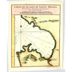
Carte de la Baye de Sainte Helene
An attractive outline chart of the coast of St Helena Bay, northwest of Cape Town, on the Atlantic coast of South Africa, by Bellin, the leading French hydrographer of th...
Date: Paris, 1764
Selling price: ????
Please login to see price!
Sold in 2016
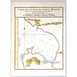
Carte de la Baye de Sainte Helene.
A map of St. Helena Bay on the Atlantic coast of South Africa. From the Dutch edition of Prevost's' Voyages'.Jaques Nicolas Bellin (1702-1772) was the most important Fren...
Date: Paris, 1764
Selling price: ????
Please login to see price!
Sold in 2016
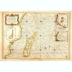
Carte réduite du canal de Mozambique et des isles de Madagascar de France de Bourbon, de Rodrigues et autres. . .
Very large and detailed chart depicting Southern Africa, with Insets: Plan de l'isle de l'Assomption et de son mouillage. -- Plan du port de Secheyles dans l'isle de ce n...
Date: Paris, ca. 1768
Selling price: ????
Please login to see price!
Sold in 2014
Carte du canal de Mosambique, contenant l' Isle de Madagascar avec les Côtes d' Afrique depuis le Cap de Bonne Esperance jusqu'a Melinde
Rigobert Bonne (1727-1795), French cartographer. His maps are found in a.o. Atlas Moderne (1762), Raynal's Histoire Philos. du Commerce des Indes (1774) and Atlas Encyclo...
Date: Paris, c. 1770
Selling price: ????
Please login to see price!
Sold
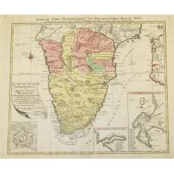
Africae Pars Meridionalis.
There are three detailed insets : the Cape Fort, Saldanda Bay and the Cape of Good Hope, all with a detailed identifying legend.
Date: Augsburg, 1770
Selling price: ????
Please login to see price!
Sold in 2008
Carte Réduite de l'Océan Orientale qui Contient la Côte d'Afrique, Avec l'Isle Madagascar et les Isles adjacentes.
French of South Africa with Cape Town and part of the south east coast . Insets of "Mossel Bay", "Plan de la rade st.Blaise" and "Plan de la Bay...
Date: Paris, Brest, chez Demonville, 1775
Selling price: ????
Please login to see price!
Sold in 2013
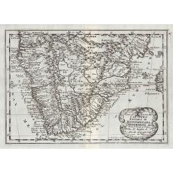
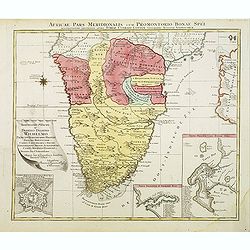
Africae Pars Meridionalis cum Promontorio Bonae Spei Accuratissime Delineato
A map of Southern Africa by T.Lotter [1717-1777]. The coastline still provides inaccurate information, while Hottentot tribes are illustrated throughout the mainland. The...
Date: Vienna, 1778
Selling price: ????
Please login to see price!
Sold
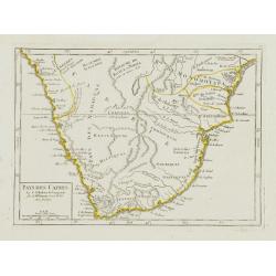
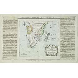
Partie Meridionale de L'Afrique.
An uncommon map of southern Africa, not listed in Tooley or Norwich. Scarce info on the interior, also has an inset of the horn of Africa top right. Large cartouche with...
Date: Paris, 1781
Selling price: ????
Please login to see price!
Sold
Partie Méridionale de l'Afrique Ou se trouvent le Congo la Cafrerie le Cap de Bonne Espérance et la Côte de Zanguébar..
A rare map depicts Southern Africa from Mombasa on the east coast south to the Cape, and Isle St. Thomas on the west side, at the Equator southward to approximately 35deg...
Date: Paris, 1783
Selling price: ????
Please login to see price!
Sold
Carte de l'Afrique Méridionale, ou Pays entre la Ligne et le Cap de Bonne Espérance.
Africa south of the Equator, with insets of Table Mountain, Table Bay and the Cape of Good Hope (based on Valentyn). Originally the plate of De L'Isle of 1708, this image...
Date: Amsterdam, ca. 1785
Selling price: ????
Please login to see price!
Sold in 2008
Partie de L'Afrique..
Map showing Southern part of Africa. Left and right box with geographical information for each part country on the continent.Prepared by Louis Brion de la Tour and publis...
Date: Paris 1790
Selling price: ????
Please login to see price!
Sold in 2009
