Browse Listings in Africa > North Africa > Morocco
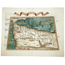
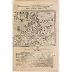
TABULA PRIMA APHRICE.
An engraved map of Africa from the blocks of Laurent Fries, the famous physician, astrologer and geographer. The map covers northwestern Africa showing the regions that w...
Date: Strasbourg, 1525
Selling price: ????
Please login to see price!
Sold in 2019
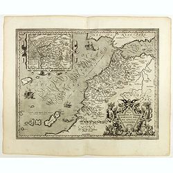
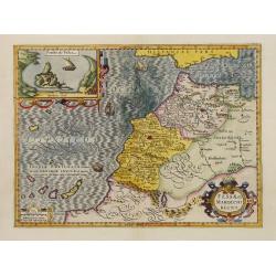
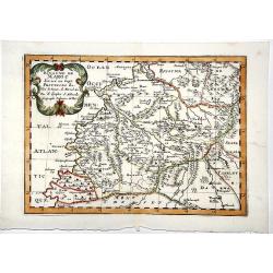
Fessae et Marocchi regna Africae celeberr.
Uncommon map, covering north-western Africa, with the Canaries and Madeira. With an inset of the Congo, after Filippo Pigafetta's famous map of the kingdom. Dare to go...
Date: Antwerp, 1598
Selling price: ????
Please login to see price!
Sold in 2020
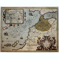
Fessae, et Marocchi Regna Africae Celeberr. describebat Abrah. Ortelius. 1595.
Uncommon map, covering north-western Africa, with the Canaries and Madeira. With an inset of the Congo, after Filippo Pigafetta's famous map of the kingdom.
Date: Antwerp, 1602
Selling price: ????
Please login to see price!
Sold in 2017
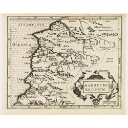
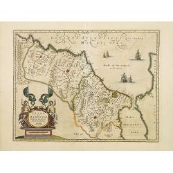
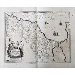
Marocchi regnum.
Miniature map showing Morocco. Decorated with two strap work cartouches. Mountains, cities and forests fill the land. The capital city of Marruecos (Marrakech) in the cen...
Date: Amsterdam 1607
Selling price: ????
Please login to see price!
Sold in 2011
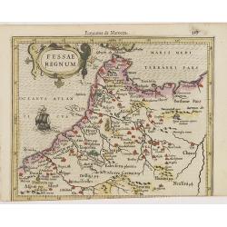
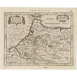
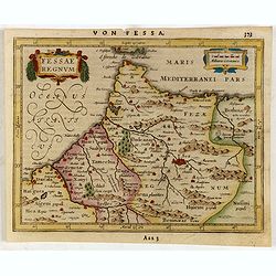
Fessae Regnum.
Charming small map of the northeast tip of Africa with Fez showing as the principal city. Decorative title cartouche.From the first French-text edition of Jodocus Hondius...
Date: Amsterdam, 1608
Selling price: ????
Please login to see price!
Sold in 2011
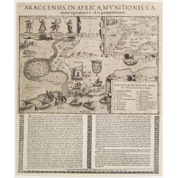
Araccensis in Africa, Munitionis catholico regi traditae..
Very rare so-called Einblatt druck of Morocco. In upper right hand corner inset map of Morocco and southern tip of Spain, Canaries and an over-sized Majorca. To the left ...
Date: Augsburg 1611
Selling price: ????
Please login to see price!
Sold
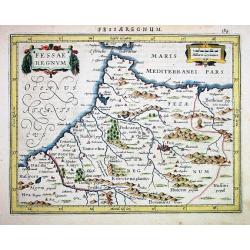
Fessae Regnum
Janssons desirable map of northern Morocco and Gibraltar, engraved for Mercators Atlas Minor. Very detailed with well engraved symbols representing towns, mountains, wood...
Date: Amsterdam 1628
Selling price: ????
Please login to see price!
Sold
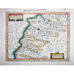
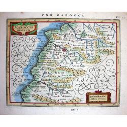
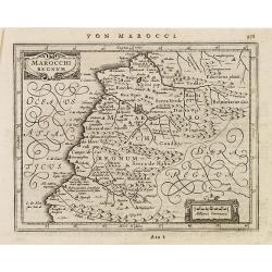
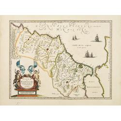
MAROCCHI REGNUM
Janssons desirable map of Morocco and the Atlas Mountains, engraved for Mercators Atlas Minor (page 579). Very detailed with well engraved symbols representing towns, mou...
Date: Amsterdam, 1628
Selling price: ????
Please login to see price!
Sold in 2008
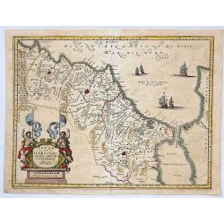
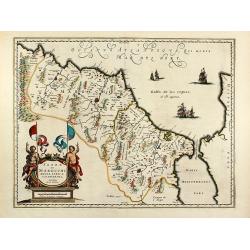
Marocchi Regnum.
Janssons beautiful map of Morocco and the Atlas Mountains, engraved for Mercators Atlas Minor (page 371-A22 2). Very detailed with a lot of topographical information and ...
Date: Amsterdam, 1628
Selling price: ????
Please login to see price!
Sold in 2008
Fessae et Marocchi Regna.
One of the new maps added by Hondius, when he took over publication of the Atlas, a finely engraved and decorative map of north-west Africa, with the Canaries. With an in...
Date: Amsterdam 1630
Selling price: ????
Please login to see price!
Sold
Fessae regnum.
Nice small map of the northeast tip of Africa with Fez showing as the principal city. Decorative title and distance scale cartouches. German text on verso.
Date: Amsterdam, c. 1630
Selling price: ????
Please login to see price!
Sold in 2010
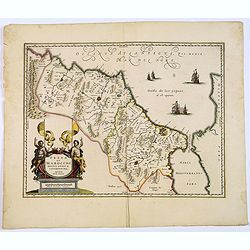
Marocchi Regnum.
A nice map of a part of Morocco with the city Marrakech.
Date: Amsterdam, c.1630
Selling price: ????
Please login to see price!
Sold in 2011
Fessae Regnum.
Charming small map of the northeast tip of Africa with Fez showing as the principal city. Decorative title and distance scale cartouches.
Date: Amsterdam, 1634
Selling price: ????
Please login to see price!
Sold in 2015
Fezzae et Marocchi regna Africae celeberrima.
An attractive map of northwest Africa and Morocco. The Pillars of Hercules & Straits of Gibraltar, and Spain are shown to the right of the map (north is to the right ...
Date: Amsterdam, 1638
Selling price: ????
Please login to see price!
Sold in 2018
Fezzae et Marocchi regna Africae celeberrima.
North to the right. A finely engraved, decorative map, who influenced subsequent maps for the rest of the century.As Willem Blaeu died in 1638 most of his maps are actual...
Date: Amsterdam, 1638
Selling price: ????
Please login to see price!
Sold in 2016
Fezzae et Marocchi regna Africae celeberrima.
North to the right. A finely engraved, decorative map, who influenced subsequent maps for the rest of the century.
Date: Amsterdam, 1638
Selling price: ????
Please login to see price!
Sold in 2009
Fezzae et Marocchi regna Africae celeberrima.
North to the right. A finely engraved, decorative map, who influenced subsequent maps for the rest of the century.
Date: Amsterdam 1638
Selling price: ????
Please login to see price!
Sold
Fezzae et Marocchi regna Africae celeberrima.
A finely engraved, decorative map of Fez and Morocco by Blaeu, who cartography greatly influenced subsequent maps for the rest of the century. North is orientated to the ...
Date: Amsterdam, 1638
Selling price: ????
Please login to see price!
Sold in 2017
Fezzae et Marocchi regna Africae celeberrima.
North to the right. Showing the Atlas Mountains in the south to the southern coast of Spain, along the coast at Ceuta, Tangiers, and Arzilla.A finely engraved, decorative...
Date: Amsterdam, 1638
Selling price: ????
Please login to see price!
Sold in 2015
Fezzae et Marocchi Regna Africae Celeberrima.
A fine and detailed map of Morocco showing the large fortified towns of Marakesh, Taradante and Fez. A large decorative cartouche depicts two Centaurs holding flags, and ...
Date: Amsterdam, 1638
Selling price: ????
Please login to see price!
Sold in 2019
Fezzae et Marocchi Regna Africae Celeberrima, describebat Arab. Ortelius.
A detailed map of Morocco, oriented with north on the right. Showss Morocco, the Kingdom of Fez, the Atlas Mountains, and the coast of Spain. The Strait of Gibraltar is a...
Date: Amsterdam, ca. 1640
Selling price: ????
Please login to see price!
Sold in 2019
Fezzae et Marocchi regna Africae celeberrima.
An attractive map of northwest Africa and Morocco. The Pillars of Hercules & Straits of Gibraltar, and Spain are shown to the right of the map (north is to the right ...
Date: Amsterdam, 1640
Selling price: ????
Please login to see price!
Sold
Fezzae et Marocchi regna Africae celeberrima
Old colored map of Morocco by W. Blaeu. With the Strait of Gibraltar, several sailing ships and a large figural cartouche. The map is based on Ortelius map of 1570. From ...
Date: Amsterdam, 1640
Selling price: ????
Please login to see price!
Sold in 2009
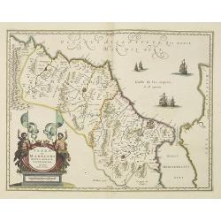
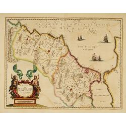
Marocchi Regnum.
Samuel Purchas' edition of the Mercator/Hondius "Atlas Minor". Early map of Morocco published in his famous collection of voyages "His Pilgrimes". Wit...
Date: London, 1645
Selling price: ????
Please login to see price!
Sold in 2020
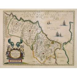
Fessae regnum.
The rare Samuel Purchas' edition of the Mercator/Hondius Atlas Minor atlas map. Early map of Morocco published in his famous collection of voyages His Pilgrimes . With de...
Date: London, 1645
Selling price: ????
Please login to see price!
Sold
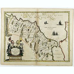
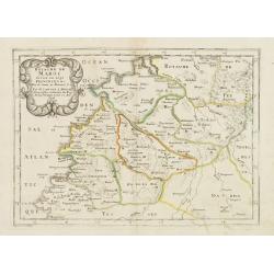
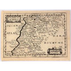
ROYAUME de MAROC divise en sept-Provinces &c.
A very fine, old color, decorative map of Morocco, first published by Nicholas Sanson in 1654. The map is based in part on the maps in the atlas of Livio Sanuto.
Date: Paris 1654
Selling price: ????
Please login to see price!
Sold in 2019
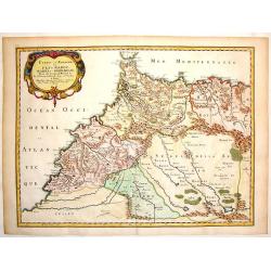
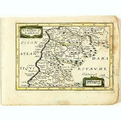
Estats et Royaumes de Fez et Maroc, Darha et Segelmesse.
A striking map of today's Morocco and Algeria that includes the southern tip of Spain and the Strait of Gibraltar. Decorated by a large title cartouche.Nicolas Sanson (16...
Date: Paris, 1655
Selling price: ????
Please login to see price!
Sold in 2014
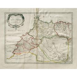
Estats et Royaumes de Fez et Maroc, Darha et Seglmesse.
A decorative map of Morocco with illustrated topography and many towns and villages. Beautifully engraved title cartouche. Extends into Algeria with good detail of rivers...
Date: Paris, 1655
Selling price: ????
Please login to see price!
Sold in 2019
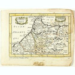
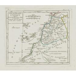
PARTIE DU BILEDULGERID ou sont TESSET, DARHA et SEGELMESSE &c.
A very fine decorative map of Morocco and the Canary Islands. In upper left hand corner decorative title cartouche. Engraved by A.de Winter.
Date: Paris 1657
Selling price: ????
Please login to see price!
Sold in 2019
Le Royaume de Fez. (11).
Scarce map of the kingdom of Fes in Morocco published by Antoine de Fer in 1661 or 1662 in "Cartes de géographie revues et augmentées". With Antoine de Fer's im...
Date: Paris, Antoine de Fer, 1657 but 1661 or 1662
Selling price: ????
Please login to see price!
Sold in 2020
Le Royaume de Maroc. (12).
Scarce map of Morocco published by Antoine de Fer in 1661 or 1662 in "Cartes de géographie revues et augmentées". With number 12 in lower right bottom of the ma...
Date: Paris, Antoine de Fer, 1657 but 1661 or 1662
Selling price: ????
Please login to see price!
Sold in 2020
Royaume de Maroc. . .
Map of Morocco prepared by N.Sanson and published by Pierre Mariette.Published in an early edition of the small Sanson atlas L'Europe Dediée a Monseigneur . . . Le Tellie...
Date: Paris, P. Mariette, 1667
Selling price: ????
Please login to see price!
Sold in 2012
Le Royaume de Marroc.
Rare map of Morocco published by Jollain in 1667. Published in "Trésor Des Cartes Geographiques Des Principaux Estats de Lunivers". This atlas is based upon Bo...
Date: Paris, 1667
Selling price: ????
Please login to see price!
Sold in 2016
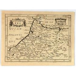
Le Royaume de Fez.
Rare map of a part of Morocco published by Jollain in 1667. Published in "Trésor Des Cartes Geographiques Des Principaux Estats de Lunivers". This atlas is bas...
Date: Paris, 1667
Selling price: ????
Please login to see price!
Sold in 2020
Fezzae et Marocchi Regna Africae Celeberrima.
A lovely example of John Ogilby's map of Fez and Morocco in north Africa, published in London during the second half of the 17th century. North is orientated to the left,...
Date: London, 1670
Selling price: ????
Please login to see price!
Sold in 2020
Fezzae et Marochi.
Decorative map of Morocco based on Blaeu's map of the same title. It is oriented with north on the right and includes the Strait of Gibraltar. The sea is filled with seve...
Date: Amsterdam, 1673
Selling price: ????
Please login to see price!
Sold in 2015
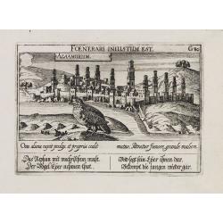
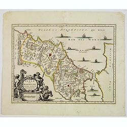
Azaamurum.
A very nice view of the town of Azemmour in Morocco. With a verse in two languages underneath the picture.The poet and topographer from Comothau, Daniel Meisner (1585-162...
Date: Frankfurt, 1623-1678
Selling price: ????
Please login to see price!
Sold in 2017
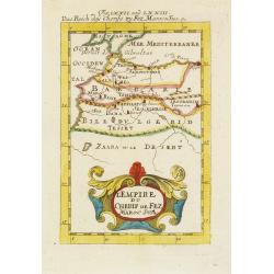
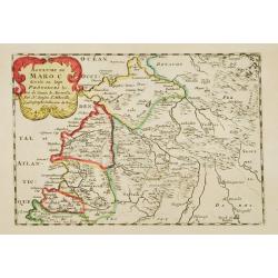
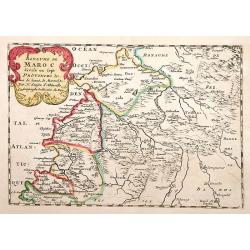
L'Empire du Cherif de Fez Maroc Sud & C. . .
A charming map of Morocco with colored coastlines and a beautiful colorful title cartouche.German title in curtain draped at top. No text on verso.From the German text ed...
Date: Frankfurt, 1684
Selling price: ????
Please login to see price!
Sold in 2008
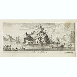
Penon de Velez.
Magnificent panoramic of Penon de Velez de la Gomera, a Spanish rock in North Africa off the Moroccan coast (Plazas de soberanía). Etched by Gaspar Bouttats (1640-1695)....
Date: Antwerp, c.1690
Selling price: ????
Please login to see price!
Sold in 2017
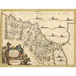
FEZZAE et MAROCCHI Regna Africae Celeberrima.
A beautiful, old color map of Morocco, showing large fortified towns of Marakesh, Taradante and Fez, towns, mountains, rivers, lakes, etc. Tanger, Cueta and Rio Rabata al...
Date: Amsterdam, 1700
Selling price: ????
Please login to see price!
Sold in 2021

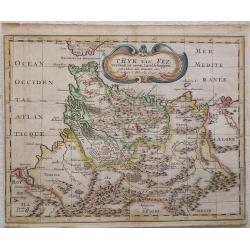
T Ryk van Fez verdeelt in zeven Landschappen
Nicolas Sanson (1600-67), ' father of the French cartography' and founder of the Sanson firm. Atlas ' Cartes générales de toutes les parties du Monde', 1658-70 and a pock...
Date: Amsterdam, F. Halma, 1705
Selling price: ????
Please login to see price!
Sold in 2018
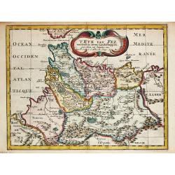
T Ryk van Fez verdeelt in zeven Landschappen, getrokken uit Sanutus enz.
Map of Fez in Morocco. Published by Frans Halma
Date: Utrecht, F. Halma,1705
Selling price: ????
Please login to see price!
Sold in 2013
' T Ryk van Fez verdeelt in zeven Landschappen
Nicolas Sanson (1600-67), ' father of the French cartography' and founder of the Sanson firm. Atlas ' Cartes générales de toutes les parties du Monde', 1658-70 and a pock...
Date: Amsterdam, F. Halma, 1705
Selling price: ????
Please login to see price!
Sold in 2009
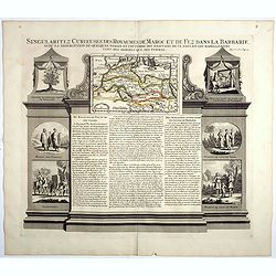
Singularitez Curieuses des Royaumes de Maroc et de Fez dans la Barbarie . . .
In the top a map of the Barbary Coast entitled La Barbarie. The text in the center of the sheet describes the Kingdoms of Morocco and Fez. The panel is bordered with thei...
Date: Amsterdam, 1720
Selling price: ????
Please login to see price!
Sold in 2023
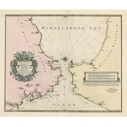
Nieuwe Paskaart vant Naauw van de Straat. op gedragen aan den Hoog Edel geboren Heer F. Van Aerssen Van Sommelsduk
This is a scarce and well designed sea chart of the Strait of Gibraltar, oriented east with Spain on the left and the Barbary Coast (present-day Morocco) on the right. Th...
Date: Amsterdam 1726
Selling price: ????
Please login to see price!
Sold in 2023
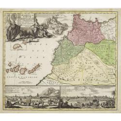
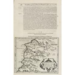
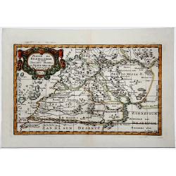
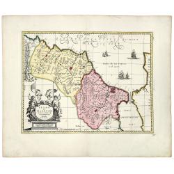
Statuum Marocca Norum.
Large and very graphic map by the prominent German cartographer. The map itself is very detailed showing the domains of desert tribes by means of little tent cities. It e...
Date: Nuremberg, 1728
Selling price: ????
Please login to see price!
Sold
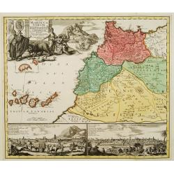
Statuum Marocca Norum.
Large and very graphic map by the preeminent German cartographer. The map itself is very detailed showing the domains of desert tribes by means of little tent cities. It ...
Date: Nuremberg 1728
Selling price: ????
Please login to see price!
Sold
![Statuum MAROCCANORUM. Regnorum nempe Fessanim Maroccani, Tafiletani et Segelomessani... [Canary islands]](/uploads/cache/83546-250x250.jpg)
Statuum MAROCCANORUM. Regnorum nempe Fessanim Maroccani, Tafiletani et Segelomessani... [Canary islands]
Scarce map of Morocco, with two city views below. Includes a striking allegorical cartouche and inset map of Madeira,and the Canary islands.
Date: Nuremberg, 1728
Selling price: ????
Please login to see price!
Sold in 2020
Royaume de Maroc divise en sept Provinces..
Attractive map of Morocco prepared by Daniel de La Feuille (1702) and published in the rare first edition of ,Kleyne en Beknopte Atlas, of Tooneel des Oorlogs in Europa.....
Date: Amsterdam 1735
Selling price: ????
Please login to see price!
Sold
Royaume de Maroc divise en sept Provinces..
Attractive map of Morocco prepared by Daniel de La Feuille (1702) and published in the rare first edition of "Kleyne en Beknopte Atlas, of Tooneel des Oorlogs in Eur...
Date: Amsterdam 1735
Selling price: ????
Please login to see price!
Sold
Cote Occidentale d'Afrique.. Canaries.
Nice small map illustrating the African shores of Morocco and Western Sahara. The Canary Islands and the Madeira Islands are also shown.From Atlas Portatif Universel, by ...
Date: Paris, later than 1748
Selling price: ????
Please login to see price!
Sold in 2017
![[75] Barbarie.. Mamora.. Salee](/uploads/cache/12905-250x250.jpg)
[75] Barbarie.. Mamora.. Salee
"Charming chart of including the harbours of Mamora, Salee, etc. Showing town and harbour plan, with soundings, anchorages, rocks, shoals, fortifications and lightho...
Date: Marseille 1764
Selling price: ????
Please login to see price!
Sold in 2014
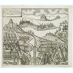
Auss Schiff und Anländung der Spanischen Völcker bey Ceuta in Africa. . .
Very rare and decorative but fanciful copper engraved view of the Siege of Ceuta by the Moroccan Sultan in 1418. The Sultan was defeated and the town stayed in Spanish / ...
Date: Zittau, 1798-1800
Selling price: ????
Please login to see price!
Sold in 2020
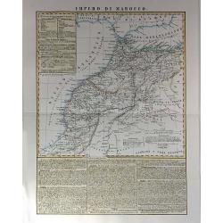
Impero di Marocco
Very attractive and scarce map of Morocco by Benedetto Marzolla, a cartographer from Naples. Marzolla prints extensive notes with his maps, listing his cartographic sourc...
Date: Naples, 1848
Selling price: ????
Please login to see price!
Sold in 2017
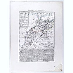
Impero di Marocco.
An interesting and uncommon detailed and large-scale Italian map of Morocco. The Italian text below provides historical, political and commercial information. Published i...
Date: Naples, 1856
Selling price: ????
Please login to see price!
Sold in 2021
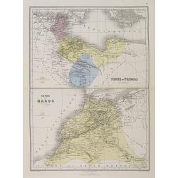
Empire de Maroc. / Tunis et Tripoli.
A decorative map of Morocco, with Tunis and Tripoli from Géographie Universelle, Atlas Migeon, published by J. Migeon.< br />From one of the last decorative atlases...
Date: Paris, 1874
Selling price: ????
Please login to see price!
Sold
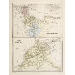
Tunis et Tripoli .. / Empire de Maroc. Par A.T.Chartier.
Decorative map of the cities of Tunis and Tripoli as well as the Maroc from Géographie Universelle, Atlas Migeon. published by J. Migeon. From one of the last decorative ...
Date: Paris, 1874
Selling price: ????
Please login to see price!
Sold in 2015
![Marocco [Morocco]](/uploads/cache/1152967-250x250.jpg)
Marocco [Morocco]
Original hand-colored double page map (39 x 53 cm, overall dimensions 50 x 64 cm.).
Date: London: James Wyld. Geographer to the Queen, 1880
Selling price: ????
Please login to see price!
Sold in 2020
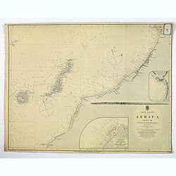
West Coast of Africa, Sheet III Sta. Cruz to Cape Bojador.
A large sea chart of an area of the north-western African coast from Santa Cruz to Cape Bojador, first surveyed in 1835 by Lieut. Arlett, R.N. The chart features depth so...
Date: London, ca 1890
Selling price: ????
Please login to see price!
Sold in 2019
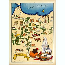
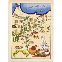
Maroc.
Very decorative, informative map of Morocco. The map is filled with buildings, animals, a ship, figures and three locals in their typical dress.In lower left corner "...
Date: France, 1943
Selling price: ????
Please login to see price!
Sold in 2016
Maroc.
Very decorative, informative map of Marocco. The map is filled with buildings, animals, a ship, figures and three locals in their typical dress.In lower left corner "...
Date: France, 1943
Selling price: ????
Please login to see price!
Sold in 2010
