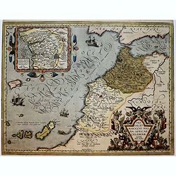
Browse Listings in Africa > North Africa
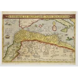
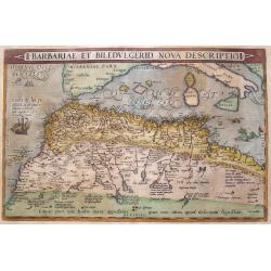
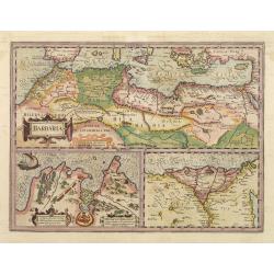
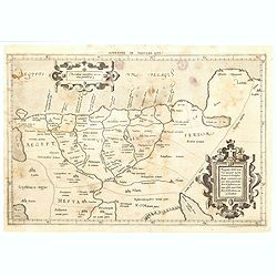
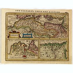
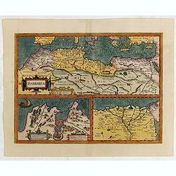
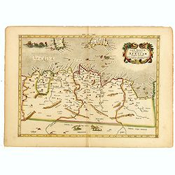
Barbariae et Biledulgerid, nova descriptio.
North-West Africa. Koeman speculated: In view of the important trading relationship between Antwerp and Africa, it is not impossible that the original was a manuscript ma...
Date: Antwerp 1587
Selling price: ????
Please login to see price!
Sold
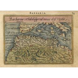
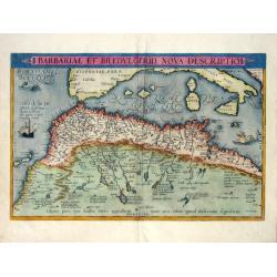
Barbariae et biledulgerid nova descriptio
Miniature map of the Barbary coast and parts of Italy and Spain. The map is beautifully engraved with stippled seas.
Date: Antwerp, 1588
Selling price: ????
Please login to see price!
Sold
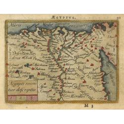
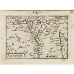
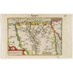
Aegiipti recentior descriptio
Miniature map showing the Nile valley in great detail with numerous place names. The map is beautifully engraved with stippled seas.
Date: Antwerp, 1588
Selling price: ????
Please login to see price!
Sold
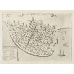
![Cairus, quae olim Babylon, . . . [Cairo]](/uploads/cache/60659-250x250.jpg)
Cairus, quae olim Babylon, . . . [Cairo]
Contemporaneous bird's-eye and surroundings showing the Pyramids and the Sphinx. Egypt had fallen to the Turks during the reign of Selim I at the beginning of the 16th c...
Date: Cologne, 1590
Selling price: ????
Please login to see price!
Sold
![Nova Africa hoc est,recens eius inuestigatio. [North Africa]](/uploads/cache/32529-250x250.jpg)
Nova Africa hoc est,recens eius inuestigatio. [North Africa]
On verso an early map of North West Africa (123x155mm.), with on recto a small map of the island of Madeira (120x78mm.) From a Latin text edition of his Geographia , that...
Date: Basle, 1550-1590
Selling price: ????
Please login to see price!
Sold in 2013
![De Cyrene seu Cyrenaica. [Egypt and Ethiopia]](/uploads/cache/32582-250x250.jpg)
De Cyrene seu Cyrenaica. [Egypt and Ethiopia]
On recto an early wood block printed map of Egypt and Ethiopia and the Arabian Peninsular tio the right. (160xFrom a Latin text edition of his Geographia, that great comp...
Date: Basle, 1550-1590
Selling price: ????
Please login to see price!
Sold in 2014
![[Egypte]](/uploads/cache/32584-250x250.jpg)
[Egypte]
On recto an early wood block printed map of Northern Egypt (176x160mm.) .From a Latin text edition of his Geographia , that great compendium of Renaissance knowledge.
Date: Basle, 1550-1590
Selling price: ????
Please login to see price!
Sold in 2013
![Pyramides Aegypti. [Pyramides in Egypt]](/uploads/cache/32590-250x250.jpg)
Pyramides Aegypti. [Pyramides in Egypt]
On verso a wood block printed depiction of three pyramids in Egypt.From a Latin text edition of his Geographia , that great compendium of Renaissance knowledge.
Date: Basle, 1550-1590
Selling price: ????
Please login to see price!
Sold in 2013
![[De Africae regionibus / Carthage]](/uploads/cache/32593-250x250.jpg)
[De Africae regionibus / Carthage]
On the verso an early birds-eye view of Tunis, which was the original city of Carthage (240x168mm.). The plan includes zoological and botanical gardens, castle Goleta, a ...
Date: Basle, 1550-1590
Selling price: ????
Please login to see price!
Sold in 2013
![[De Africae regionibus ] Algier.](/uploads/cache/32594-250x250.jpg)
[De Africae regionibus ] Algier.
On verso an early birds-eye town-plan of Alger.From a Latin text edition of his Geographia , that great compendium of Renaissance knowledge.
Date: Basle, 1550-1590
Selling price: ????
Please login to see price!
Sold in 2013
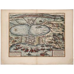
TUNES URBS ac Novae Eius Arcis et Guletae. Quae Philippo Hispan . . .
A striking old color example of Braun & Hogenberg's important early town view of Tunis. Text on verso. The image shows a siege of the port by Spanish ships under the ...
Date: Cologne, 1590
Selling price: ????
Please login to see price!
Sold in 2019
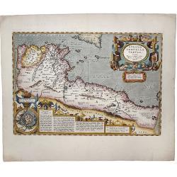
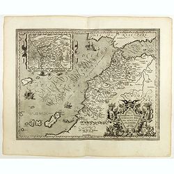
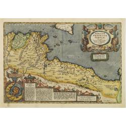
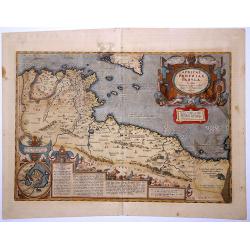
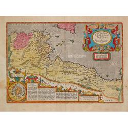
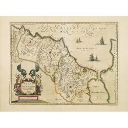
Africae propriae tabula. In qua, Punica regna uides; Tyrios, et Agenoris urbem.
The most beautiful early map of the northern coast of Africa available to the collector. Prepared by Ortelius himself. A very fine example. Ortelius based this map on tha...
Date: Antwerp,1590
Selling price: ????
Please login to see price!
Sold in 2020
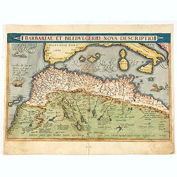
Barbariae Et Biledvlgerid, Nova Descriptio.
Attractive map of Africa by Abraham Ortelius. The map covers the area on the north-west coast of Africa from about present day Senegal and "Fume del Oro"...
Date: Antwerp, (1570) 1592
Selling price: ????
Please login to see price!
Sold in 2011
Barbariae Et Biledvlgerid...
Remarkable map of Northern Africa in an early shape. Extends from Morocco and the Sahara to Libya and large parts of the Mediterranean, including the Balearic Islands, Si...
Date: Antwerp, 1592
Selling price: ????
Please login to see price!
Sold in 2016
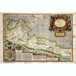
Africae propriae Tabula..
The most beautiful early map of the northern coast of Africa that is available to the collector. Prepared by Ortelius himself based on modern information from Gastaldi's ...
Date: Antwerp 1595
Selling price: ????
Please login to see price!
Sold
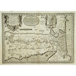
Aegyptus Antiqua.
A splendid map of ancient Egypt, which appeared in Ortelius' Parergon. The map is based on his separately published map of Egypt, published in 1565, but with differences ...
Date: Antwerp 1595
Selling price: ????
Please login to see price!
Sold
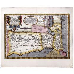
AEGYPTUS ANTIQUA. Terra suis contante bonis, non indiga mercis. . .
A splendid map of ancient Egypt, which appeared in Ortelius' Parergon. The map is based on his separately published map of Egypt, published in 1565, but with differences ...
Date: Antwerp, 1595
Selling price: ????
Please login to see price!
Sold in 2020
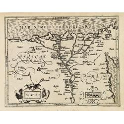
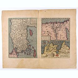
![[Lot of 9 maps/ prints of Egypt ] Aegypti Recentior Descriptio / Carthaginis Celeberrimi Sinus Typus.](/uploads/cache/18309-(8)-250x250.jpg)
[Lot of 9 maps/ prints of Egypt ] Aegypti Recentior Descriptio / Carthaginis Celeberrimi Sinus Typus.
Abraham Ortelius' maps of Egypt and Carthago on one sheet.Abraham Ortelius(1527-98), Dutch cartographer and publisher of the first modern atlas, ' Theatrum Orbis Terrarum...
Date: Antwerp, 1595
Selling price: ????
Please login to see price!
Sold in 2023
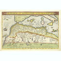
Barbariae et Biledulgerid, nova descriptio.
North-West Africa. Koeman speculated: In view of the important trading relationship between Antwerp and Africa, it is not impossible that the original was a manuscript ma...
Date: Amsterdam, 1596
Selling price: ????
Please login to see price!
Sold

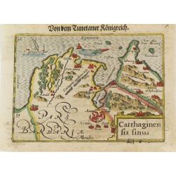
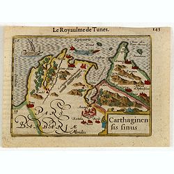
Carthaginensis sinus.
Very fine early miniature map showing Tunis and its surroundings. The sea is embellished with a ship and a sea monster. The map depicts the ancient site of Carthage with ...
Date: Middelburg, 1598
Selling price: ????
Please login to see price!
Sold in 2014
Aegyptus.
Very fine early miniature map of Egypt, showing the Nile delta . Title cartouche on the lower left corner. Scarce miniature map from the second series of miniature atlas ...
Date: Antwerp, 1598
Selling price: ????
Please login to see price!
Sold in 2015
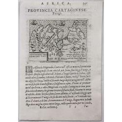
Provincia Cartaginese. Tunigi.
An attractive small map of the environs of Tunis in Northern Africa. It is from the "Relationi Universale" by Botero, published in Venice in 1598. Woodcut in pa...
Date: Venice, 1598
Selling price: ????
Please login to see price!
Sold in 2017
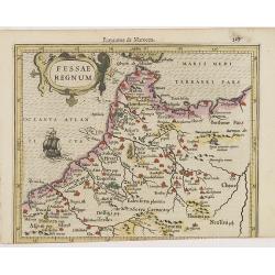
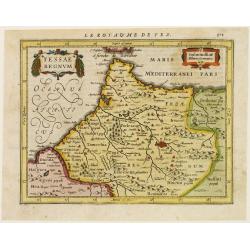
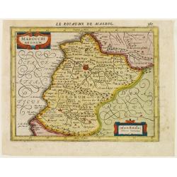
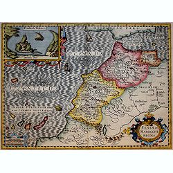
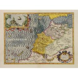
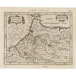
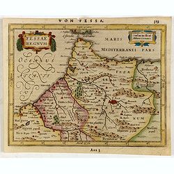
Fessae et Marocchi regna Africae celeberr.
Uncommon map, covering north-western Africa, with the Canaries and Madeira. With an inset of the Congo, after Filippo Pigafetta's famous map of the kingdom. Dare to go...
Date: Antwerp, 1598
Selling price: ????
Please login to see price!
Sold in 2020
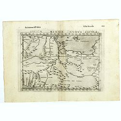
Africa minor nuova tavola.
The third state of Ruscelli's map of North Africa, based upon Claudius Ptolemy. Showing the region of present day Algiers, Tunisia and Libya. Girolamo Ruscelli first publ...
Date: Venice, 1598
Selling price: ????
Please login to see price!
Sold in 2018
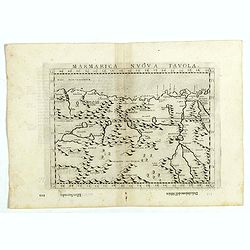
Marmarica nuova tavola.
The third state of Ruscelli's map of northern Africa based upon Claudius Ptolemy. Showing the Nubia Desert and showing Egypt, the Nile, etc. Girolamo Ruscelli first publi...
Date: Venice, 1598
Selling price: ????
Please login to see price!
Sold in 2018
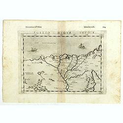
Egito vuova tavola.
The third state of Ruscelli's map of Egypt with the river Nile, based upon Claudius Ptolemy. Showing Egypt and the Nile. Extends east to the Upper Red Sea and West to Des...
Date: Venice, 1598
Selling price: ????
Please login to see price!
Sold in 2018
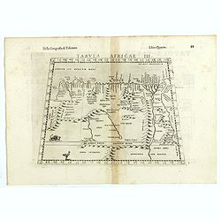
Tabula Africae III.
The third state of Ruscelli's map of North Africa and the Mediterranean, based upon Claudius Ptolemy. Showing the north coast of Africa including Egypt and the Nile River...
Date: Venice, 1598
Selling price: ????
Please login to see price!
Sold in 2018
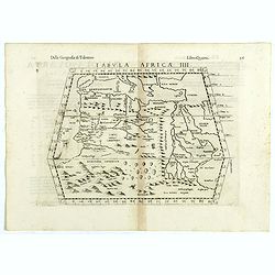
Tabula Africae IIII.
The third state of Ruscelli's map of The Northern part of Africa, based upon Claudius Ptolemy. Showing Mediterranean, Aethiopia Interior, the Canary Islands, Asia Minor, ...
Date: Venice, 1598
Selling price: ????
Please login to see price!
Sold in 2018
Barbariae et Biledulgerid, nova descriptio.
North-West Africa. Koeman speculated: In view of the important trading relationship between Antwerp and Africa, it is not impossible that the original was a manuscript ma...
Date: Antwerp, 1598
Selling price: ????
Please login to see price!
Sold in 2021
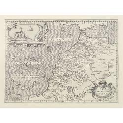
Fessae, et Marocchi Regna Africae Celeberr. describebat Abrah. Ortelius. 1595.
Uncommon map, covering north-western Africa, with the Canaries and Madeira. With an inset of the Congo, after Filippo Pigafetta's famous map of the kingdom.
Date: Antwerp, 1602
Selling price: ????
Please login to see price!
Sold in 2017
Africae propriae Tabula..
The most beautiful early map of the northern coast of Africa available to the collector. Prepared by Ortelius himself. Ortelius based the map on Gastaldi.
Date: Antwerp 1603
Selling price: ????
Please login to see price!
Sold
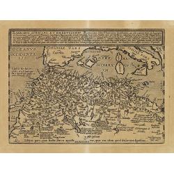
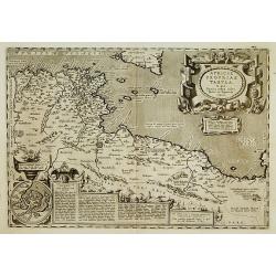
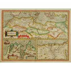
Barbaria Africana, et Biledulgerid. . .
Uncommon map showing the south of Spain, and the northwest of Africa, with Morocco, Algeria, Tunisia. With the Canary Islands in the outer left.
Date: Cologne, Bussemacher, 1603
Selling price: ????
Please login to see price!
Sold in 2011
Africae propriae Tabula..
The most beautiful early map of the northern coast of Africa available to the collector. Prepared by Ortelius himself. Ortelius based the map on Gastaldi.
Date: Antwerp, 1603
Selling price: ????
Please login to see price!
Sold in 2018
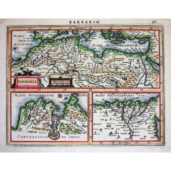
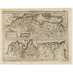
Barbaria/ Egypt/ Tunesia.
Upper map showing the Northern African coast, including Cyprus, Greece and Sicily. Lower part maps of Tunis and Nile Delta.
Date: Amsterdam, 1606
Selling price: ????
Please login to see price!
Sold
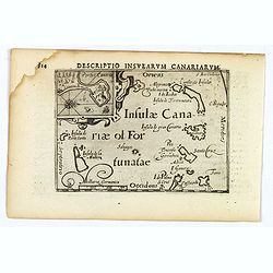
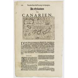
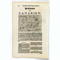
Descriptio Insularum Canariarum.
A beautiful miniature map by Bertius shows the Canary islands with Palma, Gomera, Ferro, Tenerifa, Gran Canaria, Forte Ventura and Lanzerote. Decorative, ornamental title...
Date: Amsterdam, 1606
Selling price: ????
Please login to see price!
Sold in 2019
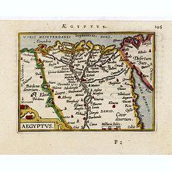
Aegyptus.
Map showing Egypt, centered on the Nile delta. Including cities of Alexandria, Cairo, Suez, etc.
Date: Amsterdam, 1607
Selling price: ????
Please login to see price!
Sold in 2011
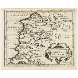
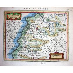
Marocchi regnum.
Miniature map showing Morocco. Decorated with two strap work cartouches. Mountains, cities and forests fill the land. The capital city of Marruecos (Marrakech) in the cen...
Date: Amsterdam 1607
Selling price: ????
Please login to see price!
Sold in 2011
Barbaria.
Upper map showing the Northern African coast, including Cyprus, Greece and Sicily. Lower part maps of Tunis and Nile Delta.From the first French-text edition of Jodocus H...
Date: Amsterdam, 1608
Selling price: ????
Please login to see price!
Sold in 2011
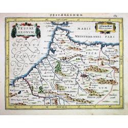
Fessae Regnum.
Charming small map of the northeast tip of Africa with Fez showing as the principal city. Decorative title cartouche.From the first French-text edition of Jodocus Hondius...
Date: Amsterdam, 1608
Selling price: ????
Please login to see price!
Sold in 2011
AFRICAE PROPRIAE TABULA. In qua, Punica regna uides; Tyrios, et Agenoris urbem.
The most beautiful early map of the northern coast of Africa available to the collector. Prepared by Ortelius himself. This fine example is from the rare Italian edition ...
Date: Antwerp, 1608
Selling price: ????
Please login to see price!
Sold in 2021
Aegyptus.
Very fine early miniature map of Egypt, showing the Nile delta . Title cartouche on the lower left corner. First published in 1598 in his Caert-Thresoor, the plates were ...
Date: Amsterdam/Frankfurt, 1609
Selling price: ????
Please login to see price!
Sold in 2010
AFRICAE / PROPRIAE / TABULA / In qua, / Punica regna vides. / Tyrios, et Agenoris / urbem. / 1590.
A very decorative map of Northern Africa. Abraham Ortelius(1527-98), Dutch cartographer and publisher of the first modern atlas, ' Theatrum Orbis Terrarum' in 1570. Editi...
Date: Antwerp, Robert Bruneau, 1609
Selling price: ????
Please login to see price!
Sold in 2021
Aegyptus.
Very fine early miniature map of Egypt, showing the Nile delta . Title cartouche on the lower left corner. First published in 1598 in his Caert-Thresoor, the plates were ...
Date: Frankfurt, 1609
Selling price: ????
Please login to see price!
Sold in 2011
Carthaginensis Sinus.
Early miniature map of Tunisian northern coast. Title cartouche on the lower right corner. First published in 1598 in his Caert-Thresoor, the plates were executed by the ...
Date: Amsterdam/Frankfurt 1609
Selling price: ????
Please login to see price!
Sold in 2008
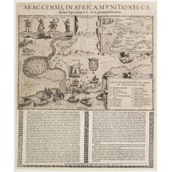
Araccensis in Africa, Munitionis catholico regi traditae..
Very rare so-called Einblatt druck of Morocco. In upper right hand corner inset map of Morocco and southern tip of Spain, Canaries and an over-sized Majorca. To the left ...
Date: Augsburg 1611
Selling price: ????
Please login to see price!
Sold
Carthaginen fis Finus.
This is a map of the Barbary area, subtitled "Le royaulme des Tunes".
Date: Amsterdam, 1612
Selling price: ????
Please login to see price!
Sold in 2015
Natoliae. . .Aegypti recentior..Carthaginis (3 maps on 1 sheet).
Rare. Three maps on one sheet. Map to the left east to the top. Detailed map Turkey, including Cyprus and Crete. Also map of the Nile delta and another map of Tunis.
Date: Antwerp, 1608-1612
Selling price: ????
Please login to see price!
Sold in 2020
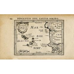
Insulae Capitis Viridis
Attractive map of the Cape Verde islands and the Moroccan coast. Very detailed naming many cities, islands, and major rivers. Decorative map from a Hondius/Bertius pocket...
Date: Amsterdam c. 1616
Selling price: ????
Please login to see price!
Sold in 2009
Fessae regnum.
Nice small map of the northeast tip of Africa with Fez showing as the principal city. Decorative title and distance scale cartouches. French text on verso.
Date: Amsterdam 1617
Selling price: ????
Please login to see price!
Sold
Marocchi Regnum.
A nice map of a part of Morocco with the city Marrakech.
Date: Amsterdam 1617
Selling price: ????
Please login to see price!
Sold
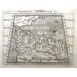
Tabula Aphricae I.
A fine Ptolemaic map, probably from the Jansson/Magini atlas of 1617. It shows parts of today's Morocco and Algeria. Includes also a part of southern Spain and the Balear...
Date: Amsterdam, 1617
Selling price: ????
Please login to see price!
Sold in 2018
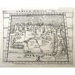
Tabula Africae III.
An interesting Ptolemaic map, probably from the Jansson/Magini atlas of 1617. It illustrates early Lybia and Egypt. With the Nile River and the Red Sea. Latin text on ver...
Date: Amsterdam, 1617
Selling price: ????
Please login to see price!
Sold in 2018
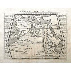
Tabula Africae IIII.
A fine Ptolemaic map, probably from the Jansson/Magini atlas of 1617. It shows southern Europe, northern Africa, including Arabia in an early representation with curious ...
Date: Amsterdam, 1617
Selling price: ????
Please login to see price!
Sold in 2018
Appendix Tab. III. Africae, Aegyptum Inferiorem Exhibens.
Map of the Nile delta based on the Ptolemaic model. Mercator originally published this map in his 1578 edition of Ptolemy's great Geography. Although he is most renowned ...
Date: Amsterdam, 1618
Selling price: ????
Please login to see price!
Sold in 2020
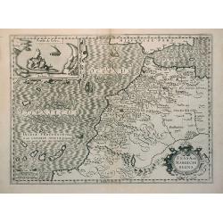
Fessae et Marocchi Regna
Richly embellished map of Morocco with a large inset titled Penon de Velez showing a fort on the Barbary coast. The map includes the Canary islands and Madera.Three strap...
Date: Amsterdam, 1619
Selling price: ????
Please login to see price!
Sold in 2017
![[View of Alexandria - The dream of Skanderbeg's mother]](/uploads/cache/49039-250x250.jpg)
[View of Alexandria - The dream of Skanderbeg's mother]
A view of Alexandria and on verso the dream of Skanderbeg's mother; the mother lying asleep on a bed, on a wall at the back set in clouds an illustration of her dream wit...
Date: Augsburg, 1533 - Frankfurt, 1620
Selling price: ????
Please login to see price!
Sold in 2025
Canariae I.
Small map of the Canary Islands, surrounded by text in Dutch. Nicolaes de Clerck (de Klerc) was active as engraver and publisher in Delft from 1599-1621.Included in the r...
Date: Amsterdam, Cloppenburch, 1621
Selling price: ????
Please login to see price!
Sold
Barbaria.
Small map illustrating the eastern part of the Mediterranean Basin, namely the African side. Surrounded by text in Dutch.Included in the rare book : Wereld Spiegel, waer ...
Date: Amsterdam, Cloppenburch, 1621
Selling price: ????
Please login to see price!
Sold in 2013
Canariae I.
Small map of the Canary Islands, surrounded by text in Dutch. Nicolaes de Clerck (de Klerc) was active as engraver and publisher in Delft from 1599-1621.Included in the r...
Date: Amsterdam, Cloppenburch, 1621
Selling price: ????
Please login to see price!
Sold in 2016
![[Egypt]](/uploads/cache/26451-250x250.jpg)
[Egypt]
Map of Egypt. From an uncommon edition of Kerckelycke Historie van Neder-Landt which was a Dutch text edition of Agostino Torniello's Annales Sacri et Profani by Heribert...
Date: Holland, ca. 1625
Selling price: ????
Please login to see price!
Sold in 2008
BARBARIA.
With two insets: Map of the Siege of Tunis and map of the Nile Delta.From the tenth edition of the Mercator's Atlas Sive Cosmographicae completed and reissued by Henricus...
Date: Amsterdam 1628
Selling price: ????
Please login to see price!
Sold
Fessae Regnum
Janssons desirable map of northern Morocco and Gibraltar, engraved for Mercators Atlas Minor. Very detailed with well engraved symbols representing towns, mountains, wood...
Date: Amsterdam 1628
Selling price: ????
Please login to see price!
Sold
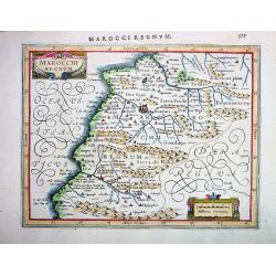
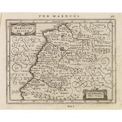
MAROCCHI REGNUM
Janssons desirable map of Morocco and the Atlas Mountains, engraved for Mercators Atlas Minor (page 579). Very detailed with well engraved symbols representing towns, mou...
Date: Amsterdam, 1628
Selling price: ????
Please login to see price!
Sold in 2008
Marocchi Regnum.
Janssons beautiful map of Morocco and the Atlas Mountains, engraved for Mercators Atlas Minor (page 371-A22 2). Very detailed with a lot of topographical information and ...
Date: Amsterdam, 1628
Selling price: ????
Please login to see price!
Sold in 2008
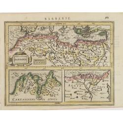
Barbaria.
Excellent map by Jansson, engraved for Mercators Atlas Minor (page 575). The map is divided in three parts: the top part is showing Northern Africa with the Mediterranean...
Date: Amsterdam, c.1628
Selling price: ????
Please login to see price!
Sold
Barbaria. / Carthaginensis sinus / Aegyptus.
With two insets: Map of the Siege of Tunis and map of the Nile Delta.From the tenth edition of the Mercator's Atlas Sive Cosmographicae completed and reissued by Henricus...
Date: Amsterdam, ca.1628
Selling price: ????
Please login to see price!
Sold in 2015
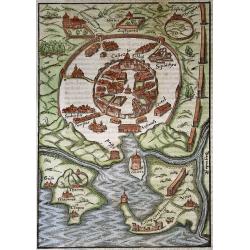
Tunis
Woodcut of the Barbary town Tunis and outside the double walls a Women house (Harem) Botanical Garden (Hortus) an ancient Thermae (Therme). As well as the ruins of Cartha...
Date: Basel, 1628
Selling price: ????
Please login to see price!
Sold in 2020
Civitas Acon sive Ptolomaida.
Rare town-plan of Acre, based upon the Vesconte-Sanuto plan, intended to illustrate a period when the town was under the control of the Knights of St. John. Shows extensi...
Date: Paris, Michael Soly, 1629
Selling price: ????
Please login to see price!
Sold in 2013
Fessae et Marocchi Regna.
One of the new maps added by Hondius, when he took over publication of the Atlas, a finely engraved and decorative map of north-west Africa, with the Canaries. With an in...
Date: Amsterdam 1630
Selling price: ????
Please login to see price!
Sold
Fessae et Marocchi Regna
Richly embellished map of Morocco with a large inset titled Penon de Velez showing a fort on the Barbary coast. The map includes the Canary islands and Madera.Three strap...
Date: Amsterdam, 1630
Selling price: ????
Please login to see price!
Sold
Fessae et Marocchi Regna.
Richly embellished map of Morocco with a large inset titled Penon de Velez showing a fort on the Barbary coast. The map includes the Canary islands and Madera.Three strap...
Date: Amsterdam, 1630
Selling price: ????
Please login to see price!
Sold in 2010
Fessae regnum.
Nice small map of the northeast tip of Africa with Fez showing as the principal city. Decorative title and distance scale cartouches. German text on verso.
Date: Amsterdam, c. 1630
Selling price: ????
Please login to see price!
Sold in 2010
Barbaria
Three maps on one sheet. In upper half a map of North Africa with the Mediterranean and Cyprus. In lower part maps of the region around Tunis and map of the Nile Delta.Fr...
Date: Amsterdam, c. 1630
Selling price: ????
Please login to see price!
Sold in 2011
Marocchi Regnum.
A nice map of a part of Morocco with the city Marrakech.
Date: Amsterdam, c.1630
Selling price: ????
Please login to see price!
Sold in 2011
Barbaria.
Charming map of the whole of North Africa and the famed Barbary coast. Two large insets at bottom: Carthaginensis Sinus with the city of Tunis, and a map of the Nile Delt...
Date: Amsterdam, 1630
Selling price: ????
Please login to see price!
Sold in 2015
Tab.II AFRICAE, Complectens AFRICAM Proprie dictam..
Decorative Ptolemaic map of Northern Africa with the southern part of Sardinia and Sicily and Malta. The sea is stipple engraved and contains two very fanciful sea monste...
Date: Amsterdam, 1630
Selling price: ????
Please login to see price!
Sold in 2015
![[Attack of Dutch fleet commanded by Pieter van der Does of Gran Canaria in 1599].](/uploads/cache/40179-250x250.jpg)
[Attack of Dutch fleet commanded by Pieter van der Does of Gran Canaria in 1599].
Attack of Dutch fleet commanded by Pieter van der Does of Gran Canaria in 1599. Scarce print (150x177mm.) on a German text sheet taken from a first edition of Johann Ludw...
Date: Frankfurt, M.Merian, 1633
Selling price: ????
Please login to see price!
Sold in 2025
![[Dutch fleet attacking Spanish fortess of Gratiosa on Gran Canaria].](/uploads/cache/39914-250x250.jpg)
[Dutch fleet attacking Spanish fortess of Gratiosa on Gran Canaria].
Scarce print with a German text sheet showing a fierce battle taking place between Spanish and Dutch forces. From de Bry's "Great American Voyages". Johann Theo...
Date: Frankfurt, M.Merian, 1633
Selling price: ????
Please login to see price!
Sold in 2018
Fessae Regnum.
Charming small map of the northeast tip of Africa with Fez showing as the principal city. Decorative title and distance scale cartouches.
Date: Amsterdam, 1634
Selling price: ????
Please login to see price!
Sold in 2015
Fezzae et Marocchi regna Africae celeberrima.
North to the right. A finely engraved, decorative map, who influenced subsequent maps for the rest of the century.
Date: Amsterdam 1638
Selling price: ????
Please login to see price!
Sold
