Recently Listed Listings
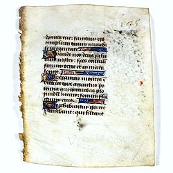
Leaf on vellum from a manuscript Book of Hours.
14 Lines of text in Latin and three 1-line initials in blue on colored grounds.RECTO: 14 Lines of text in Latin and three 1-line initials in blue on colored grounds with ...
Date: France, ca.1470
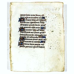
Leaf on vellum from a manuscript Book of Hours.
14 Lines of text in Latin and three 1-line initials in blue on colored grounds.RECTO: 14 Lines of text in Latin and four 1-line initials in blue on colored grounds with l...
Date: France, ca.1470
Selling price: ????
Please login to see price!
Sold in 2025

Carte des Iles Hawaii.
A lovely small map of the complete chain of Pacific islands known today as the Hawaiian islands, from Dumont d'Urville's atlas "Voyage pittoresque autour du Monde.&q...
Date: Paris, 1834

Americae Pars Magis Cognita. Chorographia nobilis & opulentae Peruanae Provinciae, atque Brasiliae, . . . MDXCII
First state. Although a map of South America it does include much of what is now the southern United States. There are two elaborate, strap-work cartouches with the one a...
Date: Frankfurt, 1592
![Tabula electoratus Brandenburgici, Meckelenburgi, et maximae partis Pomeraniae, ex variis, famosissimisq[ue] auctoribus summo studio concinnata. . .](/uploads/cache/37545-250x250.jpg)
Tabula electoratus Brandenburgici, Meckelenburgi, et maximae partis Pomeraniae, ex variis, famosissimisq[ue] auctoribus summo studio concinnata. . .
Uncommon "carte à figures"- map engraved by the master engraver Abraham Goos and published by Claes Jansz. Visscher (1587-1652). The map shows the part of west...
Date: Amsterdam, 1630

Plan of Yonkers Town of Yonkers Westchester Co. N.Y. . . .
Fine lithographed map of Yonkers, New York. The map provides the names of specific homeowners, as well as information about the occupations and physical locations of the ...
Date: New York, 1867

Plan of the Borough of New Rochelle, Westchester Co. N.Y.
Fine lithographed map of the plan of the Borough of New Rochelle. The map provides the names of specific homeowners, as well as information about the occupations and phys...
Date: New York, 1867

Plan of the Beekmanton Tarryntown and Ivring. Westchester Co. N.Y.
Fine lithographed map of the plan of the Beekmantown, Tarrytown, and Irving, New York. The map provides the names of specific homeowners, as well as information about the...
Date: New York, 1867

L'Arabie.
Small detailed map of the Arabian Peninsula. From Atlas Portatif Universel, by Robert de Vaugondy.Page 162 outside border top right.
Date: Paris, later than 1749

New Jersey entworfen von D.F. Sotzmann. Hamburg bey Carl Ernst Bohn 1796 . . . NO.VIII
Extremely rare map of New Hampshire prepared by Daniel Friedrich Sotzmann for Christopher Ebeling's "Erdbeschreibung von Amerika", a project ended after only te...
Date: Hamburg, Carl Ernst Bohn, 1797

Die Insel Formosa neu abgemessen auf Befehl Kaysers Kamhi.
One of the earliest obtainable printed maps of Taiwan or Formosa Island. It was issued around 1726 to illustrate Joseph Stöcklein's [Stoecklein] compellation of Jesuit m...
Date: Augsburg, 1726

New Yok entworfen von D.F. Sotzmann. Hamburg bey Carl Ernst Bohn 1799 . . . NO.VII
An extremely rare map of New York prepared by Daniel Friedrich Sotzmann for Christopher Ebeling's "Erdbeschreibung von Amerika", a project ended after only ten ...
Date: Hamburg, Carl Ernst Bohn, 1799

Rhode Island entworfen von D.F. Sotzmann. Hamburg bey Carl Ernst Bohn 1798 . . . NO.V
Extremely rare map of Rhode Island prepared by Daniel Friedrich Sotzmann for Christopher Ebeling's "Erdbeschreibung von Amerika", a project ended after only ten...
Date: Hamburg, Carl Ernst Bohn, 1797

Wallis's Guide for Strangers Through London.
Engraved plan with original hand-coloring, with title and alphabetical list of the principal streets below. Published by Edward Wellis 42 Skinner Street.With "An alp...
Date: London, E.Wallis, ca. 1840

Americae Nova Descriptio.
Final state. According to Philip Burden, "this scarce map is America's first single-sheet map with decorative borders." A re-issue of the 1614 plate by Pieter v...
Date: Amsterdam, 1652

Daniae Regni Typum..
A first state. Very decorative "carte à figures"- map of Denmark with the signature of the engraver Abraham Goos. Printed on heavy paper, in spite of its repai...
Date: Amsterdam, 1629

A plan of the City and Environs of Philadelphia. . .
The Lotter edition of Scull & Heap's seminal Philadelphia map, which map was first issued in 1752.Holmes' grid plan for the city is shown, situated between the rivers...
Date: Augsburg, 1777

Straat Riouw onder opzicht van de commissie tot verbetering der Indische Zeekaarten..
Very large and rare so-called Blue Back centered on the strait passing between the Riau Islands. It contains an inset map with enlarged details of Riouw Harbor on Bintang...
Date: Amsterdam 1843

Sumatrae et insularum Locorumque nonnullorum circumiacentium. . .
Fine depicting the Island of Sumatra and the southern coasts of Malaysia from Quedo to Johore.North is orientated to the left of the page.Singapore is probably identifie...
Date: Amsterdam, 1660

Nova Totius Terrarum Orbis Geographica..
The first of four states of the map. French text on verso. One of the most beautiful world maps ever engraved and one of the most influential in promulgating the Californ...
Date: Amsterdam, 1630-1633

SETTSU MEISHO ZUE. Illustrations of famous places in Settsu.
Settsu Meisho Zue was printed in two series of 8 and 4 volumes. The principal illustrator was Takehara Shunchosai, but many illustrations in the 4 volumes supplement are ...
Date: Osaka, Yanagiwara Kibei, Kansei 8-10 or 1796-1798

Vue de Gattweick et de l'embouchure du Rhin, dans la Mer du Nord.
Very decorative view of Katwijk. Signed lower right, Louis Bleuler au chateau de Laufen . Original design by Louis Bleuer. This gouache was the model for his aquatint in ...
Date: 1820

North and South America At-A-Glance.
A clever device for demonstrating the statistics of each country, the Area, Population, Population per Sq. Mile, Highest Elevation, Principal River, Currency, Capital, Fo...
Date: New York & London: International At-A-Glance Chart Co. 1931

United States At-A-Glance.
A clever device for demonstrating the statistics of each state, the Area, Population, Highest Elevation, Principal River, Capital, railroad Mileage, Date Entered Union, P...
Date: New York / London: International At-A-Glance Chart Co. 1931
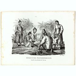
Koreische Fischerfamilie. Famille de pecheurs de Corea.
A Korean family of fishermen playing a board game. No.9' above image. From "Schinz Naturgeschichte und Abbildungen des Menschen der verschiedenen Rassen und Stämme&...
Date: Zürich, 1845
![Generalkarte vom Königreich Preussen u. d. Herz[ogtum] Warschau nach astronomischen Ortsbestim[m]ungen und geodätischen Messungen. . .](/uploads/cache/37060-250x250.jpg)
Generalkarte vom Königreich Preussen u. d. Herz[ogtum] Warschau nach astronomischen Ortsbestim[m]ungen und geodätischen Messungen. . .
Rare seemingly unrecorded map of Poland with its borders after the Congress of Vienna, probably based on a lost first edition of Daniel Friedrich Sotzmann's (1754-1840) m...
Date: Nuremberg, Schneider & Weigel 1815

I Europa / Das dritteil der Welt.
Very early wood cut printed map of Europe with South to the top. In the lower-left corner we see Poland, Livonia and parts of England and Ireland in the lower right corne...
Date: Zurich, Christoffel Froschover, 1548,1552-1566

( II Germania) / Tütschland.
Very early wood cut printed map of Germany, Poland, The Low Countries, Alsace and part Europe with of Switzerland, Croatia. Originally engraved in 1548. Included in "...
Date: Zurich, Christoffel Froschover, 1548,1552-1566

III. Gallia. Franckrych.
Very early wood cut printed map of France, North of river Rhine, Northern Italy. Coast of England from Dover to Cornwall. A ship, sea monsters and coats of arms are filli...
Date: Zurich, Christoffel Froschover, 1548,1552-1566
Selling price: ????
Please login to see price!
Sold in 2025

VII. Das Ergow.
Very early wood cut printed regional map of Switzerland centered on Ergow.Originally engraved in 1548. The map was prepared by Johannes Stumpf (1500-1576). Included in &q...
Date: Zurich, Christoffel Froschover, 1548,1552-1566

IX. Die Lepontier.
Very early wood cut printed regional map of Switzerland.Originally engraved in 1548. The map was prepared by Johannes Stumpf (1500-1576). Included in "Landtaflen. Hi...
Date: Zurich, Christoffel Froschover, 1548,1552-1566
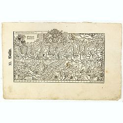
XI. Wallis.
Very early wood cut printed regional map of Switzerland with Wallis region.Originally engraved in 1548. The map was prepared by Johannes Stumpf (1500-1576). Included in &...
Date: Zurich, Christoffel Froschover, 1548,1552-1566

XII. Laurater Basler gelegenheit.
Very early wood cut printed regional map of Switzerland with Basel region.Originally engraved in 1548. The map was prepared by Johannes Stumpf (1500-1576). Included in &q...
Date: Zurich, Christoffel Froschover, 1548,1552-1566
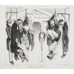
Les honneurs du Panthéon . . . . (Plate 433 from La Caricature.)
On the front wall is written: "To the great men and women, our country is grateful". This lithograph shows people hanging in front of the Panthéon, and may be ...
Date: Paris, October 23, 1834
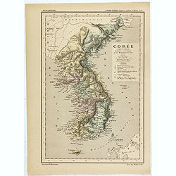
Carte de la Corée d'après la Carte du Dictionnaire coréen-français par les Missionnaires de Corée. . .
Map of Korea called "Corée", which was produced by the French organization Mission Etrangères de Paris (MEP) in 1880. Supposedly, the map was based on Father ...
Date: Paris, 1880

Nieuwe Kaart van het Eyland Sumatra..
Fine chart depicting the Island of Sumatra and the southern coasts of Malaysia from Quedo to Johore. North is orientated to the left of the page. Singapore is probably id...
Date: Amsterdam, 1726

Nieuwe Caart der Eylanden van Banda.
Decorative map of the Banda Islands. Until the mid-19th century the Banda Islands were the world's only source of the spices nutmeg and mace, produced from the nutmeg tre...
Date: Amsterdam, 1726

Mar del Zur, Hispanis Mare Pacificum.
Janssonius' fine chart of the Pacific including the west coast of America with California shown as an island, Japan and a small Australian coastline. This is the earliest...
Date: Amsterdam, 1650

(The City And Harbour Of Sydney From Near Vaucluse.)
One of the most sought after views of the city and harbour of Sydney seen from Near Vaucluse, 1852. Magnificent hand-colored tinted lithograph and finished by gum-Arabic....
Date: London, J. Hogarth, 1852

20 small lithographed views of Washington DC and Georgetown.
20 small lithographed town-views of Washington DC and Georgetown, cut out from a larger sheet. Showing the East Front of the Capitol, Treasury, Smithsonian Institute, Pre...
Date: Casimir Bohn, Washington, D.C.: 1849

ARMENIEN. Costumes de l'Empire Ottoman 9.
A beautiful hand colored lithograph of an Armenian published in the French work "Galerie Royale de Costumes peints d´après nature par divers artistes et lithograph...
Date: Paris, Chez Aubert & Cie., 1842-1848

AFGHAN de CABOULE. Costumes Persans 8.
A beautiful hand colored lithograph of an elegant Afghan from Kabul published in the French work "Galerie Royale de Costumes peints d´après nature par divers artis...
Date: Paris, Chez Aubert & Cie., 1842-1848

Tablaeu de l'Univers premiere partie/ .. seconde partie.
Uncommon and interesting manual containing a double hemisphere world map (with fine outer decoration and showing an imagined great sea in West America, easily the size of...
Date: Luik, Belgium, 1784
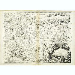
La Transilvania.
A scarce and very attractive detailed map of Transylvania and includes numerous coats of arms in the body of the map and a large decorative title cartouche. Scale cartouc...
Date: Venice, 1696

Kiepert's Physikalische Wandkarten. VI. Nord-America.
Large folding school wall map of North and Central America printed in chromo-lithography. Published by Dieter Reimer and printed by Leopold Kraatz in Berlin. Three inset...
Date: Berlin, Dieter Reimer, 1864

Plan de la rade de Macao (chine) Levé d'après les ordres mr. Rocquemaurel.
Very detailed chart of Macao and several of the surrounding Islands, and features numerous depth soundings throughout. Prepared by captain, Gaston de Rocquemaurel. Logo o...
Date: Paris, c.1856 / 1863
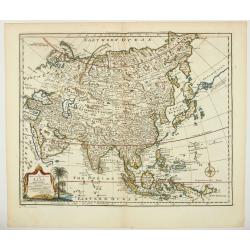
A new & accurate map of Asia drawn from actual surveys. . .
An excellent early engraving of Asia. Curious shape for Japan, with a large island north called Yeso and a coastline marked De Gamma's Land. Numbered "No 52."; ...
Date: London, 1747
Selling price: ????
Please login to see price!
Sold in 2024

Carte générale de L'Empire Ottoman en Europe et en Asie dressée par Henri Kiepert . . .
Large School wall map of Turkish Empire printed in chromo-lithography. Published by Dieter Reimer and printed by Ferdind Barth in Berlin. This rare map has two insets in ...
Date: Berlin, Verlag von Dietrich Reimer, 1867

Wandkarte von Europa von H.Berghaus. . .
Large wall map of Europe printed in chromo-lithography. Prepared by Heinrich Berghaus and published by Justus Perthes in Gotha.Heinrich Berghaus, with support of Alexande...
Date: Gotha, Perthes, ca.1885

Imperii Sinarum nova descriptio.
Schenk and Valk's rare early 18th century issue of Janssonius milestone map of China, Korea and Japan after Martino Martini. Engraved by Johannes van Loon. The overall ba...
Date: Amsterdam, ca. 1720

Kiepert's Physikalische Wandkarten IV. ASIEN. . .
Wall map of Asia printed in chromo lithography. Published by "Stich und Druck der lith. Anst. Von Leopold Kraatz in Berlin". Physical map showing the Asian cont...
Date: Berlin, D. Reimer, 1873

Les Provinces des Pays Bas.
RARE. From his first edition of his only folio atlas, the map is relied upon the map of his uncle, Nicolas Sanson. Engraved by I.Somer.A nice map of Netherlands.
Date: Paris 1687

Il Cuscho citta principale della provincia del Peru.
A very desirable and scarce item of this decorative and early bird's-eye town-plan of the Inca city of Cuzco. Several figures shown inside the city walls and on the hills...
Date: Lyons, 1564
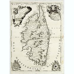
Isola di Corsica, Dedicata all' Em;mo e Rmo: Principe, il Sr. Cardinale Carpegna, Vicario di Sua Santita. . .
One of the most decorative maps of Corsica, with in the upper right, a draped fabric that bears the map's scales is dressed with two angels, one holding the cross, a coat...
Date: Venise, 1692

Novissima et Accuratissima Totius Americae Descriptio.
Second state of Visscher's map of the Americas, this decorative map greatly influenced the cartography of the Americas both geographically and artistically.Although it di...
Date: Amsterdam, 1677
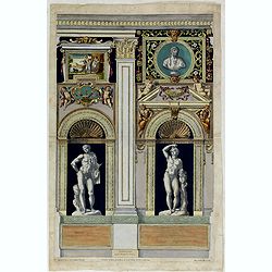
Tabula IV sequitur Farnesiana Posticus.
Ornamental representation of Temple St. Mariae in Rome by Petrus Aquila (1650-1692), after Annibale Carracci. Inscribed in the plate. "Petrus Aquila delin at sculp. ...
Date: Rome, 1660

Riga metropolis Livoniae.
A spectacular panoramic view of Riga, with legends numbered from a-z and 1-16 in German. With the title in a banderol.After a design by Friedrich Bernhard Werner (1690-1...
Date: Augsburg, ca. 1720

Norimberga.
A spectacular panoramic town-view of Nuremberg, with legends numbered from 1-39 in German. With the title in a banderol.After a design by Friedrich Bernhard Werner (1690...
Date: Augsburg, ca. 1720
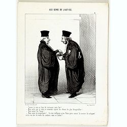
Les Gens de Justice. - Comme je vous ai bien dit vertement votre fait !
Second state (of 2), with text. From "Les Gens de Justice". Text below image : - Comme je vous ai bien dit vertement votre fait !. . . - Mais aussi, que je vous...
Date: Paris, 1845-1848
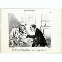
Les Gens de Justice. - Plaidez, plaidez . . . ça sera un bon tour à jouer à votre voisin. . .
Second state (of 2), with text. From "Les Gens de Justice". Text below image : - Plaidez, plaidez . . . ça sera un bon tour à jouer à votre voisin . . . vous...
Date: Paris, 1845-1848

Les Gens de Justice. - Mr. le juge de paix a rendu sa décision, le sparties sont censées conciliées.
Second state (of 2), with text. From "Les Gens de Justice". Text below image : - Mr. le juge de paix a rendu sa décision, le sparties sont censées conciliées...
Date: Paris, 1845-1848

Les Gens de Justice. - Mr. l'avocat a rendu pleine justice au rare talent déployé par le ministère public . . .
Second state (of 2), with text. From "Les Gens de Justice". Text below image : - Mr. l'avocat a rendu pleine justice au rare talent déployé par le ministère ...
Date: Paris, 1845-1848
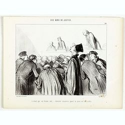
Les Gens de Justice. - L'avocat qui se trouve mal - dernière ressource quand la cause est bien malade.
Second state (of 2), with text. From "Les Gens de Justice". Text below image : - L'avocat qui se trouve mal - dernière ressource quand la cause est bien malade...
Date: Paris, 1845-1848
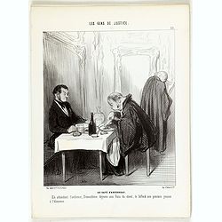
Les Gens de Justice. - Au café d'Aguesseau.
Second state (of 2), with text. From "Les Gens de Justice". Text below image : - Au café d'Aguesseau. En attendant l'audience, Démosthéne déjeune aux frais ...
Date: Paris, 1845-1848
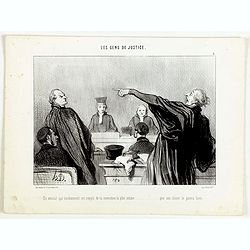
Les Gens de Justice. - Un avocat qui éviemment est rempli de la conviction la plus intime . . .
Second state (of 2), with text. From "Les Gens de Justice". Text below image : - Un avocat qui éviemment est rempli de la conviction la plus intime . . . que s...
Date: Paris, 1845-1848
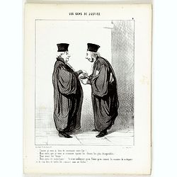
Les Gens de Justice. - Comme je vous ai bien dit vertement votre fait! . . .
Second state (of 2), with text. From "Les Gens de Justice". Text below image : - Comme je vous ai bien dit vertement votre fait! . . . - Mais aussi, je vous ai...
Date: Paris, 1845-1848

The Crimea, chiefly from surveys made by order of the Russian government. . .
Map of Crimea and the Sea of Azov. In lower right corner two inset maps showing Sebastopol inlet and harbour and a second one with the Black Sea. This second maps shows t...
Date: London, 1854

Poli Arctici, et circumiacentium terrarum descriptio novissima. . .
A re-issue of the Hondius' plate. A particularly decorative map of the North Pole with Iceland. Several Dutch names in Labrador. The toponymy in Canada reflects the conti...
Date: Amsterdam, 1660

Carte nouvelle des Terres de Cucan..
Prepared by H.Reland (1676-1718) a professor active in Utrecht and specialized in Asian languages, geography and religions. His first map was a map of Japan copied after ...
Date: The Hague, 1728

Le Grand Mongol. . .
Rare full portrait of the Mongol emperor of Indostan, published by map seller, François Jollain, the Elder (1641-1704), active in Paris, rue St. Jacques à la ville de C...
Date: Paris, ca. 1686
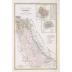
Divisione Militare di Novara. Novara / Lomellina.
Very finely engraved and detailed map of the province of Novara. Upper right corners, two inset plans of Novara and Mortara. Key on the lower right side. Engraved by Vett...
Date: Rome, 1860
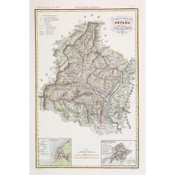
Divisione Militare di Novara. Pallanza / Ossola.
Very finely engraved and detailed map of the region of Novara, including Lago Maggiore to the right. Lower corners, two inset plans of Pallanza and Ossola. Upper right co...
Date: Rome, 1860
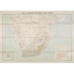
Carte des Missions Catholiques du Sud Africain.
Map of the Catholic Missions in South Africa. Inset map of L'Ile St. Hélène.Published as supplement of the Les Missions Catholiques. To the lower right an inset key to ...
Date: Paris, Monrocq, 1902

Neapolis.
A rare panoramic of Naples with over the whole length of the lower part 3 columns of poems in Latin, Dutch and French.Published by Dancker Danckerts (1634-1666).
Date: Amsterdam, 1660

Manuscript plan of Havana harbour.
Manuscript chart with good nautical detail and soundings of Havana harbour.
Date: Spain c.1820

Carte de la Hongarie a l'Autriche. .
A detailed and scarce map showing Hungary and Austria engraved by de François Lapointe (Lépine). Dated 1664.With a dedication to Ferdinand-Ernest Comte d'Abensperg-Trau...
Date: Paris, 1676

Hundeliebhaberey.
Engraved by Joseph Stöber, (born in Vienna 13. June 1768, died 12 March 1852) after design of Matthäus Loder (1781-1828). From Castelli, "Zerrbilder menschlicher T...
Date: Wien, 1818
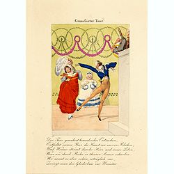
Grimafsirter Tanz.
Engraved by Joseph Stöber, (born in Vienna 13. June 1768, died 12 March 1852) after design of Matthäus Loder (1781-1828). From Castelli, "Zerrbilder menschlicher T...
Date: Wien, 1818
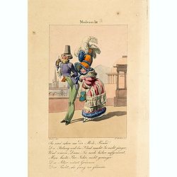
Modesucht.
Engraved by Joseph Stöber, (born in Vienna 13. June 1768, died 12 March 1852) after design of Matthäus Loder (1781-1828). From Castelli, "Zerrbilder menschlicher T...
Date: Wien, 1818
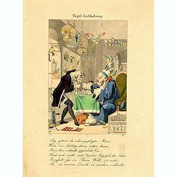
Vogel Liebhaberey.
Engraved by Joseph Stöber, (born in Vienna 13. June 1768, died 12 March 1852) after design of Matthäus Loder (1781-1828). From Castelli, "Zerrbilder menschlicher T...
Date: Wien, 1818