Browse Listings in Europe
![Qua late patet S. Marci area major novum Regim Palatium versus. [Venice, piazza San Marco]](/uploads/cache/49400-250x250.jpg)
Qua late patet S. Marci area major novum Regim Palatium versus. [Venice, piazza San Marco]
View of piazza San Marco, the church of San Geminiano at the far end, figures and market stalls in the foreground.From the series "Prospectum Urbis Venetiarum" ...
Date: Venice, 1763
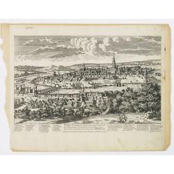
Namur Ville Capitale du Comté de même nom. Elle a este prise par le Roy LOUIS le Grand le 29e Juin 1692.
A very decorative and extremely rare town-view of Namur, including a numbered key (1-12) in the lower part. Engraved by Pierre-Alexandre Aveline. With "fait par Avel...
Date: Paris, ca.1692
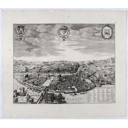
Lugdunum vulgo Lyon.
SCARCE bird's-eye view of Lyon. Adorned with a title cartouche at bottom left, a cartouche at bottom right containing the legend with key tables 1-98 and three coats of a...
- $1000 / ≈ €861
Date: Amsterdam, ca. 1700
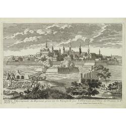
Seville ville Archiepiscopale et capitale du Royaume d'Andalousie en Espagne. . .
A very decorative and extremely rare town view of Seville, including a numbered key (1-37) in the lower part. Engraved by Pierre-Alexandre Aveline. With "fait par Av...
Date: Paris, ca.1692
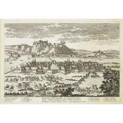
Mons ville capitale du Heynaut, prise sur les Espagnols par Louis le Grand Roy de France. . .
A very decorative and extremely rare town-view of Mons. Engraved by Pierre-Alexandre Aveline. With "fait par Aveline avec privilege du Roy" in lower right margi...
Date: Paris, ca.1692
![Abbaye d'Hautecombe. [Hautecombe Abbey]](/uploads/cache/45509-250x250.jpg)
Abbaye d'Hautecombe. [Hautecombe Abbey]
Showing in great detail a bird's-eye view of the Hautecombe Abbey, a former Cistercian monastery, later a Benedictine monastery, in Saint-Pierre-de-Curtille near Aix-les-...
Date: Amsterdam, 1682
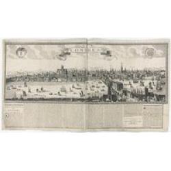
Londres 1678.
Extremely rare panoramic broad sheet panoramic town-view of London from Whitehall to the Tower, with underneath in letter press a description of the town's history. The o...
Date: Paris, 1677

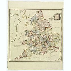
Bowles's new four-sheet map of England and Wales. . .
Bowles's new four-sheet map of England and Wales: Comprehending all the Cities, Boroughs, Market and Sea-Port Towns, Villages, Lakes, Rivers, Forests, Ruins, Canals, and ...
Date: London, 1801
Present Britain.
A fully colored map of England and Wales from An Universal Atlas Consisting of a Complete Set of Maps, peculiarly adapted to illustrate and explain ancient and modern geo...
Date: London, 1797

Les vallées du Piemont. Habitees par les Vaudois ou Berbets. . .
Detailed map of Piedmont region covering French and Italian territories. Surrounded by a French text description "Description des vallées du Piemont qu'habitent par...
Date: Paris, 1690

Vue de l Hotel du Lord Maire, qui comprend la Façade, et le Cot' Occidental de Londres.
Shows the famous Lord Mayor's coach driving through London. The Lord Mayor's coach is famous for its role in the Lord Mayor's Show, which is one of the longest-establishe...
Date: Augsburg, 1750
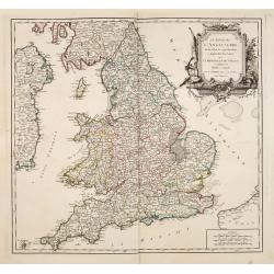
Le Royaume D'Angleterre, divise selon les sept Royaumes ou Heptrachie des Saxons, avec La Principaute De Galles, et subdivisie en Shires ou Comtes…
Decorative map of British Isles divided into the 7 ancient Heptarchies of the Saxons and also showing the more modern counties or shires. With Rococo title cartouche. Eng...
Date: Paris, 1753
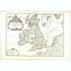
Les Isles Britanniques Comprenant les Royaumes D'Angleterre, D'Ecosse et D'Irlande divisée en grands provinces. . .
Detailed map encompassing present day British Isles. An inset in the upper right details the Shetland and Orkney Islands. Venetian edition of the map by Janvier, to whom ...
Date: Venice, 1776 - 1784
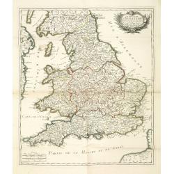
Le royaume d'Angleterre divise en comtez et baronnie. . .
Beautiful map of England, published by le Rouge.
Date: Paris,1745
