Browse Listings
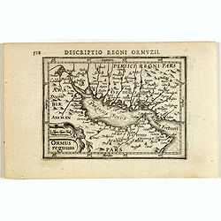
Descriptio Regni Ormuzii / Ormus.
A lovely miniature map of the Kingdom of Ormus, published by Petrus Bertius, and published in Amsterdam at the beginning of the seventeenth century. With an attractive st...
- $450 / ≈ €389
Date: Amsterdam, 1606
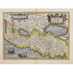
Terra Sancta quae in Sacris Terra Promissionis ol: Palestina.
Map of Palestine on both sides of the Jordan, the shore line running from Berithus (Beirut) to Gaza.Oriented to the east.Largely based on Ortelius 1584 map. In lower left...
- $675 / ≈ €584
Date: Amsterdam, 1606
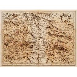
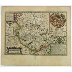
Stiria.
Detailed map of Stiria, the most eastern part of Austria, centered on Graz.Mercator was born in Rupelmonde in Flanders and studied in Louvain under Gemma Frisius, Dutch w...
Date: Amsterdam, 1606

Descriptio Regni Ormuzii / Ormus.
A lovely miniature map of the Kingdom of Ormus, published by Petrus Bertius, and published in Amsterdam at the beginning of the seventeenth century. With an attractive st...
- $450 / ≈ €389
Date: Amsterdam, Cornelis Claes, 1606
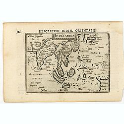
India Orien.
A miniature map showing India and the islands of Borneo, New Guinea, Sumatra, Java, etc.Korea as an enlonged peninsular and one town marked.First published in 1598 in his...
- $400 / ≈ €346
Date: Amsterdam, Cornelis Claes, 1606
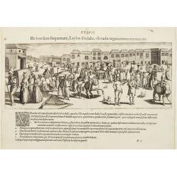
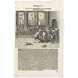
De foro Goae frequentato..
An attractive panorama view of the market square at Goa, with Indians and Portuguese traders, buying and selling various merchandise, with a row of colonial buildings in ...
Date: Frankfurt, 1607
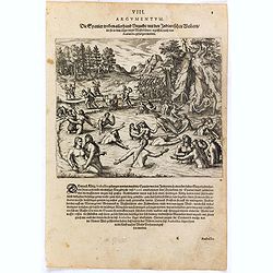
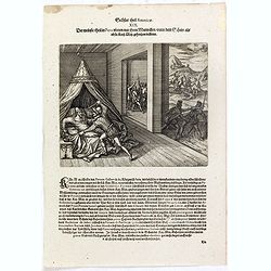
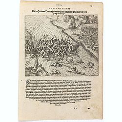
Die Spanier treiben allerhand Unzucht mit den Indianischen Weibern die sie in dem läger unnd Wasserbädern ergriffen nach dem Atabaliba gefangen worden.
Spanish soldiers march past a pool where native American women are bathing. Some of the soldiers drag some of the women away. After the defeat of the Inca king, some of t...
- $150 / ≈ €130
Date: Frankfurt, 1607
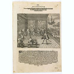
Gonsaluus Pizarrus wird uberwunden gefangen und enthauptet.
Pizarro returned to Spain in 1528 and appealed to the king to grant him permission to conquer Peru. With him, he brought gold and silver, as evidence of their potential w...
- $100 / ≈ €87
Date: Frankfurt, 1607
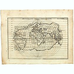
Designatio Orbis Christiani
Planispherical world map broadly based on Ortelius and similar to Hondius's Atlas Minor map of the same title. It shows most of the world, excluding the west coast of Nor...
- $450 / ≈ €389
Date: France, ca 1607
Ferdinandus de Soto Hauptmann uber das Kriegssvolck wardt sampt etlichen anderen von Pizarro, zu dem König Atabaliba abgesandt.
Hernando de Soto on horseback greets a native American carrying a scepter in the shape of a sun.They are surrounded by native American and Spanish soldiers. Includes war ...
- $100 / ≈ €87
Date: Frankfurt, 1607
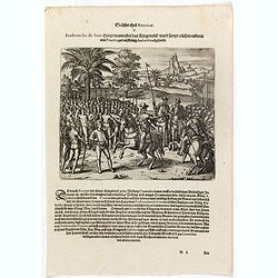
Der König Atabaliba kompt mit grossem Pracht zu Caxamalca an.
The Inca king, Atahualpa or Atabaliba, holding a scepter in the shape of a sun is carried on a litter by native American soldiers. In the background is a fortified city. ...
- $100 / ≈ €87
Date: Frankfurt, 1607
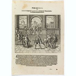
Atabaliba kompt mit Francisco Pizarro ubereyn der Rantzion halben die er für sein erledigung bezahlen solte. . .
Atahualpa or Atabaliba talks to Francisco Pizarro in a room with Spanish soldiers. Includes spears, guns or muskets, and dwellings. Accompanying Pizarro was a monk called...
- $100 / ≈ €87
Date: Frankfurt, 1607
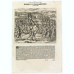
Als dem König Atabaliba zugesagt war dass er widerumb ledig werden solt schickte er die. . .
Spanish soldiers on horseback supervise native Americans who bring gold and silver vessels and statues to a fortified city. Includes vessels, animals such as a lobster, a...
- $100 / ≈ €87
Date: Frankfurt, 1607
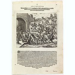
Franciscus Pizarrus lässt den König Atabaliba wider verheissene trew und glauben auff . . .
Atahualpa who is chained to his chair is garroted or executed in a room with Spanish soldiers and blacks [slaves]. Includes spears, gun or musket, headdress, pole and rop...
- $100 / ≈ €87
Date: Frankfurt, 1607
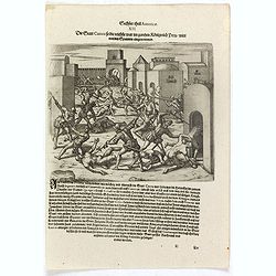
Die Stadt Cuzco so die reichste war in gantzen Königreich Peru wirdt von den Spaniern eingenommen.
Spanish soldiers fight in a fortified town against native Americans. Includes guns or muskets, swords, spears, fortifications, and scene of warfare.After Atahualpa was ki...
- $100 / ≈ €87
Date: Frankfurt, 1607
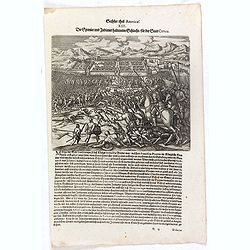
Die Spanier und Indianer halten eine Schlacht für der Stadt Cuzco.
Spanish soldiers, some on horseback, fight before a fortified town against native Americans. Includes guns or muskets, drums, swords, spears, fortifications, and scene of...
- $100 / ≈ €87
Date: Frankfurt, 1607
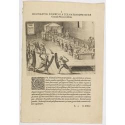
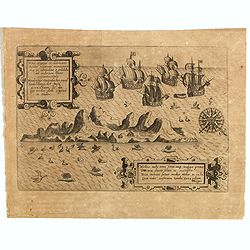
I. Delineatio convivii a Ternatensium rege Generali Neccio exhibiti.
This famous and desirable scene from Roelof Roelofsz's narrative of a voyage by J.C. van Neck to Ternate.Theodore de Bry, a German engraver and book dealer, began a compi...
- $100 / ≈ €87
Date: Frankfurt, Wolfgangi Richteri, 1607
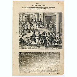
Didacus Almagrus wird von dem Ferdinando Pizarro in gefängnuss geworffen darinnen strangul. . .
Almagro returned to Cuzco, disillusioned and embittered from his long and fruitless journey south into Chile, where he had been searching for further wealth. This led to ...
- $100 / ≈ €87
Date: Frankfurt, 1607
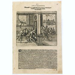
Margraff Pizarrus wird von Didoco Almagro dem jüngern mit hülff seiner Bundgenossen in . . .
Almagro’s son planned to take revenge on Pizarro for his father’s death. In 1541, with the help of Juan de Herrada and other Almagro supporters, they besieged Pizzaro...
- $100 / ≈ €87
Date: Frankfurt, 1607
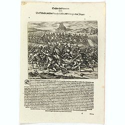
Die Schlacht zwischen Vaca de Castro, und Almagro dem jüngern.
Even before Pizarro’s death, a new royal governor, Vaca de Castro, was on his way to settle the turmoil in Peru. He refused to accept Almagro the younger, when he heard...
- $150 / ≈ €130
Date: Frankfurt, 1607
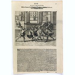
Blascus Nunnez Vela Königlicher Statthalter ersticht den Guillanum Xuarez Königlichen Proc. . .
Life under the new governor, Vaca de Castro, was no more stable than before and the king of Spain was eventually forced to send out yet another governor to replace him. H...
- $150 / ≈ €130
Date: Frankfurt, 1607
Der meinste theil in Peru ubten nur ihren mutwillen under dem schein als ob sie Kay. May. gehorsam leisten.
A Spanish gentleman is stabbed in bed by a soldier. In the background other men are killed or murdered. Includes swords, spears, canopy, and knife. The self-appointed gov...
- $150 / ≈ €130
Date: Frankfurt, 1607
Die Spanier gehen gantz Tyraiñsch mit den Indianern umb welche nicht fort kommen mochten . . .
As Pedro de la Gasca advanced from the north with about 1,500 soldiers, the journey from Trujillo to Ayacucho up the Eastern Cordillera was a terrible experience for the ...
- $100 / ≈ €87
Date: Frankfurt, 1607
![Dess Ferdinandi und Petri de Contreras, gefangene Kriegssknecht werden zu Ranama [sic] durch den Statt Schultheissen mit einem Dolchen durchstochen.](/uploads/cache/37003-250x250.jpg)
Dess Ferdinandi und Petri de Contreras, gefangene Kriegssknecht werden zu Ranama [sic] durch den Statt Schultheissen mit einem Dolchen durchstochen.
Men are stabbed inside prisons while chests are loaded onto a boat. Includes men hanging from a tree seen through a barred window, chains, shackles, pillory, and knife. T...
- $100 / ≈ €87
Date: Frankfurt, 1607
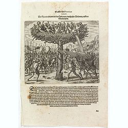
Die Spanier streiten mit den Indianern welche ihre Wohnung auff den Bäumen haben.
Native Americans in trees drop stones, shoot with arrows, and pour water on Spanish soldiers who attack from the ground. One man chops at a tree trunk while two others ho...
- $150 / ≈ €130
Date: Frankfurt, 1607
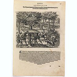
Die Spanier hawen die Bäume darauff die Indianer ihre wohnung haben mit Axten umb und stürtzen sie herunder.
Native Americans in trees drop stones on Spanish soldiers who attack from the ground. One man chops at a tree trunk while two others hold boards over his head to protect ...
- $100 / ≈ €87
Date: Frankfurt, 1607
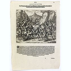
Wie der Indianer Brucken seyen von Seilen zusammen geflochten und vom Farth Guaynacapae.
Native Americans cross a net bridge over a river while one group cuts the end of it causing men to fall into the river and drown. Includes war clubs, spears, bows and arr...
- $100 / ≈ €87
Date: Frankfurt, 1607
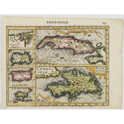
Cuba Insula. Hispaniola.
Decorative engraved map of Cuba above Hispaniola with smaller insets of Havana, Jamaica, Puerto Rico and Margarita.From the first French-text edition of Jodocus Hondius''...
- $300 / ≈ €260
Date: Amsterdam, 1608
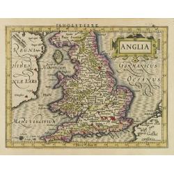
Anglia.
Map of England, from the first French-text edition of Jodocus Hondius'' Atlas Minor.Shortly after the publication of the big folio-atlases the need was apparently felt fo...
- $150 / ≈ €130
Date: Amsterdam, 1608
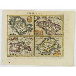
Anglesey Ins. / Wight.. / Ins. Garnesey. / Ins. Iarsey.
A reduced version of Mercator's folio map with four maps on one sheet depicting the English islands of Jersey, Guernsey, Wright and Alderney.Each map is embellished with ...
- $150 / ≈ €130
Date: Amsterdam, 1608

Pascaarte van een deel der Oost Zee, tusschen Bornholm ende der Memel, vertonende de ware gelegentheijt der Zeecusten van Pruijssen. . .
This very rare chart of the Northern Coast of Poland with Gdansk, appeared in the rare English edition of Willem Blaeu's 'Het Licht der Zeevaert', an atlas of sea charts ...
- $4000 / ≈ €3462
Date: Amsterdam, 1608
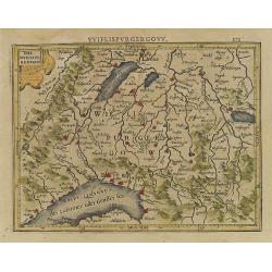
Das Wiflispurgergou.
Reduced version of Mercator''s map of the southwestern part of Switzerland. Shows Geneva, Lake Geneva, Lake Neuchatel, Lake Biel, Bern, Freiburg, Lake Thuner, etc.From th...
- $75 / ≈ €65
Date: Amsterdam, 1608
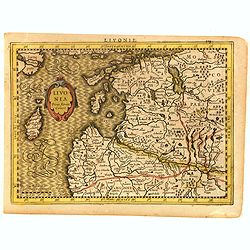
Livonia.
Scarce miniature map of Lithuania, from the first French-text edition of Jodocus Hondius' Atlas Minor. Engraved by Pieter Van Den Keere.Shortly after the publication of t...
- $300 / ≈ €260
Date: Amsterdam, Cloppenburgh, 1608
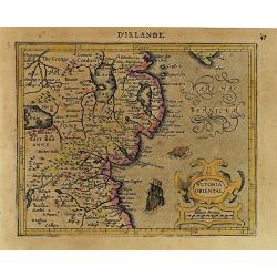
Ultonia Oriental.
Map depicting part of Ulster, with the south-western tip of Scotland in the upper right. From the first French-text edition of Jodocus Hondius' Atlas Minor.Shortly after ...
- $75 / ≈ €65
Date: Amsterdam, 1608
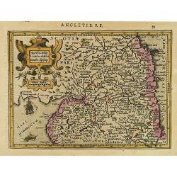
Northumbr. Cumberladia Dunelm. Episcop.
A map of the most northern part of England, from the first French-text edition of Jodocus Hondius' Atlas Minor.Shortly after the publication of the big folio-atlases the ...
- $100 / ≈ €87
Date: Amsterdam, 1608
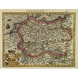
La Germanie.
Small map of Germany, including Austria and part of Poland. Strap work title cartouche in the lower left.From the first French-text edition of Jodocus Hondius' Atlas Mino...
- $75 / ≈ €65
Date: Amsterdam, 1608
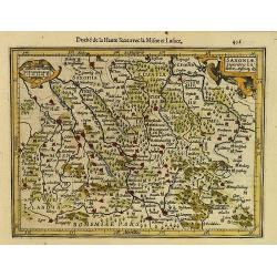
Saxonia Inferior et Mekleburg.
Detailed map showing part of northern Germany. With major cities of the area named.From the first French-text edition of Jodocus Hondius' Atlas Minor.Shortly after the pu...
- $80 / ≈ €69
Date: Amsterdam, 1608
Saxoniae Superioris Lusatiae..
Detailed map of Saxony. With Prague at the bottom. From the first French-text edition of Jodocus Hondius' Atlas Minor.Shortly after the publication of the big folio-atlas...
- $50 / ≈ €43
Date: Amsterdam, 1608
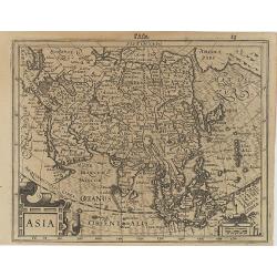
Asia.
Map of Asia with an oversized Korea and a curious shape for Japan, from the first French-text edition of Jodocus Hondius' Atlas Minor.Shortly after the publication of the...
Date: Amsterdam, 1608
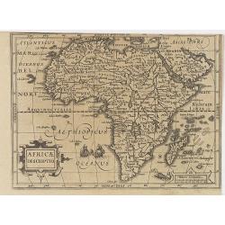
Africae Descriptio.
Map of Africa from the first French-text edition of Jodocus Hondius' Atlas Minor.Shortly after the publication of the big folio-atlases the need was apparently felt for a...
Date: Amsterdam, 1608
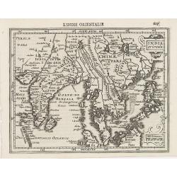
Indiae Orientalis.
This map covers an area including India, part of Malaysia, Borneo and China.From the first French-text edition of Jodocus Hondius' Atlas Minor.Shortly after the publicati...
Date: Amsterdam, 1608
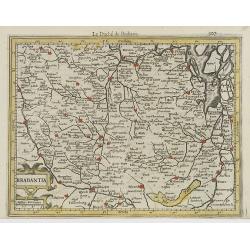
Brabantia.
Decorative regional map of northern Belgium and the Dutch province Brabant, extending north to Breda and south to Namur, with Antwerp and Brussels near the center.Oriente...
- $150 / ≈ €130
Date: Amsterdam, 1608
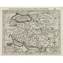
Persicum Regnum.
Early map of Persia, from the first French-text edition of Jodocus Hondius' Atlas Minor.Shortly after the publication of the big folio-atlases the need was apparently fel...
- $100 / ≈ €87
Date: Amsterdam, 1608
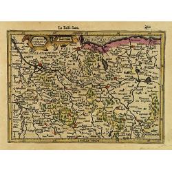
Totius Lemovici et . . .
Map of part of France, centered on Limoge, including a plan of Limoge. Prepared by Jean du Fayen (1530-1612), French physician and geographer, who prepared the first know...
Date: Amsterdam, 1608

Udrone.
Map depicting present-day County Carlow in Leinster Province & Catherlaugh which is now Carlow. From the first French-text edition of Jodocus Hondius' Atlas Minor.Sho...
- $150 / ≈ €130
Date: Amsterdam, 1608
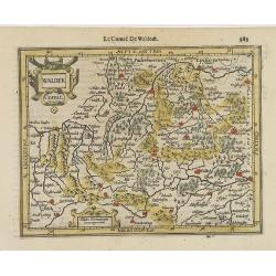
Waldek Comit.
Early map of the region surrounding Waldeck, northern Hessen. From the first French-text edition of Jodocus Hondius' Atlas Minor.Shortly after the publication of the big ...
- $45 / ≈ €39
Date: Amsterdam, 1608
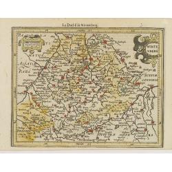
Wirtenberg.
Detailed map centered on Baden-Württemberg. With major cities of the area named.From the first French-text edition of Jodocus Hondius' Atlas Minor. Shortly after the p...
- $40 / ≈ €35
Date: Amsterdam, 1608
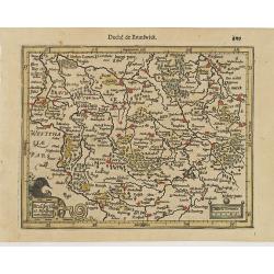
Brauswik et Meydburg com confinijs.
Detailed map showing the region around Brunswick and Magdeburg. With major cities of the area named.From the first French-text edition of Jodocus Hondius' Atlas Minor.Sho...
- $50 / ≈ €43
Date: Amsterdam, 1608
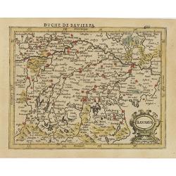
Bavaria.
Detailed map showing part of Bavaria. It covers the area between Ingolstadt and Salzburg.From the first French-text edition of Jodocus Hondius' Atlas Minor.Shortly after ...
- $50 / ≈ €43
Date: Amsterdam, 1608
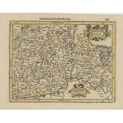
Palatinat. Bavariae.
Detailed map showing part of Bavaria. It covers the area between Ingolstadt, Nuremberg and Regensburg.From the first French-text edition of Jodocus Hondius' Atlas Minor.S...
- $50 / ≈ €43
Date: Amsterdam, 1608
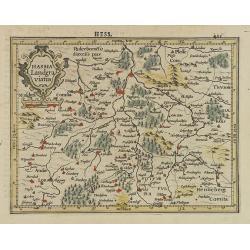
Hassia Landgraviatus.
Detailed map showing the region around Kassel. With major cities of the area named.From the first French-text edition of Jodocus Hondius' Atlas Minor.Shortly after the pu...
- $50 / ≈ €43
Date: Amsterdam, 1608
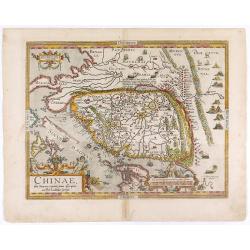
Chinae, olim Sinarum regionis. . .
The first printed map of China. It is signed by Ludovico Georgio, whose real name was Luis Jorge de Barbuda. He was a Portuguese Jesuit cartographer and besides that a sp...
- $6000 / ≈ €5193
Date: Antwerp, 1608
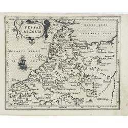
Fessae Regnum.
Charming small map of the northwestern tip of Africa with Fez showing as the principal city. Decorative title cartouche.From a Latin-text edition of Jodocus Hondius' Atla...
- $120 / ≈ €104
Date: Amsterdam, 1608
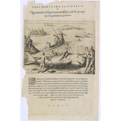
Pars Undecima Orientalis X. Quomodo in Septentrionalibus insulis prope. (How the inhabitants catch whales off the east coast of Madagascar.)
How the inhabitants catch whales off the east coast of Madagascar. When the natives of Santa Marta, off the east coast of Madagascar see a whale, they row out in their li...
- $100 / ≈ €87
Date: Frankfurt, 1609
Insula D.Helenae sacra coeli Clementia . . .
A fine perspective view of the Island of St.Helena in the South Atlantic. The location of the Island directly on the navigation route from Europe to the Cape of Good Hope...
- $750 / ≈ €649
Date: Frankfurt, 1609
Vera effigies et delineatio Infulce Ascenstio. . . (St. Helena)
Striking view of the Island of Ascuncion (St. Helena).Theodore de Bry, a German engraver and book dealer, began a compilation of early voyages in 1590 and had published s...
Date: Frankfurt, 1609
![[Titlepage] Nomenclator Ptolemaicus..](/uploads/cache/06436-250x250.jpg)
[Titlepage] Nomenclator Ptolemaicus..
Title page from a Ortelius Atlas part called: Nomenclator , containing a register of place names in antiquity. Letterpress with copper engraved print (60x60mm) of the eas...
- $150 / ≈ €130
Date: Antwerp, 1609
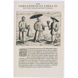
Mercatorum Ex China in Bantam Negotiantium Schema.
An early portrait of Chinese merchants in Banten (Bantam), a small port town near Java's western end.Theodore de Bry, a German engraver and book dealer, began a compilati...
- $100 / ≈ €87
Date: Frankfurt, 1609
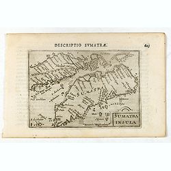
Sumatra Insula.
A miniature map of Sumatra containing detailed geography and nomenclature around the entire island. The neighbouring coast of the Malay Peninsula is shown, including Sing...
- $450 / ≈ €389
Date: Amsterdam/Frankfurt 1609
![[Sunda].](/uploads/cache/37956-250x250.jpg)
[Sunda].
Text engraving and coastal profiles in wood block from "Premier livre de l'histoire de la navigation aux Indes Orientales, par les hollandois, et des choses a eux ad...
Date: Amsterdam, Cornille Nicolas, 1609
II Pars Indiae Orientalis in qua Johan. Hugonis Linschotani. . .
De Bry's Part II of his "Les Petit Voyages", containing "Pars Indiae Orientalis, in qua Johan. Hugonis Linscotani navagatio in Orientem, 1609", being ...
Date: Frankfurt, Wolffgang Richter, 1609
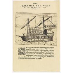
XXVII. Triremes seu Galiottae et Fustae Iavenenfium. 21. ( A typical Javanese man-of-war ship)
A typical Javanese man-of-war ship. The Javanese call their man-of-war ships, Cathurs. The slaves are all seated below deck and do the rowing with oars, while the warrior...
- $150 / ≈ €130
Date: Frankfurt, 1609
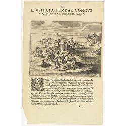
V. Inusitata Terrae Concussio, in Insula S. Michael Facta.
Showing the Vila Franca earthquake on 26 July 1591Theodore de Bry, a German engraver and book dealer, began a compilation of early voyages in 1590 and had published six p...
- $75 / ≈ €65
Date: Frankfurt, 1609
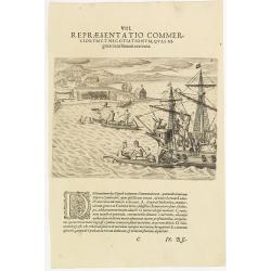
VIII. Repraesentatio Commerciorum et Negotiationum, Quas Nigritae cum Batauis exercent.
Locals from Gold Coast trying to sell items to the crew of a Dutch vessel. Theodore de Bry, a German engraver and book dealer, began a compilation of early voyages in 159...
- $100 / ≈ €87
Date: Frankfurt, 1609
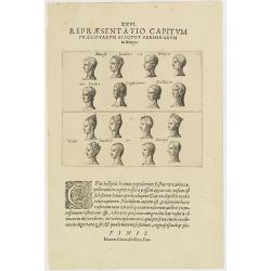
XXVI. Repraesentatio Capitum Praecipuarum Aliquot Personarum in Benyn.
Different types from Benin, in West Africa.Theodore de Bry, a German engraver and book dealer, began a compilation of early voyages in 1590 and had published six parts at...
- $75 / ≈ €65
Date: Frankfurt, 1609
![[Description de la Figure de la ville de Gammelamme - Description du N° 15]](/uploads/cache/43504-250x250.jpg)
[Description de la Figure de la ville de Gammelamme - Description du N° 15]
View of the town of Gammelamme [Gamalama] on Ternate, where the Dutch established a trading post. Text engraving from "Premier livre de l'histoire de la navigation a...
- $50 / ≈ €43
Date: Amsterdam, Cornille Nicolas, 1609
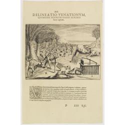
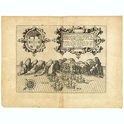
XII. Delineatio Venationum, quomodo Nimir um Omnis Generis feras capiant. (How the hunters catch animals: 1603-1604)
A: shows a leopard walking into a cage with a trap door. B: is an antelope, killed by natives, using ‘assagais’. C: shows rabbits being caught. They are frightened ou...
- $125 / ≈ €108
Date: Frankfurt, 1609
![[Navigational chart].](/uploads/cache/37971-250x250.jpg)
[Navigational chart].
Two text engravings from "Premier livre de l'histoire de la navigation aux Indes Orientales, par les hollandois, et des choses a eux advenues . . . ", being the...
Date: Amsterdam, Cornille Nicolas, 1609
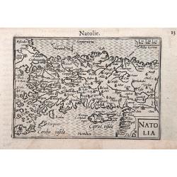
Natolia.
A miniature map of the Arabian peninsula, including Cyprus. The title cartouche on the lower right corner.First published in 1598 in his Caert-Thresoor, the plates were e...
- $200 / ≈ €173
Date: Amsterdam / Frankfurt, 1609
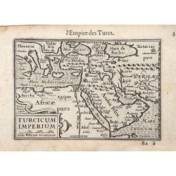
Turcicum Imperium / Empire Turc.
A miniature map of the Arabian peninsula, centered on Jerusalem. Title cartouche on the lower left corner.First published in 1598 in his Caert-Thresoor, the plates were e...
Date: Amsterdam/Frankfurt 1609
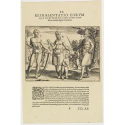
XX. Repraesentatio Eorum Quae Praeterea in Cabo Lopo Gonfalues. . . (More inhabitants of Cabo Lopo Gonsalues)
Here we see more figures of Cabo Lopo Gonsalues and Rio de Gabon. A: a distinguished man decked out in his finery and carrying several types of knives in his belt. In his...
- $100 / ≈ €87
Date: Frankfurt, 1609
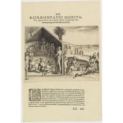
XIX. Repraesentatio Maiestatis, qua rex in Cabo Lopo Gonsalves . . . (How the chief of Cabo Lopo Gonsalues presents himself )
This describes the places they call Cabo Lopo Gonsalues and Rio de Gabon, where the chief receives his visitors. He sits on a chair placed upon a platform with two or thr...
- $100 / ≈ €87
Date: Frankfurt, 1609
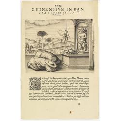
Chinensium in Bantam Superstitio et idololatria. 18. ( How the Chinese worship their idols in Bantam)
How the Chinese worship their idols in Bantam. As can be seen here, the Chinese worship their idol, which takes the form of a devil. They lay offerings of fruit on an alt...
- $100 / ≈ €87
Date: Frankfurt, 1609
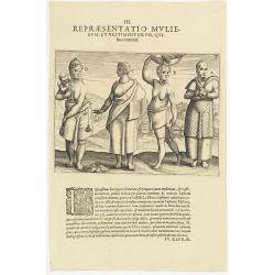
III. Repraesentatio Mullierum, et vestimentorum, Quibus Utuntur.
Inhabitants of the coast of the Ivory coast in Africa.Theodore de Bry, a German engraver and book dealer, began a compilation of early voyages in 1590 and had published s...
- $75 / ≈ €65
Date: Frankfurt, 1609
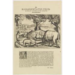
XI. Repraesentatio Pecorum et animalium in Guinea cicuratorum.
Various animals and birds from Africa. Engraved and published by Theodore de Bry, a German engraver and book dealer, began a compilation of early voyages in 1590 and had ...
- $100 / ≈ €87
Date: Frankfurt, 1609

XIII. Repraesentatio Bestiarum ferarum Omnis Generis, quales in Guinea reperiuntur.
Fine engraving of Elephant and other wild animals. Theodore de Bry, a German engraver and book dealer, began a compilation of early voyages in 1590 and had published six ...
- $100 / ≈ €87
Date: Frankfurt, 1609
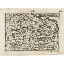
Hassiae Descriptio / Hesse.
A miniature map centered on the province of Hessen. The title cartouche on the upper right corner.First published in 1598 in his Caert-Thresoor, the plates were executed ...
- $50 / ≈ €43
Date: Amsterdam / Frankfurt, 1609
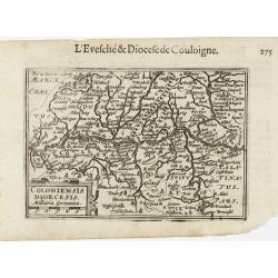
Coloniensis Diocesis.
A miniature map centered on Cologne. Title cartouche on the lower left corner.First published in 1598 in his Caert-Thresoor, the plates were executed by the most famous e...
- $80 / ≈ €69
Date: Amsterdam / Frankfurt, 1609
![[Chinese Merchants and temple].](/uploads/cache/37966-250x250.jpg)
[Chinese Merchants and temple].
Two text engravings of Chinese merchants on Java and a Chines temple from "Premier livre de l'histoire de la navigation aux Indes Orientales, par les hollandois, et ...
- $100 / ≈ €87
Date: Amsterdam, Cornille Nicolas, 1609
![[Native Flora of Java].](/uploads/cache/37964-250x250.jpg)
[Native Flora of Java].
Text engraving of native flora of Java from "Premier livre de l'histoire de la navigation aux Indes Orientales, par les hollandois, et des choses a eux advenues . . ...
- $75 / ≈ €65
Date: Amsterdam, Cornille Nicolas, 1609