Browse Listings in Europe > Mediterranean & Islands > Mediterranean

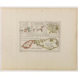
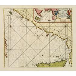
Sardinia / Sicilia.. / Corfu / Zerbi.. / Elba / Malta. . .
Six very fine and early maps on one sheet. Including the islands of Sicily, Corfu, Sardinia, Zerbi (Djerba), Elba and Malta.The map of Malta has a sinking ship at Cala di...
Date: Antwerp, 1570-1612
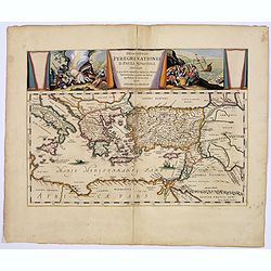
Descriptio Peregrinationis D. Pauli, Apostoli. . .
A striking map of the Mediterranean Sea and its surrounding areas. It depicts the travels of the Apostle St. Paul.The pair of decorative cartouches, presented in a curtai...
Date: Amsterdam, 1650
L'Isle de Malte avec ses Voisines./ La Valete Forte..
Uncommon map Malta. Four maps on one sheet. With inset maps of Valletta.Like Sanson, Briet was born in Abbeville and became a Jesuit at age 18. His "Parallela Geogra...
Date: Paris, 1653
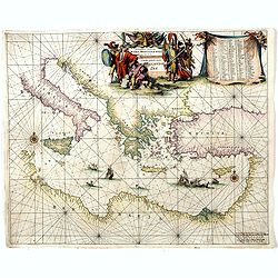
Orientalior districtus Maris Mediterranei.
Beautiful chart of the eastern part of the Mediterranean. Including Italy, the north coast of Africa and part of the Black Sea.The entire sheet is covered with rhumb line...
Date: Amsterdam, 1675
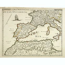
La mer mediterrannée, vers l'Occident. . .
Uncommon map of the western Mediterranean Sea, including France, Spain, Italy, Corsica Sardinia and North Africa. In upper left corner a large sailing vessel.
- $300 / ≈ €262
Date: Paris, 1676
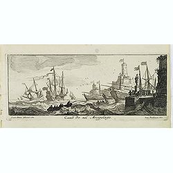
Canistro nel Arcipelago.
Magnificent view of Kanaestreo and its harbour front, decorated with ships and rowing boats in a rough sea. Engraved by Lucas Vostermans II, who was born in 1624, in the ...
- $100 / ≈ €87
Date: Antwerp, c.1690
Paskaart der Zeekusten van Italien Tusschen Piombino en C. dell Arme Met de Noord-kust van 't Eylandt Sicilia..
Centered off the Ponziane Islands, this sea chart covers the area of the Tyrrhenian Sea, delimited by Sardinia, the Elba island, the Strait of Messina and Trapani. It con...
- $1000 / ≈ €874
Date: Amsterdam, 1708
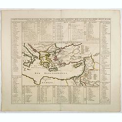
Carte geographique de l'Asie mineure avec un etat des premiers rois. . .
Map of the Mediterranean. This impressive engraving is a wonderful example of Chatelain’s elegant plates from his "Atlas Historique, Ou Nouvelle Introduction A L�...
- $120 / ≈ €105
Date: Amsterdam, ca. 1720

Turquie Européenne, Avec les Pays limitrophes. . .
Copper engraved map centered on Greece, extending northwards and eastwards to include the Balkans and Ukraine as well as Cyprus.The map is flanked by two columns of Frenc...
- $50 / ≈ €44
Date: Paris, 1790
