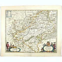
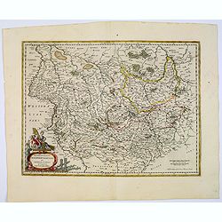
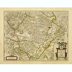
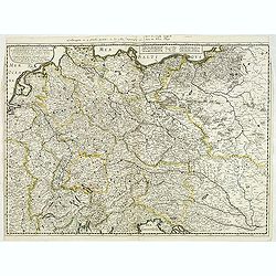
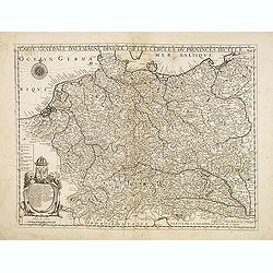
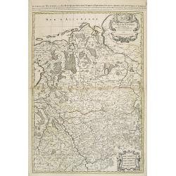
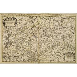
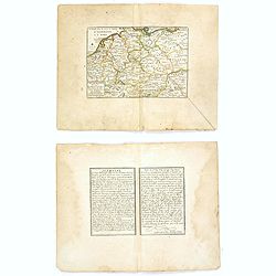
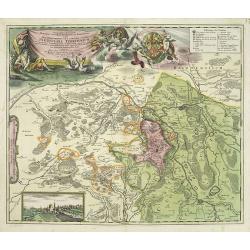
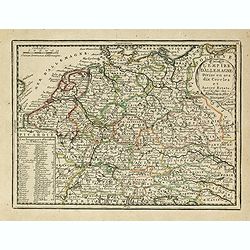
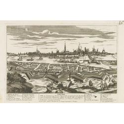
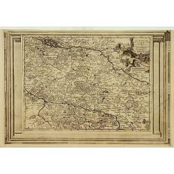
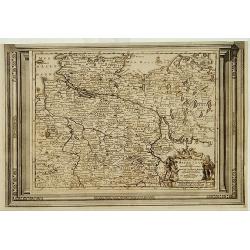
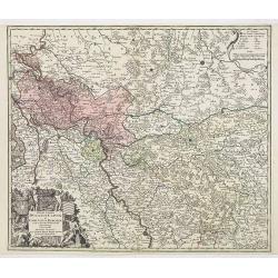
Comitatus Glatz.
Nice map by Willem Blaeu of the Silesia region with Glatz (Klodzko) at center. The forested region was renowned for its wild game and the map includes tiny illustrations ...
- $450 / ≈ €393
Date: Amsterdam, 1644
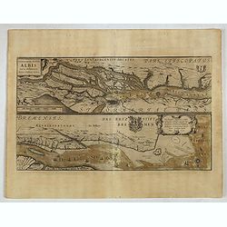
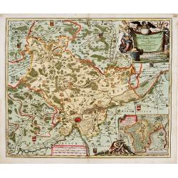
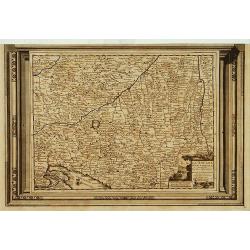
Celeberrimi Fluvis Albis nova delineatio. . .
A decorative map from a 1640's Latin text edition of Blaeu's "Theatrum Orbis Terrarum, Sive Atlas Novis." The River Elbe is depicted in two sections from the mo...
- $80 / ≈ €70
Date: Amsterdam, 1644
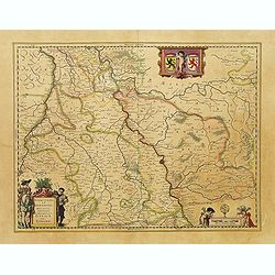
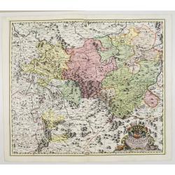
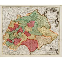
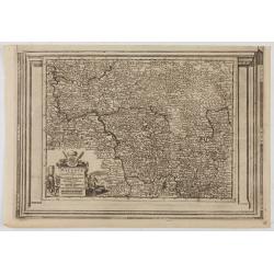
Juliacensis et Montensis Ducatus / De Hertoghdomen Gulick en Berghe.
Detailed map centered on Cologne. Embellished with scale cartouche with cherubs, a cartouche with a putti inside holding two coats of arms. Lower left corner, the title c...
- $150 / ≈ €131
Date: Amsterdam, 1645
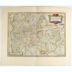
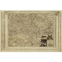
Monasteriensis Episcopatus.
A very detailed map of Germany centered on Linge. Showing Wessel to the top of the map, and Oldenburg to the right. North is oriented to the right. The map is further ado...
Date: Amsterdam 1645
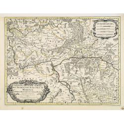
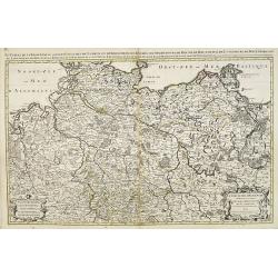
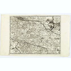
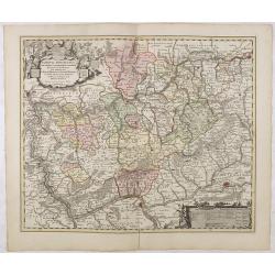
Archiepiscopatus Maghdeburgensis et Anhaltinus Ducatus.
A very nice, decorative copper engraved map of Lower-Saxony and Saxony-Anhalt by Blaeu. With one figural cartouche. Bounded on the west by the River Wesel between Nienbur...
- $80 / ≈ €70
Date: Amsterdam, 1645
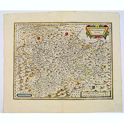
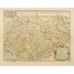
Wirtenberg Ducatus.
Map depicting the area south of Heidelberg, including Stuttgart, Ulm, etc.. and river Danube.A beautiful coat of arms and a splendid title cartouche decorated by three ch...
Date: Amsterdam, 1645
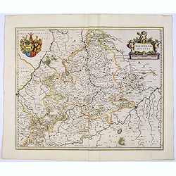
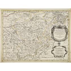
Waldeck Comitatus.
Blaeu's attractive map of the region of Waldeck. Forests, hills and rivers all feature, along with towns villages and cities. Decorative title cartouche surmounted by coa...
- $100 / ≈ €87
Date: Amsterdam, 1645
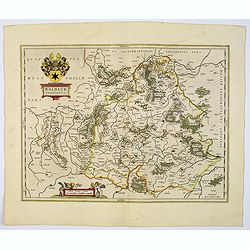
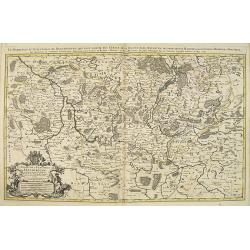
Westphalia Ducatus.
Originally engraved for Jodocus Hondius II, at his death in August 1629, this map was, among 39 other copper plates, purchased by Willem Blaeu who deleted Hondius' name a...
Date: Amsterdam, 1645
Territorium Abbatiae Herefeldensis - 't Stift Hirszfeldt.
Detailed map centered on Hirschfelt. Title cartouche embellished with two cherubs.
- $250 / ≈ €218
Date: Amsterdam, 1647
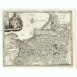
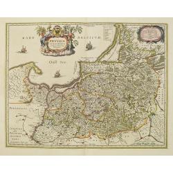
Prussiae nova tabula.
Rare map of Prussia with nowadays Poland. The map features a bold title cartouche, a ship, compass rose, and a sea monster in the Baltic Sea. The map was prepared by the ...
- $550 / ≈ €480
Date: Amsterdam, 1647
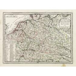
Estats de la Succession de Cleves/ Iuliers..
Fine map of western Germany.This edition carries the date 1650 and the publishers address A PARIS chez l'Autheur aux Galleries du Louvre. Nicolas Sanson was to bring abou...
Date: Paris 1650
Haute Saxe.. Duche de Saxe... / Marquisat de Misnie..
Fine map of Saxony.This edition carries the date 1655. Engraved by R.Cordier Abbauil.Nicolas Sanson was to bring about the rise of French cartography, although the fierce...
- $100 / ≈ €87
Date: Paris, 1655
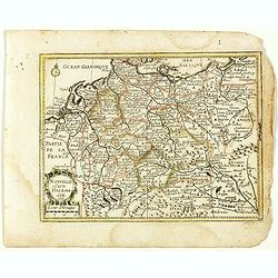
Carte generale de L'Empire d'Allemagne et pays circonvoisins. . .
Fine map of Germany, Low countries, Switzerland, Austria and Poland. The map was first published by Tavernier and later by Mariette. This edition carries the date 1642 an...
- $200 / ≈ €175
Date: Paris, 1642/45-1657
Prussia accurate descriptia a Gasparo Henneberg Erlichensi.
Prussia and the Baltic Region, with two large decorative cartouches, coat of arms and three sailing ships. As indicated in the title cartouche, the map was prepared by th...
- $900 / ≈ €786
Date: Amsterdam, 1660
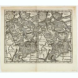
Populorum Germaniae . . .
Two maps of historical Germany on a single sheet. The two maps appear identical at first glance, but actually are a comparison of the region during the reigns of differen...
- $50 / ≈ €44
Date: Amsterdam, 1661
Nouvelle Carte d'Allemagne 1651. (29).
Scarce map of Germany, Poland and the Low Countries, published by Antoine de Fer in 1661 or 1662 in "Cartes de géographie revues et augmentées". With number 2...
- $50 / ≈ €44
Date: Paris, Antoine de Fer, 1657 but 1661 or 1662
Carte générale d'Alemagne divisée par les cercles ou provinces d'icelle.
Rare and detailed map of Germany, Poland and Austria, engraved by H. le Roy in 1643 or 1666 for Jacques L'Agniet. The publishing house Jollain bought the copper plate and...
Date: Paris, 1666
La Souabe.
Fine map of Swabia.This edition carries the date 1674 and the publishers address A PARIS chez l'Autheur aux Galleries du Louvre. Nicolas Sanson was to bring about the ris...
- $75 / ≈ €66
Date: Paris, 1674
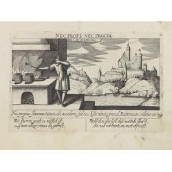
Croneburg.
A very nice picture representing the castle of Croneburg, of the German town of Kronenburg (now part of Dahlem). On the foreground, a man entertaining a fire is depicted....
- $75 / ≈ €66
Date: Frankfurt, 1623-1678
![Merla in Ob. Hessen. [Merlau]](/uploads/cache/13826-250x250.jpg)
Merla in Ob. Hessen. [Merlau]
A panoramic view of the castle and town of Merlau in Hessen. In the foreground, two men fighting each other are depicted. With a verse in two languages underneath the pic...
- $40 / ≈ €35
Date: Frankfurt, 1623-1678
Haute Partie de la Basse Saxe..
Fine map of the northeastern part of Germany, including Hamburg and the rivers Wesel and Elbe. This edition carries the date 1679. Nicolas Sanson was to bring about th...
Date: Paris, 1679
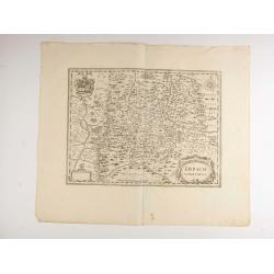
Erpach.
The town of Heidelberg is in most southern point on the map, including the rivers Rhine, Necker and Main.Rare issue published in Oxford. In 1680 the copper plates of Jans...
- $100 / ≈ €87
Date: Oxford, 1680
Nova Totius Westphaliae descriptio.
Map of the northern provinces of Germany, including the Wad islands. West to the top. Including Bremen, Hildesheim, Kassel, Düsseldorf, etc. Also including the Dutch pro...
Date: Amsterdam, 1680
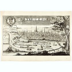
Treves (Trier)
Rare and decorative view of the city of Trier and the river Moselle in the foreground. In the upper left corner the coat of arms of France. The Jollain family was a famil...
Date: Paris, 1680
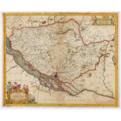
Tabula Geographica Novissima Ducatus Stormariae in Meridionali Parte Holsatiae.
A rare and beautiful map of the region of Germany around Hamburg. Fine detailed topography, including roads, fortifications, cities and villages. The title cartouche is s...
Date: Amsterdam, 1681
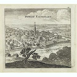
Donau Eschingen. / Der donaü stränd.
Two views pasted on recto and verso of a larger sheet of paper. On recto panoramic view of Donaueschingen a German town in the Black Forest.On verso a map of the Danube a...
- $75 / ≈ €66
Date: Nuremberg, Jacob Sandrart, 1684
Carte générale d'Alemagne divisée par les cercles ou provinces d'icelle.
Rare and detailed map of Germany, Poland and Austria, engraved by H. le Roy in 1643 or 1666 for Jacques L'Agniet. Published by François Jollain (ca. 1641 – 18 April 17...
- $450 / ≈ €393
Date: Paris, 1689
La Prussia Divisa in Reale Che Appartiene al Ré Di Polonia et in Ducale Che Spetta all'Elettore Di Brandeburgo. Da Giacomo Cantelli Da ...
In the upper left-hand corner a large title cartouche with a dedication to Cardinal Denhoff. The map is dated 1689.The cartographer was Giacomo Cantelli (1643-1695) who w...
- $1000 / ≈ €874
Date: Rome, 1689
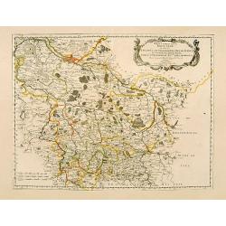
Cercle de Westphalie.
Fine map of Westphalia. The address is much re-worked, now with the address Chez L'Autheur aux Galleries du Louvre , dated 1690.This edition carries the date 1690 and the...
- $100 / ≈ €87
Date: Paris 1690
Le Cercle de Westphalie . . .
Fine map of the Westphalia Duchy with a decorative cartouche and small scale of miles.Alexis-Hubert Jaillot (1632-1712), was a French cartographer. He joined the Sanson...
- $150 / ≈ €131
Date: Amsterdam, 1692
Partie Occidentale du Temporel de l'Archevesché et Eslectorat de Mayence . . .
Fine map of area around Mainz and Frankfurt, decorated with two decorative title and scale cartouches.Alexis-Hubert Jaillot (1632-1712), was a French cartographer. He joi...
- $150 / ≈ €131
Date: Amsterdam, 1692
Le Duché de Westphalie . . .
Fine map of the Westphalia Duchy with the River Ruhr, Decorative title and scale cartouche.Alexis-Hubert Jaillot (1632-1712), was a French cartographer. He joined the S...
- $150 / ≈ €131
Date: Amsterdam, 1692
Le marquisat et electorat de Brandebourg
Fine map of Brandenburg with a decorative title and scale cartouche.Alexis-Hubert Jaillot (1632-1712), was a French cartographer. He joined the Sanson heirs and redrew Ni...
- $100 / ≈ €87
Date: Amsterdam, 1692
Le cercle de la haute saxe ou sont compris le duche et electorat de Saxe. . .
Fine map of Saxe with a decorative title and scale cartouche.Alexis-Hubert Jaillot (1632-1712), was a French cartographer. He joined the Sanson heirs and redrew Nicolas S...
- $250 / ≈ €218
Date: Amsterdam, 1692
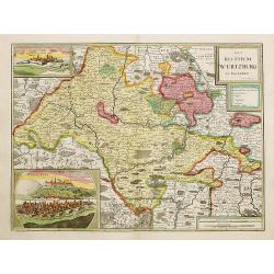
Das Bisthum Wurtzburg in Francken.
Rare map of Würzburg. With inset panoramic views of Würzburg and Köningshofen.The map is painted in strong colors. Clearly from an show-piece atlas produced for a weal...
Date: Nurenberg 1698
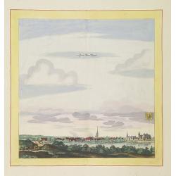
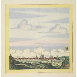
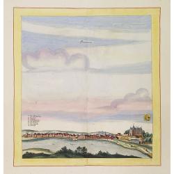
Zerbst.
Very decorative and rare panoramic town view of Zerbst in Bez, Magdeburg.The engraver and publisher of prints, Mrs. Anna Beek of the Hague, enlarged the print and mounted...
Date: The Hague, ca. 1700
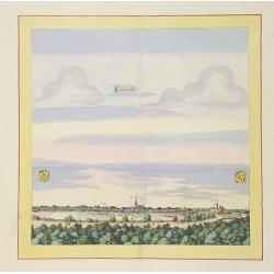
Eilenburg.
Very decorative and rare panoramic view of Eilenburg a.d. Mulde.The engraver and publisher of prints, Mrs. Anna Beek of the Hague, enlarged the print and mounted it on la...
Date: The Hague, ca. 1700
Statt Alten Rüppin.
Very decorative and rare panoramic town-view of Statt Alten Rüppin.The engraver and publisher of prints, Mrs. Anna Beek of the Hague, enlarged the print and mounted it o...
Date: The Hague, ca. 1700
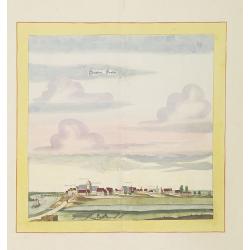
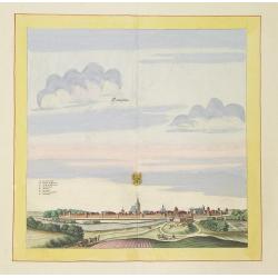
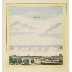
Stättlein Frohsa.
Very decorative and rare panoramic town view of Frohse a.d. Elbe, Bez. Magdeburg.The engraver and publisher of prints, Mrs. Anna Beek of the Hague, enlarged the print and...
Date: The Hague, ca. 1700
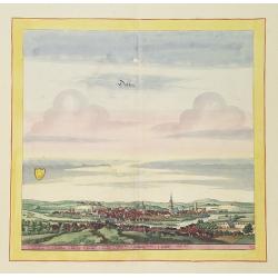
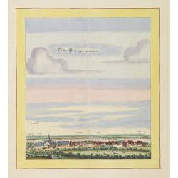
Döblen.
Very decorative and rare panoramic of Döblen in Sachsen.The engraver and publisher of prints, Mrs. Anna Beek of the Hague, enlarged the print and mounted it on larger p...
Date: The Hague, ca. 1700
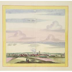
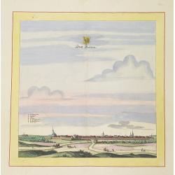
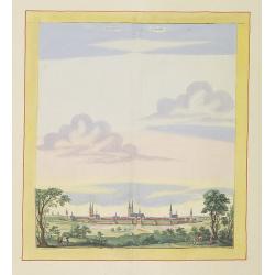
Stättlein Saltza.
Very decorative and rare panoramic town view of Salzelmen Bad Salzemen, Bez. Magdeburg. The engraver and publisher of prints, Mrs. Anna Beek of the Hague, enlarged the pr...
Date: The Hague, ca. 1700
Seehaüsen.
Very decorative and rare panoramic of Seehausen, Altmark, Bez. Magdeburg .The engraver and publisher of prints, Mrs. Anna Beek of the Hague, enlarged the print and mount...
Date: The Hague, ca. 1700
Calvorde.
Very decorative and rare panoramic of Calvörde, Bez. Magdeburg.The engraver and publisher of prints, Mrs. Anna Beek of the Hague, enlarged the print and mounted it on l...
Date: The Hague, ca. 1700
Templin
Very decorative and rare panoramic town view of Templin in Uckermark.The engraver and publisher of prints, Mrs. Anna Beek of the Hague, enlarged the print and mounted it ...
Date: The Hague, ca. 1700
Statt Garleben.
Very decorative and rare panoramic town view of Gardelegen in Altmark.The engraver and publisher of prints, Mrs. Anna Beek of the Hague, enlarged the print and mounted it...
Date: The Hague, ca. 1700
Newenwedel.
Very decorative and rare panoramic town view of Newenwedel i.d. Neumark .The engraver and publisher of prints, Mrs. Anna Beek of the Hague, enlarged the print and mounted...
Date: The Hague, ca. 1700
Stättl Zedenick.
Very decorative and rare panoramic town view of Zedenick a.d. Havel, Bez. potsdam.The engraver and publisher of prints, Mrs. Anna Beek of the Hague, enlarged the print an...
Date: The Hague, ca. 1700
Gloster Brüningen bei Halberstatt.
Very decorative and rare panoramic town view of Halberstatt.The engraver and publisher of prints, Mrs. Anna Beek of the Hague, enlarged the print and mounted it on larger...
Date: The Hague, ca. 1700
Stendalia Stendel
Very decorative and rare panoramic town view of Stendal, Bez. Magdeburg.The engraver and publisher of prints, Mrs. Anna Beek of the Hague, enlarged the print and mounted ...
Date: The Hague, ca. 1700
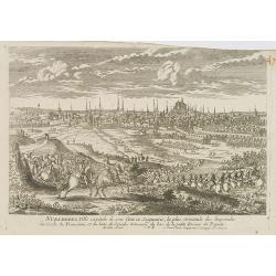
![[Breisach] Profil de la ville de Brisac scituée sur le Rhin dans le Brisgau prise par l'armée du Roy commandée par Monseign.r le duc de Bourgogne le 6.e septembre 1703.](/uploads/cache/43496-250x250.jpg)
[Breisach] Profil de la ville de Brisac scituée sur le Rhin dans le Brisgau prise par l'armée du Roy commandée par Monseign.r le duc de Bourgogne le 6.e septembre 1703.
Scene of the siege of Breisach in 1703 by Marshal Tallard during the Spanish Succession War.
- $120 / ≈ €105
Date: Paris, 1703
L'Allemagne divisée en dix cercles . . .
An interesting small map of Germany and Poland by Nicolas de Fer. From his rare "Petit et Nouveau Atlas". The first edition was published in 1697 and was republ...
Date: Paris, 1704
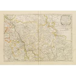
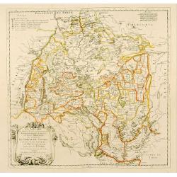
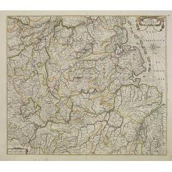
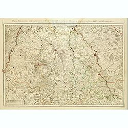
Le cercle de la Basse Saxe subdivisé en touts les estats et principautés qui le composant . . .
It is a very large map centered on the river Elbe and following the coastlines of the Baltic Sea up to the Polish border. The map is fully and richly engraved. Large and ...
- $200 / ≈ €175
Date: Amsterdam, c.1705
Partie Méridionale de l'Archevesché et Eslectorat de Cologne. . .
Fine map of the Westphalia, the area in-between the Rivers Maas and Rhine.
- $50 / ≈ €44
Date: Paris, 1707
Principatus Isenacensis cum adjacentibus. . .
Detailed map centered on Gotha and Erfurt. Lower right splendid title cartouche.The map is painted in strong colors. Clearly from an show-piece atlas produced for a wealt...
- $200 / ≈ €175
Date: Nurenberg, 1710
Geographica descriptio Montani cujusdam districtus in ..
Detailed map including the towns of Thurnau, Bayreuth, Culmbach, etc. With fine panoramic view of Thurnau. Upper left and right splendid title cartouches.The map is paint...
Date: Nurenberg, 1710
(Ochfenfurt, Hall, Bavaria, etc.)
Rare miniature map of Bavaria including the towns of Ochfenfurt, Hall, etc. From "Le theatre De Bellone, Contenant 48. nouvelles Cartes Geographiques, Des Païs-Bas ...
- $60 / ≈ €52
Date: Amsterdam, 1710
(Hildesheim, Munden, Steinbrugge, Grubenhagen, etc.)
Rare miniature map including the towns of Hildesheim, Munden, Steinbrugge, Grubenhagen, etc. From "Le theatre De Bellone, Contenant 48. nouvelles Cartes Geographique...
- $60 / ≈ €52
Date: Amsterdam, 1710
(Schweinfurt, Reineck, Hirschfeld, etc.)
Rare miniature map including the towns of Schweinfurt, Reineck, Hirschfeld, etc. From "Le theatre De Bellone, Contenant 48. nouvelles Cartes Geographiques, Des Païs...
- $60 / ≈ €52
Date: Amsterdam, 1710
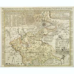
Accurate geographische delineation der in dem Meisnichen creisse des chufurstenthums sachsen liegenden dioeces oder des ammtes grossen hayn
Very detailed map prepared by Adam Frederic Zürner (1680-1742). Surrounded with legends and decorated in the lower right corner with a plan of a royal campement. The tow...
- $90 / ≈ €79
Date: Amsterdam, 1711
Le Duche de Lunebourg. . .
A lovely, detailed map by Pierre Van der AA of the northern German region of Luneburg in Lower Saxony, roughly situated between the Elber and the Aller Rivers. Luneburg i...
Date: Leiden, 1713
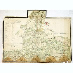
Carte du cours du Rhin dpuis le fort de Schengen jusqu'à Lauterbourg. . .
Beautiful manuscript map of the region around Rastatt and the siege of 1714 signed with the French emperor Charles VI of Habsburg. In top with a small extension of the ma...
Date: Germany, France, c. 1714
L'Empire D'Allemagne Divisé en ses dix Cercles et Autres Estats..
Map centered on Germany, including Switzerland, Austria, part of France, Northern Italy and Eastern Europe. With title cartouche and a panel in the lower left corner list...
- $60 / ≈ €52
Date: Paris 1719
L'Empire D'Allemagne Divisé en ses dix Cercles et Autres Estats. . .
Map centered on Germany, including Poland, Switzerland, Austria, part of France, Northern Italy and Eastern Europe. With title cartouche and a panel in the lower left cor...
- $80 / ≈ €70
Date: Paris, 1719
Nova et accurata Territorii Ulmensis cum dominio Wainensi..
"Showing the area of Ulm. In the lower part, an inset map of the property"zu Wein". Upper right splendid title cartouche.The map is painted in an intense a...
Date: Nurenberg 1720
Saxoniae Superioris
Impressive title cartouche with miniature panoramic view of Leipzig, coat of arms, putti and Mercury.Johann Baptist Homann born in Kammlach (1663). He was engraver, map-s...
- $150 / ≈ €131
Date: Augsburg, 1720
![Mayence Mentz en allemand .. [Metz]](/uploads/cache/13109-250x250.jpg)
Mayence Mentz en allemand .. [Metz]
A very RARE panoramic view of the city of Metz, including a numbered legend in the lower corners. The plate is numbered in red pencil in the upper right corner.Engraved b...
- $200 / ≈ €175
Date: Paris 1690-1720
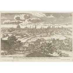
Nuremberg.
A very RARE panoramic view of the city of Nuremberg. The plate is numbered in red pencil in the upper right corner.Engraved by Pierre Aveline (Paris, c.1656 - 23 May 1722...
- $200 / ≈ €175
Date: Paris, 1690-1720
Ausbourg Ville Impériale d'Allemagne dans la Suabe.
A very RARE panoramic of the city of Augsburg. The plate is numbered in red pencil in the upper right corner.Engraved by Pierre Aveline (Paris, c.1656 - 23 May 1722). He ...
- $250 / ≈ €218
Date: Paris, 1690-1720
Treves en Allemend Trier.
A very RARE panoramic view of the city of Trier. The plate is numbered in red pencil in the upper right corner.Engraved by Pierre Aveline (Paris, c.1656 - 23 May 1722). H...
- $200 / ≈ €175
Date: Paris, 1690-1720
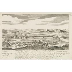
Philisbourg.
A very RARE panoramic view of the city of Philipsburg, including a numbered legend in both lower corners. The plate is numbered in black pencil in the upper right corner....
- $150 / ≈ €131
Date: Paris c.1720
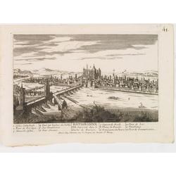
Ratisbonne.
A very RARE panoramic town view of the city of Ratisbonne, including a numbered legend in both lower corners. The plate is numbered in black pencil in the upper right cor...
- $200 / ≈ €175
Date: Paris c.1720
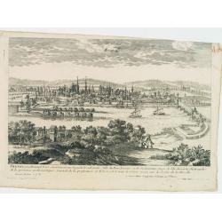
Breme.
A rare panoramic view of the city of Bremen, including a numbered legend in both lower corners.Published by the brothers Chéreau, active in Paris at rue st.Jacques au Gr...
- $200 / ≈ €175
Date: Paris c.1720
Nassovia Principatus Cum omnibus ei pertinentibus Comitatibus Dominiis ac Praefecturis ut et Confiniis intra Lahnun, Rhenum, et Moenum Flumina, ad situm verum exacte delineatus a Joh. Jac. Stetter. U.J.L. Idstenio-Nassovio . . .
Decorative map of the area between the rivers Rhine and Meuse, including Mainz, Koblenz, Frankfurt, Saarbrucken, etc.Includes an elaborate cartouche and coat of arms.The ...
- $150 / ≈ €131
Date: Amsterdam, 1720
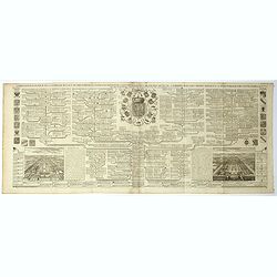
Carte genealogique de la famille Royale de Brunswick . .
A very detailed composite sheet with a genealogical table of the German royal families of Brunswick, Luneburg and Hanover, with descriptive French textZacharie Chatelain ...
- $50 / ≈ €44
Date: Amsterdam, ca. 1720
Le Duché de Lunebourg, suivant les nouvelles observations?
Uncommon edition of this map of a province of Germany. With decorative title cartouche upper right corner.This example is unusual in having the additional separately engr...
- $80 / ≈ €70
Date: Amsterdam, 1728
Cercle de la Basse Saxe, suivant les nouvelles observations..
Uncommon edition of this map of a province of Germany, including Hamburg, Bremen, etc. With decorative title cartouche lower right corner.This example is unusual in havin...
- $90 / ≈ €79
Date: Amsterdam 1728
La Souabe meridionale, suivant les nouvelles observations..
Uncommon edition of this map of Southern Germany. With decorative title cartouche lower right corner.This example is unusual in having the additional separately engraved ...
- $90 / ≈ €79
Date: Amsterdam 1728
L'Archeveché de Mayence, suivant les nouvelles observations..
With decorative title cartouche lower left corner. Including river Rhine. This example is unusual in having the additional separately engraved decorative framework border...
- $100 / ≈ €87
Date: Amsterdam, 1728
Landgraviat de Hesse, suivant les nouvelles observations..
With decorative title cartouche lower right corner.This example is unusual in having the additional separately engraved decorative framework border around the map, the re...
- $90 / ≈ €79
Date: Amsterdam 1728
Nova et Accurata Ducatus Cliviae et Comitatus Marchiae.
With an elaborate -uncolored- title cartouche.
Date: Augsburg, 1728
