-250x250.jpg)
La descrittione di Belgica con le sve frontiere (maps of the Seventeen Provinces)
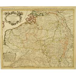
La descrittione di Belgica con le sve frontiere Omnis Belgica intra Rhenum, marronam, Sequana[m] ac Oceanum, ... This is one of the earliest printed maps of the Sev...
Date: Antwerp, 1567
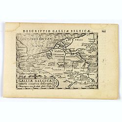
Descriptio Galliae Belgicae.
A decorative miniature map of a section of ancient France, and that of Belgium. Features a nice strap-work title, shows rivers and settlements. From the Bertius atlas Tab...
- $100 / ≈ €87
Date: Amsterdam, 1606
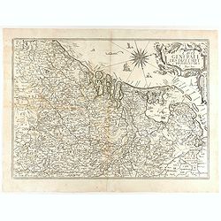
Carte Generale des Dixet Sept Provinces des Pays Bas.
Rare map of the Low Countries, including Belgium, the Netherlands and Luxembourg after Tassin and offered for sale by the publisher N. Berey.
Date: Paris, 1634
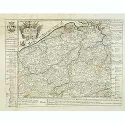
Le Comté de Flandre par P. Placide Augustin. . .
Detailed map of Flanders prepared by P. Placide Augustin, with fine title cartouche and dedication to "Monseigneur Le Marquis de Torcy, Secretaire d'État" in u...
- $350 / ≈ €306
Date: Paris, 1690
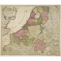
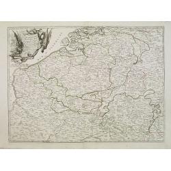
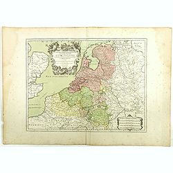
Septendecm. Provinciae Germaniae Inferior. . .
A general map of the Netherlands, Luxembourg and Belgium. Fine title cartouche showing Mercury, Neptune, globe, etc. Lower right coat of arms of 17 Provinces.
- $225 / ≈ €197
Date: Amsterdam, 1700
Carte Des Pays Bas Catholiques Dressée. . .
Topographically detailed map that extends from Paris to Metz and north into Holland. Details include roads and scores of villages. Two decorative cartouches: one with fig...
Date: Amsterdam, c. 1745
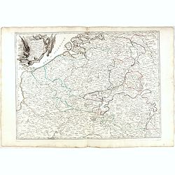
Partie meridionale des Pays Bas.. Cambrefis et Artois.
Finely and crisply engraved map of Belgium, including southern part of Netherlands and part of Germany.Venetian edition of Giles Didier Robert De Vaugondy's map from Atla...
Date: Venice, 1776 - 1784
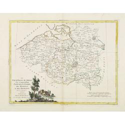
Il Paesi Bassi Austriaci, che comprendono parte delle Flandre, del Haynault, e del Brabante.
Uncommon map of Flanders and Brabant in present-day Belgium. Embellished with a nice title-cartouche. Engraved by G.Pitteri after G.Zuliani.From his Atlante Novissimo, il...
- $140 / ≈ €122
Date: Venice, 1784
Partie meridionale des Pays Bas.. Cambrefis et Artois.
Finely and crisply engraved map of Belgium, including southern part of Netherlands and part of Germany.Venetian edition of Giles Didier Robert De Vaugondy's map from Atla...
- $100 / ≈ €87
Date: Venice, 1776 - 1784
Les Dix-Sept Provinces des Pays-Bas. . .
Map of the present-day Benelux by L.C. Desnos. Engraved by Cordier.
- $100 / ≈ €87
Date: Paris, 1784
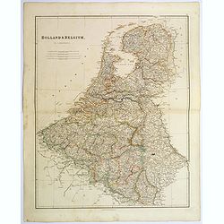
Holland & Belgium.
An attractive steel engraved map of Holland and Belgium. Map flanked by France and Prussia. Duchy of Luxembourg included. Many place names and physical features shown. 4 ...
Date: London, 1839
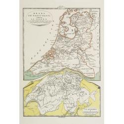
Regno de' Paesi-Bassi compresa la Olanda . . . / La Svizzera . . .
Two rare and detailed maps of The Netherland (210 x 230mm. ) and Switzerland (140 x 230mm.) According to the title cartouche, prepared by J.A.Buchon and A de La Sage for ...
Date: Venice, 1840
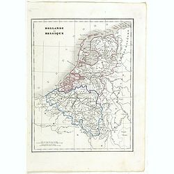
Hollande et Belgique.
Detailed Holland and Belgium map, prepared by Charles V. Monin (fl.1830-1880) a French cartographer of Caen and Paris. Published in ''Atlas Universel de Géographie Ancie...
- $50 / ≈ €44
Date: Paris, 1845
![[Goose game board] Le 1914 Edition pochette.](/uploads/cache/47215-250x250.jpg)
[Goose game board] Le 1914 Edition pochette.
Goose game in the form of a folding map of north of France and Belgium, with part of England, Germany, Holland and Luxembourg.
- $450 / ≈ €393
Date: Paris, 1914
