Browse Listings in Atlases
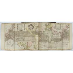
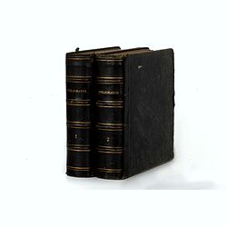
Atlas van Zeevaert en Koophandel door de Geheele Weereldt.
Engraved frontispiece, title printed in red and black with engraved vignette, engraved dedication to the Dutch East India Company, 32 double-page engraved charts with con...
- $65000 / ≈ €60822
Place & Date: Amsterdam, 1745
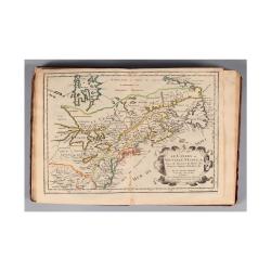
L'Amerique, en plusieurs cartes nouvelles, et exactes, &c. En divers traitez de geographie, et d'histoire. Là où sont descrits succinctement, & avec une belle Methode, & facile.
Third edition, the text and maps of which are identical to the first given in 1657. However, the dedication to Nicolas Fouquet (2 pp.), disgraced in 1661, has been delete...
- $4500 / ≈ €4211
Place & Date: Paris, 1680
Korte geographische oefeningen voor het eerste onderwijs in de kennis der geheele aarde
Ilustrated with World Map, map of Europe, the Netherlands, Asia, Africa, North America, South America and Australia.Provenance : J.de Veth, October 1845.
- $400 / ≈ €374
Place & Date: Zaltbommel, 1843
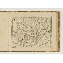
Himmels Atlas in 20 Blättzen nach den grossen Bodenschen Sernkarten…
Schreibers Erben, 1849. Publisher's binding with minor rubbing and wear to boards. Corners showing and some chipping at head of spine. 8 text pages and 20 engraved plates...
- $300 / ≈ €281
Place & Date: Leipzig, Schreibers Erben, 1849
![Almanach Géograhique ou petit atlas.. [Seconde partie]](/uploads/cache/48945-250x250.jpg)
Almanach Géograhique ou petit atlas.. [Seconde partie]
The second part of this uncommon miniature atlas with extensive geographical descriptions of mainly European countries.Including map of France; Netherlands; Belgium; Spai...
- $700 / ≈ €655
Place & Date: Paris, 1770

Etrennes Géographiques.
The leather binding has light wear and slight damage to the spine. The maps have very good impressions. Age-toning, occasional spotting, and soiling throughout. The margi...
- $450 / ≈ €421
Place & Date: Paris, 1761
Petites tables Geneologiques touchant les droits et les interests des Princes.
Compilation of Duval's Pocket Atlas, with an archbishoprics and dioceses description of the world, here right at the beginning with the rare genealogical tables of variou...
- $3000 / ≈ €2807
Place & Date: Paris, P. Duval, ca. 1667-1672
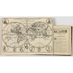
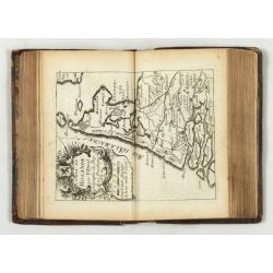
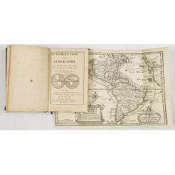
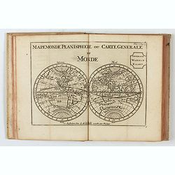
Introduction a la Geographie..
Second edition of this charming travel compendium illustrated with a fine world map in two hemispheres prepared by de l'Isle. California as an island. The hemispheres are...
- $2000 / ≈ €1871
Place & Date: Paris, 1717
Almanach Géograhique ou petit atlas..
Uncommon miniature atlas with extensive geographical descriptions of mainly European countries.Including a map of the eastern hemisphere, with a curious outline for Austr...
- $1500 / ≈ €1404
Place & Date: Paris, 1770
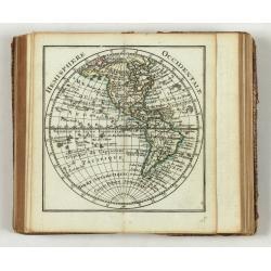
Introduction a la Geographie
Engraved title, with 91 double-page engraved maps mostly including European nations, but including World and continents, Turkey, the Holy Land, Persia, China, Japan, Egyp...
- $3000 / ≈ €2807
Place & Date: Paris, 1756
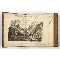
Le Petit atlas maritime. Recueil de cartes et plans des quatre parties du monde, en cinq volumes.
FIRST EDITION. A large paper copy, in attrictive original colors. Jacques Nicolas Bellin held offical status as royal hydrographer and ingéniuer géographe de la marine ...
- $45000 / ≈ €42107
Place & Date: Paris, 1764
Étrennes intéressantes des quatre parties du monde et des troupes de France Année MDCC LXXXXI Dix-septième Règne de Louis XVI restaurateur de la liberté française.
The almanac consists of an old-style calendar, eclipses, signs of the zodiac, and an abbreviated table of the different parts of the world. It is illustrated with folding...
- $900 / ≈ €842
Place & Date: Paris, 1791
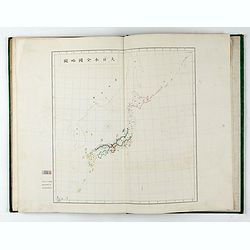
内務省地理局 (Administratif atlas of the Empire of Japan.)
Atlas of Japan published by the Home Ministry shortly after the start of Meiji period. The atlas contains 16 double page maps, with the border in original out line colors...
- $550 / ≈ €515
Place & Date: Tokyo, Meiji 14 or 1881

Voyage de découvertes aux Terres Australes. Historique. Atlas Deuxième partie.
First edition of the second part of the atlas by Freycinet, part of his important book "Voyage de découvertes aux Terres Australes". Illustrated with two foldi...
- $7500 / ≈ €7018
Place & Date: Paris, Langlois, 1811
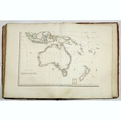
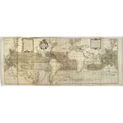
Grand atlas universel ou collection de cartes encyprotypes, générales et détaillées des cinq parties du monde.
Large folio atlas containing 8 general one-sheet maps, and 8 detailed four-sheet maps: Containing2 World maps- "Mappe-monde sur la projection de Mercator. Carte ency...
- $6000 / ≈ €5614
Place & Date: Paris, Desray, 1816
Bibliomappe. Chronologie Historique et Géographique par MM. Année et Vivien bound with : Bibliomappe, ou Livre-Cartes: Leçons Méthodiques de Chronologie et de Géographie, . . .
With 67 maps (1 folding) by A.M. Perrot. Published in Paris. Most maps have original color. The atlas is complete very rare, as it was issued in 15 separate installments ...
- $1750 / ≈ €1638
Place & Date: Paris, Renard, 1827 / 1824-1826
Histoire universelle depuis le commmencement du monde jusqu'a present. Tome Vingt-unieme. Portugais, Espagnols, Hollanois etc
Volume 21 of this informative publication with a description of the discoveries, conquests, and settlements by the Portuguese, Spaniards, English, and Dutch in Southeast ...
- $1500 / ≈ €1404
Place & Date: Amsterdam, Leipzig, 1763
Atlas van Zeevaert en Koophandel door de Geheele Weereldt.
Engraved frontispiece, title printed in red and black with engraved vignette, engraved dedication to the Dutch East India Company, 32 double-page engraved charts in very ...
- $50000 / ≈ €46786
Place & Date: Amsterdam, 1745
Der curiose und ... Nüssliche Dollmetscher..
Rare atlas and containing geographical descriptions of all continents. Illustrated with 30 very finely engraved and beautifully colored maps in attractive original strong...
- $6000 / ≈ €5614
Place & Date: Augsburg, 1748
![Boertige reis door Europa. . . [with] Europa volgens de nieuwste verdeeling. . .](/uploads/cache/32642-250x250.jpg)
Boertige reis door Europa. . . [with] Europa volgens de nieuwste verdeeling. . .
Rare illustrated publication including a rare map of Europe as a regal queen with the title "Geheimzinnige toebereidselen tot eene boertige reis door Europa. [...] v...
- $2000 / ≈ €1871
Place & Date: Haarlem, 1794
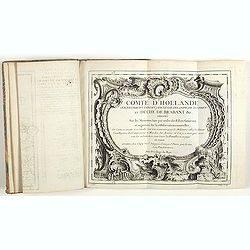
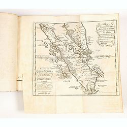
Comté d'Hollande, seigneurie d'Utrecht, comtés de Zelande, de Zutphen et duché de Brabant &c. Dressés sur les Mémoires faits par ordre des Estats Généraux et augmentés sur les Observations nouvelles.
Pocket atlas illustrated with a folded engraved title, a general map and 34 folded maps, including maps of the Netherlands, Belgium and parts of Germany.Provenance : Ex-l...
- $2400 / ≈ €2246
Place & Date: Paris, Crépy, ca. 1748
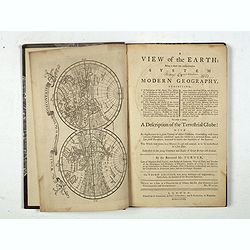
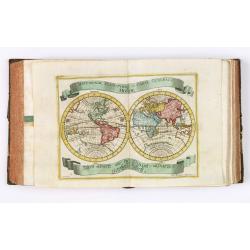
A view of the earth : being a short but comprehensive system of modern geography graphy ...
The Third Edition. First work with seven engraved maps (including a twin-hemisphere world map, continents), plate of a globe, engraved illustrations in the text including...
- $1750 / ≈ €1638
Place & Date: London, S. Crowder and S. Gamidge, 1771
Atlas Minor praecipua Orbis Terrarum Imperia, Regna et Provincias Germinae Potissimum, tabellis 50 exacte delineatis fiftens usui militiae ducum ac peregrinantium maxime accommodatus opera.
This collection of highly attractive maps were drawn by Georg Matheus Seutter and his son Albrecht Carl. Georg Matheus was one of the most important German Cartographers ...
- $5250 / ≈ €4913
Place & Date: Augsburg, 1744
DESCRIPTION DE TOUT LE PAIS BAS Autrement dict La Germanie Inferieure, ou Basse-Allemaigne…
First French edition. Illustrated with a coat of arms and portrait of Philips II, with a folding map of The Netherlands and maps and views of Brabant, Louvain, Brussel, A...
- $4500 / ≈ €4211
Place & Date: Anvers. Guillaume Silvius, 1567
Introduction a la Geographie..
Second edition of this charming travel compendium illustrated with a fine world map in two hemispheres prepared by de l'Isle. California as an island. The hemispheres are...
- $2000 / ≈ €1871
Place & Date: Paris, 1717
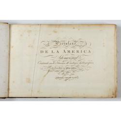
Portulano de la Ameririca Setentrional construido en la direccion de tabajos.
The Portulano de la America Setentrional, is an exceedingly rare Spanish sea atlas featuring charts of the Caribbean and the Gulf of Mexico. It was developed by the astr...
- $45000 / ≈ €42107
Place & Date: Madrid, 1818

Le Nouveau miroir des voiages marins de la navigation de la mer occidentale & orientale.
A second and final French edition of this important sea atlas. Two engraved frontispieces, figure with volvelle, full-page figure, 48 double-page charts (one numbered 19....
- $120000 / ≈ €112286
Place & Date: Antwerp, Chez Iean Bellere, a l’Aigle d’or, l’An M.CCCCCC (1600
Geographisches-Toneel, Of uitgezochte kaarten, Tot gemak der Officieren, Reisigers en Liefhebbers.
Pocket atlas, not in Koeman, but similar to Koeman III, p. 99 (Rat 1) of which our atlas is a later edition.Illustrated with 41 engraved maps, of which two are in origina...
- $2000 / ≈ €1871
Place & Date: Amsterdam, D. Weege, 1653
![Description de tovts les Pays-Bas, autrement appellez, la Germanie Inferieure, ov Basse Allemagne / par Messire Loys Gvicciardin [...]](/uploads/cache/48781-250x250.jpg)
Description de tovts les Pays-Bas, autrement appellez, la Germanie Inferieure, ov Basse Allemagne / par Messire Loys Gvicciardin [...]
Fine early edition of the French oblong edition of this famous description of the Low Countries. For the French edition most plates are newly engraved by Petrus Kaerius.....
- $3500 / ≈ €3275
Place & Date: Arnhem, Janssonius, J.,1613

Neptune des Côtes Occidentales de France.
Large maritime atlas illustrated with a handwritten title, a table and 47 single or double page charts. The charts show the western coasts of France as well as the Spanis...
- $12000 / ≈ €11229
Place & Date: Paris, 1776-1822
![The Cerographic Missionary Atlas. [Imprint inside front cover:] Entered according to Act of Congress, in the year 1848, By Se. E. Morse & Co.,....](/uploads/cache/41699-250x250.jpg)
The Cerographic Missionary Atlas. [Imprint inside front cover:] Entered according to Act of Congress, in the year 1848, By Se. E. Morse & Co.,....
An unusually and quite early American atlas of areas where missionary activity was being, or could be conducted. Including two global hemispheres showing North and South ...
- $1250 / ≈ €1170
Place & Date: New York, 1848
Atlas des Missions Catholiques.
Vingt cartes teintées, avec texte explicatif par R. P. O. Werner de la Compagnie de Jésus. Traduit de l’Allemand, revu et augmenté par M. Valérien Groffier, auteur ...
- $1000 / ≈ €936
Place & Date: Lyon, 1886
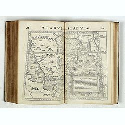
Strabonis nobilissimi et doctissimi philosophi ac geographi Rervm geographicarum commentarij libris XVII contenti, Latini facti Gvilielmo Xylandro Augustano interprete. . .
A few marginal annotations (pp. 109-111), in a 19th c. hand. Latin translation with a commentary by Wilhelm Holtzmann, also called Guglielmus Xylander. (1532-1576), libra...
- $15000 / ≈ €14036
Place & Date: Basle, Henri Petri, 1571
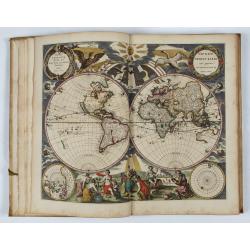
L’Atlas de la Mer ou Monde aquaticque.
Original blind-stamped vellum binding ; attractive ORIGINAL HAND-COLOR in outline with cartouches, windroses and decoration in full orginal color ; internally some usual ...
- $75000 / ≈ €70179
Place & Date: Amsterdam, sur le Cay de Teexel, prez du Rams-Koy, au miroir de la Mer, 1670
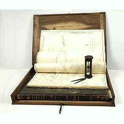
J.Horsburgh/ R.H.Bate / G.H.Stapleton. The two chart books are bound in contemp. half calf, and include together 57 of the most up-to-date French (Depot général de la marine) and English (Hydrographic Office) charts available in 1847 for sailing t
BOOK 1 : Mainly charts by "Dépôt Général de la Marine" including 20 folding charts. The binding measuring 665x275mm, the charts mostly 595x910mm.1. Dépôt ...
- $50000 / ≈ €46786
Place & Date: Paris, London, Hong Kong, 1835 - 1849
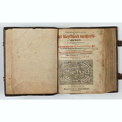
Itinerarium Sacrae Scripturae, dat is, Het Reysboeck der heyligher Schrift
This is a scarce 1648 Dutch edition of Büntings "Itinerarium Sacrae Scripturae" printed in Leeuwarden. The book includes 6 folding maps and 2 plates. The book ...
- $3000 / ≈ €2807
Place & Date: Leeuwarden, de Vries, Jan Jansz., 1648
![[Atlas] Images du Monde. Atlas Illustré.](/uploads/cache/44610-250x250.jpg)
[Atlas] Images du Monde. Atlas Illustré.
In original green publishers green covered cloth covers, complete with a contents table and 33 pictorial maps of countries of the world (including continents and a world ...
- $200 / ≈ €187
Place & Date: Paris, 1942
![[12 volumes] Recueil des voyages qui ont servi à l'établissement et aux progrez de la Compagnie des Indes Orientales, forméedans les Provinces-Unies des Païs-Bas...](/uploads/cache/43700-250x250.jpg)
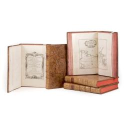
[12 volumes] Recueil des voyages qui ont servi à l'établissement et aux progrez de la Compagnie des Indes Orientales, forméedans les Provinces-Unies des Païs-Bas...
An important richly illustrated compendium of the first Dutch voyages to East India, of great interest for the history and establisment of the Dutch global trade, particu...
- $5000 / ≈ €4679
Place & Date: Rouen, Pierre Le Boucher, 1725
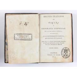
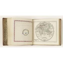
Breves tratados de esfera y geografía universal, con algunas noticias históricas, en especial en lo perteneciente a España, para instruccion de la juventud.
Third edition of this popular Spanish Atlas for children, illustrated with 6 folding engraved "blind" maps, all finely colored by hand, in the main part in orig...
- $750 / ≈ €702
Place & Date: Madrid, Impreta de Collado, 1814
Etrennes interessantes des quartre parties du monde..
A charming almanac for the year 1778. The maps are engraved by Durand et Le Roy, and each map has the name of the author Giovanni Antonio Battista Rizzi-Zannoni. This cha...
- $2500 / ≈ €2339
Place & Date: Paris, 1760