Browse Listings in Atlases
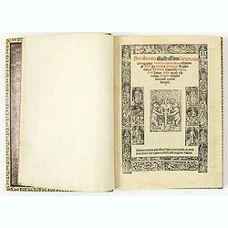
Strabonis illustrissimi scriptoris Geographia decem et septem libros continens.
First edition was published in Paris in the sixteenth century and the first with the preface by Thibaud Pigenat. Translation from Greek into Latin by Gregorio Tifernate a...
- $5000 / ≈ €4368
Date: Paris, Hémon Le Fèvre, 1512
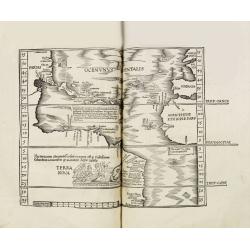
Claudii Ptolemaei geographicae enarrationis libri octo Bilibaldo Pirckeym hero interprete Annotationes Ioannis de Regio Monte in errores commissos a Iacobo Angelo in translatione sua.
This is a rare and interesting edition of Ptolemy's geography translated by Bilibaldo Pirckheym, accompanied by Regiomantus's annotations, and said to have been edited by...
- $59000 / ≈ €51540
Date: Strassburg, Johann Grüninger, Johann Koberger, 1525
DESCRIPTION DE TOUT LE PAIS BAS Autrement dict La Germanie Inferieure, ou Basse-Allemaigne…
First French edition. Illustrated with a coat of arms and portrait of Philips II, with a folding map of The Netherlands and maps and views of Brabant, Louvain, Brussel, A...
- $4500 / ≈ €3931
Date: Anvers. Guillaume Silvius, 1567
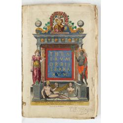
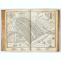
Theatrum Orbis Terrarum.
A Dutch edition of Ortelius' Theatrum Orbis Terrarum "Ghedruckt voor A. Ortelius" (by Corn. Claesz.?), 1598. Illustrated with 92 maps, 91 maps numbered 1-91, in...
- $100000 / ≈ €87355
Date: (Amsterdam, Corn. Claesz.) ?, 1598
![Description de tovts les Pays-Bas, autrement appellez, la Germanie Inferieure, ov Basse Allemagne / par Messire Loys Gvicciardin [...]](/uploads/cache/48781-250x250.jpg)
Description de tovts les Pays-Bas, autrement appellez, la Germanie Inferieure, ov Basse Allemagne / par Messire Loys Gvicciardin [...]
Fine early edition of the French oblong edition of this famous description of the Low Countries. For the French edition most plates are newly engraved by Petrus Kaerius.....
- $3500 / ≈ €3057
Date: Arnhem, Janssonius, J.,1613
!['T Derde deel van 't Licht der zee-vaert, inhoudende de beschryvinghe der zeecusten van de Middelandtsche Zee /, By een vergaedert ende in't licht ghebracht door Willem Janssen. [Blaeu sea atlas].](/uploads/cache/49048-250x250.jpg)
'T Derde deel van 't Licht der zee-vaert, inhoudende de beschryvinghe der zeecusten van de Middelandtsche Zee /, By een vergaedert ende in't licht ghebracht door Willem Janssen. [Blaeu sea atlas].
Extremely rare W. Blaeu's Sea Atlas describing the coasts and islands of the Mediterranean Sea, published in Amsterdam by W. Blaeu" Tot Amsterdam, by Willem Jansz. ...
- $150000 / ≈ €131033
Date: Amsterdam, 1618

Composite atlas of the Low Countries.
A unique, made-to-order atlas comprising 18 double-page engraved maps by or after Hessel Gerritsz, Theodoor Galle, Jacob van Deventer, Gerard Mercator, Peter Verbiest, Je...
Date: [Antwerp, c. 1633
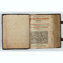
Itinerarium Sacrae Scripturae, dat is, Het Reysboeck der heyligher Schrift
This is a scarce 1648 Dutch edition of Büntings "Itinerarium Sacrae Scripturae" printed in Leeuwarden. The book includes 6 folding maps and 2 plates. The book ...
- $3000 / ≈ €2621
Date: Leeuwarden, de Vries, Jan Jansz., 1648

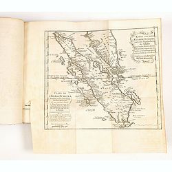
Chorographica descriptio provinciarum, et conventum fratrum minorum S. Francisci Capucinorum...
All maps are good and dark impressions. Several maps with slight foxing and browning, the folding map with 2 splits (top right part 10 cm and lower left part 6 cm into en...
Date: Turin, 1649
Geographisches-Toneel, Of uitgezochte kaarten, Tot gemak der Officieren, Reisigers en Liefhebbers.
Pocket atlas, not in Koeman, but similar to Koeman III, p. 99 (Rat 1) of which our atlas is a later edition.Illustrated with 41 engraved maps, of which two are in origina...
- $2000 / ≈ €1747
Date: Amsterdam, D. Weege, 1653
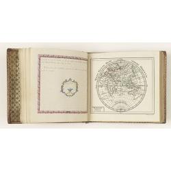
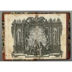
Petites tables Geneologiques touchant les droits et les interests des Princes.
Compilation of Duval's Pocket Atlas, with an archbishoprics and dioceses description of the world, here right at the beginning with the rare genealogical tables of variou...
- $3000 / ≈ €2621
Date: Paris, P. Duval, ca. 1667-1672
Introductio in universam geographiam tam veterem, quám novam... et tabulis geographicis aucta studio & operâ Johannis Bunonis. . .
Engraved title with minor ink dash, title with former owner's signatures Joannes Steuchig, (could be the Swedish archbishop Johannes Steuchius (1676-1742). D. Hildebrand ...
- $3000 / ≈ €2621
Date: Amsterdam, 1676
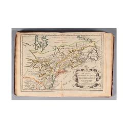
L'Amerique, en plusieurs cartes nouvelles, et exactes, &c. En divers traitez de geographie, et d'histoire. Là où sont descrits succinctement, & avec une belle Methode, & facile.
Third edition, the text and maps of which are identical to the first given in 1657. However, the dedication to Nicolas Fouquet (2 pp.), disgraced in 1661, has been delete...
- $4500 / ≈ €3931
Date: Paris, 1680
Atlas nouveau contenant toutes les parties du monde, ou sont exactement remarqués les empires, monarchies, royaumes, estats, republiques & peuples qui s y trouvent & present..
Very fine example in atractive original colors of the second edition of this atlas by Pieter Mortier. The publisher of Amsterdam Mortier lived in Paris between 1681 and 1...
- $75000 / ≈ €65516
Date: Amsterdam c. 1696
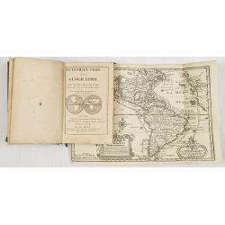
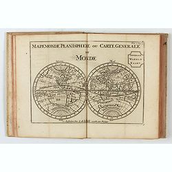
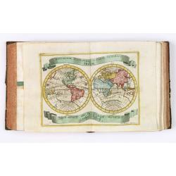
Introduction a la Geographie..
Second edition of this charming travel compendium illustrated with a fine world map in two hemispheres prepared by de l'Isle. California as an island. The hemispheres are...
- $2000 / ≈ €1747
Date: Paris, 1717
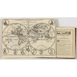
Introduction a la Geographie..
Second edition of this charming travel compendium illustrated with a fine world map in two hemispheres prepared by de l'Isle. California as an island. The hemispheres are...
- $2000 / ≈ €1747
Date: Paris, 1717
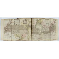
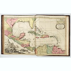
Atlas van Zeevaert en Koophandel door de Geheele Weereldt.
Engraved frontispiece, title printed in red and black with engraved vignette, engraved dedication to the Dutch East India Company, 32 double-page engraved charts with con...
- $65000 / ≈ €56781
Date: Amsterdam, 1745

Le Théâtre du monde dédié au roi contenant les cartes générales et particulières des royaumes et états qui le composent.
The present example of the Théâtre du monde is the reissue of 1746 by Jean-Baptiste Nolin II. This scarce atlas is illustrated with 123 maps mostly double-page, in orig...
Date: Paris, 1746
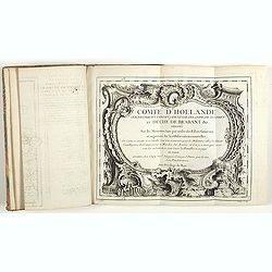
Comté d'Hollande, seigneurie d'Utrecht, comtés de Zelande, de Zutphen et duché de Brabant &c. Dressés sur les Mémoires faits par ordre des Estats Généraux et augmentés sur les Observations nouvelles.
Pocket atlas illustrated with a folded engraved title, a general map and 34 folded maps, including maps of the Netherlands, Belgium and parts of Germany.Provenance : Ex-l...
- $2400 / ≈ €2097
Date: Paris, Crépy, ca. 1748
Der curiose und ... Nüssliche Dollmetscher..
Rare atlas and containing geographical descriptions of all continents. Illustrated with 30 very finely engraved and beautifully colored maps in attractive original strong...
- $6000 / ≈ €5241
Date: Augsburg, 1748
Etrennes interessantes des quartre parties du monde..
A charming almanac for the year 1778. The maps are engraved by Durand et Le Roy, and each map has the name of the author Giovanni Antonio Battista Rizzi-Zannoni. This cha...
- $2500 / ≈ €2184
Date: Paris, 1760
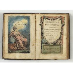
Etrennes Géographiques.
The leather binding has light wear and slight damage to the spine. The maps have very good impressions. Age-toning, occasional spotting, and soiling throughout. The margi...
- $450 / ≈ €393
Date: Paris, 1761
Atlas Geographicus portatilis XXIX mappis orbis habitabilis
Fine pocket atlas containing a world and celestial map, further maps of the four continents and of European countries. The map of America has a blank coastline north to C...
- $2750 / ≈ €2402
Date: Augsburg 1762
Histoire universelle depuis le commmencement du monde jusqu'a present. Tome Vingt-unieme. Portugais, Espagnols, Hollanois etc
Volume 21 of this informative publication with a description of the discoveries, conquests, and settlements by the Portuguese, Spaniards, English, and Dutch in Southeast ...
- $1200 / ≈ €1048
Date: Amsterdam, Leipzig, 1763
Le Petit atlas maritime. Recueil de cartes et plans des quatre parties du monde, en cinq volumes.
FIRST EDITION. A large paper copy, in attractive original colors. Jacques Nicolas Bellin held offical status as royal hydrographer and ingéniuer géographe de la marine ...
- $45000 / ≈ €39310
Date: Paris, 1764
Almanach géographique ou petit atlas élémentaire composé de Cartes générales et particulières des différens Empires, Royaumes et Républiques de l'Europe. . .
Charming almanac with two engraved dedication and title page, portrait of Christian VII. Roy de Dannemarck et de Norvège.The map of Asia is of interest for the use of Ko...
- $3000 / ≈ €2621
Date: Paris, 1770
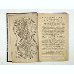
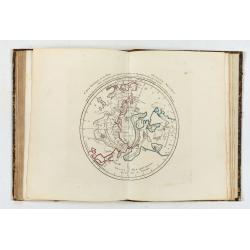
A view of the earth : being a short but comprehensive system of modern geography graphy ...
The Third Edition. First work with seven engraved maps (including a twin-hemisphere world map, continents), plate of a globe, engraved illustrations in the text including...
Date: London, S. Crowder and S. Gamidge, 1771
Atlas general A L'Usage Des Colleges Et Maisons..
Rare atlas, published by Mondhare, maps dated 1780,1781 and 1793. Usually bright, attractive copy for a work of this kind. As announced in its title, this work was specif...
- $6000 / ≈ €5241
Date: Paris, 1791
![Boertige reis door Europa. . . [with] Europa volgens de nieuwste verdeeling. . .](/uploads/cache/32642-250x250.jpg)
Boertige reis door Europa. . . [with] Europa volgens de nieuwste verdeeling. . .
Rare illustrated publication including a rare map of Europe as a regal queen with the title "Geheimzinnige toebereidselen tot eene boertige reis door Europa. [...] v...
- $2000 / ≈ €1747
Date: Haarlem, 1794
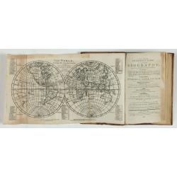
A new and easy introduction to universal geography: In a series of letters to a youth at school. . . The ninth edition, improved and considerably enlarged.
This is the interesting ninth edition, with 26 full-page maps as called for in "Directions to the binder". The ninth edition was improved and considerably enlar...
Date: London, 1800

Voyage de découvertes aux Terres Australes. Historique. Atlas Deuxième partie.
First edition of the second part of the atlas by Freycinet, part of his important book "Voyage de découvertes aux Terres Australes". Illustrated with two foldi...
- $7500 / ≈ €6552
Date: Paris, Langlois, 1811
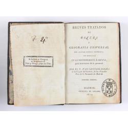
Breves tratados de esfera y geografía universal, con algunas noticias históricas, en especial en lo perteneciente a España, para instruccion de la juventud.
Third edition of this popular Spanish Atlas for children, illustrated with 6 folding engraved "blind" maps, all finely colored by hand, in the main part in orig...
- $750 / ≈ €655
Date: Madrid, Impreta de Collado, 1814

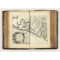
Neptune des Côtes Occidentales de France.
Large maritime atlas illustrated with a handwritten title, a table, and 47 single or double-page charts. The charts show the western coasts of France as well as the Spani...
- $12000 / ≈ €10483
Date: Paris, 1776-1822
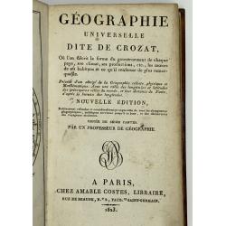
Geographie Universelle dite de Crozat.
A nice geographical dictionary with maps of the world and the continents and maps of European countries. Mappemonde, l'Europe, les provinces United des Pays Bas, Allem...
Date: Paris, 1823
![The Cerographic Missionary Atlas. [Imprint inside front cover:] Entered according to Act of Congress, in the year 1848, By Se. E. Morse & Co.,....](/uploads/cache/41699-250x250.jpg)
The Cerographic Missionary Atlas. [Imprint inside front cover:] Entered according to Act of Congress, in the year 1848, By Se. E. Morse & Co.,....
An unusually and quite early American atlas of areas where missionary activity was being, or could be conducted. Including two global hemispheres showing North and South ...
- $1250 / ≈ €1092
Date: New York, 1848
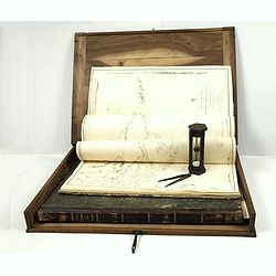
J.Horsburgh/ R.H.Bate / G.H.Stapleton. The two chart books are bound in contemp. half calf, and include together 57 of the most up-to-date French (Depot général de la marine) and English (Hydrographic Office) charts available in 1847 for sailing t
BOOK 1 : Mainly charts by "Dépôt Général de la Marine" including 20 folding charts. The binding measuring 665x275mm, the charts mostly 595x910mm.1. Dépôt ...
- $50000 / ≈ €43678
Date: Paris, London, Hong Kong, 1835 - 1849

Exposé des travaux astronomiques en Russie (Atlas) with Supplément à l’exposé des travaux astronomiques et géodésiques exécutés en Russie contenant les noms, en langue russe de toutes les positions données au chapitre V (supplément I only).
Very rare atlas published to accompany Exposé des travaux astronomiques et géodésiques exécutés en Russie dans un but géographique jusqu’à l’année 1855. St.-P...
Date: St. Petersburg, Imperial Academy of Sciences: Eggers & Co., and Leipzig, Leopold Voss, 1858
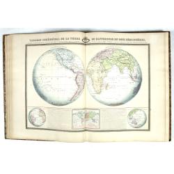
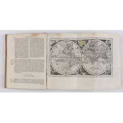
Atlas Sphéroïdal et Universel de Géographie. Dressé à l'aide des documents officiels, récemment publiés en France et à l'étranger.
World atlas divided in 6 sections : World and spheres, Europe, Asia, Africa, America and Oceania, Illustrated with 63 maps in original colors, 22 double-page maps and 41 ...
Date: Paris, Veuve Jules Renouard, 1862
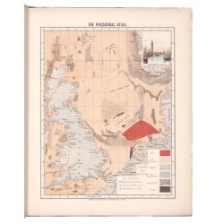
The piscatorial atlas of the North sea, English and St Georges Channels.
Olsen’s Atlas is one of the first publications on the North Sea, English and St. George’s Channels fisheries. Illustrating the fishing ports, boats, gear, species of ...
Date: Londres, Taylor et Francis, 1883
Atlas des Missions Catholiques.
Vingt cartes teintées, avec texte explicatif par R. P. O. Werner de la Compagnie de Jésus. Traduit de l’Allemand, revu et augmenté par M. Valérien Groffier, auteur ...
- $1000 / ≈ €874
Date: Lyon, 1886
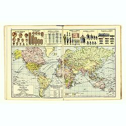
The Royal Primrose Atlas. 'A Complete Desk Companion & Blotter Combining The Most Interesting And Up-To-Date Maps ...
Contains 17 maps, an introduction plus various diagrams and statistics throughout. End pages consist of promotional material for John Knight Ltd. (Est. 1817) Manufacturer...
Date: London, ca. 1914

Geological Map of the Sydney District. / Map of the Sydney District - Geological Structure Contours.
Geological map of the Sydney district. Scale: 2 miles to 1 inch. Prepared under the direction of E.C.Andrews, Department of Mines, NSW.Although geological observations ha...
- $600 / ≈ €524
Date: Alfred James Kent, Government Printer, 1925
