Search Listings matching "ptolemy"

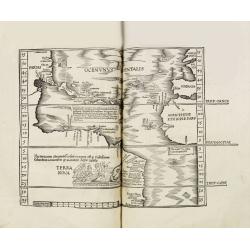
Secunda etas mundi. Folium XIII.
SCHEDEL, H. - Nuremberg, 1493 - This world map provides a window onto the late medieval imagination, published the year that Columbus returned to Europe after discovering...
Date: Nuremberg, 12 July 1493
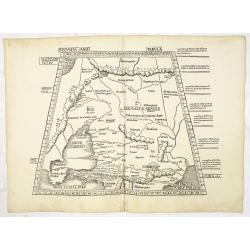
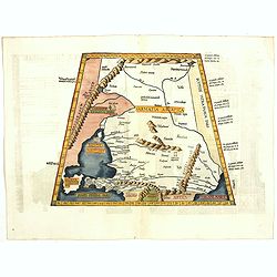
Secunda Asiae Tabula (Ukraine and Russia)
Woodblock printed a large-format Ptolemaic map showing Russia, Ukraine, and the Black Sea region. From the 1513 edition of Waldseemüller's Geographia.One of the earliest ...
Date: Strasburg, 1513

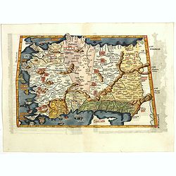
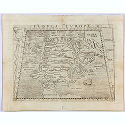
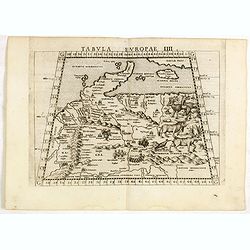
Tabula Secunda Europe (Spain & Portugal)
Wood block printed large-format Ptolemaic map of the Iberian Peninsula from the 1513 edition of Waldseemüller's Geographia.This Ptolemaic map comes from the first so call...
Date: Strasburg, 1513

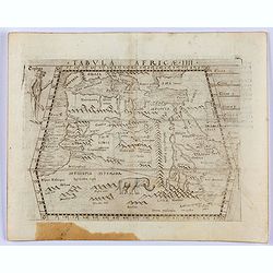
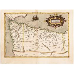
Tabula Prima Africa.
The map apart from depicting Morocco also shows southern Spain and the Balearic Islands. In north Africa the map extends eastwards toward modern day Algeria and to the we...
Date: Strasbourg, 1513

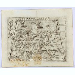
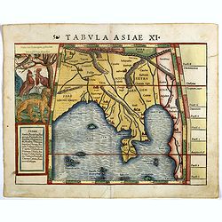
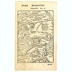
Quinta Asie Tabvla.
A woodblock map of ancient Median and Persian lands in modern-day Iran is from Martin Waldseemüller's 1513 edition of Ptolemy, a landmark work that contributed to major a...
Date: Strasbourg, J. Schott, 1513
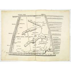
Octava Asie Tabula.
PTOLEMY, C. / WALDSEEMÜLLER, M. - The Silk Road Area.
Date: Strasburg, 1513
![Septima Asie Tabvla. |Walsseemüller's map of Central Asia and the Silk Road]](/uploads/cache/62137-250x250.jpg)
Septima Asie Tabvla. |Walsseemüller's map of Central Asia and the Silk Road]
Trapezoidal woodcut map showing the area east of the Sarygamysh Lake, about midway between the Caspian Sea and the (former) Aral Sea. It is one of the earliest obtainabl...
Date: Strasburg, J. Schott, 1513
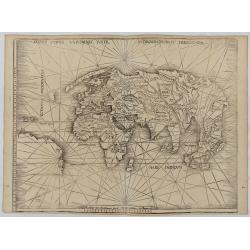
Orbis Typus Universalis Iuxta Hydrographorum Traditionem.
Waldseemüller's monumental modern map of the world from the celebrated Strassbourg edition of Ptolemy's Geography, the most important cartographer of the early sixteenth ...
Date: Strasburg, 1513 / 1520
![Claudii Ptolemaei Alexandrini mathematicor[um] ...Octo libri Geographie. . .](/uploads/cache/62656-250x250.jpg)
Claudii Ptolemaei Alexandrini mathematicor[um] ...Octo libri Geographie. . .
Third edition of "Géographie" by Ptolemy and published in Strasbourg. Illustrated with 50 maps engraved in wood. One of the more important maps shows the earlie...
Date: Strasbourg, J. Grüninger, 1522
Tabula X. Asiae hae sunt e cognitis totius orbis.
This is the earliest printed representation of India west of the Ganges River in Ptolemy's time. It is an essential map of southwestern Asia, including Persia, Afghanista...
Date: Lyons, M. Servetus, 1525
Claudii Ptolemaei geographicae enarrationis libri octo Bilibaldo Pirckeym hero interprete Annotationes Ioannis de Regio Monte in errores commissos a Iacobo Angelo in translatione sua.
This is a rare and interesting edition of Ptolemy's geography translated by Bilibaldo Pirckheym, accompanied by Regiomantus's annotations, and said to have been edited by...
- $59000 / ≈ €51582
Date: Strassburg, Johann Grüninger, Johann Koberger, 1525
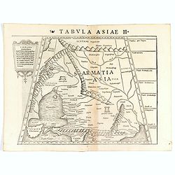
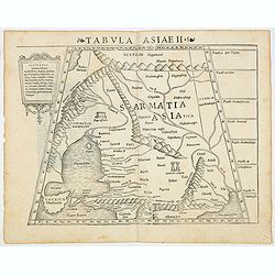
Tabula II Asiae.
A striking example of this wood-cut map depicts north of the Black Sea and west of the Caspian Sea (Ukraine, Russia, Georgia and Armenia). Ptolemy collected his data arou...
- $550 / ≈ €481
Date: Lyons, 1535

.Tabu nova partis Aphri.
This is Laurent Fries' 1535 edition of the earliest acquirable modern mapping of Africa north of the Equator.Based on Waldseemüller's map. The maps show Northern Africa a...
Date: Lyons, M. Servetus, 1535
![.Taprobana Ins. Tabula XII Asiae. [Sri Lanka.]](/uploads/cache/27928-250x250.jpg)
.Taprobana Ins. Tabula XII Asiae. [Sri Lanka.]
1535 - PTOLEMY, C. - The mythical island of Taprobana, which originally became associated with Sri Lanka.
Date: Lyons, M. Servetus, 1535
Tabula I Asiae.
Ptolemaic map of Turkey.From Lorenz Fries' edition of Ptolemy's Geographia, largely based on the 1513 map by Waldseemuller. "The elaborate Renaissance woodcut panels...
Date: Vienna, 1490, 1535
![.[Georgia (Republic), Sarmatia, Ukraine]](/uploads/cache/33870-250x250.jpg)
.[Georgia (Republic), Sarmatia, Ukraine]
Wood block printed map and one of earliest printed representation of Georgia (Republic), Sarmatia, Ukraine prepared by Martin Waldseemüller. Based on the slightly larger ...
Date: Vienna, Trechsel, G., 1525 -1541
![.[India]](/uploads/cache/33861-250x250.jpg)
.[India]
Wood block printed map and one of earliest printed representation of India prepared by Martin Waldseemüller. Based on the slightly larger map from 1513 published in "...
Date: Vienna, Trechsel, G., 1525 -1541
![[Arabian Peninsula]](/uploads/cache/33869-250x250.jpg)
[Arabian Peninsula]
Wood block printed map and one of earliest printed representation of the Arabian Peninsula prepared by Martin Waldseemüller. Based on the slightly larger map from 1513 pu...
Date: Vienna, Trechsel, G., 1525 -1541
![.[Bangladesh, Burma, India, Thailand]](/uploads/cache/33867-250x250.jpg)
.[Bangladesh, Burma, India, Thailand]
Wood block printed map and one of earliest printed representation of Bangladesh, Burma, India, Thailand prepared Martin Waldseemüller. Based on the slightly larger map fr...
Date: Vienna, Trechsel, G., 1525 -1541
![.[Germany and Poland]](/uploads/cache/33862-250x250.jpg)
.[Germany and Poland]
Wood block printed map and one of earliest printed representation of Germany, Poland, The Low Countries, Austria and Switzerland prepared by Martin Waldseemüller. Based o...
Date: Vienna, Trechsel, G., 1525 -1541
![.[Near east with Cyprus]](/uploads/cache/33857-250x250.jpg)
.[Near east with Cyprus]
Wood block printed map and one of earliest printed representation of Near east with Cyprus prepared by Martin Waldseemüller. Based on the slightly larger map from 1513 pu...
Date: Vienna, 1525 -1541
![[East Asia]](/uploads/cache/33873-250x250.jpg)
[East Asia]
Wood block printed map and one of earliest printed representation of East Asia and centered on Amenia, prepared Martin Waldseemüller. Based on the slightly larger map fro...
Date: Vienna, 1525 -1541
![[India and China]](/uploads/cache/33875-250x250.jpg)
[India and China]
Wood block printed map and one of earliest printed representation of India and China prepared Martin Waldseemüller. Based on the slightly larger map from 1513 published i...
Date: Vienna, 1525 -1541

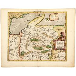
Tabula Sexta Asia (Arabian Peninsula)
This is a very desirable early Ptolemaic woodblock map of the Arabian Peninsula, here called Arabia Felix. The map is presented on a trapezoidal projection with para...
Date: Vienna, 1525 -1541

Tabula Superioris Indiae & Tartariae maioris. (Modern Map of China, Japan, etc.)
Important map extending from Tartary in the north, to "Prov. Bocat" (Cambodia) in the south. "Tebet" is shown prominently, as is "Zinpangri"...
Date: Vienne, 1541

Tabula nova utriusque Indiae.
This is the fourth and last edition of this map based on Waldseemüller's first "modern" map of Asia. It follows that cartography without change but adds an inte...
Date: Vienne, 1541
![Tabula XII - Asiae [Taprobana Ins - Ceylon/Sri Lanka]](/uploads/cache/40249-250x250.jpg)
Tabula XII - Asiae [Taprobana Ins - Ceylon/Sri Lanka]
Map of Taprobana (Sri Lanka) which depicts the typical misconceptions of Ptolemy showing the island greatly enlarged, surrounded by imaginary islands, and with a small pa...
Date: Vienne, 1541
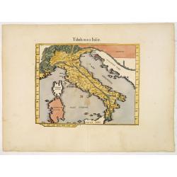
.Tabula nova Italiae. (Modern Italy)
Wood block printed modern map of Italy, prepared by Lorenz Fries and one of the earliest modern maps of Italy and environs. Based on the slightly larger map from 1513 pub...
Date: Vienna, 1525 -1541
![[Europe, Eastern, Sarmatia, Ukraine]](/uploads/cache/33854-250x250.jpg)
[Europe, Eastern, Sarmatia, Ukraine]
Wood block printed map and one of the earliest printed representations of European Sarmatia, generally the region between the Baltic and Black Sea and Sea of Azov. Includ...
Date: Vienna, Trechsel, G., 1525 -1541
![.[Pakistan, Afghanistan]](/uploads/cache/33849-250x250.jpg)
.[Pakistan, Afghanistan]
Wood block printed Ptolemaic map of the region of present-day Pakistan and part of Afghanistan. Convoluted mountain ranges and river systems dominate the trapezoidal map....
Date: Vienna, Trechsel, G., 1525 -1541
![.[Balkan region with Austria, Croatia, Slovenia, Switzerland, etc]](/uploads/cache/33858-250x250.jpg)
.[Balkan region with Austria, Croatia, Slovenia, Switzerland, etc]
Wood block printed map and one of earliest printed representation of Balkan with Austria, Croatia, Slovenia, Switzerland, etc prepared Martin Waldseemüller. Based on the ...
Date: Vienna, 1525 -1541
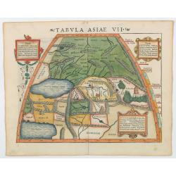
Tabula Asiae VII.
Attractive woodblock map, depicting the Caspian Sea, Black Sea and the Persian Gulf, extending to the Imaus Mountains. according to Ptolemy. In the center of the map is...
- $500 / ≈ €437
Date: Basle, 1542
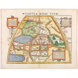
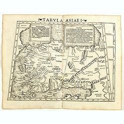
Tabula Asiae VII.
Attractive woodblock map, depicting the Caspian Sea, Black Sea and the Persian Gulf, extending to the Imaus Mountains. according to Ptolemy. In the center of the map is...
Date: Basle, 1542
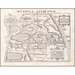
Tabula Asiae VII.
Attractive woodblock map, depicting the Caspian Sea, Black Sea and the Persian Gulf, extending to the Imaus Mountains, according to Ptolemy. In the center of the map is m...
Date: Basle, 1542
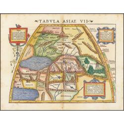
Tabula Asiae VII.
Attractive woodblock map, depicting the Caspian Sea, Black Sea and the Persian Gulf, extending to the Imaus Mountains. according to Ptolemy. In the center of the map is...
Date: Basle, 1542
Tabula Asiae I (Turkey)
The first edition of Munster's map of Turkey, based upon Claudius Ptolemy which appeared in his "Geographia Universalis", first published in 1540. The Geographi...
- $500 / ≈ €437
Date: Basel, Heinrich Petri, 1545
Tabula Asiae V. (Persia)
The first edition of Munster's map between the Persian Gulf and the Caspian Sea, extending from Armenia and Mesopotamia eastward, based upon Claudius Ptolemy which appear...
- $300 / ≈ €262
Date: Basel, Heinrich Petri, 1545
Tabula Asiae II (Black Sea and Caspian Sea).
The first edition of Münster's map of Ukraine and the region north of the Black Sea, based upon Claudius Ptolemy which appeared in his "Geographia Universalis",...
- $400 / ≈ €350
Date: Basel, Heinrich Petri, 1545
Tabula Asiae II (Black Sea and Caspian Sea)
The first edition of Munster's map of Ukraine and the region north of the Black Sea, based upon Claudius Ptolemy which appeared in his "Geographia Universalis",...
Date: Basel, Heinrich Petri, 1545
Tabula Europae II. (Spain and Portugal)
Gastaldi's map showing Spain and Portugal, based upon Ptolemy.It is one of the earliest obtainable maps of the region.From Giacomo Gastaldi's Atlas of 1548 which has been...
- $375 / ≈ €328
Date: Venice, 1548

Tabula Asiae IIII. (Cyprus, Holy Land, Syria, Jordan, Iraq)
Gastaldi's map showing Cyprus, the Holy Land, Syria, Jordan and Iraq, based upon Ptolemy's map It is one of the earliest obtainable maps of the region.From Giacomo Gastal...
- $350 / ≈ €306
Date: Venice, 1548
Tabula Asiae I.
Gastaldi's map of Asia Minor and the Bosporus Straits, based upon Ptolemy.It is one of the earliest obtainable maps of the region .From Giacomo Gastaldi's Atlas of 1548 w...
- $400 / ≈ €350
Date: Venice, 1548
Tabula Africae IIII.
Gastaldi's map of Northern Africa, based on Ptolemy. Showing all of the Mediterranean, the Ethiopian Interior, the Red Sea, Egypt, the source of the Nile, the Dead Sea, e...
- $400 / ≈ €350
Date: Venice, 1548
![[Lot of 25 leaves of France, Brabant, Netherlands, Luxemburg]](/uploads/cache/48264-250x250.jpg)
[Lot of 25 leaves of France, Brabant, Netherlands, Luxemburg]
1552 MÜNSTER, S. - Twenty-five text leaves with wood block illustrations relating to France, Brabant, the Netherlands and Luxembourg
Date: Basel, 1552
![[Lot of 10 leaves] Catalogus doctorum…in Cosmographia Sebastiani…/ Index Cosmographicus.](/uploads/cache/48294-250x250.jpg)
[Lot of 10 leaves] Catalogus doctorum…in Cosmographia Sebastiani…/ Index Cosmographicus.
Ten leaves with several wood blocks with an index taken from the "Cosmographia". From the 1552 Latin text edition of Münster's Cosmographia, which is a short an...
Date: Basel, 1552
![[Lot of 2 leaves] Vienna Austriae metropolis, urbs…](/uploads/cache/48268-250x250.jpg)
[Lot of 2 leaves] Vienna Austriae metropolis, urbs…
1552 MÜNSTER, S. - Two early panoramic views of Vienna on a text page.
Date: Basel, 1552
![[Lot of 2 leaves] Rubeaquum cum arce Isenburgo…/ Wyssenburg…](/uploads/cache/48269-250x250.jpg)
[Lot of 2 leaves] Rubeaquum cum arce Isenburgo…/ Wyssenburg…
Two wood block printed early bird's-eye views of Rouffach (lies along the Alsatian wine route) and Wissembourg (Alsace). From the 1552 Latin text edition of Münster's Cos...
Date: Basel, 1552
![[Lot of 7 leaves] Curiensis civitas, Rhetorum…/Valesia/Solothurensis/Clarissimae civitatis/Genevensis/Basiliensis/Ursina…Bernensis/Sedunensis/Designatio …Badensis.](/uploads/cache/48278-250x250.jpg)
[Lot of 7 leaves] Curiensis civitas, Rhetorum…/Valesia/Solothurensis/Clarissimae civitatis/Genevensis/Basiliensis/Ursina…Bernensis/Sedunensis/Designatio …Badensis.
1552 MÜNSTER, S. - Seven text leaves illustrated with wood block bird's-eye views of Chur, Solothurn, Geneva, Basel, Bern, Sitten, Baden
Date: Basel, 1552
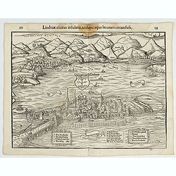
Lindoiae civitas insularis, undique aqua lacunari circunsusa.…
A wood block printed early bird's-eye view of Lindau on Lake Constance (Germany). A lettered key A-O in the plate. From the 1552 Latin text edition of Münster's Cosmograp...
Date: Basel, 1552
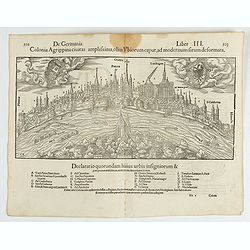
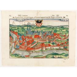
Colonia Agrippina civitas…
A wood block printed early panoramic view of Cologne (Germany). A lettered key A-Z beneath the view. The 1552 Latin text edition of Münster's Cosmographia is a short and ...
- $70 / ≈ €61
Date: Basel, 1552

[Lot of 9 leaves with maps and views of Persia and Arabia).
Nineteen text leaves with wood block illustrations relating to Persia and Arabia, from the 1552 Latin text edition of Münster's Cosmographia, which is a short and complet...
Date: Basel, 1552
![[Lot of 6 leaves] Civitas Augustana olim Vindelica…/Sueviae et Bavariae Descriptio/ Franckfordiae ad Oderam imago…/Franckofordianae civitatis…/Erdfordia magnifica …Thuringoru urbs…Fuldensis civitatis… / Lubecum una ex praeclarioribus. . .](/uploads/cache/48258-250x250.jpg)
[Lot of 6 leaves] Civitas Augustana olim Vindelica…/Sueviae et Bavariae Descriptio/ Franckfordiae ad Oderam imago…/Franckofordianae civitatis…/Erdfordia magnifica …Thuringoru urbs…Fuldensis civitatis… / Lubecum una ex praeclarioribus. . .
1522 MÜNSTER, S. - Six text leaves with wood block printed views and maps of Augsburg, Frankfurt /Oder, Frankfurt am Main, Erfurt and Fulda, Lübeck and a map of Swabia a...
Date: Basel, 1552
![[Lot of 205 leaves of Germany, Austria, Switzerland, Alsace and Brabant].](/uploads/cache/48263-250x250.jpg)
[Lot of 205 leaves of Germany, Austria, Switzerland, Alsace and Brabant].
1552 MÜNSTER, S. - 205 text leaves illustrated with wood block views and maps relating to Germany, Austria, Switzerland, Alsace and Brabant
Date: Basel, 1552
![[Lot of 5 leaves] Noerdlinga civitas imperialis…/ Nemetum civitatis…Spiram appellant / Situs & figura… Trevirensis / Situs civitatis Confluentinae… / Civitas Lunaeburgensis…](/uploads/cache/48259-250x250.jpg)
[Lot of 5 leaves] Noerdlinga civitas imperialis…/ Nemetum civitatis…Spiram appellant / Situs & figura… Trevirensis / Situs civitatis Confluentinae… / Civitas Lunaeburgensis…
1552 MÜNSTER, S. - Five text leaves with woodblock-printed early bird's-eye views of Nördlingen, Speyer, Trier, Koblenz, and Lüneburg
Date: Basel, 1552
Dell Germania Egrana.
Early woodcut view of the city of Egra (Cheb) in the Czech Republic. From the 1552 Latin text edition of Münster's Cosmographia, which is a short and complete summary of ...
Date: Basel, 1552
Tabula Asiae XI.
Attractive early woodblock map of the Indian Ocean, extending from Southeast Asia to the Ganges River and north to the Himalayas.In upper left inset panel of tiger, cocke...
- $600 / ≈ €525
Date: Basle, H. Petri, c. 1552
Tabula Europae IIII.
The scarce FIRST edition of this classical map depicting Northern Europe, Denmark and the Baltic. Includes engravings of a number of interesting animals in the right-hand...
Date: Venice, 1561
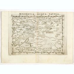
Moschovia nuova tavola.
Scarce FIRST edition of this map centered on Moscow. In the lower left Crimea and the Sea of Azov. The map is filled with small tents to represent Tartar camps.Girolamo R...
Date: Venice, 1561
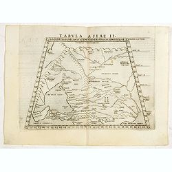
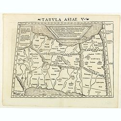
Tabula Asiae II.
Scarce FIRST edition of this map of the ancient region of Asiatic Sarmatia - now Southern Russia and part of Ukraine, around the Azov seaGirolamo Ruscelli's edition of Pt...
Date: Venice, 1561
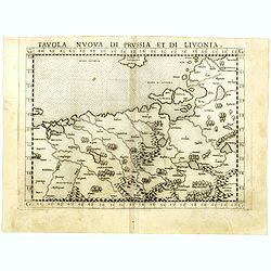
Tavola nuova di Prussia et di Livonia.
Uncommon first edition of this early map of the region from Pomerania to Livonia, includes a portion of Estonia, and coastal detail on the Baltic Sea with a small section...
- $400 / ≈ €350
Date: Venice, Vincenzo Valgrisi, 1561
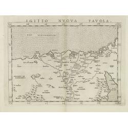
Egitto nuova tavola.
Fine early map of Egypt and the Nile delta. Extends east to the Upper Red Sea and West to "Deserto De Marmarica". Nice detail in the lower Nile regions. Page ta...
Date: Venice, 1561
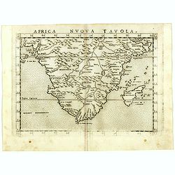
Africa nuova tavola.
Uncommon first edition of this early map of South Africa. Madagascar is called Isola de S. Lorenzo and is oddly shaped.The origin of the Nile conforms to the Ptolemaic co...
- $550 / ≈ €481
Date: Venice, Vincenzo Valgrisi, 1561
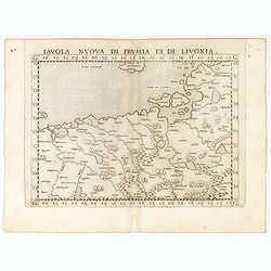
Tavola nuova di Prussia et di Livonia.
Uncommon first edition of this early map of the region from Pomerania to Livonia, includes a portion of Estonia, and coastal detail on the Baltic Sea with a small section...
Date: Venice, Vincenzo Valgrisi, 1561

Tierra Nueva.
Uncommon first edition of this early map of the east coast is an enlarged version of Giacomo Gastaldi map published in 1548. Nomenclature and cartography are unchanged, w...
Date: Venice, 1561
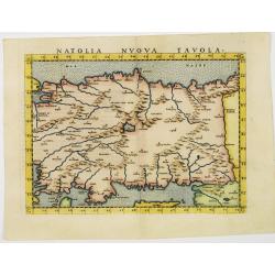
Natolia nuova tavola.
Uncommon first edition of this early map of Turkey.Girolamo Ruscelli's edition of Ptolemy's Geographia included newly engraved copperplates by Giulio and Livio Sanuto. Th...
- $375 / ≈ €328
Date: Venice, 1561
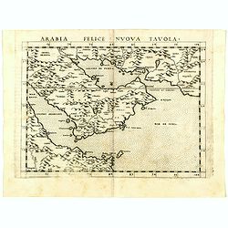
Arabia Felice Nuova Tavola.
Uncommon first edition of this modern map of Saudi Arabia, the Persian Gulf and Red Sea, for the first time it "clearly shows the island of Bahrain and Qatar".T...
Date: Venice, Vincenzo Valgrisi, 1561
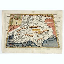
Sarmatia Asie.
The map is showing the area of Armenia and Kazakhstan. From his Cosmographia, that great compendium of Renaissance knowledge. Sebastian Münster was born in Nierder-Ingelh...
- $90 / ≈ €79
Date: Basle, 1550-1580
![[Map of the Holy Land, including Cyprus]](/uploads/cache/33436-250x250.jpg)
[Map of the Holy Land, including Cyprus]
Attractive full page longitudinal map of Palestine, Syria and Cyprus, cut by Hans Rudolf Manuel Deutsch. The shore line running from Southern Anatolia to the Nile Delta. ...
Date: Basle, 1550-1580
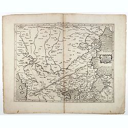
The Best Ptolemaic Map of Germany: Europ. IIII. Tab.
An elegantly engraved map of Germany as it was known in the Roman Imperial Period from Mercator’s definitive edition of Ptolemy’s geography. It was based on geographical ...
Date: Lyons, 1584
The Work of Two of History's Greatest Geographers. Morocco/ Algeria/ Tunisia/ Spain. Afr: I Tab:
A very attractive example of an early edition, the second, from Mercator’s definitive edition of Ptolemy’s geography. The map shows the area as it was known in the Roman ...
Date: Cologne, 1584
Tabula Asiae II.
A striking example of Magini's map of the Black Sea region from the 1597 edition of Magini's 'Geographia', based upon the work of Claudius Ptolemy. Latin text and tables ...
- $300 / ≈ €262
Date: Venice, 1597

Christophorus Columus Ligur Indiarum Prim invet A°1492
Very decorative portrait of Christopher Columbus (c. 31 October 1451 – 20 May 1506), engraved by Theodor de Bry (1528-1593) and published in Jean Jacques Boissard, "...
Date: Frankfurt a.M. 1597 - 1599
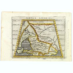
Tab. IX Europae, Continens Daciam, Misiam, Thraciam, ac Macedoniae partem.
Map of Dacia, Thrace and Macedonia -- or Byzantium from the Black Sea west to Greece. Including the site of Constantinople / Istanbul, the Dardanelles, Bosphorus, etc. By...
- $400 / ≈ €350
Date: Amsterdam, c.1600
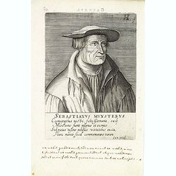
Sebastienus Munsterus.
Rare copper engraved portrait of Sebastian Münster (1488 – 1552) by Henricus Hondius (1573-1666) of The Hague. Published in Jacob Verheiden: "Praestantium aliquot th...
- $350 / ≈ €306
Date: The Hague, 1602
![[Title page] Geographiae libri octo Graeco-Latini . . .](/uploads/cache/47936-250x250.jpg)
[Title page] Geographiae libri octo Graeco-Latini . . .
Fine decorative titlepage from the 1605 edition of Ptolemy. The plate is adorned with allegorical figures, fruits and architectural motifs. This 1605 edition was based on...
Date: Amsterdam, 1605
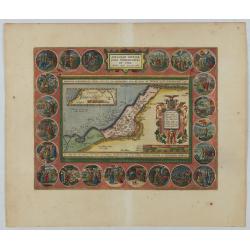
Abrahami Patriarchae Peregrinatio et Vita.
The Holy Land map itself occupies the center and is surrounded by vignettes of the life of the Patriarch Abraham. Extremely decorative map made by Ortelius, based on Ptol...
Date: Antwerp, 1624
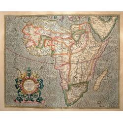
Africa ex magna orbis terre descriptione Gerardi Mercator. . .
Map of Africa. Much of the interior of Africa defers to the traditions of Ptolemy. The Nile river is shown with the two lakes and the Mountains of the Moon across souther...
Date: Amsterdam, 1630

Nova Totius Terrarum Orbis Geographica..
The first of four states of the map. French text on verso. One of the most beautiful world maps ever engraved and one of the most influential in promulgating the Californ...
Date: Amsterdam, 1630-1633
![[Title page from Theatrum orbis Terrarum, with past-on]](/uploads/cache/43860-250x250.jpg)
[Title page from Theatrum orbis Terrarum, with past-on]
The frontispiece of the third part of the 'Theatrum', by Johan Blaeu. Heightened with goldDecorated with terrestrial and celestial globes and to the left Ptolemy (with sp...
Date: Amsterdam, ca. 1650
![[Title page] Theatrum orbis Terrarum sive Atlas Novus pars Tertia.](/uploads/cache/43695-250x250.jpg)
[Title page] Theatrum orbis Terrarum sive Atlas Novus pars Tertia.
Glorious mid-seventeenth century engraved frontispiece by Joan and Cornelis Blaeu from the third part of his 'Theatrum Orbis Terrarum'. Finely decorated with a pair of te...
- $350 / ≈ €306
Date: Amsterdam, 1650
