Search Listings matching "ptolemy"

Sumatrae et insularum Locorumque nonnullorum circumiacentium. . .
Fine depicting the Island of Sumatra and the southern coasts of Malaysia from Quedo to Johore.North is orientated to the left of the page.Singapore is probably identifie...
Date: Amsterdam, 1660
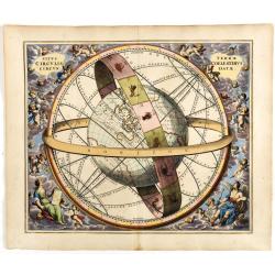
Situs Terrae Circulis Coelestibus circundatae..
A celestial chart depicting a large globe centered on Australia and the Pacific, with California depicted as an island, and South East Asia encircled by the zodiacal band...
Date: Amsterdam, Janssonius, 1660
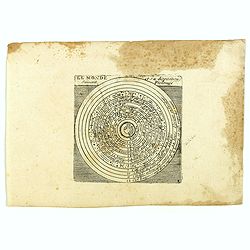
Le monde et sa disposition suivant Ptolomée.
The Christian Aristotelian cosmos. Ptolemy accepted the following order for celestial objects in the solar system: Earth (center), Moon, Mercury, Venus, Sun, Mars, Jupite...
- $150 / ≈ €126
Date: Paris, 1667
![[Title page to] Atlas mayor, o geographia Blaviana : Que contiene las cartas, y descripciones de Partes Orientales de Europa.](/uploads/cache/29952-250x250.jpg)
[Title page to] Atlas mayor, o geographia Blaviana : Que contiene las cartas, y descripciones de Partes Orientales de Europa.
Title page from a Spanish text edition of the Atlas Major. Ionic portico with celestial and terrestrial globes. To the left is Ptolemy with a sphere and a pair of compass...
Date: Amsterdam, c.1672

A unique composite atlas with updated Porro maps.
Unique composite atlas containing in total 84 maps - 82 maps engraved by Girolamo Porro and heavenly reworked around 1686 and 2 newly engraved maps; Piccola Tartaria (Cr...
Date: Venice, 1686
![[A magnificent 18 inch. (46 cm.) diameter celestial globe] URANOGRAPHIA / SYDERUM ET STELLARUM / in Singulis Syderibus conspicuarum / exhibens Delineationem accuratissimam,](/uploads/cache/48959-250x250.jpg)
[A magnificent 18 inch. (46 cm.) diameter celestial globe] URANOGRAPHIA / SYDERUM ET STELLARUM / in Singulis Syderibus conspicuarum / exhibens Delineationem accuratissimam,
RARE FIRST STATE OF THIS CELESTIAL TABLE GLOBE, 46 cm in diameter, produced by Gerard and Leonard Valk at the beginning of the 18th century. The globe comprises of t...
Date: Amsterdam, 1711
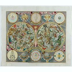
Planisphaerum coeleste.
A very decorative double hemisphere celestial chart. The 10 smaller circular diagram showing the rotation of the Planets, according to Tycho Brahe, Ptolemy and Copernicus...
Date: Nurenberg, 1750
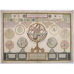
Introduction a la géographie carte des diverses positions de la sphere..
A charming and large print showing a terrestrial, celestial and an armillary globe with smaller circular diagrams illustrating the theories of Ptolemy, Copernicus, Brahe ...
- $1000 / ≈ €843
Date: Paris 1750
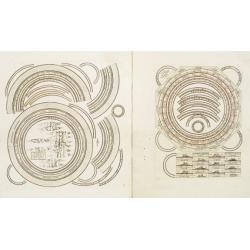
Two sheets for constructing an armillary sphere.
Two sheets for constructing an armillary sphere. Cassini was a geographer and cartographer, but also perspective and architecture carver - one of Giovanni Battista Pirane...
Date: Rome, 1795
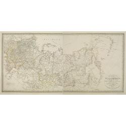
Charte des ganzen Russischen Reichs in Europa und Asien : Nach den neuesten und sichersten astronomischen Ortsbestimmungen entworfen und berichtiget auf der Sternwarte Seeberg bey Gotha gezeichnet von I. C. M. Reinecke. . .
Uncommon two-sheet map of Russia, prepared by Johann Matthias Christoph Reinecke (1770-1818). The map's information is off by 20 degrees longitude as the prime meridian ...
Date: Weimar, 1817

Carte d'Afrique Dressée pour l'instruction par Guillaume DeLisle. . .
The map is a rare re-issue of the Delisle map of 1722. In his first map of the continent in 1700, Delisle re-measured the Mediterranean, being the first to establish its ...
Date: Paris, J.Dezauche, 1819
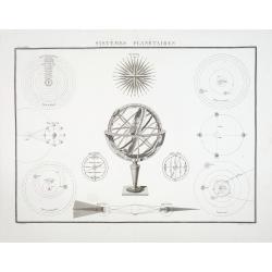
Systémes Planétaires
A charming print showing an armillary globe with smaller circular diagrams illustrating the theories of Ptolemy, Copernicus, Brahe, etc. Published by Alexandre Emile Lapi...
- $150 / ≈ €126
Date: Paris, 1830