Search Listings matching "plancius"

Peregrinatie Jesu Christu Een ordentliche beschrijvinge des Heijligen landts....
Very rare separately map of the Holy Land engraved by Joannes van Doetecum Jr. Oriented to the east. The shoreline runs from "Antaradus" in Syria to "Rhino...
Date: Amsterdam, ca. 1595
![Insulae Philippinae [Philippines].](/uploads/cache/49446-250x250.jpg)
Insulae Philippinae [Philippines].
A miniature map of Philippines, centered on Mindanao and Luzon. Title cartouche on the upper left corner. First published in 1598 in his Caert-Thresoor, the plates were e...
Date: Amsterdam, 1598/ca. 1600
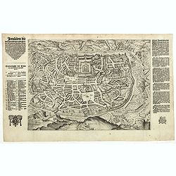
Jerusalem die vernaamste van alle steden... / Jerusalem die Heijlighe Stadt van God. . .
Very rare separately published plan of Jerusalem, engraved by Joannes van Doetecum Jr., Variant to Poortman, Kaarten in Bijbels, map 64. In the lower part, the copper pla...
Date: Amsterdam, 1598-1630
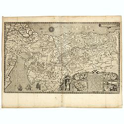
Pere Grinatie. De Reijse der Kinderen Israels so zij wt Egip . . .
Scarce separately engraved map of the Holy Land by Joannes van Doetecum Jr.In the lower right corner, inset with a title cartouche surrounded by Aaron, the encampment of ...
Date: Amsterdam, 1598, The Hague, 1632

Composite atlas of the Low Countries.
A unique, made-to-order atlas comprising 18 double-page engraved maps by or after Hessel Gerritsz, Theodoor Galle, Jacob van Deventer, Gerard Mercator, Peter Verbiest, Je...
Date: [Antwerp, c. 1633
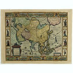
Asiae Nova Descriptio.
Final State of Pieter Van Den Keere's Rare Map of Asia--The first map of Asia to include decorative panels.The map has an interesting south positioning of the Caspian Sea...
Date: Amsterdam, 1636
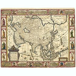
Asiae Nova Descriptio.
Final State of Pieter Van Den Keere's Rare Map of Asia -- The first map of Asia to include decorative panels. Published by N.J.Visscher and engraved by Abraham Goos, embe...
Date: Amsterdam, 1636
Histoire de la Navigation.
A fine example of Linschoten's classic illustrated travelogue to the East and West Indies, termed by Lach “the most important of the firsthand accounts published indepe...
Date: Amsterdam, Evert Cloppenburgh, 1638
![[A magnificent 18 inch. (46 cm.) diameter celestial globe] URANOGRAPHIA / SYDERUM ET STELLARUM / in Singulis Syderibus conspicuarum / exhibens Delineationem accuratissimam,](/uploads/cache/48959-250x250.jpg)
[A magnificent 18 inch. (46 cm.) diameter celestial globe] URANOGRAPHIA / SYDERUM ET STELLARUM / in Singulis Syderibus conspicuarum / exhibens Delineationem accuratissimam,
RARE FIRST STATE OF THIS CELESTIAL TABLE GLOBE, 46 cm in diameter, produced by Gerard and Leonard Valk at the beginning of the 18th century. The globe comprises of t...
Date: Amsterdam, 1711
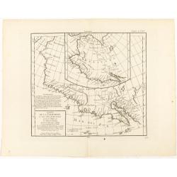
Carte de la Californie et des Pays Nord-Ouest..
From Diderot's Encyclopedia. Fascinating study of the comparative cartography of the West Coast of North America, from the Straits of Anian to Cabo San Lucas and the sout...
Date: Paris, 1772
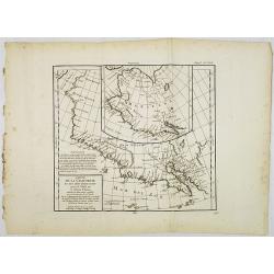
Carte de la Californie et des Pays Nord-Ouest. . . 4de Carte.
Diderot's famous 2 on 1 map shows the two early mappings of the west coast of North America, the first after Visscher, the second after Plancius' World map. Both show the...
- $200 / ≈ €170
Date: Paris, 1779

