Search Listings matching "mercator"
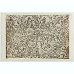
Typus Universalis Terrae, Iuxta Modernorum Distinctionem Et Extensionem Per Regna Et Provincias.
FIRST BLOCK - Rare world map from Gregor Reisch's Magarita Philisophica, published in Basle in 1583.In 1544, Peter Apian incorporated a world map into his Cosmographia, b...
Date: Antwerp c.1544-1553
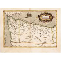
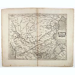
The Work of Two of History's Greatest Geographers. Morocco/ Algeria/ Tunisia/ Spain. Afr: I Tab:
A very attractive example of an early edition, the second, from Mercator’s definitive edition of Ptolemy’s geography. The map shows the area as it was known in the Roman ...
Date: Cologne, 1584
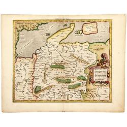
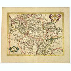
The Best Ptolemaic Map of Germany: Europ. IIII. Tab.
An elegantly engraved map of Germany as it was known in the Roman Imperial Period from Mercator’s definitive edition of Ptolemy’s geography. It was based on geographical ...
Date: Lyons, 1584
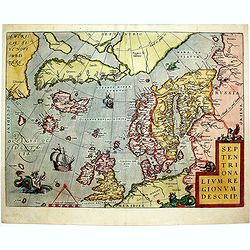
Septentrionalium Regionum Descrip.
1584 ORTELIUS, A. - Scandinavia, Iceland, Greenland and part of the North American continent, includes also the legendary islands of i.a. Drogeo, Frisland and Icaria.
Date: Antwerp, 1584
ARTESIA Comit.
Mercator's early map of the northern French region of Artois. Divisions in outline colors, strap-work title cartouche and mileage scale in the upper right, and lower left...
Date: Duisbourg, 1585
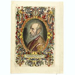
(Portrait of Abraham Ortelius)
The famous head and shoulder portrait of Ortelius aged 50, engraved by Philippe Galle, included in his atlas. famous cartographer born in Antwerp and, after studying Gree...
- $700 / ≈ €612
Date: Antwerp, 1592

ABRAHAMUS ORTELIUS ANTVERPIANUS Orteli dum proponis spectantibus Orbem, Quam tua delectant structa Theatra homines! . . .
Portrait of Abraham Ortelius (Abraham Ortel), famous cartographer born in Antwerp and after studying Greek, Latin and mathematics set up business there with his sister, a...
Date: Antwerp, c.1595

Angliae, scotiae, et Hiberniae, sive Britannicar:insularum.
Fine general map of the British Isles and Ireland on horizontal projection with north to right of page. Derived from Mercator's 1564 map of the British Isles.Dare to go i...
Date: Anwerp, 1598

Angliae Regni florentissimi nova descriptio..
Fine general map of England derived from Mercator's 1564 map of the British Isles in 8 sheets.Dare to go in Black. All early maps were printed in black and white; many we...
Date: Antwerp, 1598
Tab. IX Europae, Continens Daciam, Misiam, Thraciam, ac Macedoniae partem.
Map of Dacia, Thrace and Macedonia -- or Byzantium from the Black Sea west to Greece. Including the site of Constantinople / Istanbul, the Dardanelles, Bosphorus, etc. By...
- $400 / ≈ €350
Date: Amsterdam, c.1600
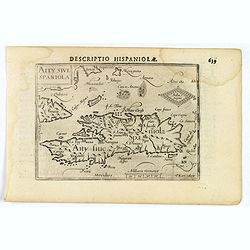
Decriptio Hispaniolae.
A miniature map of Hispaniola, (modern day Haiti and Dominican Republic), as well as the extreme eastern parts of Cuba. With a simple strap-work title and a scale in Germ...
- $150 / ≈ €131
Date: Amsterdam, 1606

Ormus (Straits of Hormus)
A lovely miniature map of the Kingdom of Ormus, published by Petrus Bertius, and published in Amsterdam at the beginning of the seventeenth century. With an attractive st...
Date: Amsterdam, 1606

Arabia
A lovely miniature map the Arabian Peninsular, published by Petrus Bertius, and published in Amsterdam at the beginning of the seventeenth century. With an attractive st...
Date: Amsterdam, 1606
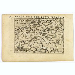
Flandria.
A lovely set of miniature map of Flanders. With an attractive strap-work title, and with detailed topography and information. Bertius (1565-1629) was a Flemish cartograph...
Date: Amsterdam, 1606
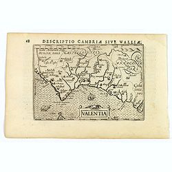
Valentia.
A fine miniature map of the Spanish province of Valencia, published by Petrus Bertius in Amsterdam early in the seventeenth century. The map features a nice strap-work ti...
Date: Amsterdam, 1606
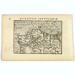
Portugallia.
A nice miniature map of Portugal, published by Petrus Bertius, in Amsterdam, at the beginning of the seventeenth century. North is orientated to the right. Strap-work tit...
Date: Amsterdam, 1606
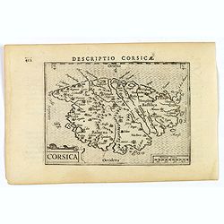
Corsica.
A fine miniature map of the French island of Corsica, published by Petrus Bertius in Amsterdam early in the seventeenth century. The map features a strap-work title carto...
Date: Amsterdam, 1606
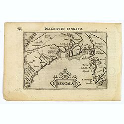
Bengala.
A lovely miniature map of a section of the Bay of Begal, published by Petrus Bertius, in Amsterdam at the beginning of the seventeenth century. There is a decorative stra...
Date: Amsterdam, 1606
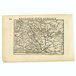
Hungaria.
A lovely miniature map of Hungary, published by Petrus Bertius, in Amsterdam at the beginning of the seventeenth century. There is a decorative strap-work title, and the ...
Date: Amsterdam, 1606
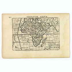
Africa.
A lovely miniature map of the continent of Africa, published by Petrus Bertius, in Amsterdam at the beginning of the seventeenth century. There is a small strap-work titl...
Date: Amsterdam, 1606
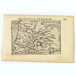
Gasconia.
A lovely miniature map of Gascony, in the S.W. region of France, published by Petrus Bertius, in Amsterdam at the beginning of the seventeenth century. There is a small s...
Date: Amsterdam, 1606
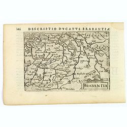
Brabantia.
A lovely miniature map of the Duchy of Brabant, published by Petrus Bertius, in Amsterdam at the beginning of the seventeenth century. There is a nice, small strap-work t...
Date: Amsterdam, 1606
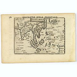
India Orientalis.
This lovely miniature map shows the East Indies, stretching from Persia to China and Japan, down to Java, and part of Papua new Guinea. Published by Petrus Bertius, in Am...
Date: Amsterdam, 1606
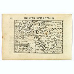
Turcicum Imperium.
A really attractive miniature map of The Turkish Empire, as it was at the beginning of the seventeenth century. Published by Petrus Bertius in Amsterdam. The map stretche...
Date: Amsterdam, 1606
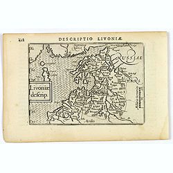
Livoniae descrip.
An attractive miniature map of the Baltic region of Livonia, as it was at the beginning of the seventeenth century, and published by Petrus Bertius in Amsterdam. The map ...
Date: Amsterdam, 1606
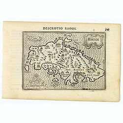
Rhodi.
A beautiful miniature map of the Greek island of Rhodes, published by Petrus Bertius in Amsterdam at the beginning of the seventeenth century.Engraved by Petrus Kaerius. ...
Date: Amsterdam, 1606
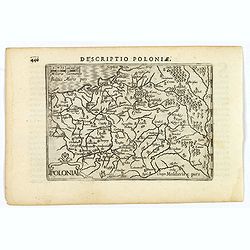
Polonia.
A miniature map of the Polish-Lithuanian Commonwealth, published by Petrus Bertius, in Amsterdam at the beginning of the seventeenth century. It features a small strap-wo...
Date: Amsterdam, 1606
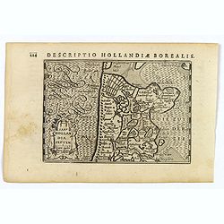
Hollandia Septentrionalis.
An attractive miniature map of the north Holland, northwards from Amsterdam to the Zijpe polder, published by Petrus Bertius, in Amsterdam at the beginning of the sevente...
Date: Amsterdam, 1606
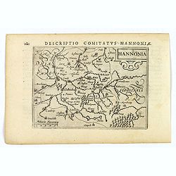
Hannonia.
An attractive miniature map of the Belgian, region of Hainaut, published by Petrus Bertius, in Amsterdam at the beginning of the seventeenth century. It features a small ...
Date: Amsterdam, 1606
![Descriptio Gadium [France].](/uploads/cache/43237-250x250.jpg)
Descriptio Gadium [France].
An attractive miniature map of France, published by Petrus Bertius, in Amsterdam at the beginning of the seventeenth century. Title in bold capital letters above map, sti...
Date: Amsterdam, 1606
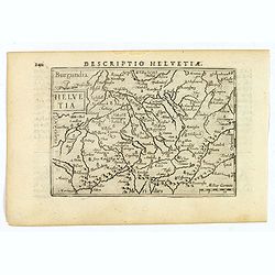
Helvetia.
A lovely miniature map of Switzerland, published by Petrus Bertius, in Amsterdam at the beginning of the seventeenth century.Full of facinating topographical detail, and ...
Date: Amsterdam, 1606
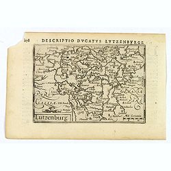
Lutzenburg.
A lovely miniature map of the small, landlocked European country of Luxembourg, published by Petrus Bertius, in Amsterdam at the beginning of the seventeenth century. The...
Date: Amsterdam, 1606
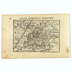
Europa.
A lovely miniature map of the continent of Europe, published by Petrus Bertius, in Amsterdam at the beginning of the seventeenth century.Engraved by J. Hondius, it has a ...
Date: Amsterdam, 1606
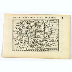
Tirolis Comita.
A lovely miniature map of the Tyrol region in the Alps, published by Petrus Bertius, in Amsterdam at the beginning of the seventeenth century. The map has a plain strap-w...
- $80 / ≈ €70
Date: Amsterdam, 1606
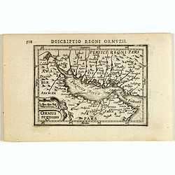
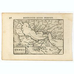
Descriptio Regni Ormuzii / Ormus.
A lovely miniature map of the Kingdom of Ormus, published by Petrus Bertius, and published in Amsterdam at the beginning of the seventeenth century. With an attractive st...
Date: Amsterdam, 1606
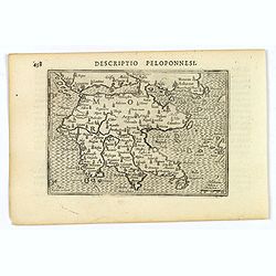
Descriptio Peloponnesi.
A fine miniature map of the southern Greek provence of Morea, the middle ages term for the Peloponnese peninsular, published by Petrus Bertius in Amsterdam early in the s...
- $100 / ≈ €87
Date: Amsterdam, 1606
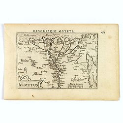
Aegyptus.
A fine miniature map of Egypt, published by Petrus Bertius in Amsterdam early in the seventeenth century. The lovely map and has a strap-work title, in the lower left cor...
- $100 / ≈ €87
Date: Amsterdam, 1606
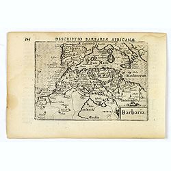
Barbaria.
A nice miniature map of the north African region known as 'Barbary', published by Petrus Bertius in Amsterdam early in the seventeenth century. This lovely map also depic...
- $100 / ≈ €87
Date: Amsterdam, 1606
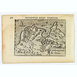
Carthaginensis Sinus.
A beautifully miniature map by Petrus Bertius of the ancient city of Carthage and the more modern town of Tunis, first published in 1598. There are numerous features tha...
- $100 / ≈ €87
Date: Amsterdam, 1606
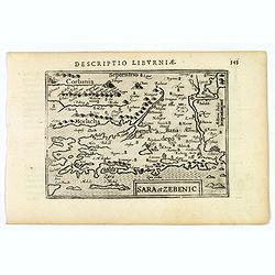
Sara et Zebenic.
A miniature map of Sara & Zebenic - in Croatia / Dalmatia in Eastern Europe, published by Petrus Bertius in Amsterdam, at the beginning of the seventeenth century. An...
- $100 / ≈ €87
Date: Amsterdam, 1606
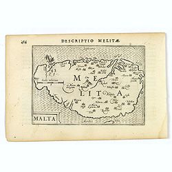
Malta.
A miniature map of the lovely Mediterranean island of Malta, published by Petrus Bertius in Amsterdam, at the beginning of the seventeenth century. An attractive small ma...
- $200 / ≈ €175
Date: Amsterdam, 1606
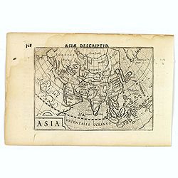
Asia.
A miniature map of the continent of Asia, published by Petrus Bertius in Amsterdam, at the beginning of the seventeenth century. An attractive small map featuring hatchin...
- $250 / ≈ €219
Date: Amsterdam, 1606
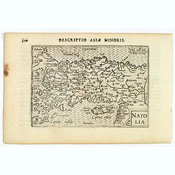
Natolia.
A miniature map of Turkish Natolia, published by Petrus Bertius in Amsterdam, at the beginning of the seventeenth century. This attractive small map features hatching in ...
- $150 / ≈ €131
Date: Amsterdam, 1606
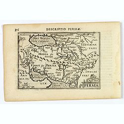
Persia.
A decorative miniature map of Persia, stretching from the Tigris River in the west to the Indus River in the east. As far north as the Caspian Sea. Published by Petrus B...
- $175 / ≈ €153
Date: Amsterdam, 1606
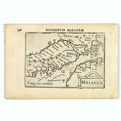
Malacca.
A nice miniature map of Malacca, A Malaysian state on the southern Malay peninsular, next to the Strait of Malacca. North is orientated to the left Published by Petrus B...
- $300 / ≈ €262
Date: Amsterdam, 1606
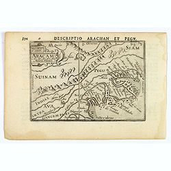
Aracam.
A rare miniature map of Thailand and Burma. Title cartouche on the upper left corner. First published in 1598 in his 'Caert-Thresoor', the plates were executed by the mos...
Date: Amsterdam, 1606
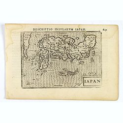
Iapon.
An attractive miniature map of Japan, published by Petrus Bertius, in Amsterdam at the beginning of the seventeenth century.The quirky map is shows the country in a disto...
- $250 / ≈ €219
Date: Amsterdam, 1606
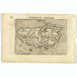
Descriptio Tercerae.
An attractive miniature map of The Azorian island of Terceira, in the Atlantic Ocean. Published by Petrus Bertius, in Amsterdam at the turn of the seventeenth century. Di...
- $100 / ≈ €87
Date: Amsterdam, 1606
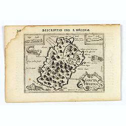
Sancta Helena.
An attractive small map of the south Atlantic island of St. Helena. Two years after the publication of the Itinerario, the first map of St. Helena appeared in 1598 in a m...
- $100 / ≈ €87
Date: Amsterdam, 1606
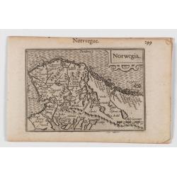
Norwegia.
An attractive and important miniature map Norway. The map is orientated to the west. The earliest map showing Norway.Prepared by Petrus Bertius, published in Amsterdam at...
Date: Amsterdam, 1606
Descriptio Regni Ormuzii / Ormus.
A lovely miniature map of the Kingdom of Ormus, published by Petrus Bertius, and published in Amsterdam at the beginning of the seventeenth century. With an attractive st...
- $450 / ≈ €393
Date: Amsterdam, Cornelis Claes, 1606
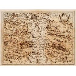
Stiria.
Detailed map of Stiria, the most eastern part of Austria, centered on Graz.Mercator was born in Rupelmonde in Flanders and studied in Louvain under Gemma Frisius, Dutch w...
Date: Amsterdam, 1606
Holsatia ducatus.
Map of Holsatia. Including the town of Hamburg.Mercator was born in Rupelmonde in Flanders and studied in Louvain under Gemma Frisius, Dutch writer, astronomer and mathem...
- $150 / ≈ €131
Date: Amsterdam, 1606

Inferior Germania.
A rare miniature map of present-day The Netherlands and Belgium. Strap-work title cartouche in the lower right corner with scale. Expertly engraved by Petrus Kaerius, the...
Date: Amsterdam, 1606
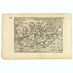
Caletensium et Bononiesium def.
An decorative miniature map of the N.W. France, including Calais and Boulogne. A map full of detail and attractive embelishments. North is orientated to the left. From th...
- $100 / ≈ €87
Date: Amsterdam, 1606
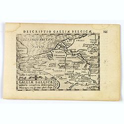
Descriptio Galliae Belgicae.
A decorative miniature map of a section of ancient France, and that of Belgium. Features a nice strap-work title, shows rivers and settlements. From the Bertius atlas Tab...
- $100 / ≈ €87
Date: Amsterdam, 1606
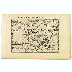
Picardia.
A decorative miniature map of Picardy, a historical northern French region. A map that appears to be sparsely populated is still full of detail with great attention to de...
Date: Amsterdam, 1606
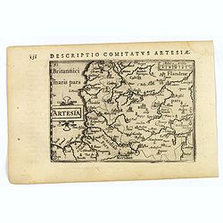
Artesia.
A decorative miniature map of Artois, a historical northern French province that borders Belgium. A map full of detail and is expertly engraved. With the cities of Boulo...
Date: Amsterdam, 1606
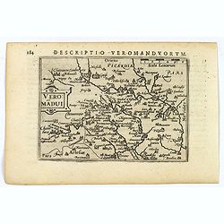
Descriptio Veromanduorum.
A decorative miniature map of Aisne (Vermandois), a French department in the Hauts-de-France region of northern France. It is named after the river Aisne. The map is cent...
Date: Amsterdam, 1606
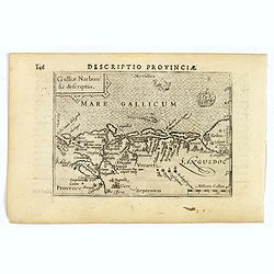
Descriptio Provinciae.
A decorative miniature map of Provence - a geographical region and historical province of south-eastern France, which extends from the left bank of the lower Rhône River ...
Date: Amsterdam, 1606
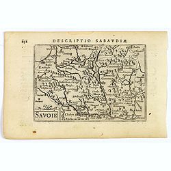
Savoie.
A decorative miniature map of Savoy - a cultural region in Central Europe that comprises roughly the territory of the Western Alps between Lake Geneva in the north and Da...
Date: Amsterdam, 1606
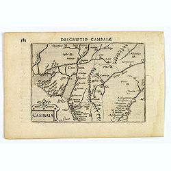
Descriptio Cambaiae.
A very decorative little map of northern India with Gujarat and the Indus river, bordering Pakistan. Naming major towns represented by symbols, major rivers, mountains, a...
- $100 / ≈ €87
Date: Amsterdam, 1606
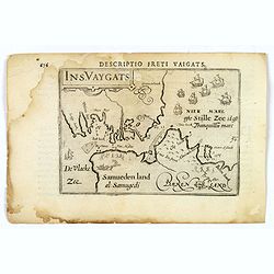
Descriptio Freti Vaigats.
Finely engraved map of the Vaigach Straits, from Bertius's rare miniature atlas. The map focuses on the straits between Novaya Zemlya and the Russian mainland, which had ...
- $150 / ≈ €131
Date: Amsterdam, 1606
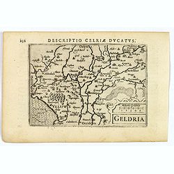
Geldria.
An original early 17th century copper engraved miniature antique map of the Dutch province of Gelderland by Petrus Bertius, that was published in Amsterdam at the beginni...
- $100 / ≈ €87
Date: Amsterdam, 1606

Ultrajectum.
An original early 17th century copper engraved miniature antique map of the Dutch province of Utrecht by Petrus Bertius, that was published in Amsterdam at the beginning ...
Date: Amsterdam, 1606
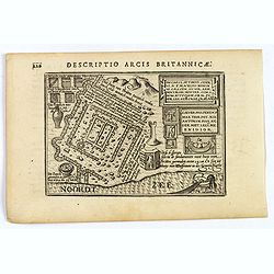
Descriptio Arcis Britannicae.
An original early 17th century copper engraved miniature antique map of the Roman remains in the sand dunes near Katwijk aan Zee in south Holland by Petrus Bertius. In Ro...
- $100 / ≈ €87
Date: Amsterdam, 1606
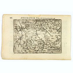
Descriptio Transisalaniae.
An original early 17th century copper engraved miniature antique map of the eastern Dutch region of Overijssel by Petrus Bertius. The title is displayed in a simple strap...
- $100 / ≈ €87
Date: Amsterdam, 1606
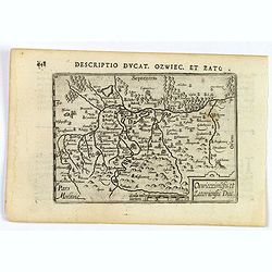
Descriptio Ducat. Ozwiec. et Zato.
An original early 17th century copper engraved miniature antique map of the Oswiecim (Auschwitz) and Zator area of southern Poland by Petrus Bertius. The title is display...
- $100 / ≈ €87
Date: Amsterdam, 1606
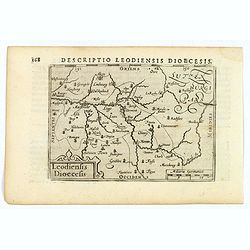
Descriptio Leodiensis Dioecesis.
A decorative map of the ancient Diocese of liege in Belgium, highlighting cities such as Huy, Liege, Tongeren (old capital), Namur and Maastricht. North is orientated to ...
- $100 / ≈ €87
Date: Amsterdam, 1606
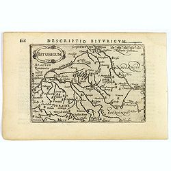
Descriptio Biturigum.
A charming small map of central France. Showing the areas around the rivers Loire, Auron, Allier and Yevre. Nevers and Bourges depicted. From the Bertius atlas Tabularum ...
- $100 / ≈ €87
Date: Amsterdam, 1606
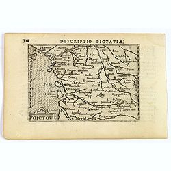
Descriptio Pictaviae.
A charming small map of Poitou in west central France. Showing Cognac, Limoges, Perigord, Poitiers and Angouleme. From the Bertius atlas Tabularum geographicarum contract...
Date: Amsterdam, 1606
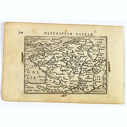
Descriptio Galliae.
A charming small map of ancient Gaul, France under Roman occupation. Featuring most major cities, rivers, mountains and regions are named. From the Bertius atlas Tabularu...
Date: Amsterdam, 1606
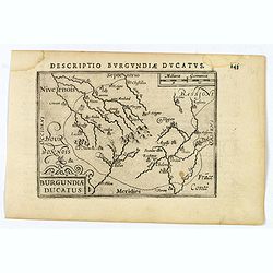
Descriptio Burgundiae Ducatus.
A decorative small map of region around Dijon, Chalons and Dole in Burgundy. Shows many rivers including the Seine, Saone and Brune. It features a nice strap-work title, ...
Date: Amsterdam, 1606
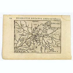
Aniou.
Anjou is a historical province of France, straddling the lower Loire River. Its capital was Angers. It bordered Brittany to the west, Maine to the north, Touraine to the ...
Date: Amsterdam, 1606
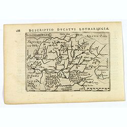
Lotharingia.
Lothringaria (Lorraine) is a historical province of N.E. France, it features the cities of Sarrebourg, Metz, Toul and Nancy. With excellent physical and topographical det...
- $100 / ≈ €87
Date: Amsterdam, 1606
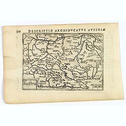
Austria.
A decorative miniature map of the area to the south of Vienna in southern Austria, published by Petrus Bertius in Amsterdam, at the beginning of the seventeenth century. ...
- $100 / ≈ €87
Date: Amsterdam, 1606
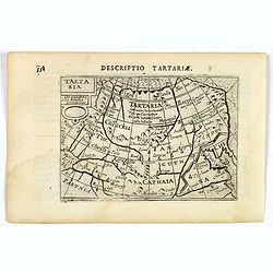
Tartaria.
A fine miniature map showing China, Korea and Russia. Title cartouche on the upper left corner. First published in 1598 in his Caert-Thresoor, the plates were executed by...
- $100 / ≈ €87
Date: Amsterdam, 1606
![Venuxinus Comitatus. [Vaucluse]](/uploads/cache/43427-250x250.jpg)
Venuxinus Comitatus. [Vaucluse]
A pleasant miniature map of the Vaucluse region of S.E. France, as published by Petrus Bertius in Amsterdam at the beginning of the seventeenth century. Many mountains as...
Date: Amsterdam, 1606
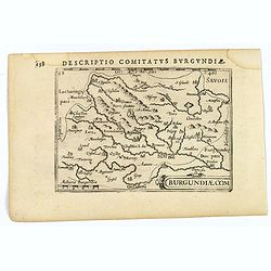
Descriptio Comitatus Burgundiae.
A decorative small map of region around Dijon, Halons and Dole in Burgundy. Features a nice strap-work title, shows rivers and settlements. From the Bertius atlas Tabular...
Date: Amsterdam, 1606
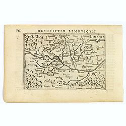
Limania.
A pleasant miniature map of the Limousin region of central France, the area surrounding Clermont Ferrand. Good map detail. From the Bertius atlas Tabularum geographicarum...
Date: Amsterdam, 1606
