Search Listings matching "homann"
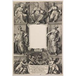
(Title page) Principum Christianorum Stemmata.
Uncommon title page. From Antonio Albizzi, "Principum Christianorum Stemmata ab Antonio Albizio Nobili Florentino collecta: et Cum brevibus ejusdem notationibus ex A...
- $200 / ≈ €173
Date: Strasbourg, 1610
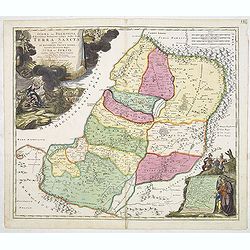
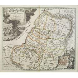
IUDAEA seu PALAESTINA... TERRA SANCTA... IUDA et ISRAEL
Map of Palestine divided among the Tribes, drawn by Homann after Guillaume Sanson. The shoreline runs from Sidon as far as Rinocorura. The Kishon River is shown as connec...
- $500 / ≈ €432
Date: Nuremberg, 1707
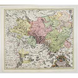
Principatus Isenacensis cum adjacentibus. . .
Detailed map centered on Gotha and Erfurt. Lower right splendid title cartouche.The map is painted in strong colors. Clearly from an show-piece atlas produced for a wealt...
- $200 / ≈ €173
Date: Nurenberg, 1710

Landgraviatus Alsatiae tam superioris..
Alsace, in the far north-eastern corner of France, stands out from other French wine regions thanks to its strong Franco-Germanic influences. Alsace is the only French wi...
Date: Nurenberg, 1710
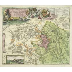
Geographica descriptio Montani cujusdam districtus in ..
Detailed map including the towns of Thurnau, Bayreuth, Culmbach, etc. With fine panoramic view of Thurnau. Upper left and right splendid title cartouches.The map is paint...
Date: Nurenberg, 1710

Tabula Novissima Totius Germaniae praecipue ex designatione viri celeberrimi Dni Johannis Caspari Eisenschmidii…
A very rare large map of Germany plus bordering countries, printed from 4 plates. One of Homann's few wall maps, and one of the most accurate maps of Germany at that time...
Date: Nuremberg, ca. 1711
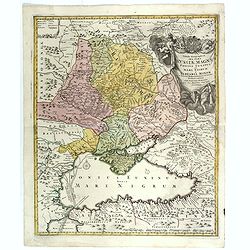
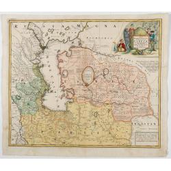
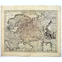
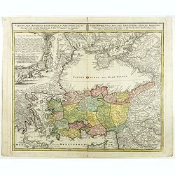
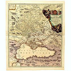
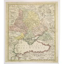
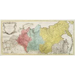
Tabula Geographica qua pars Russiae Magnae. . .
Homann's map is based upon Beauplan's general map of Ukraine but depicts the political changes of the preceding years. With decorative cartouches. Giving good detail alon...
Date: Nuremberg, 1720
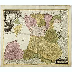
Ducatuum Livoniae et Curlandiae cum vicinis Insulis Nova Exhibitio Geographica. . .
Detailed map of the northern Baltic coast by Homann, pre-dating the privilege.
Date: Nüremberg, 1720
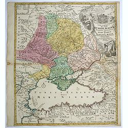
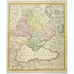
Tabula geographica qua pars Russiae Magnae..
A detailed map of western Russia, depicting the Ukraine, the Black sea, Turkey to the south, Romania and Bulgaria to the south west, Georgia to the east. Shows the cities...
Date: Nuremberg, 1720
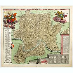
Urbis Romae Veteris ac Modernae Accurata Delineatio. . .
A wonderful 'bird's eye' view of the 'Eternal City' of Rome by Homann, although published in the first quarter of the eighteen century, the map portrays the city at the e...
Date: Nuremberg, ca 1720
Saxoniae Superioris
Impressive title cartouche with miniature panoramic view of Leipzig, coat of arms, putti and Mercury.Johann Baptist Homann born in Kammlach (1663). He was engraver, map-s...
- $150 / ≈ €130
Date: Augsburg, 1720
Nova et accurata Territorii Ulmensis cum dominio Wainensi..
"Showing the area of Ulm. In the lower part, an inset map of the property"zu Wein". Upper right splendid title cartouche.The map is painted in an intense a...
Date: Nurenberg 1720

Tabula Americae Specialis Geographica Regni Peru, Brasiliae, Terra Firmae & Reg: Amazonum, Secundum relationes de Herrera, de Laet & PP d Acuña & M. Rodriguez . . .
A good and clean copy of Homann's map of the northern part of South America. The map is on the Valley of the Amazon and delineates the Amazon and its labyrinth of tributa...
Date: Nuremberg, 1728
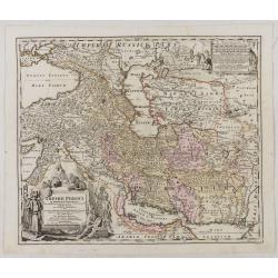
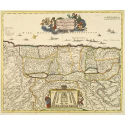
Imperii Persici in omnes suas Provincias . . . Exacte Divisi Nova Tabula Geographica. . .
Showing the eastern part of Turkey and Cyprus, Palestine, Persian Gulf, including Gulf of Oman, Caspian Sea, Iran and the north-west territories of India.Embellished with...
Date: Ausburg, 1730
![[Title page for ] Atlas Novus Terrarum orbis Imperia.](/uploads/cache/47938-250x250.jpg)
[Title page for ] Atlas Novus Terrarum orbis Imperia.
Title page from Atlas Novus printed by Johann Ernst Udelbulner. Large elaborately engraved sheet with numerous allegorical figures. A large globe, showing the Eastern Hem...
Date: Nuremberg, 1732
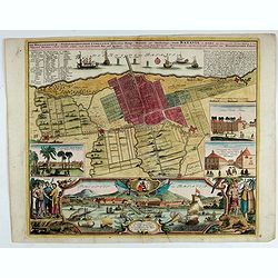
Der Hollaendisch-Ostindianischen Compagnie Weltberühmte Haupt - Handels und Niederlags stadt BATAVIA..
A very fine decorative plan of Batavia showing the City and its immediate environs, the surrounding rice fields intersected by a network of waterways, canals and outlying...
Date: Nuremberg, 1733
Nova Maris Caspii et Regions Usbeck. . .
This is the first printed map specifically of the Uzbek region. It shows the area around the Caspian Sea and northern Iran. The area eastward from the Caspian is marked '...
Date: Nuremberg, 1735
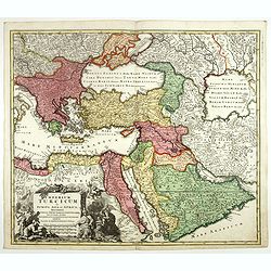
Imperium Turcicum in Europa, Asia et Africa.
Johann Baptist Homann's well-engraved map of the Turkish Empire, showing from Tunis to Arabia, including Greece, Arabia, Turkey and Palestine. With good detail in the Ara...
- $1000 / ≈ €864
Date: Nurnberg, 1737
![[Title page] Atlas Novus Terrarum Orbis Imperia. . .](/uploads/cache/49113-250x250.jpg)
[Title page] Atlas Novus Terrarum Orbis Imperia. . .
The lovely title page from Homann's Grosser Atlas uber de Gantsa Welt (Grand Atlas of all the World)with striking color and features. It shows Atlas and Hercules / Herakl...
Date: Nuremberg, ca 1737
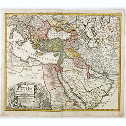
Imperium Turcicum in Europa, Asia et Africa Regiones proprias, tributarias, clientelares sicut et omnes eusdem Beglirbegatus seu Præfecturas Generales exhibens. . .
Johann Baptist Homann's well-engraved map of the Ottoman Empire centered on Cyprus. With good detail in the Arabian Peninsular. In the lower left, a decorative title cart...
- $500 / ≈ €432
Date: Nurnberg, 1737
![[Portrait] Johannes Baptista Homann . . .](/uploads/cache/44363-250x250.jpg)
[Portrait] Johannes Baptista Homann . . .
Stunning full portrait of the Imperial Geographer of the Holy Roman Empire, Johann Baptist Homann (1664-1724) who was born in the Bavarian town of Kammlach. Educated at a...
Date: Nuremberg, c.1740
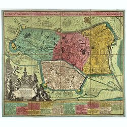
Accurata recens delineata ichnographia celeberrimæ liberæ Imperii civitatis ac Sueviæ metropolis Agustæ Vindelicorum -Neu verfertigt accurater ... Haupt Stadt Augspurg.
Superb plan of the fortified town of Augsburg, brilliantly colored at the time, with title in Latin and German. The plan was designed by Johann Thomas Kraus, engraver, ar...
- $1200 / ≈ €1037
Date: Nuremberg, ca. 1740
Moscoviae seu Russiae Magnae Generalis Tabula. . .
A scarce and attractive, wide-ranging map of incorporating Scandinavia, the Baltic countries, parts of Germany and Czechoslovakia, Poland, Hungary, Ukraine, Bulgaria, Nor...
- $1500 / ≈ €1297
Date: Augsburg, 1740

Paraquariae Provinciae Soc. Iesu cum Adjacentibus Novissima...
Between the years of 1609 and 1780, the Jesuits (the Roman Catholic Society of Jesus) established in South America, an autonomous Christian state, on the lands of present...
Date: Augsburg, 1740
![[Portrait] Johannes Baptista Homann . . .](/uploads/cache/36599-250x250.jpg)
[Portrait] Johannes Baptista Homann . . .
Stunning full portrait of the Imperial Geographer of the Holy Roman Empire, Johann Baptist Homann (1664-1724) who was born in the Bavarian town of Kammlach. Educated at a...
Date: Nuremberg, c.1740

Dominia Anglorum in America Septentrionali.
Four maps on one sheet (New Found land/ New England/ Virginia and Carolina/Florida) based on J.B.Homann's map, showing British possessions in North America. The upper lef...
- $750 / ≈ €648
Date: Nuremberg 1740
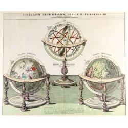
Sphaerarum Artificialium Typica Repraesentatio. . .
Stunning engraving of Homann's terrestrial and celestial globes and armillary sphere, all with highly ornamented stands. Brief explanatory text.Johann Baptist Homann born...
Date: Nuremberg, 1740
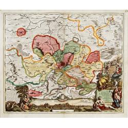
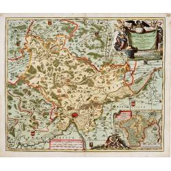
Nova Territorii Erfordien in suas praefecturas..
"Showing the area of Erfurt. In the lower part, there is a panoramic view of the town. Lower left and right splendid cartouches.The cartouches are painted in a stron...
Date: Nurenberg, 1740
Circulus Saxoniae inferioris.
Detailed map of Saxen, including Bremen, Berlin, Lübeck, etc. Johann Baptist Homann (1663-1724) was a German engraver and publisher, who established himself and his fami...
- $200 / ≈ €173
Date: Nuremberg 1740
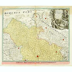
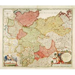
Marchionatus Moraviae circulus brunnensis. . .
Johann Baptist Homann's well-engraved map has a large decorative cartouche. Detailed map centered on Bruenn in Moravia. Prepared by Johann Chr. Mueller. Very decorative t...
- $300 / ≈ €259
Date: Nuremberg, 1740
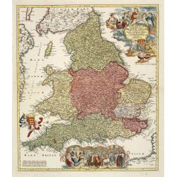
Magnae Britanniae pars meridionalis in qua regnum Angliae. . .
Johann Baptist Homann's well-engraved map has a large decorative cartouche at top right and a large scene at bottom center showing a throned ruler, presumably George I, h...
Date: Nuremberg, 1740
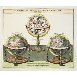
Sphaerarum Artificialium Typica Repraesentatio. . .
Johann Baptist Homann born in Kammlach (1663). He was engraver, map-seller and geographer to the Kaiser of the Holy Roman Empire (1715). He also was member of the Prussia...
- $1300 / ≈ €1124
Date: Nuremberg 1740
Novissima totius Terrae Sanctae sive promissionis. . .
Engraved by J.B.Homann and published by David Funck. One of the very few maps engraved by Johan Baptist Homann, signed lower right.A rare map of the Holy Land, orientated...
- $950 / ≈ €821
Date: Nuremberg, 1742
Carte de l'Asie Minevre ou de la Natolie et du Pont Euxin...
A map centered on the Black Sea and the geographical regions surrounding it. The map shows Asia Minor, Crete, Cyprus, northern Syria, Iraq, Georgia, Crimea, Bulgaria, Rom...
Date: Nuremberg, 1743
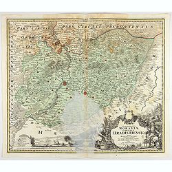
Marchionatus Moraviae circulus Hradistiensis..
Johann Baptist Homann's well-engraved map has a large decorative cartouche. Detailed map centered on Hradisch.Johann Baptist Homann (1663-1724) was a German engraver and ...
Date: Nuremberg 1744

Allerneuester geographisch- und topographischer Schau-Platz von Africa und Ost-Indien. . .
An early issue of this important book by Johann Wolfgang Heydt's describing the Dutch factories, settlements and stations at the hands of the Dutch East India Company in ...
Date: Wilhermsdorf, Tetscher u. Nürnberg, Homanns Erben, 1744
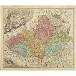
Tabula Generalis Marchionatus Moraviae..
Johann Baptist Homann's well-engraved map has a large decorative cartouche. Detailed map of the historic Moravia region of the Czech Republic, in the present-day Jihormor...
- $275 / ≈ €238
Date: Nuremberg 1744
Judaea seu Palaestina .. Terra Sancta. . .
Johann Baptist Homann's well-engraved map has two large decorative cartouches. Upper left Moses receiving the Tables. Lower right Moses and Aaron pointing at a map showin...
Date: Nuremberg, 1744
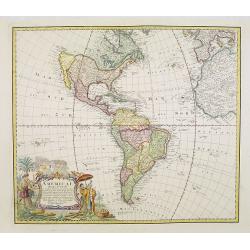
Americae Mappa generalis.
Johann Baptist Homann's well-engraved second map of America has a large decorative cartouche. Detailed map of the western hemisphere.The interior of North America has new...
Date: Nuremberg, 1746
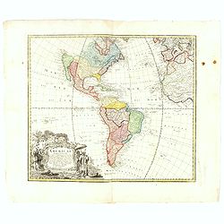
Americae Mappa generalis Secundum legimitas projectionis Stereiographiae regulas. . . MDCCXXXXVI
Johann Baptist Homann's well-engraved second map of America has a large decorative cartouche. Detailed map of the western hemisphere.The interior of North America has new...
- $600 / ≈ €519
Date: Nuremberg, 1746
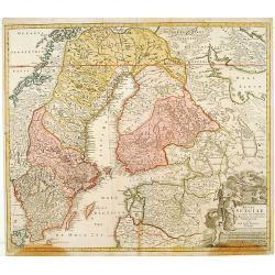
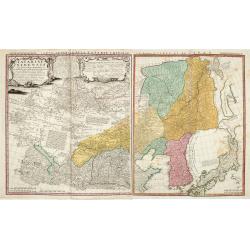
Regni Sueciae. . .
Johann Baptist Homann's well-engraved map has a large decorative cartouche. Detailed map of Sweden and Finland.Johann Baptist Homann (1663-1724) was a German engraver and...
Date: Nuremberg, 1747
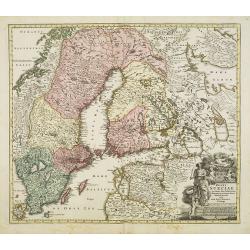
Regni Sueciae in omnes suas Subjacentes Provincias accurate divisi Tabula Generalis. . .
Johann Baptist Homann's well-engraved map has a large decorative cartouche. Detailed map of Scandinavia, the Baltic Sea, Lithuania, Latvia, Estonia, Curlandia, etc.Johann...
Date: Nuremberg, 1747
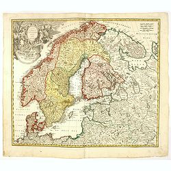
Scandinavia complectens Sueciae, Daniae & Norvegia. . .
Johann Baptist Homann's well-engraved map has a large decorative cartouche. Detailed map of Scandinavia.Johann Baptist Homann (1663-1724) was a German engraver and publis...
- $350 / ≈ €303
Date: Nuremberg, 1747
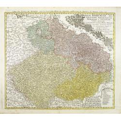
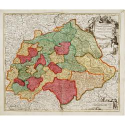
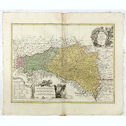
Regni Bohemiae, Duc. Silesiae, Marchionatuum Moraviae et Lusatiae. . .
Johann Baptist Homann's well-engraved map including the towns of Prague, Poznan/ Loda, Wroclaw, etc.This example was printed from plate A (1st of 3), which can be identif...
- $200 / ≈ €173
Date: Nuremberg, ca. 1748
Carte de L'Asie Mineure ou de la Natolie et du Pont Euxin
Johann Baptist Homann's well-engraved map of Asia Minor, the Black Sea ( Ponti Euxin), Crimea and a part of Greece. Depicts Turkey and the area surrounding the Black Sea ...
Date: Nuremberg, ca. 1748
Tartariae Sinensis mappa geographica ex Tabulis specialibus RRPP Iesuitarun nec non Relationibus R.P. Gerbillon / per Dom d'Anville, . . . primum A° 1732 nunc se Nunc secundum LL. projectionis . . . descripta per Tobiam Mayer
A very attractive map of Korea and Manchuria on the mainland and two islands of 'Ezo' and Sakhalin, prepared by Jean-Baptiste Bourguignon d'Anville (1697-1782) and Johann...
- $750 / ≈ €648
Date: Nuremberg, 1749
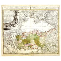
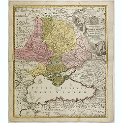
Tabula Geographica qua pars Russiae Magnae Pontus Euxinus seu Mare Nigrum et Tartaria Minor.
Homann's map is based upon the works of George von Mengden (1628-1702) a Livonian cartographer who worked for Peter the Great and Count Jacob Bruce [Graf Jakov Villimovic...
- $750 / ≈ €648
Date: Nuremburg, after 1750
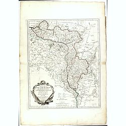
Marchionatus Moraviae circuli Znoymensis et Iglaviensis. . .
Map of the Znaym region of Moravia, the southern part of the Czech Republic, with figurative cartouche and small table of explanations. After Johann Christoph Müller pub...
- $250 / ≈ €216
Date: Nuremberg, 1750
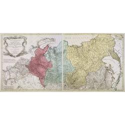
Tabula Geographica qua pars Russiae Magnae. . .
Homann's map is based upon the works of George von Mengden (1628-1702), a Livonian cartographer who worked for Peter the Great and Count Jacob Bruce [Graf Jakov Villimovi...
Date: Nuremburg, after 1750
Tabula Geographica qua pars Russiae Magnae Pontus Euxinus seu mare Nigrum et Tartaria Minor cum finitimis Bulgariae, et Romaniae et Natoliae. . .
Homann's map is based upon Beauplan's general map of Ukraine but depicts the political changes of the preceding years. Shows Constantinople. Extends north to Moscow and S...
Date: Nuremburg, 1750
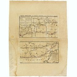
Polnische Reise Karte uber die vornehmsten Passagen von Dresden nach Warschau auf zweyerley Wegen I) uber Breslau, Peterkau und II) uber Lissa, Kaliez . . . 1751
Scarce strip-style road map showing two roads from Dresden via Glogau or Breslau to Warsaw.A key identifies villages, markets and post offices along the routes. Printed i...
Date: Nurember, 1751

Vorstellung Einiger Gegenden und Plaetze in Nord-America unter Franzoesisch und Englische Jurisdiction Gehoerig zu Finden bey den Homaennischen Erben in Nurnberg Ao. 1756.
Three town plans on one sheet of eastern Canada, including Quebec, Louisbourg and Halifax towns which the English and French fought to conquer on the American continent f...
Date: Nuremberg, 1756
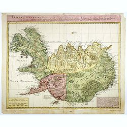
Insulae Islandiae delineatio : prout haec Solenni mensurandi negotio sub Auspiciis Potensissimi Regis Daniae facto . . .
Detailed and important map of Iceland, prepared by Th. H. Knoff and O. Ranzow and published by the Homann Heirs. The map is more scientific than many previous similar ver...
- $850 / ≈ €735
Date: Nuremberg, 1761
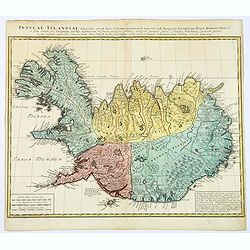
Insula Islandiae delineatio. . .
A nice large map of Iceland published by Homann Heirs. The country is divided up into four differently colored regions, lettered title to top of map, boxed mileage scales...
- $900 / ≈ €778
Date: Nuremberg, 1761
![[Titlepage] Atlas Homannianus Mathematico Historice delineatus.](/uploads/cache/36600-250x250.jpg)
[Titlepage] Atlas Homannianus Mathematico Historice delineatus.
Title page with In the foreground the female figures of Geography, History and Astronomy stand before a large globe, showing the Eastern Hemisphere. Above them the atlas ...
- $350 / ≈ €303
Date: Nuremberg, 1762
Tabula Geographica qua pars Russiae Magnae. . .
An unrecorded state Homann's map is based upon the works of George von Mengden (1628-1702), a Livonian cartographer who worked for Peter the Great and Count Jacob Bruce [...
Date: Nuremberg, c. 1770
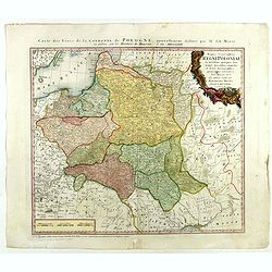
Mappa Geographica Regni Poloniae ex novissimis quot quot sunt mappis. . .
A map of Poland, Lithuania and Belarus, first published in 1750 by Homann Heirs, and now re-issued in 1773. Coastline includes all between Riga and Gdansk. Map is based o...
Date: Nuremberg, 1773
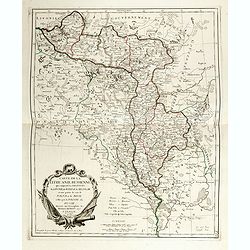
Lubomeriae Et Galliciae Regni Tabula Geographica: Cum Priv. Sac. Caes. Maiestatis Impensis Homannianorum Haeredum . . .
Rare map of the Kingdom of Galicia and Lodomeria prepared by F.L. Güssefeld, (1744-1808), who was a cartographer from Osterburg, studied at Brandenburg, worked in Weimar...
- $1500 / ≈ €1297
Date: Nuremberg, 1775
Carte de la Lithuanie Prussienne qui comprend les Palatinats de Livonie, de Witepsk, de Liscislaw, et une partie de ceux de Polock et de Minsk cédés par la Pologne à la Russie. Dressée sur l'Exemplaire des Héritiers Homann 1775.
Detailed map of the areas along the river Dnieper and Duna. Santini gives credit to Homann Heirs in the cartouche.The map was prepared by the Venetian cartographer and pu...
Date: Venice, 1776

Mappa geographica Provinciæ Nova Eboraci ab Anglis New-York . . .
Lower part of the two sheets map of Homann Heirs' edition of Sauthier's celebrated map of New York and New Jersey, made during the Revolutionary War. Appears in Homann's ...
Date: Nuremburg, 1778

Africa juxta navigationes et observat recentissimas. . .
Miniature map of Africa, a reduction of the Seutter folio map based on Homann''s cartography of 1715. Very detailed - much of it fictitious. The Nile is shown not only or...
Date: Augsburg, J.M.Will, 1778
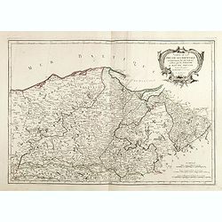
Carte géographique contenant le royaume de Sibérie . . .
Scarce and highly detailed map of Siberia subdivided into three provinces, namely Tobolsk, Jenissejesk, Irkutsk, and outer parts of the Tartary.In upper right corner inse...
Date: Augsburg, c. 1770-1780
Carte géographique contenant le Royaume de Siberie . . .
Very rare and highly detailed map of Siberia subdivided in three provinces, namely Tobolsk, Jenissejesk, Irkutsk, and outer parts of the Tartary. In upper right corner in...
- $800 / ≈ €692
Date: Augsburg, 1770- 1780
Carte de la Lithuanie Russienne qui comprend les Palatinats de Livonie, de Witepsk, de Miscislaw, et une partie de ceux de Polock et de Minsk cédés par la Pologne à la Russie.
Detailed map of the areas along the river Dnieper and Duna. Santini gives credit to Homann Heirs in the cartouche. The map was prepared by the Venetian cartographer and p...
- $500 / ≈ €432
Date: Venice, 1776 - 1784

Carte De La Prusse Occidentale ou sont tracees les Provinces cedees Par la Pologne au Roi De Prusse . . . 1775
Finely and crisply engraved map of Western Prussia, now part of Poland on the Baltic Sea, including the Bay of Danzig. With ornamental title cartouche and noteworthy topo...
Date: Venice, 1776 - 1784

Carte de la Pologne Autrichienne contenant La Russie Rouge et la partie méridionale du Palatinat de Cracovie . . .
Detailed map with Krakow, including the areas of Malopolskie and Podkarpackie and including present-day Ukraine.Santini gives credit to Homann Heirs in the cartouche. Mal...
- $300 / ≈ €259
Date: Venise 1776-1784
Carte De La Prusse Occidentale ou sont tracees les Provinces cedees Par la Pologne au Roi De Prusse . . . 1775
Finely and crisply engraved map of Western Prussia, now part of Poland on the Baltic Sea, including the Bay of Danzig. With ornamental title cartouche and noteworthy topo...
- $375 / ≈ €324
Date: Venice, 1776 - 1784
