Browse Listings in Polar maps

Polus Arcticus cum vicinis regionibus.
1608 MERCATOR, G. / HONDIUS, J. - Rare map of the North Pole, shown as a rocky island surrounded by 'in-drawing seas' between four huge islands
Date: Amsterdam, 1608
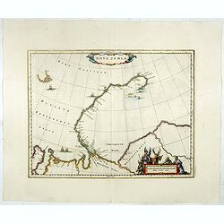
Nova Zemla.
Decorative map decorated with hunters, polar foxes, polar bears and a sea monster.The scalebar in the lower right is in the form of a skewed 'checker-board', to reflect t...
- $900 / ≈ €786
Date: Amsterdam, 1650

Poli Arctici, et circumiacentium terrarum descriptio novissima. . .
A re-issue of the Hondius' plate. A particularly decorative map of the North Pole with Iceland. Several Dutch names in Labrador. The toponymy in Canada reflects the conti...
Date: Amsterdam, 1660
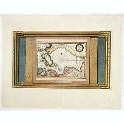
Two polar calottes from a globe.
Two polar calottes from 110 centimeters in diameter globe of 1688 including the northern part of Baffin Bay, Greenland, Iceland, Nova Zembla. Coronelli elected to follow ...
Date: Venice, 1696
La Terre du Nord.
Map of the Arctic Circle, set within a series of decorative borders, printed from a different copper plate. All counties that lie within or near the North Pole are shown ...
Date: Amsterdam, 1713
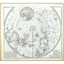
This Draught of the North Pole is to show all the Countries near and adjacent to it . . .
The polar map shows the latest discoveries and routes of numerous explorers during their attempts to find a Northwest and Northeast Passage, including James, Hudson, and ...
- $300 / ≈ €262
Date: London, ca. 1728
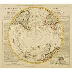
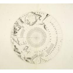
L'Hemisphere Meridional pour voir plus distinctement les Terres Australes.
Decorative map depicting from the southern pole to the Equator with good detail, and showing all the political divisions.Showing South America, southern Africa, the west ...
Date: Amsterdam, c. 1745
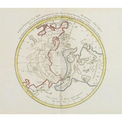
Carte Phisique de la Mer Glaciale Arctique. . .
Very unusual thematic map designed to illustrate the watersheds of the world, after Buache and prepared by J.B.Nolin and published by Monhare for his Atlas Général a l'...
- $300 / ≈ €262
Date: Paris, 1783
![Die Obere oder Nordliche Halbkugel der Erde auf den Horizont von Wien, Sterographisch Entworfen ... [together with] Die Untere oder Sudliche Halbkugel der Erde auf den Horizont von Wien, Stereographisch ...](/uploads/cache/39377-250x250.jpg)
Die Obere oder Nordliche Halbkugel der Erde auf den Horizont von Wien, Sterographisch Entworfen ... [together with] Die Untere oder Sudliche Halbkugel der Erde auf den Horizont von Wien, Stereographisch ...
A set of two uncommon large format maps of the Northern and Southern Hemisphere, based upon the work of Johann Anton Ecker (1755-1820). First published in 1794, this is t...
- $2000 / ≈ €1747
Date: Vienna, Phil. Jos Schalbacher, 1800
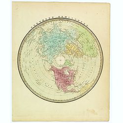
Northern Hemisphere.
A nice map of the northern hemisphere by American cartographer and map publisher, David Burr. The map is centered on the North Pole, and includes all of North America, Eu...
Date: New York, ca 1835
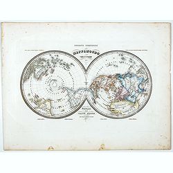
Mappamondo Carta d'Insieme.
Uncommon double hemisphere pole projection prepared by Francesco Costantino Marmocchi. Above the map "Geografia Commerciale". With a color code underneath the m...
Date: Genova, Paolo Rivara fu Giacomo, 1858

Région arctique.
Decorative map of the North Pole, prepared by Louis Vivien de Saint-Martin (* 22. Mai 1802 in Saint-Martin de Fontenay, died 3 January 1897 in Paris). He was one of the m...
Date: Paris, Hachette, 1877
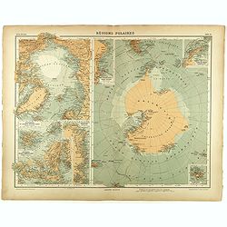
Régions Polaires.
Eight maps on one sheet, showing the North and South Poles, with adjective regions. Taken from "Atlas Universel" by Chesneau and Ch. Bonnesseur. Engraved by R. ...
- $50 / ≈ €44
Date: Paris, 1931
