Browse Listings in Map Types
![[Title page] Les Plans et Profils des principales Villes et lieux considérables Du Duché de Brabant. . .](/uploads/cache/33214-250x250.jpg)
[Title page] Les Plans et Profils des principales Villes et lieux considérables Du Duché de Brabant. . .
Decorative title page from Plans, et Profils des principales villes.. by Ch. De Beaulieu. Etched by mr. Romeijn de Hooghe.
- $80 / ≈ €75
Place & Date: Paris, 1668
![[Title page] Les Plans et Profils des principales Villes et lieux considérables du Comté de Haynaut. . .](/uploads/cache/33216-250x250.jpg)
[Title page] Les Plans et Profils des principales Villes et lieux considérables du Comté de Haynaut. . .
Decorative title page from Plans, et Profils des principales villes.. by Ch. De Beaulieu. Etched by mr. Romeijn de Hooghe.
- $80 / ≈ €75
Place & Date: Paris, 1668
![[Title page] Les Plans et Profils des principales Villes du Comté de Namur. . .](/uploads/cache/33217-250x250.jpg)
[Title page] Les Plans et Profils des principales Villes du Comté de Namur. . .
Decorative title page from Plans, et Profils des principales villes.. by Ch. De Beaulieu. Etched by mr. Romeijn de Hooghe.More about title pages [+]
- $80 / ≈ €75
Place & Date: Paris, 1668
![[Title page] Les Plans et Profils des principales Villes et lieux considérables du Comté de Flandre. . .](/uploads/cache/33218-250x250.jpg)
[Title page] Les Plans et Profils des principales Villes et lieux considérables du Comté de Flandre. . .
Decorative title page from Plans, et Profils des principales villes.. by Ch. De Beaulieu. Etched by mr. Romeijn de Hooghe.
- $80 / ≈ €75
Place & Date: Paris, 1668
![[Title page to] Atlas mayor, o geographia Blaviana : Que contiene las cartas, y descripciones de Partes Orientales de Europa.](/uploads/cache/29952-250x250.jpg)
[Title page to] Atlas mayor, o geographia Blaviana : Que contiene las cartas, y descripciones de Partes Orientales de Europa.
Title page from a Spanish text edition of the Atlas Major. Ionic portico with celestial and terrestrial globes. To the left is Ptolemy with sphere and pair of compasses. ...
- $800 / ≈ €749
Place & Date: Amsterdam, c.1672

.Paskaarte om Achter Yrlandt om te Zeylen van Hitlant tot. . .
An eye-catching chart of Ireland, including the north of England and Scotland, with the West to the top.Pieter Goos (ca. 1616-1675) was one of the most important cartogra...
Place & Date: Amsterdam, 1673
![[Title page from ] Ierusalemsche Reyse.](/uploads/cache/30784-250x250.jpg)
[Title page from ] Ierusalemsche Reyse.
Decorative title page with 2 views of Jerusalem flanked by S. Franciscus and S. Helena. From a very rare travel book by Anthonius Gonsales, "Hierusalemsche Reyse&quo...
- $50 / ≈ €47
Place & Date: Antwerpen, Michiel Cnobbaert, 1673

Tractus Littorales Guineae a Promontorio Verde usque ad sinum Catenbelae.
Chart of the West coast of Africa from Mauritania up to Angola. In top centre a very decorative title cartouche.
Place & Date: Amsterdam, 1675
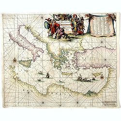
Orientalior districtus Maris Mediterranei.
Beautiful chart of the eastern part of the Mediterranean. Including Italy, the north coast of Africa and part of the Black Sea.The entire sheet is covered with rhumb line...
Place & Date: Amsterdam, 1675

A new mape of Ye XVII Provinces of Low Germanie.
Showing all 17 Provinces of the Netherlands before the split between Spain and the Protestant Provinces under the House of Orange.The map was first published. At the same...
Place & Date: London, 1676
Le jeu des Princes de l'empire d'Allemagne par P. du Val. . .
One of Du Val's magnificent sets of game cards, included in his atlas "Cartes de Geographie".Dated 1674. By the Peace of Westphalia (1648) sovereignty was grant...
- $2000 / ≈ €1871
Place & Date: Paris, 1675-1676

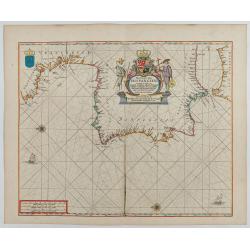
Paskaerte Vande Bocht van Vranckrijk Biscajen en Galissen
An eye-catching chart of Spain and France, including a large part of Brittany, including Isle de Reé , Isle Saint Martin ...Shows the gulf of the northeast Atlantic Ocea...
Place & Date: Amsterdam, 1669-1676
Pas-Caart van Hispangien vertoonde de Custen van Granade…
An eye-catching chart of Spain and Portugal, including a large part of Brittany and the southwestern coast of France, including Isle de Reé , Isle Saint Martin ...Pieter...
Place & Date: Amsterdam, 1669-1676

EUROP, and the cheife Cities contayned therin described. . .
A good impression from an early edition of this famous and decorative "carte à figures"- map from the first world atlas produced by an Englishman - John Speed'...
Place & Date: London, 1627 - 1676
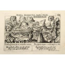
Montaigne de Ca.
In the foreground, a couple of which the man is holding a quadrant with a verse in two languages underneath the picture.The poet and topographer from Comothau, Daniel Mei...
- $85 / ≈ €80
Place & Date: Frankfurt, 1623-1678
![[Title page] Theatri Europaei, oder Beschreibung . . .](/uploads/cache/41395-250x250.jpg)
[Title page] Theatri Europaei, oder Beschreibung . . .
Title page.
- $80 / ≈ €75
Place & Date: Frankfurt, Johann Görlin, 1679
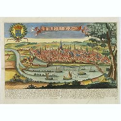
Treves. (Trier)
Rare and decorative view of Tier with the river Meuse in the foreground. Underneath a historical description of the town in Latin and French. The description mentions abo...
- $1000 / ≈ €936
Place & Date: Paris, 1680

The Sea Coast of France from Ushent to Olone.
Chart showing the Brittany coast from Ushent to Ollone, with Belle-Ile. In insets : Rade de Brest and Mouth of the Loire between St. Nazaire and Nantes.Originally engrave...
Place & Date: London, ca. 1680
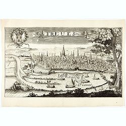
Treves (Trier)
Rare and decorative view of the city of Trier and the river Moselle in the foreground. In the upper left corner the coat of arms of France. The Jollain family was a famil...
- $400 / ≈ €374
Place & Date: Paris, 1680
![[Title page] Atlas Tot Amsterdam Bij Iustus Danckers in de Calverstraet inde Damcbaerhrijt.](/uploads/cache/47920-250x250.jpg)
[Title page] Atlas Tot Amsterdam Bij Iustus Danckers in de Calverstraet inde Damcbaerhrijt.
Decorative title page with the figure of Atlas, standing on a globe of the old world. Left and bottom right corners have animals and people from different parts of the wo...
- $550 / ≈ €515
Place & Date: Amsterdam, ca. 1680

Pas-kaart vande Zee kusten van Venecuela met de Byleggende Eylanden. . .
Rare chart of the coast of Venezuela, including the islands of Curaçao, Bonaire, Aruba, etc.The chart has two insets, one (15x22cm) with a map of Curaçao, one smaller w...
Place & Date: Amsterdam, 1680

The Sea Coasts of France from Olone to Cape Machicaca in Biscay . . .
Detailed chart of Biscay Bay, showing the Coast of Brittany. The chart is oriented with north-east at the top and includes two large insets of the Loire River with Nantes...
Place & Date: London, ca. 1680

Mare Balticum. . . / Nieuwe Pascaert van de Oost Zee. . .
Decorative chart showing the Baltic sea, with a splendid cartouche of royal figures. A re-issue of the De Wit copper plates, now with many improvements.
- $2500 / ≈ €2339
Place & Date: Amsterdam ca.1680

Pascaerte van Carybes, Nieu Neder landt, Brazil. . .
This progenitor chart covers the American shores of the Atlantic Ocean. This chart by Theunis Jacobsz. was most probably engraved close to his death in 1650 or shortly af...
- $2200 / ≈ €2059
Place & Date: Amsterdam, 1653-1681
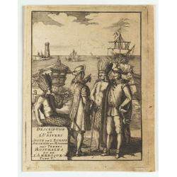
(title page) Description de L'Univers suite de L'Europe ancienne et moderne des terres Australes et de L'Amerique Tome V.
Showing arrival of Francis Drake in the New World.
- $150 / ≈ €140
Place & Date: France, 1683
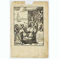
(Title page) Description de L'Univers de l'Europe ancienne et Moderne Tome IV.
Finely etched page from the French text edition of Description d'Univers.. , published in 5 volumes in 1683 by Allain Manneson Mallet (1630-1706), a well travelled milita...
Place & Date: Paris, 1683

Allain Manesson Mallet Pairisi, Ingeni Des Camps Et Armees du Roy de Protugal.
Portrait of Alain Manesson Mallet, engraved by Pierre Landry, from "Description de l'Univers".
- $110 / ≈ €103
Place & Date: Paris, 1683

Pas kaart Van Rio Oronoque Golfo De Paria met d'Eylanden Trinidad, Tabago, Granada, Granadillos, en Bequia . . .
A highly detailed and rare sea chart of the mouth of the Orinoco River, Trinidad, Tabago, St.Vincent and neighboring islands. Oriented with north to the right by two comp...
- $900 / ≈ €842
Place & Date: Amsterdam, 1684
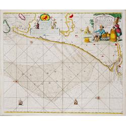
Nieuwe Paskaert van de Kust van HOLLANDT - Tussen Texel en de Maes.
Nieuwe Paskaert van de Kust van Hollandt Tussen Texel en de Maes. A very attractive sea chart off the coast of Holland by Johannes van Keulen with a pair of decorative c...
- $500 / ≈ €468
Place & Date: Amsterdam, ca 1685
(Dedication page Bellona) The Gentleman's Recreation.
Hand-colored allegorical print from Richard Blome's "The Gentleman's Recreation", titled "BELLONA" and dedicated to John Cutts of Arksden.Richard Blom...
- $50 / ≈ €47
Place & Date: London, 1686
![[Title page] Le Nouveau & Grand Illuminant Flambeau de la Mer. La troisième partie. …Par Nicolas Jans Vooght.](/uploads/cache/47950-250x250.jpg)
[Title page] Le Nouveau & Grand Illuminant Flambeau de la Mer. La troisième partie. …Par Nicolas Jans Vooght.
Allegoric frontispiece of the third edition of the "Zee-Fakkel" with French text. The "4" from the date 16"89" is in manuscript.
Place & Date: Amsterdam, 1689
![Teatro Belgico. [Title page ]](/uploads/cache/13992-250x250.jpg)
Teatro Belgico. [Title page ]
Rare tile page from Teatro Belgico, showing an allegory surrounded by court members: on the lower part, seven coats of arm from the Dutch northern provinces.
- $200 / ≈ €187
Place & Date: Amsterdam, 1690

Citta, porto, e rada di Brest, e . . . Nella Bretagna . . .
A beautiful and rare map of Bretagne. In top right an inset with the town of Brest.The remarkable Vincenzo Coronelli (1650-1718), encyclopaedist, geographer, inventor and...
Place & Date: Venice, 1690
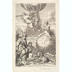
Title page: Atlas Minor sive totius Orbis Terrarum. . .
Finely etched title page from Visscher's Atlas Minor. Showing Atlas supporting the World, and Neptune seated astride a terrestrial globe, showing the Atlantic coasts. Two...
- $400 / ≈ €374
Place & Date: Amsterdam, 1690
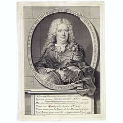
Nicolas Bion Ingenieur du Roy . . .
Copper engraved portrait of Nicolas Bion, engraved by Nicolas II de Larmessin (1632-1694). Bion was a French mathematician and maker of globes and scientific instruments....
- $300 / ≈ €281
Place & Date: Paris, ca. 1690
![[Title page] Isolario.](/uploads/cache/17785-250x250.jpg)
[Title page] Isolario.
Fine title page from Isolario Dell''''Atlante Vento..More about Coronelli. [+]
Place & Date: Venice, 1691
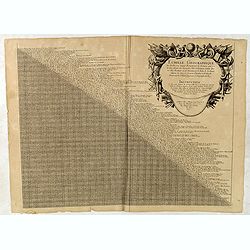
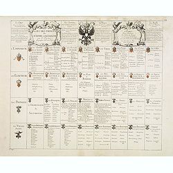
Echelle geographique tres facille pour Sçavoir Promptement la Distance quil y a de line aleautre des Principales Villes et Forteresses. . .
Distance table between French, German, Belgium and Dutch towns. Each place name with a short comment. With large decorative title cartouche with short explanation how to ...
- $90 / ≈ €84
Place & Date: Paris, c. 1691
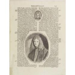
Illustriss et excellentiss D.Paulus Quirini divi Marci procurator.
Fine text page from Isolario Dell'Atlante Vento. with two copper engraved portraits printed within letter press. In top portrait of "Hieronymus Quirinus" (60x55...
Place & Date: Venice, 1691
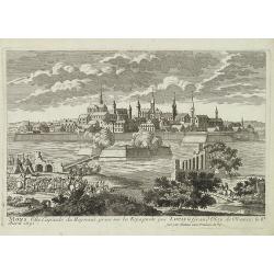
Namur Ville Capitale du Comté de même nom. Elle a este prise par le Roy LOUIS le Grand le 29e Juin 1692.
A very decorative and extremely rare town-view >of Namur, including a numbered key (1-12) in lower part. Engraved by Pierre-Alexandre Aveline. With "fait par Avel...
- $150 / ≈ €140
Place & Date: Paris, ca.1692
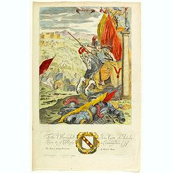
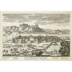
Mons ville capitale du Heynaut, prise sur les Espagnols par Louis le Grand Roy de France. . .
A very decorative and extremely raretown-viewof Mons. Engraved by Pierre-Alexandre Aveline. With "fait par Aveline avec privilege du Roy" in lower right margin....
- $150 / ≈ €140
Place & Date: Paris, ca.1692