Browse Listings in Map Types > Curiosities general
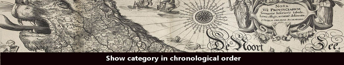
Meerwunder und Seltzame Thier.
A fine detailed woodcut depicting a superb variety of fantastic sea-monsters, such as might be encountered by a sailor in northern waters. Including monsters with abundan...
- $1950 / ≈ €1825
Place & Date: Basel, 1580

Mercurius.
Mercury holding a caduceus and riding in a chariot drawn by two birds on the clouds in the sky, an extensive landscape with a harbor with goods being loaded and unloaded ...
Place & Date: Antwerp, 1585

Lapis polaris magnes.
This is a plate from a series of twenty prints illustrating new inventions and discoveries (Nova Reperta) after Jan van der Straet. On image, bottom right: 'Ion. Stradanu...
Place & Date: Antwerp, Philips Galle, c. 1590
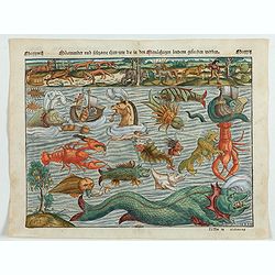
Daniel Meisnerus Comment. Boh. Poeta Laur. Caes.
Very skillfully engraved portrait of Daniel Meisner from a rare work printed by Eberhard Kieser: Thesaurus Philo-Politicus. Das ist Politisches Schatzkästlein guter Herr...
- $200 / ≈ €187
Place & Date: Frankfurt, 1625
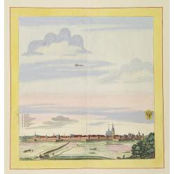
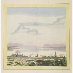
Werben.
Very decorative and rare panoramic town view of Werben a.d. Elbe, Bez. Magdeburg.The engraver and publisher of prints, Mrs. Anna Beek of the Hague, enlarged the print and...
Place & Date: The Hague, ca. 1642
Schweet.
Very decorative and rare panoramic town view of Schwedt a.d Oder, Bez. Frankfurt a.d. Oder.The engraver and publisher of prints, Mrs. Anna Beek of the Hague, enlarged the...
Place & Date: The Hague, ca. 1642

Tabula Anemographica seu Pyxis Nautica.
Impressive compass rose with a fleur de lis at the center and 32 wind directions flowing from it identified in six languages, Greek, Latin, French, Dutch, Italian, and Sp...
Place & Date: Amsterdam, 1650
![[Four cartouche cuttings one sheet]](/uploads/cache/30307-250x250.jpg)
[Four cartouche cuttings one sheet]
Four cut-outs of scale cartouches from Johannes Janssonius plates. Cartouches featuring natives and merchants.
Place & Date: Amsterdam, c.1650

Insula Huaena sive Venusia a Guiljelmo Blaeu cum sub Tychone Astronomiae operam daret, delineata.
Decorative map of the island Hvan in the Danish Sound. In the center Tycho Brahe's famous observatory Uraniborg established in 1576, under the patronage of Frederick II, ...
Place & Date: Amsterdam, 1659

Original copperplate.
Showing the coast of southern Morocco, the Sahara with the Canary Islands. Copperplates that had been used in the production of early maps are of the greatest rarity and ...
Place & Date: Amsterdam, ca. 1660
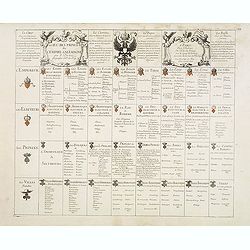
Le jeu des Princes de l'empire d'Allemagne par P. du Val. . .
One of Du Val's magnificent sets of game cards, included in his atlas "Cartes de Geographie".Dated 1674. By the Peace of Westphalia (1648) sovereignty was grant...
- $2000 / ≈ €1871
Place & Date: Paris, 1675-1676
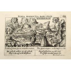
Montaigne de Ca.
In the foreground, a couple of which the man is holding a quadrant with a verse in two languages underneath the picture.The poet and topographer from Comothau, Daniel Mei...
- $85 / ≈ €80
Place & Date: Frankfurt, 1623-1678
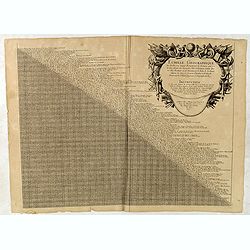
Echelle geographique tres facille pour Sçavoir Promptement la Distance quil y a de line aleautre des Principales Villes et Forteresses. . .
Distance table between French, German, Belgium and Dutch towns. Each place name with a short comment. With large decorative title cartouche with short explanation how to ...
- $90 / ≈ €84
Place & Date: Paris, c. 1691

Schlanium vulgo Schlani Bohemiae oppidum.
Very decorative and rare panoramic town view of Schlan, Schlanium s. Slany.The engraver and publisher of prints, Mrs. Anna Beek of the Hague, enlarged this print, origina...
Place & Date: The Hague, 1700

Launa vulgo Laun Bohemiae civitas.
Bird's-eye views of Louny in Bohemia by G. Hoefnagel. The copperplate was made for Braun and Hogenberg's town book. However there the print has been transformed by the en...
Place & Date: The Hague, 1700
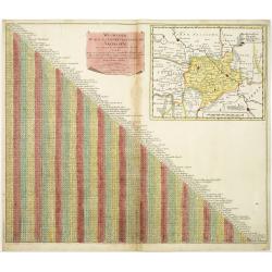
Wegweiser duch das Chiurfurstenthumb Sachen.
Showing distances in-between towns in Saxen, Germany. In upper right hand corner inset map of Saxen, showing Leipzig, Dresden, Prague.More about cartographical curiositie...
- $75 / ≈ €70
Place & Date: Amsterdam 1720

Carte des pavillons accompagnée d'observations pour en faire comprendre le blazon et les différentes devises aussy bien que d'une table alphabétique pour les trouver facilement.?
Map of 88 marine flags, including Malta, Turkey, Middelburg, Amsterdam, Portugal, Monaco, Tuscany, China, Nanking, the French Royal flag, French admiralty flag and mercha...
Place & Date: Amsterdam, 1720

Colossus Monarchic. Statua Danielis
Fantastic double page allegorical map of a colossus figure representing the great world empires as Daniel interpreted in Nebuchadnezzar's dream. The warrior stands stolid...
Place & Date: Augsbourg, 1730
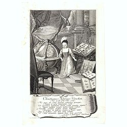
Christianus Henricus Heineken . . .
Portrait of Carl Heinrich, Baron von Heineken, as a child, whole-length, standing on a room with books on the right, a skeleton, and a large globe on the left, wearing a ...
- $300 / ≈ €281
Place & Date: Nuremberg, 1724-1748
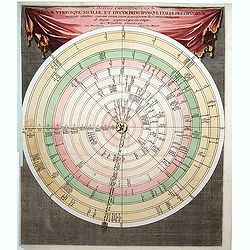
Discus Chronologicus Regum utriusque Siciliae et Ducum Princ
Chronological volvelle table showing the Sicilian rulers from the year 0 until 1730. COMPLETE with its volvelle.
Place & Date: Nuremberg, 1750
![[Double celestial and terrestrial hemisphere]](/uploads/cache/44995-250x250.jpg)
[Double celestial and terrestrial hemisphere]
Small but uncommon double celestial and terrestrial hemisphere. The terrestrial map showing the western hemisphere with an oversized an curious Australian continent.
- $300 / ≈ €281
Place & Date: ca. 1750
(Tableau d'explication des marques, p12)
Key sheet to a rare atlas of the province of Normandy " Atlas de la Province de Normandie dédié à Mr Thiroux de Crosne . . ." dedicated to Mr. Thiroux Crosne...
- $50 / ≈ €47
Place & Date: Paris, 1764

Carta Topografica dell' Isola Del Maritaggio di Monsieur le Boble per la prima volta. Tradotta dal francese in italiano.
Second Italian printing of Eustache Le Noble’s "Carte de l’isle de marriage." The book’s text offers instructions on how to reach this matrimonial island ...
Place & Date: Cosmopoli, 1766

Lion and Bull made of terracotta.
Very fine terracotta figure of a lion symbolizing the continent of Africa. The Bull symbolizing Europe.The items will be dispatched in 4 wooden crates from Belgium. Pleas...
Place & Date: Netherlandisch , 1780~1800

Géographie des Plantes Equinoxiales - Tableau physique des Andes et pays voisins. . .
Physical Portrait of the Andes and adjacent lands", organized around the Chimborazo and Cotopaxi volcanoes in Ecuador.With local vegetation is illustrated pictoriall...
- $1000 / ≈ €936
Place & Date: Paris, 1805
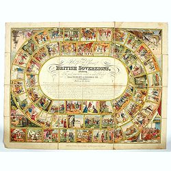
The Royal Game of British Sovereigns Exhibiting the Most Remarkable Events in Each Reign From Egbert to George III,
Engraved goose game with 53 illustrations culminating in a view of Napoleon on the Bellerophon, four further spandrel vignettes, and a central oval filled with title and ...
- $900 / ≈ €842
Place & Date: London, ca. 1817
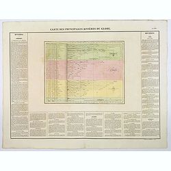
Carte des Principales Riviers du Globe.
A nice detailed depiction of the principal rivers of the world from Buchon's Atlas Gégraphique Statistique, historique et chronologique des deux Ameriques et des isles a...
Place & Date: Paris, 1825
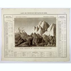
Carte des Principales Montagnes du Globe.
A nice detailed depiction of the principal mountains of the world from Buchon's Atlas Gégraphique Statistique, historique et chronologique des deux Ameriques et des isle...
Place & Date: Paris, 1825
![[Untitled map of the European countries in a playing grid].](/uploads/cache/38460-250x250.jpg)
[Untitled map of the European countries in a playing grid].
Small, accurate lithographed maps of Europe and Asia, embedded in a square playing grid formed by 100 cells.The 11 cells contain the profile of or a reference to a empero...
- $125 / ≈ €117
Place & Date: France, ca. 1850
![[Untitled map of the European countries in a playing grid].](/uploads/cache/36911-250x250.jpg)
[Untitled map of the European countries in a playing grid].
Small, accurate lithographed maps of Europe and Asia, embedded in a square playing grid formed by 100 cells.The 11 cells contain the profile of or a reference to a empero...
- $100 / ≈ €94
Place & Date: France, ca. 1850
![[Untitled map of the European countries in a playing grid].](/uploads/cache/38470-250x250.jpg)
[Untitled map of the European countries in a playing grid].
Small, accurate lithographed maps of Europe and Asia, embedded in a square playing grid formed by 100 cells.The 11 cells contain the profile of or a reference to a empero...
- $110 / ≈ €103
Place & Date: France, ca. 1850
![[Untitled map of the European countries in a playing grid].](/uploads/cache/38464-250x250.jpg)
[Untitled map of the European countries in a playing grid].
Small, accurate lithographed maps of Europe and Asia, embedded in a square playing grid formed by 100 cells.The 11 cells contain the profile of or a reference to a empero...
- $125 / ≈ €117
Place & Date: France, ca. 1850
![[Untitled map of the European countries in a playing grid].](/uploads/cache/37573-250x250.jpg)
[Untitled map of the European countries in a playing grid].
Small, accurate lithographed maps of Europe and Asia, embedded in a square playing grid formed by 100 cells.The 11 cells contain the profile of or a reference to a empero...
- $125 / ≈ €117
Place & Date: France, ca. 1850
![[Untitled map of the European countries in a playing grid].](/uploads/cache/38463-250x250.jpg)
[Untitled map of the European countries in a playing grid].
Small, accurate lithographed maps of Europe and Asia, embedded in a square playing grid formed by 100 cells.The 11 cells contain the profile of or a reference to an emper...
- $125 / ≈ €117
Place & Date: France, ca. 1850
![[Untitled map of the European countries in a playing grid].](/uploads/cache/38462-250x250.jpg)
[Untitled map of the European countries in a playing grid].
Small, accurate lithographed maps of Europe and Asia, embedded in a square playing grid formed by 100 cells.The 11 cells contain the profile of or a reference to an emper...
- $100 / ≈ €94
Place & Date: France, ca. 1850
![[Untitled map of the European countries in a playing grid].](/uploads/cache/38468-250x250.jpg)
[Untitled map of the European countries in a playing grid].
Small, accurate lithographed maps of Europe, embedded in a square playing grid formed by 100 cells.The 11 cells contain the profile or a reference to an Emperors, some ce...
- $100 / ≈ €94
Place & Date: France, ca. 1850
![[Untitled map of the European countries in a playing grid].](/uploads/cache/38461-250x250.jpg)
[Untitled map of the European countries in a playing grid].
Small, accurate lithographed maps of Europe and Asia, embedded in a square playing grid formed by 100 cells.The 11 cells contain the profile of or a reference to a empero...
- $100 / ≈ €94
Place & Date: France, ca. 1850
![[Untitled map of the European countries in a playing grid].](/uploads/cache/38466-250x250.jpg)
[Untitled map of the European countries in a playing grid].
Small, accurate lithographed maps of Europe and Asia, embedded in a square playing grid formed by 100 cells.The 11 cells contain the profile of or a reference to a empero...
- $125 / ≈ €117
Place & Date: France, ca. 1850
![[Untitled map of the European countries in a playing grid].](/uploads/cache/38469-250x250.jpg)
[Untitled map of the European countries in a playing grid].
Small, accurate lithographed map of Europe, embedded in a square playing grid formed by 100 cells.The 11 cells contain the profile of or a reference to Emperors, some cel...
- $100 / ≈ €94
Place & Date: France, ca. 1850
![[Europe depicted as a Queen]](/uploads/cache/41499-250x250.jpg)
[Europe depicted as a Queen]
Among the most striking of early cartographic curiosities is Europe regina or Queen of the world first published by Johannes Bucius' and populized by Sebastian Münster.....
- $450 / ≈ €421
Place & Date: France, ca. 1860