Browse Listings in Europe > Scandinavia > Sweden

De custen van een deel van Denemarken en Swede. . .
A detailed chart of the coast Skane and Kalmar, with the island Öland. Decorated by a title and scale cartouche, a compass rose, several vessels and sea monsters, and dep...
Date: Leiden, Plantijn, 1585
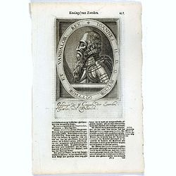
Ioannes II. D.G. Svecior. Gotthor. et Vandalor. Rex.
The engraving depicts a half length oval portrait of "Ioannes II".Nicolaes de Clerck (de Klerc) was active as engraver and publisher in Delft from 1599-1621.Inc...
- $15 / ≈ €13
Date: Amsterdam, Cloppenburch, 1621
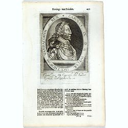
Carolus IX D G Sveciae Gotthorum Vandalorum etc. Rex.
The engraving depicts a half length oval portrait of "Carolus IX".Nicolaes de Clerck (de Klerc) was active as engraver and publisher in Delft from 1599-1621.Inc...
- $15 / ≈ €13
Date: Amsterdam, Cloppenburch, 1621
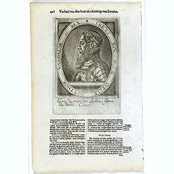
Ericus XIV. D G Sveciae, Gotthor. Vandalor. etc. Rex.
The engraving depicts a half length oval portrait of "Ericus XIV".Nicolaes de Clerck (de Klerc) was active as engraver and publisher in Delft from 1599-1621.Inc...
- $15 / ≈ €13
Date: Amsterdam, Cloppenburch, 1621
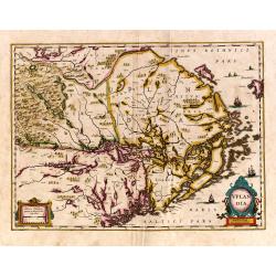
Uplandia.
Covers the area of the modern Uppsala, the vicinity of Stockholm, and includes most of Aland.
Date: Amsterdam, 1639
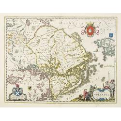
Ducatus Uplandia.
Covers the area of the modern Uppsala land in the vicinity of Stockholm, and includes most of Aland. With a Swedish coat of arms, a figural cartouche with rural people an...
Date: Amsterdam, 1650

Norlandiae et quibies Gestricia et Helsingicae regiones Auct: Andrea Buraeo Sueco.
Uncommon map prepared by Anders Bure (1571-1646) with a dedicational cartouche to Gabriel Bengtsson Oxenstierna.The Atlas Maior is the epitome of decades of achievement b...
Date: Amsterdam, 1662
Die Götha-Elf. Nach Friedr. Akrel's Plancharta öfver Trollhättan reducirt.
Uncommon map prepared by Carl Frederik Akrell. Showing the River Gotha from Gothenburg till Vänersborg.Published by Geographisen Institut in Weimar. A scale in Swedish mi...
Date: Weimar, 1805
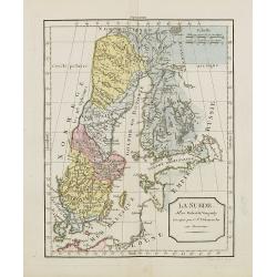
La Suède.
Map of Sweden and Finland. By C. F. Delamarche, successor of Robert de Vaugondy, Geographer.
Date: Paris, ca.1806
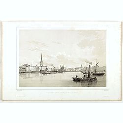
Stockholm, 2e vue en panorama, prise sur le Velar.
Lithography on tinted grounds. View of Stockholm. From "Voyage en Scandinavie, en Laponie, etc" - Atlas Pirtoresque (complément). Designed by A.Mayer and lithog...
Date: Paris, ca 1834-1838
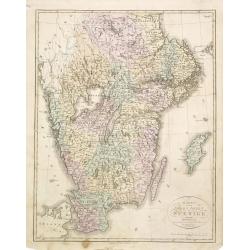
Karta öfver södra delen af Sverige.
An very rare map of Sweden with Swedish text. This is an updated version of his map of 1822 and is now dated 1839. In upper right corner Suppl. 1.From his atlas "Geo...
Date: A. Wiborgs förlag, Stockholm, ca. 1848
