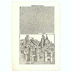
De Polonia Sarmatica - Lituania. CCLXXIX
An imaginary view of a Lithuanian or Polish City (190 x 223mm.) , however the earliest obtainable view of this period.Page from the richest illustrated Incunabula, the fa...
- $400 / ≈ €374
Place & Date: Nuremberg, 12 July 1493
![Sexta Etas Mundi. Bressla. [Breslau or Wrocław] CCXXXIIII.](/uploads/cache/33138-250x250.jpg)
Sexta Etas Mundi. Bressla. [Breslau or Wrocław] CCXXXIIII.
A very fine presentation of the city of Bresslau / Wrocław (230 x 520mm.), in Poland, centered on the cathedral (Dim. : 232 mm W : 520 mm).Overleaf, the kings Wenceslaw ...
Place & Date: Nuremberg, 12 July 1493
![.[Germany and Poland]](/uploads/cache/33862-250x250.jpg)
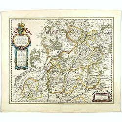
.[Germany and Poland]
Wood block printed map and one of earliest printed representation of Germany, Poland, The Low Countries, Austria and Switzerland prepared by Martin Waldseemüller. Based ...
Place & Date: Vienna, Trechsel, G., 1525 -1541
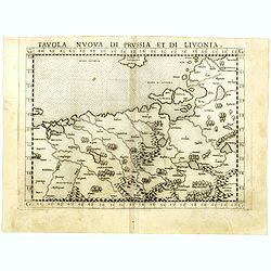
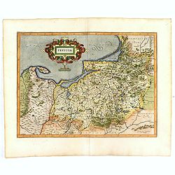
Tavola nuova di Prussia et di Livonia.
Uncommon first edition of this early map of the region from Pomerania to Livonia, includes a portion of Estonia, and coastal detail on the Baltic Sea with a small section...
- $400 / ≈ €374
Place & Date: Venice, Vincenzo Valgrisi, 1561
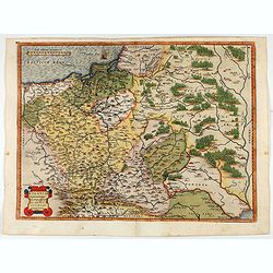
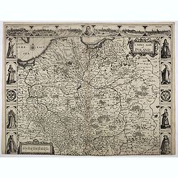
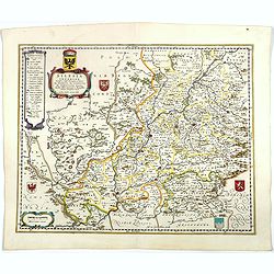
POLONIAE finitimarumque locorum descrip:tio. Auctore WENCESLAO GRODECCIO. Polono.
Ortelius' map of Poland, being a close copy of Grodecki / Pograbka's map of 1558/62 map, itself based on Wapovsky 1526 (Karrow 56) With Latin text on verso, a state 1 and...
- $1200 / ≈ €1123
Place & Date: Antwerp, 1587

POLONIAE finitimarumque locorum descrip:tio. Auctore WENCESLAO GRODECCIO. Polono.
Ortelius' map of Poland, being a close copy of Grodecki / Pograbka's map of 1558/62 map, itself based on Wapovsky 1526 (Karrow 56) With Latin text on verso, a state 4 and...
- $1400 / ≈ €1310
Place & Date: Antwerp, 1592

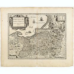
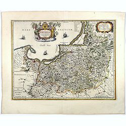
Prussiae Regionis Sarmatiae Europae Nobilissimae Novaet vera descriptio . . .
Nice example of the first edition of De Jode's map of Prussia, from the 1593 edition of De Jode's atlas.The present map is an entirely new addition to the second De Jode ...
- $2000 / ≈ €1871
Place & Date: Antwerp, 1593

Silesiae typus..
Fine and early map of Silesia after Martin Helwig (1516-1574) and used by A.Ortelius in his atlas 'Theatrum Orbis Terrarum [Atlas of the Whole World].Only included in the...
Place & Date: Antwerp, 1598
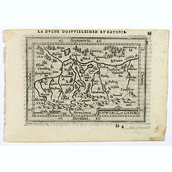
Oswiec. et Zatorien. Ducatus.
Miniature map of Poland from "Il Theatro del Mondo," which was a plagiarized version of Ortelius' pocket atlas published specifically for the Italian market by ...
- $200 / ≈ €187
Place & Date: Brescia, 1598
Oswiecz et Zantor.
An attractive miniature map of Oswieczin and Zator in the Southern part of Poland, with major cities named. Strapwork title cartouche at the bottom. French text on verso....
- $125 / ≈ €117
Place & Date: Antwerp, 1601
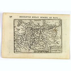
Descriptio Ducat. Ozwiec. et Zato.
An original early 17th century copper engraved miniature antique map of the Oswiecim (Auschwitz) and Zator area of southern Poland by Petrus Bertius. The title is display...
- $100 / ≈ €94
Place & Date: Amsterdam, 1606
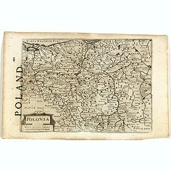
Polonia.
A miniature map of the Polish-Lithuanian Commonwealth, published by Petrus Bertius, in Amsterdam at the beginning of the seventeenth century. It features a small strap-wo...
Place & Date: Amsterdam, 1606
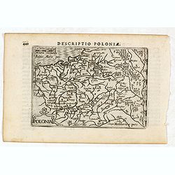
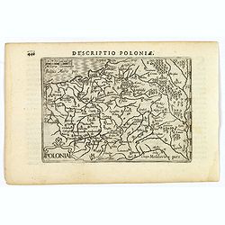
Descriptio Poloniae / Polonia.
A rare miniature map of Poland. Title cartouche on the lower left corner.First published in 1598 in his Caert-Thresoor, the plates were executed by the most famous engrav...
- $400 / ≈ €374
Place & Date: Amsterdam, Cornelis Claes, 1606

Pascaarte van een deel der Oost Zee, tusschen Bornholm ende der Memel, vertonende de ware gelegentheijt der Zeecusten van Pruijssen. . .
This very rare chart of the Northern Coast of Poland with Gdansk, appeared in the rare English edition of Willem Blaeu's 'Het Licht der Zeevaert', an atlas of sea charts ...
- $4000 / ≈ €3743
Place & Date: Amsterdam, 1608

Poloniae, Lituaniaeq descriptio.
Fine general map of Poland. Rare; the second plate appearing in the post-1595 edition of the Theatrum. Only used until 1612.Based on the now-lost map of Waclaw Grodecki. ...
Place & Date: Antwerp, 1612
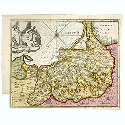
Prussia .
An early map of northern Poland from the "Atlas Minor" (Gerhard Mercator / Jodocus Hondius). Extends from Memel to Torun and the Narew River. With two sailing s...
- $300 / ≈ €281
Place & Date: Amsterdam, 1612
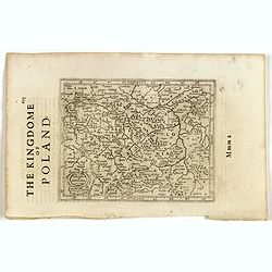
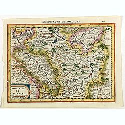
Polonia et Silesia. (With text page)
Early map of Poland. With English title above the map and an description of the region in English on verso.
- $250 / ≈ €234
Place & Date: Amsterdam, 1612
Polonia. (With text page)
Early map of Poland (168x250mm.) printed on a text page, together with another giving a description of the region in English.
- $150 / ≈ €140
Place & Date: Amsterdam, 1612
Prussia .
Important early map showing coast of Baltic Sea in Prussia, today Poland, prepared by the German cartographer Gaspher Henneberg of Erlich. Embellished with a large strapw...
- $600 / ≈ €561
Place & Date: Amsterdam, 1612
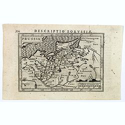
Descriptio Borussiae.
Fine miniature map of Prussia, now-a-day Poland. Bertius was a Flemish theologian, historian, geographer and cartographer. This little copperplate gem was engraved by van...
- $150 / ≈ €140
Place & Date: Amsterdam, 1616

Premislia celebris russiae civitas.
RARE only included in part VI of his town book. Bird's-eye of Przemysl in Poland. Frans Hogenberg (1535 Mechelen - Cologne 1590) was a copper engraver and etcher. Georg B...
Place & Date: Cologne, 1618
Prussiae nova tabula.
Rare map of Prussia with nowadays Poland. The map features a bold title cartouche, a ship, a compass rose, and a sea monster in the Baltic Sea. The map was prepared by th...
- $550 / ≈ €515
Place & Date: London, 1624
A Newe mape of Poland Done into English by I.Speede.
A wonderful map of Poland. Incorporated into Speed's 'Prospect Of The Most Famous Parts Of The World'. Includes birds-eye views of Cracow, Dantzick, Posna, Crossen, Sando...
- $3500 / ≈ €3275
Place & Date: London, 1627

A Newe mape of Poland Done into English by I.Speede.
A wonderful map of Poland. Incorporated into Speed's 'Prospect Of The Most Famous Parts Of The World.' Includes birds-eye views of Cracow, Dantzick, Posna, Crossen, Sando...
Place & Date: London, 1627
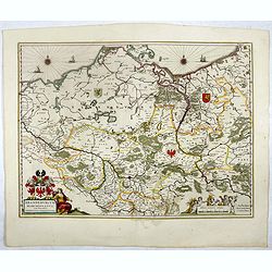
![Tabula electoratus Brandenburgici, Meckelenburgi, et maximae partis Pomeraniae, ex variis, famosissimisq[ue] auctoribus summo studio concinnata. . .](/uploads/cache/37545-250x250.jpg)
Tabula electoratus Brandenburgici, Meckelenburgi, et maximae partis Pomeraniae, ex variis, famosissimisq[ue] auctoribus summo studio concinnata. . .
Uncommon "carte à figures"- map engraved by the master engraver Abraham Goos and published by Claes Jansz. Visscher (1587-1652). Showing the part of western Po...
Place & Date: Amsterdam, 1630
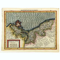
Pomeraniae Ducatus.
Pomerania map from the rare Cloppenburg edition slightly larger format and more scarce edition of the Mercator/Hondius "Atlas Minor". Small and detailed map of ...
Place & Date: Amsterdam, 1630

Tabula nova Poloniae et Silesiae.
Second state, dated 1630 underneath the title. A finely engraved carte á figures with cartouche representing in the four corners of the map : Kings ( on the left side Si...
Place & Date: Amsterdam, 1630
Polonia et Silesia.
Map of Poland and Silesia from the rare Cloppenburg edition slightly larger format and more scarce edition of the Mercator/Hondius "Atlas Minor". Engraved by Pi...
Place & Date: Amsterdam, 1630
Prussiae nova tabula.
The map features a bold title cartouche, a ship, compass rose and a sea monster in the Baltic Sea. As indicated in the title cartouche, the map was prepared by the German...
Place & Date: Amsterdam, 1634
Selling price: $80
Sold in 2015

Polonia regnum et Silesia ducatus.
Very decorative map of Poland embellished with two cartouches and two coats of arms surmounted by cherubs and female figures. Showing the region from the Oder east to Pod...
Place & Date: Amsterdam, 1638
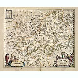
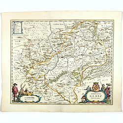
Comitatus Glatz.
Handsome map of the Silesia region with Glatz (Klodzko) at center. The forested region was renowned for its wild game and the map includes tiny illustrations of the wildl...
- $450 / ≈ €421
Place & Date: Amsterdam, 1640
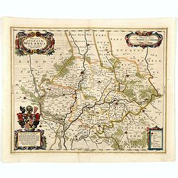
Ducatus silasiae Wolanus. . .
An engraved 17th-century map of the Duchy of Wohlau in Poland with four cartouches in the corners. Orientated with east at the top. The decorative cartouche displaying th...
- $550 / ≈ €515
Place & Date: Amsterdam, ca. 1641
Ducatus Silesiae Glogani Vera Delineatio . . .
Map of Silesia showing the area of Glogow. French text on back. More about Willem Blaeu. [+]
- $350 / ≈ €328
Place & Date: Amsterdam, 1644
Prussia accurate descriptia a Gasparo Henneberg Erlichensi.
Prussia and the Baltic Region, with two large decorative cartouches, coat of arms, and three sailing ships. As indicated in the title cartouche, the map was prepared by t...
Place & Date: Amsterdam, 1644
Selling price: $500
Sold in 2017
Silesia Inferior. . .
Decorative map prepared by Jonas Scultetus, a Silesian cartographer (1603-1664). More about Willem Blaeu. [+]
- $300 / ≈ €281
Place & Date: Amsterdam, 1644
Comitatus Glatz.
Nice map by Willem Blaeu of the Silesia region with Glatz (Klodzko) at center. The forested region was renowned for its wild game and the map includes tiny illustrations ...
- $450 / ≈ €421
Place & Date: Amsterdam, 1644
Brandeburgum Marchionatus. . .
Decorative map by Willem Blaeu centered on Berlin and Brandenburg, and part of Poland and Pomerania, Mecklenburg and Rugia with excellent detail of forests, rivers, towns...
- $250 / ≈ €234
Place & Date: Amsterdam, 1644
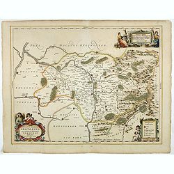
Ducatus Silesiae Glosani.
Charming map of the Silesia from the Mercator Hondius “Atlas Minor” published in Amsterdam in 1648 at Janssonius with German text on verso. Engraved by Petrus Kaerius...
- $200 / ≈ €187
Place & Date: Amsterdam, 1648
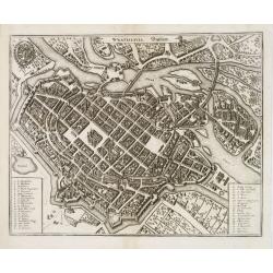
Wratislavia. Bresslaw.
Decorative town-plan of the Polish city of Wroclaw, once known as Breslau. The engraving is by the famed Swiss engraver Matthew Merian. A numbered key (1 - 38) the corner...
- $600 / ≈ €561
Place & Date: Frankfurt, ca. 1649
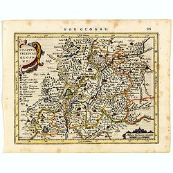
Ducatus Silesiae Grotganus cum Districtu Episcopali Nissensi Delineatore Iona Sculteto, Silesio.
Attractive engraved map of Upper Silesia prepared by Joanus Scultetus, a Silesian cartographer (1603-1664) and published by J. Janssonius. Showing the area around Nysa an...
- $400 / ≈ €374
Place & Date: Amsterdam, 1650