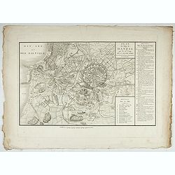
Accueil Consultation Plan du Siège de Danzig par le 10me. Corps de la Grande Armée, Avec les travaux des Français, tels qu'ils étaient le 25 Avril 1807.
A map of the siege of Danzig, 19 March-24 May 1807, showing the positions of the French siege works as they stood on 23 April. Napoleonic Wars (1803-15). Oriented with so...
Place & Date: Paris, after 1810
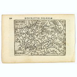
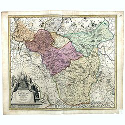
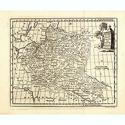
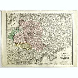
Polonia.
A miniature map of the Polish-Lithuanian Commonwealth, published by Petrus Bertius, in Amsterdam at the beginning of the seventeenth century. It features a small strap-wo...
Place & Date: Amsterdam, 1606
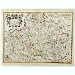
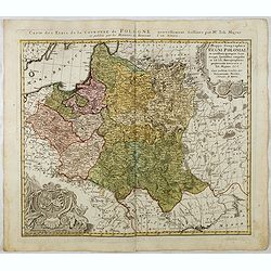
Estats De La Couronne De Pologne ou sont les Royaume de Pologne, Duches et Provinces De Prusse, Cuiave, Mazovie, Russie Noire &c.
Fine map of Poland, state with erased date. Engraved by J.Sommer.Nicolas Sanson was to bring about the rise of French cartography, although the fierce competition of the ...
Place & Date: Paris, 1663
Estats de la Couronne de Pologne.
Map of Poland prepared by N.Sanson and published by F. Halma.Published in an Dutch edition of the small Sanson atlas L'Europe Dediée a Monseigneur . . . Le Tellier Secre...
Place & Date: Amsterdam, Utrecht, 1683
Regni Poloniae, ducatus Mazoviae et province Cujaviae / descriptio emendata per R. & I. Ottens
Very rare map of Poland Lithuania and Ukraine, etc. Engraved by A. Schut.Joachim Ottens (1663 - 1719) and his sons Renier and Joshua were prominent Dutch booksellers and ...
Place & Date: Amsterdam, 1725
Selling price: $1500
Sold in 2017
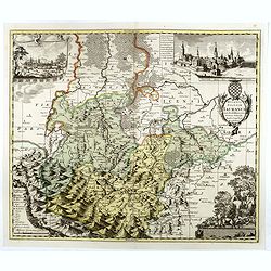
Polonia et Silesia.
Map of Poland and Silesia from the rare Cloppenburg edition slightly larger format and more scarce edition of the Mercator/Hondius "Atlas Minor". Engraved by Pi...
Place & Date: Amsterdam, 1630
Pomeraniae Ducatus.
Pomerania map from the rare Cloppenburg edition slightly larger format and more scarce edition of the Mercator/Hondius "Atlas Minor". Small and detailed map of ...
Place & Date: Amsterdam, 1630
Poland As Divided.
This map covers Poland following Napoleonic Wars and the treaties of the 1815 Congress of Vienna.This map was first published in Thomson's New General Atlas of 1814. John...
Place & Date: Edinburgh, 1817
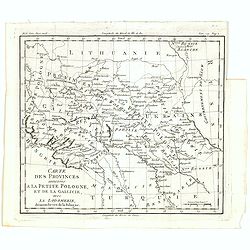
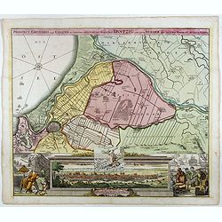
Carte des provinces annexées à la petite Pologne, et de la Gallicie, avec la Lodomerie, démembrées de la Pologne.
A map of the southern provinces of Poland by Louis Brion de la Tour, from the work "Histoire universelle depuis le commencement du monde jusqu a present" publis...
Place & Date: Paris, 1779
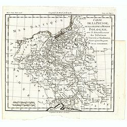
Carte de la Prusse, de la Grande et Petite Pologne, avec le démembrement des Palatinats de Cracovie et Sandomirz, faisant aujour d'hui partie de la Lodomerie.
A map of the Polish territories by Louis Brion de la Tour, from the work "Histoire universelle depuis le commencement du monde jusqu a present" published in Par...
Place & Date: Paris, 1779
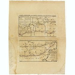
Polnische Reise Karte uber die vornehmsten Passagen von Dresden nach Warschau auf zweyerley Wegen I) uber Breslau, Peterkau und II) uber Lissa, Kaliez . . . 1751
Scarce strip-style road map showing two roads from Dresden via Glogau or Breslau to Warsaw.A key identifies villages, markets and post offices along the routes. Printed i...
Place & Date: Nurember, 1751

Silesiae typus..
Fine and early map of Silesia after Martin Helwig (1516-1574) and used by A.Ortelius in his atlas 'Theatrum Orbis Terrarum [Atlas of the Whole World].Only included in the...
Place & Date: Antwerp, 1598
![Sexta Etas Mundi. Bressla. [Breslau or Wrocław] CCXXXIIII.](/uploads/cache/33138-250x250.jpg)
Sexta Etas Mundi. Bressla. [Breslau or Wrocław] CCXXXIIII.
A very fine presentation of the city of Bresslau / Wrocław (230 x 520mm.), in Poland, centered on the cathedral (Dim. : 232 mm W : 520 mm).Overleaf, the kings Wenceslaw ...
Place & Date: Nuremberg, 12 July 1493
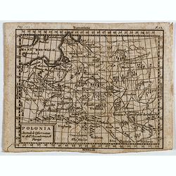
Polonia secondo le obzervazioni dell'accademiadi Parigi.
Uncommon Italian map of present day Poland and Lithuania prepared by Claude Buffier was a Jesuit theologian and geographer working in Paris, who wrote the Geographie Univ...
- $150 / ≈ €140
Place & Date: Naples, Rome, ca. 1725
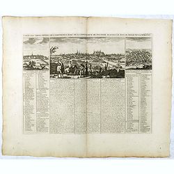
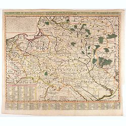
Carte Des Trois Ordres Qui Composent L'Etat De La Republique De Pologne...
Decorative views of Cracow, Warsaw and Vilna, from Chatelain's monumental Atlas Historique.Zacharie Chatelain (d.1723) was the father of Henri Abraham (1684-1743) and Zac...
- $600 / ≈ €561
Place & Date: Paris, 1732
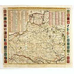
Le Royaume De Pologne, divise selon les Partages faits en 1772, 1793 et 1795, etnre la Russie, la Prusse et l'Autriche . . .
The uncommon later edition of this detailed map of Poland, showing the lands lost to Russia, Prussia and Austria in 1772, 1793 and 1795. with a color key added underneath...
- $600 / ≈ €561
Place & Date: Paris, ca. 1796
Mappa Geographica Regni Poloniae ex novissimis quotquot sunt mappis specialibus composita et al L.L. Stereographicae projectionis revocata a Tob. Mayero. . . .
Decorative map of Poland after Tobias Mayer who was based on Barnikel's map of Curland (1747) and Jan Nieprzecki's map of Lithuania (1749).Poland extends from Glogau and ...
- $600 / ≈ €561
Place & Date: Nuremberg, 1757
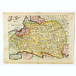
La Prusse divisée en Prusse Royale et Prusse Ducale.
The map extends from Memem, Danzig and Rosienne in the North to Novigrod in the southeast and Thorn on the Wessel in the southwest. Shows the Gulf of Danzig and part of P...
- $200 / ≈ €187
Place & Date: Venice, 1776 - 1784
Poland Lithuania and Prussia.
Uncommon miniature map of Poland, Lithuania and the Ukraine, engraved by Thomas Kitchin - with his signature in lower right bottom.
- $300 / ≈ €281
Place & Date: London, 1782
Ducatus Silesiae Iauranus. Aut : Frid : Kühnovio. . .
Rare Pieter Schenk edition of Friedrich Kubn's (Kühnovio) map of Jawor in southwest Poland based on Johann Gottfried Bartsch, map first published in Świdnica (then Schw...
Place & Date: Amsterdam, 1700-1725
Selling price: $1250
Sold in 2017
Prospect, Grundriss und Gegend der Polnischen vesten Reichs und Handels-Stadt Dantzig und ihrem Werder. . .
Striking example of Homann's map of Danzig (Gdansk) and neighboring regions and striking birds eye view, major port to the Baltic Ocean, which for centuries was an import...
- $550 / ≈ €515
Place & Date: Nuremberg, ca. 1720
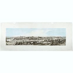
Widok Krakowa od Podgonza.
Bird's-eye view of Krakow city, with underneath the names of thirteen important buildings. Lithographed by J.Brydak after a photo by W. Rzewuskriego. Published by Czasu W...
- $750 / ≈ €702
Place & Date: Krakow, ca. 1865
Carta del Teatro della Guerra in Polonia - 1831.
Oversized rare 1831 war map of Poland and Lithuania published during the Polish - Russian War in 1831, published by Presso l'incisore Stanislao Stucchi. Stucchi, was born...
- $900 / ≈ €842
Place & Date: Milan, 1831
Part of Prussia.
Attractive example of the scarce 1828 Malte-Brun map of modern day Poland and Lithuania. Published by Samuel Walker in 1828 as part of the American edition of Conrad Malt...
- $100 / ≈ €94
Place & Date: Boston, 1828

Carte De La Prusse Occidentale ou sont tracees les Provinces cedees Par la Pologne au Roi De Prusse . . . 1775
Finely and crisply engraved map of Western Prussia, now part of Poland on the Baltic Sea, including the Bay of Danzig. With ornamental title cartouche and noteworthy topo...
- $250 / ≈ €234
Place & Date: Venice, 1776 - 1784
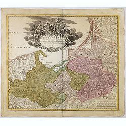
Regnum Borussiae gloriosis auspicijs Seerenissimi et Potentissimi Princip Friderici III Primi . . .
Map covering the region along the Baltic Sea from Prussia, Memel, to northern Poland, extending south to Poland, centered on Danzig, Konigsberg, Heilsperg, etc. Beautiful...
- $350 / ≈ €328
Place & Date: Nuremberg, 1720
![Partie septentrionale du cercle de Haute Saxe [...] Brandebourg.](/uploads/cache/33211-250x250.jpg)
Partie septentrionale du cercle de Haute Saxe [...] Brandebourg.
Finely and crisply engraved map of north eastern part of Germany, including part of Poland. With inset map of Brandenburg. Map by Giles Didier Robert De Vaugondy with era...
- $150 / ≈ €140
Place & Date: Paris, c. 1760
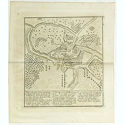
Plan von der Stadt Pullusk alwo der Konig von Sweden Carl XII den Saxischen Feldmarschall Steinau. . .
Rare plan of the Battle of Pultusk which took place on April 21, 1703 in Pultusk during the Great Northern War. The Swedish army under the command of Charles XII defeated...
- $450 / ≈ €421
Place & Date: Frakfurt, Merian heirs,1717
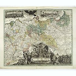
Generale Carte der gesamten Koniglichen Preussischen Lander. . .
Beautiful and rare two-sheet map of Prussia with part of now-a-days Poland. The title cartouche is hold by a crowned eagle. In lower part a large baroque cartouche with a...
- $3000 / ≈ €2807
Place & Date: Berlin, 1760
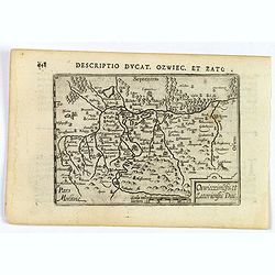
Descriptio Ducat. Ozwiec. et Zato.
An original early 17th century copper engraved miniature antique map of the Oswiecim (Auschwitz) and Zator area of southern Poland by Petrus Bertius. The title is display...
- $100 / ≈ €94
Place & Date: Amsterdam, 1606
Carte De Pologne Avec La Chronologie Des Rois Et Des Ducs De Lithuanie, Ainsi Que Des Grands M. De L'Ordre Teutonique Les Evechez et Archeveches, et Les Armes Des Provinces . . .
Map of Poland with a key table to the towns, and 30 coats of arms on both sides, extending south the Black Sea. From Chatelain's monumental 7-volume "Atlas Historiqu...
- $1750 / ≈ €1638
Place & Date: Amsterdam, 1720

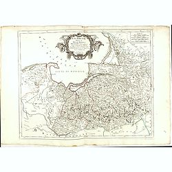
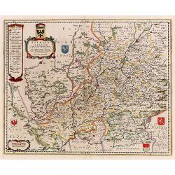
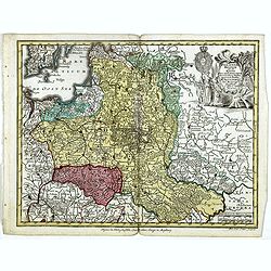
Carte de la Pologne Autrichienne contenant La Russie Rouge et la partie méridionale du Palatinat de Cracovie . . .
Detailed map with Krakow, including the areas of Malopolskie and Podkarpackie and including present-day Ukraine.Santini gives credit to Homann Heirs in the cartouche. Mal...
- $300 / ≈ €281
Place & Date: Venise 1776-1784
Silesia Inferior..
Decorative map prepared by Jonas Scultetus, a Silesian cartographer (1603-1664).
- $400 / ≈ €374
Place & Date: Amsterdam, 1650
Nouvelle carte du royaume de Pologne, divisée selon..
Chatelain's map of Poland. The title is in two lines across the map. On bottom border appears an index to the map's contents. At the top of the map appear historical rema...
- $1100 / ≈ €1029
Place & Date: Amsterdam, 1719
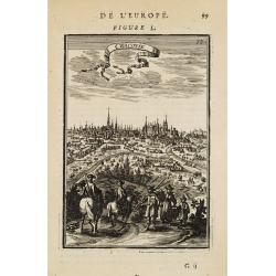
Cracovie.
View of Cracow. From the French text edition of Description d'Univers... By Allain Manneson Mallet (1630-1706), a well travelled military engineer and geographer who work...
- $300 / ≈ €281
Place & Date: Paris, 1683

Prussiae Regionis Sarmatiae Europae Nobilissimae Novaet vera descriptio . . .
Nice example of the first edition of De Jode's map of Prussia, from the 1593 edition of De Jode's atlas.The present map is an entirely new addition to the second De Jode ...
- $2000 / ≈ €1871
Place & Date: Antwerp, 1593
Polonia regnum ut et magni Ducat Lithuania. . .
Miniature map of Poland, a reduction of the appropriate part of Seutter's folio map. Engraved by Tobias Conrad Lotter.From Atlas Minor, here published by Johann Martin Wi...
- $450 / ≈ €421
Place & Date: Augsburg, J.M.Will, 1778
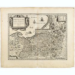
Prussiae nova tabula.
The map features a bold title cartouche, a ship, compass rose and a sea monster in the Baltic Sea. As indicated in the title cartouche, the map was prepared by the German...
Place & Date: Amsterdam, 1634
Selling price: $80
Sold in 2015
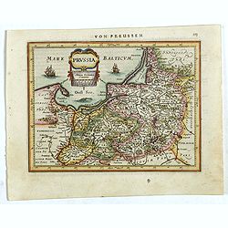
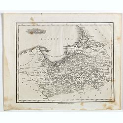
Prussia .
An early map of northern Poland from the "Atlas Minor" (Gerhard Mercator / Jodocus Hondius). Extends from Memel to Torun and the Narew River. With two sailing s...
- $300 / ≈ €281
Place & Date: Amsterdam, 1612
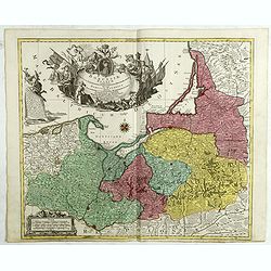
Borussiae Regnum compectens Circulos Sambiensem, Natangiensem, et Hockerlandiae Nee non Borussia Polonica, exhibens Palatinatus Culmiensem. . .
Decorative map covering northern Poland with Prussia, Pomerania, Hockerlandia, Warmiaermelandia, Natanglensis, Galindia, Nandrovia, Sclavonia, and the Baltic Sea. Include...
- $400 / ≈ €374
Place & Date: Augsburg, 1759