
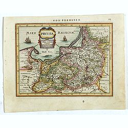
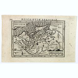
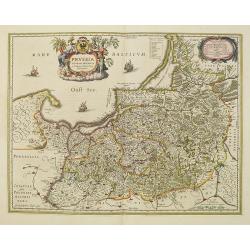
Prussiae Regionis Sarmatiae Europae Nobilissimae Novaet vera descriptio . . .
Nice example of the first edition of De Jode's map of Prussia, from the 1593 edition of De Jode's atlas.The present map is an entirely new addition to the second De Jode ...
- $2000 / ≈ €1871
Place & Date: Antwerp, 1593

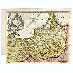
Silesiae typus..
Fine and early map of Silesia after Martin Helwig (1516-1574) and used by A.Ortelius in his atlas 'Theatrum Orbis Terrarum [Atlas of the Whole World].Only included in the...
Place & Date: Antwerp, 1598
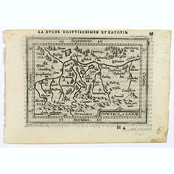
Oswiecz et Zantor.
An attractive miniature map of Oswieczin and Zator in the Southern part of Poland, with major cities named. Strapwork title cartouche at the bottom. French text on verso....
- $125 / ≈ €117
Place & Date: Antwerp, 1601
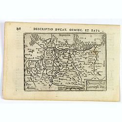
Descriptio Ducat. Ozwiec. et Zato.
An original early 17th century copper engraved miniature antique map of the Oswiecim (Auschwitz) and Zator area of southern Poland by Petrus Bertius. The title is display...
- $100 / ≈ €94
Place & Date: Amsterdam, 1606

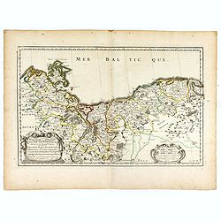
Pascaarte van een deel der Oost Zee, tusschen Bornholm ende der Memel, vertonende de ware gelegentheijt der Zeecusten van Pruijssen. . .
This very rare chart of the Northern Coast of Poland with Gdansk, appeared in the rare English edition of Willem Blaeu's 'Het Licht der Zeevaert', an atlas of sea charts ...
- $4000 / ≈ €3743
Place & Date: Amsterdam, 1608
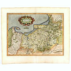
Prussia .
An early map of northern Poland from the "Atlas Minor" (Gerhard Mercator / Jodocus Hondius). Extends from Memel to Torun and the Narew River. With two sailing s...
- $300 / ≈ €281
Place & Date: Amsterdam, 1612
Prussia .
Important early map showing coast of Baltic Sea in Prussia, today Poland, prepared by the German cartographer Gaspher Henneberg of Erlich. Embellished with a large strapw...
- $600 / ≈ €561
Place & Date: Amsterdam, 1612
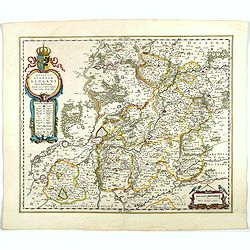
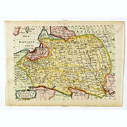
Descriptio Borussiae.
Fine miniature map of Prussia, now-a-day Poland. Bertius was a Flemish theologian, historian, geographer and cartographer. This little copperplate gem was engraved by van...
- $150 / ≈ €140
Place & Date: Amsterdam, 1616
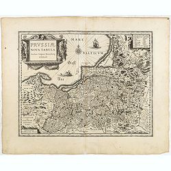
Prussiae nova tabula.
Rare map of Prussia with nowadays Poland. The map features a bold title cartouche, a ship, a compass rose, and a sea monster in the Baltic Sea. The map was prepared by th...
- $550 / ≈ €515
Place & Date: London, 1624
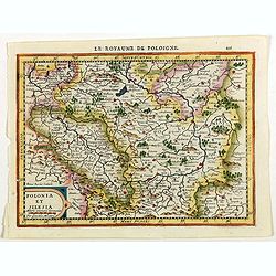
Polonia et Silesia.
Map of Poland and Silesia from the rare Cloppenburg edition slightly larger format and more scarce edition of the Mercator/Hondius "Atlas Minor". Engraved by Pi...
Place & Date: Amsterdam, 1630
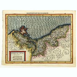
Pomeraniae Ducatus.
Pomerania map from the rare Cloppenburg edition slightly larger format and more scarce edition of the Mercator/Hondius "Atlas Minor". Small and detailed map of ...
Place & Date: Amsterdam, 1630
![Tabula electoratus Brandenburgici, Meckelenburgi, et maximae partis Pomeraniae, ex variis, famosissimisq[ue] auctoribus summo studio concinnata. . .](/uploads/cache/37545-250x250.jpg)
Tabula electoratus Brandenburgici, Meckelenburgi, et maximae partis Pomeraniae, ex variis, famosissimisq[ue] auctoribus summo studio concinnata. . .
Uncommon "carte à figures"- map engraved by the master engraver Abraham Goos and published by Claes Jansz. Visscher (1587-1652). Showing the part of western Po...
Place & Date: Amsterdam, 1630
Prussiae nova tabula.
The map features a bold title cartouche, a ship, compass rose and a sea monster in the Baltic Sea. As indicated in the title cartouche, the map was prepared by the German...
Place & Date: Amsterdam, 1634
Selling price: $80
Sold in 2015
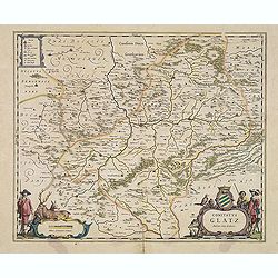
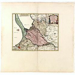
Comitatus Glatz.
Handsome map of the Silesia region with Glatz (Klodzko) at center. The forested region was renowned for its wild game and the map includes tiny illustrations of the wildl...
- $450 / ≈ €421
Place & Date: Amsterdam, 1640
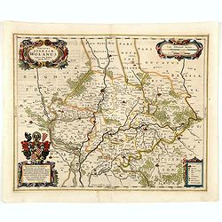
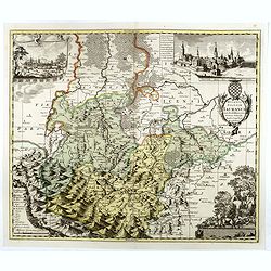
Ducatus silasiae Wolanus. . .
An engraved 17th-century map of the Duchy of Wohlau in Poland with four cartouches in the corners. Orientated with east at the top. The decorative cartouche displaying th...
- $550 / ≈ €515
Place & Date: Amsterdam, ca. 1641
Ducatus Silesiae Glogani Vera Delineatio . . .
Map of Silesia showing the area of Glogow. French text on back. More about Willem Blaeu. [+]
- $350 / ≈ €328
Place & Date: Amsterdam, 1644
Silesia Inferior. . .
Decorative map prepared by Jonas Scultetus, a Silesian cartographer (1603-1664). More about Willem Blaeu. [+]
- $300 / ≈ €281
Place & Date: Amsterdam, 1644
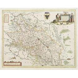
Comitatus Glatz.
Nice map by Willem Blaeu of the Silesia region with Glatz (Klodzko) at center. The forested region was renowned for its wild game and the map includes tiny illustrations ...
- $450 / ≈ €421
Place & Date: Amsterdam, 1644
Brandeburgum Marchionatus. . .
Decorative map by Willem Blaeu centered on Berlin and Brandenburg, and part of Poland and Pomerania, Mecklenburg and Rugia with excellent detail of forests, rivers, towns...
- $250 / ≈ €234
Place & Date: Amsterdam, 1644
Ducatus Silesiae Glosani.
Charming map of the Silesia from the Mercator Hondius “Atlas Minor” published in Amsterdam in 1648 at Janssonius with German text on verso. Engraved by Petrus Kaerius...
- $200 / ≈ €187
Place & Date: Amsterdam, 1648
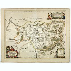
Ducatus Silesiae Grotganus cum Districtu Episcopali Nissensi Delineatore Iona Sculteto, Silesio.
Attractive engraved map of Upper Silesia prepared by Joanus Scultetus, a Silesian cartographer (1603-1664) and published by J. Janssonius. Showing the area around Nysa an...
- $400 / ≈ €374
Place & Date: Amsterdam, 1650
Silesia Inferior..
Decorative map prepared by Jonas Scultetus, a Silesian cartographer (1603-1664).
- $400 / ≈ €374
Place & Date: Amsterdam, 1650
HERTZOGTHUMB POMMERN DUCHE DE POMERANIE divise en ses Princip les Parties qui sont les Princip te de Rugue, Duche de Stettin, Pomeranie, Cassubie, et Wandalie . . .
Very fine map of the northern part of Poland. Nice details of forests, villages and rivers. Two nice uncolored cartouches.Nicolas Sanson was to bring about the rise of Fr...
- $300 / ≈ €281
Place & Date: Paris, 1654
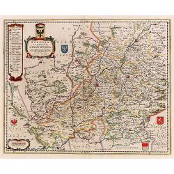
Silesiae Ducatus..
Centered on Breslaw. Including the towns of Dresden, Crakaw, Pragu, Olmitz, etc.Decorative map prepared by Jonas Scultetus, a Silesian cartographer (1603-1664).
- $600 / ≈ €561
Place & Date: Amsterdam 1660
Prussia accurate descriptia a Gasparo Henneberg Erlichensi.
Prussia and the Baltic Region, with two large decorative cartouches, coat of arms and three sailing ships. As indicated in the title cartouche, the map was prepared by th...
- $900 / ≈ €842
Place & Date: Amsterdam, 1660
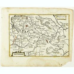
Moscovie. (34).
Scarce map of Muscovy and part of Poland and Lithuania published by Antoine de Fer in 1661 or 1662 in "Cartes de géographie revues et augmentées". The series ...
- $150 / ≈ €140
Place & Date: Paris, Antoine de Fer, 1657 but 1661 or 1662
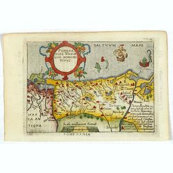
Pomeraniae Wandalice Regionis Tipus.
Miniature map of Pomerania embellished by rich cartouche, vessel and sea monsters in the Baltic. Abraham Ortelius (1527-1598) was a cartographer and publisher, who is bor...
- $250 / ≈ €234
Place & Date: Antwerp, 1667
Estats de la Couronne de Pologne.
Map of Poland prepared by N.Sanson and published by F. Halma.Published in an Dutch edition of the small Sanson atlas L'Europe Dediée a Monseigneur . . . Le Tellier Secre...
Place & Date: Amsterdam, Utrecht, 1683

Magnae Prussiae Ducatus Tabula denuo correcta et in lucem edita per Nicolaum Visscher.
Striking old color example of Visscher's map of Prussia and part of the Baltic region. Includes a gorgeous cartouche and banner key held aloft by 2 cherubs, plus 4 sailin...
- $1500 / ≈ €1404
Place & Date: Amsterdam, 1690
Il Ducato di Silesia et il Marchesato di Moravia
Scarce two-sheet map of the region along the River Oder in Poland, including parts of Chez Republic and Hungary. Excellent detail throughout. Large and decorative title a...
- $1200 / ≈ €1123
Place & Date: Rome, 1692
Le Duche de Pomeranie divise en ses principales parties. . .
Fine map of Pomerania with a decorative title and scale cartouche.The map notes Nicolas Sanson as the mapmaker and claims that the map was published by Alexis-Hubert Jail...
- $550 / ≈ €515
Place & Date: Amsterdam, 1693
Silesia Inferiore Dedicata Dal P. Cosmografo Coronelli All'Illustrissimo Eccelleniss. S. GIO: BATTISTA GRADENIGO, Senatore Amplissimo
Uncommon map of lower Silesia engraved in Coronelli's strong and distinctive style. In upper right corner a imposing dedicational cartouche surmounted by coats of arms an...
- $400 / ≈ €374
Place & Date: Venice, 1695
Ducatus Prussiae tam Polono Regiae. . .
Rare issue of Frederick de Wit's attractive map of the northern part of Poland, Prussia and the Baltic regions.Very decorative title cartouche including 3 coats of arms. ...
- $3500 / ≈ €3275
Place & Date: Amsterdam, 1698
![[No title] Germany and Poland.](/uploads/cache/37522-250x250.jpg)
[No title] Germany and Poland.
A untitled miniature map od Gemany and Poland by the German cartographer Johann Ulrich Müller. The map shows the regions of present-day Poland and Germany.For such a sma...
- $180 / ≈ €168
Place & Date: Ulm, c 1703
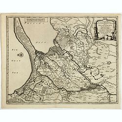
Les trois Iles, appellées en Allemand Werders, ou sont les Territoires de Dantzic, Marienbourg et Elbing dans la Prusse Royale avec les Côtes de la Mer Baltique, suivant la description de Olaus Jean Gotho, et autres Celebres Auteurs. . .
Fine and uncommon map including the town of Danzig and the region south of it. East to the top.Issued in Pierre van der Aa's very rare atlas "Nouvel Atlas …" ...
- $650 / ≈ €608
Place & Date: Leiden, 1710
Les trois Iles, appellées en Allemand Werders, ou sont les Territoires de Dantzic, Marienbourg et Elbing dans la Prusse Royale avec les Côtes de la Mer Baltique, suivant la description de Olaus Jean Gotho...
Decorative regional map including the town of Danzig and the region south of it. East to the top. This well-executed engraving was published in 1729 and 1727 by Pieter va...
- $450 / ≈ €421
Place & Date: Leiden, 1719
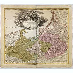
Regnum Borussiae gloriosis auspicijs Seerenissimi et Potentissimi Princip Friderici III Primi . . .
Map covering the region along the Baltic Sea from Prussia, Memel, to northern Poland, extending south to Poland, centered on Danzig, Konigsberg, Heilsperg, etc. Beautiful...
- $350 / ≈ €328
Place & Date: Nuremberg, 1720
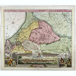
Prospect, Grundriss und Gegend der Polnischen vesten Reichs und Handels-Stadt Dantzig und ihrem Werder. . .
Striking example of Homann's map of Danzig (Gdansk) and neighboring regions and striking birds eye view, major port to the Baltic Ocean, which for centuries was an import...
- $550 / ≈ €515
Place & Date: Nuremberg, ca. 1720
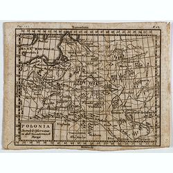
Polonia secondo le obzervazioni dell'accademiadi Parigi.
Uncommon Italian map of present day Poland and Lithuania prepared by Claude Buffier was a Jesuit theologian and geographer working in Paris, who wrote the Geographie Univ...
- $150 / ≈ €140
Place & Date: Naples, Rome, ca. 1725
Ducatus Silesiae Iauranus. Aut : Frid : Kühnovio. . .
Rare Pieter Schenk edition of Friedrich Kubn's (Kühnovio) map of Jawor in southwest Poland based on Johann Gottfried Bartsch, map first published in Świdnica (then Schw...
Place & Date: Amsterdam, 1700-1725
Selling price: $1250
Sold in 2017